Bylaw PDF

City of Edmonton | Zoning Bylaw 20001

Passed by Council on October 23, 2023, effective January 1, 2024

Land Acknowledgement

The lands on which Edmonton sits and the North Saskatchewan River that runs through it have been the sites of natural abundance, ceremony and culture, travel and rest, relationship building, making and trading for Indigenous peoples since time immemorial.

Edmonton is located within Treaty 6 Territory and within the Métis homelands and Otipemisiwak Metis Government, including District 9- Fort Edmonton and District 10-Edmonton Whitemud.

We acknowledge this land as the traditional territories of many First Nations such as the Nehiyaw (Cree), Denesuliné (Dene), Nakota Sioux (Stoney), Anishinaabe (Saulteaux) and Niitsitapi (Blackfoot).

The City of Edmonton owes its strength and vibrancy to these lands and the diverse Indigenous peoples whose ancestors’ footsteps have marked this territory as well as settlers from around the world who continue to be welcomed here and call Edmonton home.

Together, we call upon all our collective honoured traditions and spirits to work in building a great city for today and future generations.

How to use this bylaw
Part 1 - Contents and Zoning Map
  • Determine your property’s zone by looking up the address in the Zoning Map.

Part 2 - Standard Zones and Overlays

Part 3 - Special Area Zones

Part 4 - Direct Control Zones

  • Review the rules in the zone that applies to your property.
  • Review the rules in an overlay (Part 2) if it applies to your property. An overlay is a set of additional zoning rules that are applied to specific and special areas around the city. It can override or add to the rules of the underlying zone.

Part 5 - General Development Regulations

Part 6 - Specific Development Regulations 

  • Review the general regulations that may apply to your property, such as Parking, Landscaping or Site Performance Standards.
  • Review for any specific requirements related to the proposed uses on the property.
Part 7 - Administrative Regulations
  • Review for any administrative or interpretive regulations regarding the bylaw, development permits and enforcement.
  • Review Section 7.120 - No Development Permit Required to see the types of development and uses that do not require a development permit.
Part 8 - Definitions 
  • Review the definitions to ensure a clear understanding of the terms used in this bylaw. The definitions are separated by land use and other related (general) terms. 
#
  • This icon means there is 'Additional Information' available to help provide clarification or direct you to additional resources.
  • This information is not part of the Zoning Bylaw and is provided for informational purposes only.
  a
  • This icon means there has been an amendment to the Zoning Bylaw and provides information on the Charter Bylaw and when the amendment occurred.
  • This information is not part of the Zoning Bylaw and is provided for informational purposes only.

This online version of the City of Edmonton Zoning Bylaw is a reproduction of legal bylaws, and is consolidated for convenience only. Although all reasonable attempts were made in the production of these consolidations to accurately reflect the original bylaw, and any subsequent Council-approved amendments, the City of Edmonton does not assume responsibility or accept any liability arising from any use of the information presented. In case of uncertainty, the reader is advised to consult the original bylaws, available at the Office of the City Clerk.

Any interpretation or inquiries regarding the Zoning Bylaw can be directed to the Urban Planning and Economy (UPE) Department via 311.

Part 1 - Contents and Zoning Map

1.10 Title and Contents

1.1. Zoning Bylaw 20001 may be cited as the Zoning Bylaw.
1.2. Unless otherwise referenced in a Direct Control Zone or Agreement, references to “this Bylaw” are interpreted to be references to Zoning Bylaw 20001 including, but not limited to, the Direct Control Zones contained therein.


2.1. The contents of this Bylaw include:
 
2.1.1. Part 1 - Contents and Zoning Map
2.1.2. Part 2 - Standard Zones and Overlays
2.1.3. Part 3 - Special Area Zones
2.1.4. Part 4 - Direct Control Zones
2.1.5. Part 5 - General Development Regulations
2.1.6. Part 6 - Specific Development Regulations
2.1.7. Part 7 - Administrative and Interpretive Regulations
2.1.8. Part 8 - Definitions


Part 2 - Standard Zones and Overlays

2.10 RS - Small Scale Residential Zone

To allow for a range of small scale Residential development up to 3 Storeys in Height, including detached, attached, and multi-unit Residential housing. Limited opportunities for community and commercial development are permitted to provide services to local residents.

Residential Uses
3.1. Home Based Businesses must comply with Section 6.60.
3.2. Residential
 
3.2.1. The maximum number of Dwellings on an Interior Site is 8.
3.2.2. The maximum number of Lodging House Sleeping Units is 8 per Site.
3.3.3. Backyard Housing must comply with Section 6.10.
Commercial Uses
3.3. Food and Drink Services, Health Services, Indoor Sales and Services, and Offices
 
3.3.1. These Uses are only permitted where an Interior Side Lot Line Abuts a Site in a non-residential Zone that permits Commercial Uses, at the time of Development Permit application. 
3.3.2. Where one or more of these Uses are proposed in a building previously developed as Semi-detached Housing or Row Housing, the entire building must be converted for non-residential Uses
3.3.3. The maximum Floor Area is 300 m2 per individual establishment.
3.3.4. Developments must carry out their operations so that no Nuisance is created.
3.3.5. Outdoor business activity, storage, and outdoor speakers and amplification systems are not permitted.
3.3.6. Despite Subsection 3.3.5, outdoor seating areas are permitted to a maximum area of 20 m2 and must only be located in the Front Yard or Flanking Side Yard.
3.4. Residential Sales Centres may be approved for a maximum of 5 years. Subsequent Development Permits for Residential Sales Centres on the same Site must only be issued as a Discretionary Development.
Community Uses
3.5. Community Services and Child Care Services:
 
3.5.1. Community Services and Child Care Services are only permitted:
 
3.5.1.1. on Corner Sites that Abut a Collector Road or Arterial Road, except
 
3.5.1.1.1. Child Care Services are permitted on any Corner Site where proposed in a building previously developed as Single Detached Housing;
3.5.1.2. in an existing non-residential building; or
3.5.1.3. on a Site where an Interior Side Lot Line Abuts a Site in a non-residential Zone,
at the time of Development Permit application. 
3.5.2. The maximum Floor Area for Community Services is 1,000 m2 per Site.
3.5.3. The maximum Floor Area for Child Care Services is 300 m2 per Site
3.5.4. Child Care Services must comply with Section 6.40
3.6. Special Events must comply with Section 6.100.
Agricultural Uses
3.7. Urban Agriculture must not be the only Use in a principal building.
Sign Uses
3.8. Signs are limited to On-premises Advertising
3.9. Signs must comply with Section 6.90.


4.1. Development must comply with Table 4.1:
Table 4.1. Site and Building Regulations
Subsection Regulation Value Symbol
Site Dimensions
4.1.1. Minimum Site area per Dwelling 75.0 m2 -
4.1.2. Minimum Site Depth 30.0 m A
4.1.3. Minimum Site Width 7.5 m B
Lot Width for Attached Principal Dwellings
4.1.4. Minimum Lot Width where the Dwellings are developed on separate Lots not Abutting an Alley 5.0 m C
4.1.5. Minimum Lot Width where the Dwellings are developed on separate Lots Abutting an Alley 4.0 m D
 
Diagram for Subsections 4.1.2, 4.1.3, 4.1.4, and 4.1.5
Diagram for 2.10_4.1.2_-_4.1.5
Height
4.1.6. Maximum Height 10.5 m -
Site Coverage
4.1.7. Maximum Site Coverage 45% -
Building Length
4.1.8. Maximum length of any building  30.0 m E
 
Diagram for Subsection 4.1.8
Diagram for 2.10_4.1.8
4.2. Despite Subsection 4.1.7, the maximum Site Coverage is increased by 2% where: 
 
4.2.1. it is used to accommodate a single storey unenclosed front porch;
4.2.2. 1 or more buildings listed in the Inventory of Historic Resources are retained as part of a proposed development to the satisfaction of the Development Planner, in consultation with the City department responsible for heritage planning; or
4.2.3. Supportive Housing, or a minimum of 20% of all Dwellings, comply with the inclusive design requirements of Section 5.50.
4.3. Setbacks must comply with Table 4.3:
Table 4.3. Setback Regulations
Subsection Regulation Value Symbol
Front Setback
4.3.1. Minimum Front Setback 4.5 m A
 
Diagram for Subsection 4.3.1
Diagram for 2.10_4.3.1
Rear Setback
4.3.2. Minimum Rear Setback 10.0 m B
 
Diagram for Subsection 4.3.2
Diagram for 2.10_4.3.2
Side Setbacks
4.3.3. Minimum Interior Side Setback 1.2 m C
Unless the following applies:
4.3.4. Minimum Interior Side Setback when Row Housing or Multi-unit Housing faces an Interior or Flanking Side Lot Line 1.5 m D
 
Diagram for Subsections 4.3.3 and 4.3.4
Diagram for 2.10_4.3.3_and_4.3.4
4.3.5. Minimum Flanking Side Setback 1.2 m E
Unless the following applies:
4.3.6. Minimum Flanking Side Setback when a main entrance of a principal Dwelling faces a Flanking Side Lot Line 2.0 m F
 
Diagram for Subsections 4.3.5 and 4.3.6
Diagram for 2.10_4.3.5_and_4.3.6
4.4. Driveway length must comply with Table 4.4:
Table 4.4. Driveway Length Regulations
Subsection Regulation Value Symbol
Site Area
4.4.1. Minimum Driveway length between a Garage door and the back of an existing or approved sidewalk at the time of the Development Permit application 6.0 m A
Unless the following applies:
4.4.2. Minimum Driveway length between a Garage door and the Front Lot Line or Flanking Side Lot Line, where there is no existing or approved public sidewalk at the time of the Development Permit application 5.5 m -
 
Diagram for Subsection 4.4.1
Diagram for 2.10_4.4.1
4.5. The minimum distance between a rear detached Garage and a principal Dwelling, except for Backyard Housing, on the same Site is 3.0 m.


Building Design Regulations
5.1. Where a building wall: 
 
5.1.1. faces a Street; or 
5.1.2. has a total length greater than 20 m facing a Site in a residential Zone
the Facade must be articulated using 2 or more design techniques or features to minimize the perception of massing, eliminate large blank walls, and provide visual interest. Design techniques or features may include: variations in rooflines; vertical or horizontal building wall projection or recessions; visual breaks of building Facades into smaller sections; features such as windows, balconies, or porches; use of a combination of finishing materials; or other similar techniques or features. 
5.2. Identical or mirrored front Facades are not permitted on Abutting Sites. Developments on Abutting Sites must be differentiated by 2 or more design features. This does not apply to attached Dwellings within the same building.
5.3. On Corner Sites, all principal building Facades facing a Street must use consistent exterior finishing materials and architectural features and include features such as windows, doors, or porches.
Entrance Design Regulations
5.4. All principal ground-oriented Dwellings and non-Residential Uses adjacent to a Front or Flanking Side Lot Line must have a main entrance door, porch, or landing facing either the Front or Flanking Side Lot Line, except:
 
5.4.1. this regulation does not apply to Backyard Housing, Cluster Housing or Multi-unit Housing.
5.5. All Cluster Housing and Multi-unit Housing principal buildings adjacent to a Street must have at least 1 main entrance:
 
5.5.1. facing a Street; or
5.5.2. facing an internal courtyard that is visible from a Street.
5.6. Sliding patio doors must not serve as the main entrance of a Dwelling.
5.7. Main entrances for Multi-unit Housing must incorporate weather protection features in the form of canopies, awnings, overhangs, vestibules, recessed entrances or other architectural elements to provide all-season weather protection to pedestrians and to enhance the visibility of entrances.


Parking, Loading, and Access
6.1. Vehicle access must be from an Alley where a Site Abuts an Alley
6.2. Rear attached Garages are not permitted.
6.3. Where permitted, the maximum Garage door width for a front attached Garage is 60% of the total length of the front building wall.
6.4. Surface Parking Lots must not be located between a principal building and a Street.


2.20 RSF - Small Scale Flex Residential Zone

To allow for a range of small scale Residential development up to 3 Storeys in Height, including detached, attached, and multi-unit Residential housing. This Zone has site and building regulations that provide additional development flexibility in appropriate contexts, such as new neighbourhoods and large undeveloped areas. Limited opportunities for community and commercial development are permitted to provide services to local residents.

Residential Uses
3.1. Home Based Businesses must comply with Section 6.60.
3.2. Residential
 
3.2.1. The maximum number of Lodging House Sleeping Units is 8 per Site.
3.2.2. Backyard Housing must comply with Section 6.10.
Commercial Uses
3.3. Food and Drink Services, Health Services, Indoor Sales and Services, and Offices
 
3.3.1. These Uses are only permitted where an Interior Side Lot Line Abuts a Site in a non-residential Zone that permits Commercial Uses, at the time of Development Permit application.
3.3.2. Where one or more of these Uses are proposed in a building previously developed as Semi-detached Housing or Row Housing, the entire building must be converted for non-residential Uses
3.3.3. The maximum Floor Area is 300 m2 per individual establishment.
3.3.4. Developments must carry out their operations so that no Nuisance is created.
3.3.5. Outdoor business activity, storage, speakers and amplification systems are not permitted.
3.3.6. Despite Subsection 3.3.5, outdoor seating areas are permitted to a maximum area of 20.0 m2 and must only be located in the Front Yard or Flanking Side Yard.
3.4. Residential Sales Centres may be approved for a maximum of 5 years. Subsequent Development Permits for Residential Sales Centres on the same Site must only be issued as a Discretionary Development.
Community Uses
3.5. Community Services and Child Care Services:
 
3.5.1. Community Services and Child Care Services are only permitted:
 
3.5.1.1. on Corner Sites that Abut a Collector Road or Arterial Road, except 
 
3.5.1.1.1. Child Care Services are permitted on any Corner Site where proposed in a building previously developed as Single Detached Housing;
3.5.1.2. in an existing non-residential building; or
3.5.1.3. on a Site where an Interior Side Lot Line Abuts a Site in a non-residential Zone,
at the time of Development Permit application. 
3.5.2. The maximum Floor Area for Community Services is 1,000 m2 per Site.
3.5.3. The maximum Floor Area for Child Care Services is 300 m2 per Site
3.5.4. Child Care Services must comply with Section 6.40.
3.6. Special Events must comply with Section 6.100.
Agricultural Uses
3.7. Urban Agriculture must not be the only Use in a principal building.  
Sign Uses
3.8. Signs are limited to On-premises Advertising
3.9. Signs must comply with Section 6.90.


4.1. Development must comply with Table 4.1:
Table 4.1. Site and Building Regulations
Subsection Regulation Value Symbol
Site Width - Where the Site does not Abut an Alley
4.1.1. Minimum Site Width 7.5 m A
Lot Width - Where the Site does not Abut an Alley
4.1.2. Minimum Lot Width for each attached principal Dwelling where the attached Dwellings are developed on separate Lots 5.0 m B
 
Diagram for Subsections 4.1.1 and 4.1.2
Diagram for 2.20_4.1.1-4.1.2
Site Width - Where the Site Abuts an Alley
4.1.3. Minimum Site Width 7.0 m C
Unless the following applies:
4.1.4. Minimum Site Width on a Local Road or for Reverse Housing  a   5.5 m -
Lot Width - Where the Site Abuts an Alley
4.1.5. Minimum Lot Width for Row Housing internal Dwellings developed on separate Lots 3.6 m D
4.1.6. Minimum Lot Width for Semi-detached Housing or Row Housing end Dwellings developed on separate Lots 4.8 m E
 
Diagram for Subsections 4.1.3, 4.1.4 and 4.1.5
Diagram for 2.20_4.1.3-4.1.4
Height
4.1.7. Maximum Height 12.0 m -
Site Coverage
4.1.8. Maximum Site Coverage 55% -
Building Length
4.1.9. Maximum length of any building  30.0 m F
 
Diagram for Subsection 4.1.8
Diagram for 2.20_4.1.8
4.2. Setbacks must comply with Table 4.2:
Table 4.2. Setback Regulations
Subsection Regulation Value Symbol
Front Setback
4.2.1. Minimum Front Setback 4.5 m A
Unless 1 or more of the following applies:
4.2.2. Minimum Front Setback where a Treed Boulevard is provided and vehicle access is from an Alley 3.0 m B
4.2.3. Minimum Front Setback where the development is for Reverse Housing 3.0 m C
 
Diagram for Subsections 4.2.1, 4.2.2 and 4.2.3
Diagram for 2.20_4.2.1_-_4.2.3
Rear Setback
4.2.4. Minimum Rear Setback 6.0 m D
Unless the following applies:
4.2.5. Minimum Rear Setback for a building with a rear attached Garage where the Site depth is less than or equal to 30.0 m. 1.2 m E
 
Diagram for Subsections 4.2.4 and 4.2.5
Diagram for 2.20_4.2.4-4.2.5
Interior Side Setback
4.2.6. Minimum Interior Side Setback 1.2 m G
4.2.7. Minimum Interior Side Setback for Zero Lot Line Development where the Abutting Interior Side Setback is 0 m 1.5 m H
4.2.8. Minimum Interior Side Setback for Reduced Setback Development where the Abutting Interior Side Setback is greater than or equal to 0.6 m and less than 1.2 m 1.2 m I
 
Diagram for Subsections 4.2.6, 4.2.7, and 4.2.8
Diagram for 2.20_4.2.6_-_4.2.8
Unless the following applies:
4.2.9. Minimum Interior Side Setback when Row Housing or Multi-unit Housing faces an Interior or Flanking Side Lot Line 1.5 m J
 
Diagram for Subsections 4.2.9
Diagram for 2.20_4.2.9
Flanking Side Setback
4.2.10. Minimum Flanking Side Setback 2.0 m K
 
Diagram for Subsections 4.2.10
Diagram for 2.20_4.2.10
4.3. Driveway length must comply with Table 4.3:
Table 4.3. Driveway Length Regulations
Subsection Regulation Value Symbol
4.3.1. Minimum Driveway length between a Garage door and the back of an existing or approved sidewalk at the time of the Development Permit application 6.0 m A
Unless the following applies:
4.3.2. Minimum Driveway length between a Garage door and the Front Lot Line or Flanking Side Lot Line, where there is no existing or approved sidewalk at the time of the Development Permit application 5.5 m -
 
Diagram for Subsection 4.3.1
Diagram for 2.20_4.3.1
Building Design Regulations
5.1. For Multi-unit Housing, where a building wall:
 
5.1.1. faces a Street; or
5.1.2. has a total length greater than 20 m facing a Site in a residential Zone,
the Facade must be articulated using 2 or more design techniques or features to minimize the perception of massing, eliminate large blank walls, and provide visual interest. Design techniques or features may include: variations in rooflines; vertical or horizontal building wall projection or recessions; visual breaks of building Facades into smaller sections; features such as windows, balconies, or porches; use of a combination of finishing materials; or other similar techniques or features.
Entrance Design Regulations
5.2. All principal ground-oriented Dwellings and non-Residential Uses adjacent to a Front or Flanking Side Lot Line must have a main entrance door, porch, or landing facing either the Front or Flanking Side Lot Line, except:
 
5.2.1. this regulation does not apply to Backyard Housing, Cluster Housing or Multi-unit Housing.
5.3. All Cluster Housing and Multi-unit Housing principal buildings adjacent to a Street must have at least 1 main entrance:
 
5.3.1. facing a Street; or
5.3.2. facing an internal courtyard that is visible from a Street.
5.4. Sliding patio doors must not serve as the main entrance of a Dwelling.
5.5. Main entrances for Multi-unit Housing must incorporate weather protection features in the form of canopies, awnings, overhangs, vestibules, recessed entrances or other architectural elements to provide all-season weather protection to pedestrians and to enhance the visibility of the entrance.


Parking and Access
6.1. Where a Site Abuts an Alley at the Rear Lot Line, vehicle access must be from the Alley, except that:
 
6.1.1. Vehicle access may be from a Street for a maximum of 50% of principal Dwellings per Site, not including Backyard Housing; and
6.1.2. Vehicle access may be from a Street where it will result in a consistent streetscape with Lots on the same side of the Street that do not Abut an Alley.
 
Diagram for Subsection 6.1.1
Diagram for 2.20_6.1.1


6.2. Where developed with front attached garages, Row Housing and Zero Lot Line Development must not be accessed directly from a Collector Road or located directly across from a school or public park Site.
6.3. Surface Parking Lots must not be located between a principal building and a Street.
Additional Regulations for Zero Lot Line Development and Reduced Setback Development
6.4. Zero Lot Line Development is permitted where:
 
6.4.1. all roof drainage from principal and Accessory buildings is directed towards a Street, Alley, or private drainage system, and no roof leader discharge is directed to the easement area required in Subsection 6.4.2; and
6.4.2. the owners of impacted Lots register on title a minimum 1.5 m private easement along the entire distance of the shared Lot line that requires:
 
6.4.2.1. construction of a drainage swale and an unobstructed drainage path with a minimum width of 0.3 m to be free and clear of all objects;
6.4.2.2. protection of drainage of the Site, including the right for water to flow across Lots and the requirement not to inhibit the flow of water across Lots;
6.4.2.3. a 0.3 m eave encroachment easement with the requirement that the eaves must not be closer than 0.9 m to the eaves of a building on an Abutting Lot;
6.4.2.4. a 0.6 m footing encroachment easement;
6.4.2.5. permission to access the easement area for maintenance of the properties;
6.4.2.6. adequate access for utility maintenance, where applicable; and
6.4.2.7. that an Accessory building must not encroach on the easement.
Diagram for Subsection 6.4.2
Diagram for 2.20_6.4.2


6.5. Where provided, side entrances on Zero Lot Line Developments must not be developed more than 0.3 m above the finished ground surface. 
6.6. Reduced Setback Development is permitted where:
 
6.6.1. eaves are a minimum of 0.45 m from the Interior Side Lot Line;
6.6.2. all roof drainage from principal and Accessory buildings is directed towards a Street, Alley, or private drainage system, and no roof leader discharge is directed to the easement area required in Subsection 6.6.3; and
6.6.3. the owners of impacted Lots register on title a minimum 0.6 m private easement along the entire distance of the shared Lot line. The easement must: 
 
6.6.3.1. be located entirely on the Lot with the minimum 1.2 m Interior Side Setback
6.6.3.2. ensure a 0.15 m wide unobstructed drainage path along each side of the shared Lot line; and
6.6.3.3. require permission to access the easement area to allow for maintenance of the Lot with a smaller Interior Side Setback.
 
Diagram for Subsection 6.6.3
Diagram for 2.20_6.6.3


6.7. Fences are not permitted within the Interior Side Yard of a Reduced Setback Development.
 
Diagram for Subsection 6.7
Diagram for 2.200_6.8

2.30 RSM - Small-Medium Scale Transition Residential Zone

To allow for a range of small to medium scale Residential development up to 3 or 4 Storeys in Height, in the form of Row Housing and Multi-unit Housing in developing and redeveloping areas. Single Detached Housing, Semi-detached Housing, and Duplex Housing are not intended in this Zone unless they form part of a larger multi-unit Residential development. The scale of development in this Zone may act as a transition between small scale Residential development and larger scale Residential development. Limited opportunities for community and commercial development are permitted to provide services to local residents. 

Residential Uses
3.1. Home Based Businesses must comply with Section 6.60.
3.2. Residential
 
3.2.1. The maximum number of Sleeping Units in a Lodging House is 8.
3.2.2. Backyard Housing must comply with Section 6.10.
3.2.3. Single Detached Housing, Semi-detached Housing and Duplex Housing are only permitted where:
 
3.2.3.1. existing as of January 1, 2024; or
3.2.3.2. developed on the same Lot as Row Housing or Multi-unit Housing.
Commercial Uses
3.3. Food and Drink Services, Health Services, Indoor Sales and Services, and Offices
 
3.3.1. These Uses are only permitted where an Interior Side Lot Line of a Site Abuts a Site in a non-residential Zone that permits Commercial Uses at the time of Development Permit application. 
3.3.2. Where one or more of these Uses are proposed in a building previously developed as Semi-detached Housing or Row Housing, the entire building must be converted for non-residential Uses
3.3.3. The maximum Floor Area is 300 m2 per individual establishment.
3.3.4. Where a building is greater than 12 m in Height or greater than 30 m in length, Commercial Uses are limited to the Ground Floor.
3.3.5. Developments must carry out their operations so that no Nuisance is created.
3.3.6. Outdoor business activity, storage, and outdoor speakers and amplification systems are not permitted.
3.3.7. Despite Subsection 3.3.6, outdoor seating areas are permitted, limited to a maximum area of 20 m2 and must only be located in the Front Yard or Flanking Side Yard
3.4. Residential Sales Centres may be approved for a maximum of 5 years. Subsequent Development Permits for Residential Sales Centres on the same Site may only be issued as a Discretionary Development.
Community Uses
3.5. Community Services and Child Care Services
 
3.5.1. These Uses are only permitted:
 
3.5.1.1. on Corner Sites that Abut a Collector Road or Arterial Road
3.5.1.2. in an existing non-residential building; or
3.5.1.3. on a Lot that Abuts a Site
 
3.5.1.3.1. in a non-residential Zone; or
3.5.1.3.2. in a residential Zone that has a maximum Height greater than or equal to 16.0 m,
at the time of Development Permit application.
3.5.2. The maximum Floor Area for Community Services is 1,000 m2 per Site.
3.5.3. The maximum Floor Area for Child Care Services is 300 m2 per Site.
3.5.4. Child Care Services must comply with Section 6.40.
3.6. Special Events must comply with Section 6.100.
Agricultural Uses
3.7. Urban Agriculture must not be the only Use in a principal building.
Sign Uses
3.8. Signs are limited to On-premises Advertising
3.9. Signs must comply with Section 6.90.


4.1. The maximum Height must comply with Table 4.1:
4.1. Maximum Height
Subsection Modifier on Zoning Map Maximum Height
4.1.1. h12 12.0 m
4.1.2. h14 14.0 m
4.2. Development must comply with Table 4.2:
Table 4.2. Site and Building Regulations
Subsection Regulation Value Symbol
Site Width
4.2.1. Minimum Site Width 5.0 m A
Lot Width
4.2.2. Minimum Lot Width for Row Housing internal Dwellings where developed on separate Lots Abutting an Alley 3.6 m B
4.2.3. Minimum Lot Width for Semi-detached Housing or Row Housing end Dwellings where developed on separate Lots Abutting an Alley 4.8 m C
 
Diagram for Subsections 4.2.1, 4.2.2, and 4.2.3
Diagram for 2.30_4.2.1-4.2.3
Residential Density
4.2.4. Minimum Density 45 Dwellings/ha -
Site Coverage
4.2.5. Maximum total Site Coverage 60% -
Building Length
4.2.6. Maximum length of any building 45.0 m D
 
Diagram for Subsection 4.2.6
Diagram for 2.30_4.2.6
4.3. Setbacks must comply with Table 4.3:
Table 4.3. Setback Regulations
Subsection Regulation Value Symbol
Front Setback
4.3.1. Minimum Front Setback 4.5 m A
Unless the following applies:
4.3.2. Minimum Front Setback where a Treed Boulevard is provided and vehicle access is from an Alley 3.0 m B
 
Diagram for Subsections 4.3.1 and 4.3.2
Diagram for 2.30_4.3.14.3.2
Rear Setback
4.3.3. Minimum Rear Setback 5.5 m C
 
Diagram for Subsection 4.3.3
Diagram for 2.30_4.3.3
Side Setbacks
4.3.4. Minimum Interior Side Setback 1.2 m D
Unless the following applies:
4.3.5. Minimum Interior Side Setback when Row Housing or Multi-unit Housing face an Interior or Flanking Side Lot Line 1.5 m E
 
Diagram for Subsections 4.3.4 and 4.3.5
Diagram for 2.30_4.3.4_-_4.3.5
4.3.6. Minimum Flanking Side Setback 2.0 m F
 
Diagram for Subsection 4.3.6
Diagram for 2.30_4.3.6
4.4. Driveway lengths must comply with Table 4.4:
Table 4.4. Driveway Length Regulations
Subsection Regulation Value Symbol
4.4.1. Minimum Driveway length between a Garage door and the back of an existing or approved public sidewalk 6.0 m A
Unless the following applies:
4.4.2. Minimum Driveway length between the Garage door and the Front Lot Line or Flanking Side Lot Line, where there is no existing or approved public sidewalk at the time of the Development Permit application  5.5 m -
 
Diagram for Subsection 4.4.1
Diagram for 2.30_4.4.1
Building Design Regulations
5.1. Where a building wall: 
 
5.1.1. faces a Street; or 
5.1.2. has a total length greater than 20 m facing a Site in a residential Zone
the Facade must be articulated using 2 or more design techniques or features to minimize the perception of massing, eliminate large blank walls, and provide visual interest. Design techniques or features may include: variations in rooflines; vertical or horizontal building wall projection or recessions; visual breaks of building Facades into smaller sections; features such as windows, balconies, or porches; use of a combination of finishing materials; or other similar features.
5.2. On Corner Sites, the principal building Facades facing a Street must use consistent exterior finishing materials and architectural features and include features such as windows, doors, or porches.
Entrance Design Regulations
5.3. All principal ground-oriented Dwellings and non-Residential Uses adjacent to a Front or Flanking Side Lot Line must have a main entrance door, porch, or landing facing either the Front or Flanking Side Lot Line, except: 
 
5.3.1. this regulation does not apply to Backyard Housing; and
5.3.2. this regulation does not apply to Cluster Housing or Multi-unit Housing with a building length less than or equal to 30.0 m.
5.4. All Cluster Housing and Multi-unit Housing principal buildings with a building length less than or equal to 30.0 m, adjacent to a Street must have at least 1 main entrance:
 
5.4.1. facing a Street; or
5.4.2. facing an internal courtyard that is visible from a Street.
5.5. Sliding patio doors must not serve as the main entrance of a Dwelling.
5.6. Main entrances for Multi-unit Housing must incorporate weather protection features in the form of canopies, awnings, overhangs, vestibules, recessed entrances or other architectural elements to provide all-season weather protection to pedestrians and to enhance the visibility of entrances.


2.40 RM - Medium Scale Residential Zone

Residential Uses
3.1. Home Based Businesses must comply with Section 6.60.
3.2. Residential
 
3.2.1. Single Detached Housing, Semi-detached Housing and Duplex Housing are only permitted where:
 
3.2.1.1. existing as of January 1, 2024; or
3.2.1.2. developed on the same Site as Multi-unit Housing.
3.2.2. Backyard Housing must comply with Section 6.10.
Commercial Uses
3.3. Food and Drink Services, Health Services, Indoor Sales and Services, Minor Indoor Entertainment and Offices
 
3.3.1. Developments must only be located on the Ground Floor of residential buildings.
3.3.2. The maximum Floor Area is 300 m2 per individual establishment.
3.4. Residential Sales Centres may be approved for a maximum of 5 years. Subsequent Development Permits for Residential Sales Centres on the same Site may only be issued as a Discretionary Development.
Community Uses
3.5. Child Care Services must comply with Section 6.40.
3.6. Special Events must comply with Section 6.100.
Agricultural Uses
3.7. Urban Agriculture must not be the only Use in a principal building.
Sign Uses
3.8. Signs are limited to On-premises Advertising
3.9. Signs must comply with Section 6.90.


4.1. Maximum Height, maximum Floor Area Ratio and minimum Density must comply with Table 4.1:
4.1. Maximum Height, Maximum Floor Area Ratio and Minimum Density
Subsection Modifier on Zoning Map Maximum Height Maximum
Floor Area Ratio
Minimum Density
4.1.1. h16.0 16.0 m 2.3 45 Dwellings/ha
4.1.2. h23.0 23.0 m 3.0 75 Dwellings/ha
4.1.3. h28.0 28.0 m 3.8 90 Dwellings/ha
4.2. The maximum Floor Area Ratio is increased by 0.7 where a minimum of 10% of all Dwellings
 
4.2.1. comply with the inclusive design requirements of Section 5.50;
4.2.2. have a Floor Area greater than 100 m2, a minimum of 3 bedrooms; and
 
4.2.2.1. access to an outdoor Common Amenity Area designed for children that is at least 50.0 m2; and
4.2.2.2. access to dedicated and enhanced bulk storage within the Dwelling or within the building; or
4.2.3. comply with any combination of Subsections 4.2.1 and 4.2.2.
4.3. The maximum Floor Area Ratio is increased by 0.7 where:
 
4.3.1. a minimum of 30% of all Supportive Housing Sleeping Units comply with the inclusive design requirements of Section 5.50; or
4.3.2. 1 or more buildings listed on the Inventory of Historic Resources is maintained as part of a proposed development to the satisfaction of the Development Planner, in consultation with the City department responsible for heritage planning.
4.4. Development must comply with Table 4.4:
Table 4.4. Building Regulations
Subsection Regulation Value Symbol
Building Length
4.4.1. Maximum total length of any building for new buildings and additions 80.0 m -
Setbacks Abutting Streets
4.4.2. Minimum Setback where a Treed Boulevard is present 3.0 m A
4.4.3. Minimum Setback where a Treed Boulevard is not present 4.5 m B
Unless the following applies:
4.4.4. Minimum Setback where non-Residential Uses are developed on the Ground Floor and form a Main Street Development 1.0 m -
Setbacks Abutting Alleys
4.4.5. Minimum Setback 3.0 m C
 
Diagram for Subsections 4.4.2, 4.4.3, and 4.4.5
Diagram showing minimum Setbacks Abutting Streets and Alleys
Setbacks Abutting Sites
4.4.6. Minimum Setback 3.0 m D
Unless the following applies:
4.4.7. Minimum Interior Side Setback for buildings less than or equal to 12.0 m in Height 1.5 m E
 
Diagram for Subsections 4.4.6 and 4.4.7
Diagram showing minimum Setbacks Abutting Sites
4.5. Despite Subsection 4.4.6, for buildings greater than 12.0 m in Height, the minimum Setback from an Abutting Site in a residential Zone that has a maximum Height of 12.0 m or less must comply with Table 4.5:
Table 4.5. Minimum Transition Setback Regulations
Subsection Regulation Minimum Setback for buildings greater than 12.0 m in Height  Symbol Minimum Setback for portions of the building greater than 16.0 m in Height Symbol
4.5.1. Where the building wall facing the Abutting Site is less than or equal to 40.0 m in length 3.0 m A 6.0 m B
4.5.2. Where the building wall facing the Abutting Site is greater than 40.0 m in length 6.0 m C 9.0 m D
 
Diagram for Subsection 4.5
Diagram showing minimum transition Setbacks for building walls less than or equal to 40.0 m in length
Diagram showing minimum transition Setbacks for building walls greater than 40.0 m in length
4.6. Despite Subsection 4.5.2, where the required minimum Setback is 9.0 m, this is reduced to 6.0 m where a Landscape Buffer is provided in compliance with Subsection 5 of Section 5.60, except:
 
4.6.1. the Setback Abutting the south Lot line of a Site in a residential Zone must not be reduced.


#


Building Design Regulations
5.1. Where a building wall:
 
5.1.1. faces a Street; or
5.1.2. faces a Site in a residential or mixed use Zone
the Facade must be articulated using 2 or more design techniques or features to minimize the perception of massing, eliminate large blank walls, and provide visual interest. Design techniques or features may include: variations in rooflines; vertical or horizontal building wall projection or recessions; visual breaks of building Facades into smaller sections; features such as windows, balconies, or porches; use of a combination of finishing materials; or other similar techniques or features.
5.2. To promote pedestrian interaction and safety, Ground Floor non-Residential Facades must comply with the following:
 
5.2.1. Where a Facade faces a Street, a minimum of 50% of the Facade area between 1.0 m and 2.0 m above ground level must be windows.
5.2.2. A maximum of 10% of the Facade area windows facing a Street, a Park, or along Facades with a main entrance facing Parking Areas interior to the Site may be covered by non-transparent material. The remainder must be clear, non-reflective and free from obstruction.
 
Diagram for Subsection 5.2
Diagram showing design regulations for Ground Floor, non-Residential Facades
5.3. On Corner Sites, the principal building Facades facing a Street must use consistent exterior finishing materials and architectural features, and include features such as windows, doors, or porches.
Entrance Design Regulations
5.4. Principal buildings located adjacent to a Street with an existing or approved sidewalk must have an entrance facing a Street with an existing or approved sidewalk. 
5.5. Main entrances must incorporate weather protection features in the form of canopies, awnings, overhangs, vestibules, recessed entrances or other architectural elements to provide all-season weather protection to pedestrians and to enhance the visibility of entrances. 
5.6. Where: 
 
5.6.1. the building length is greater than 30.0 m;
5.6.2. the building Facade fronts onto a Street with an existing or approved sidewalk; and
5.6.3. the Setback from the Street with an existing or approved sidewalk is 4.5 m or less,
each Ground Floor Dwelling must have an individual entrance with direct outside access to a Street with an existing or approved sidewalk.
5.7. Sliding patio doors must not serve as the individual entrance required under Subsection 5.6.


#


Parking, Loading, and Access
6.1. Vehicle access must be from an Alley where a Site Abuts an Alley.
6.2.  Surface Parking Lots, and loading and waste collection areas must not be located between a principal building and a Street.
6.3. Despite the Setbacks specified in Table 4.4, Surface Parking Lots and loading and waste collection areas may project into a Setback from:
 
6.3.1. an Alley; and
6.3.2. an Abutting Site, where a minimum 1.5 m wide Landscape Buffer is provided within the Setback.


2.50 RL - Large Scale Residential Zone

To allow for high-rise Residential development that ranges from approximately 9 to 20 Storeys. Row Housing is not intended in this Zone unless it forms part of a larger multi-unit Residential development. Limited opportunities for community and commercial development are permitted to provide services to local residents.   

Residential Uses
2.1. Home Based Business #
2.2. Residential, limited to:
 
2.2.1. Lodging House
2.2.2. Multi-unit Housing
2.2.3. Row Housing
2.2.4. Secondary Suite
2.2.5. Supportive Housing
Commercial Uses
2.3. Food and Drink Service
2.4. Health Service
2.5. Indoor Sales and Service
2.6. Minor Indoor Entertainment
2.7. Office
2.8. Residential Sales Centre
Community Uses
2.9. Child Care Service
2.10. Community Service
2.11. Library
2.12. Park
2.13. Special Event
Agricultural Uses
2.14. Urban Agriculture
Sign Uses
2.15. Fascia Sign
2.16. Freestanding Sign
2.17. Portable Sign
2.18. Projecting Sign


Residential Uses
3.1. Home Based Businesses must comply with Section 6.60.
3.2. Residential
 
3.2.1. Row Housing is only permitted: 
 
3.2.1.1. where developed on the same Site as Multi-unit Housing; or 
3.2.1.2. where existing as of January 1, 2024.
Non-Residential Uses
3.3. Non-Residential Use developments, excluding Parks, Special Events and Signs, must only be located on the Ground Floor or second Storey of Residential buildings, except:
 
3.3.1. Child Care Services are permitted up to and including the fourth Storey.
Commercial Uses
3.4. The maximum Floor Area for Commercial Uses, other than Residential Sales Centres, is 300 m2 per individual establishment.
3.5. Residential Sales Centres may be approved for a maximum of 5 years. Subsequent Development Permits for Residential Sales Centres on the same Site may only be issued as a Discretionary Development
Community Uses
3.6. Child Care Services must comply with Section 6.40.
3.7. Special Events must comply with Section 6.100.
Sign Uses
3.8. Fascia Signs, Freestanding Signs, Portable Signs, and Projecting Signs are limited to On-premises Advertising.
3.9. Signs must comply with Section 6.90.
Uses with Floor Area Exceptions
3.10. The Development Planner may consider a variance to the maximum Floor Area of a non-Residential Use if adequate mitigation measures are used to reduce negative impacts to Abutting Uses or Sites, including:
 
3.10.1. measures specified in Subsection 2 of Section 5.120;
3.10.2. modification of Site plans to locate Uses or activities in a location to minimize visual, noise, lighting, odour, or other similar Nuisances; or 
3.10.3. other similar measures. 


4.1. Maximum Height and maximum Floor Area Ratio must comply with Table 4.1:
Table 4.1. Maximum Height and Floor Area Ratio
Subsection Modifier on Zoning Map Maximum Height Maximum Floor Area Ratio
4.1.1. h50.0 50.0 m 4.5
4.1.2. h65.0 65.0 m 5.5
4.2. The maximum Floor Area Ratio is increased by 1.0 where a minimum of 10% of all Dwellings:
 
4.2.1. comply with the inclusive design requirements of Section 5.50
4.2.2. have a Floor Area greater than 100 m2, a minimum of 3 bedrooms, are located below the 10th Storey of the building, and have:
 
4.2.2.1. access to an outdoor Common Amenity Area designed for children that is at least 50.0 m2; and
4.2.2.2. dedicated and enhanced bulk storage within the Dwelling or within the building; or
4.2.3. comply with any combination of Subsections 4.2.1 and 4.2.2.
4.3. The maximum Floor Area Ratio is increased by 1.0 where:
 
4.3.1. a minimum of 30% of all Supportive Housing Sleeping Units comply with the inclusive design requirements of Section 5.50; or
4.3.2. 1 or more buildings listed in the Inventory of Historic Resources is maintained as part of a proposed development to the satisfaction of the Development Planner, in consultation with the City department responsible for heritage planning.
4.4. Development must comply with Table 4.4:
Table 4.4. Setbacks Abutting Streets and Alleys
Subsection Regulation Value Symbol
Setbacks Abutting Streets
4.4.1. Minimum Setback where a Treed Boulevard is present 3.0 m A
4.4.2. Minimum Setback where a Treed Boulevard is not present 4.5 m B
Unless the following applies
4.4.3. Minimum Setback for portions of development less than or equal to 16 m in Height with: 1.0 m -
Setbacks Abutting Alleys
4.4.4. Minimum Setback 3.0 m C
 
Diagram for Subsections 4.4.1, 4.4.2, and 4.4.4
Diagram showing minimum Setbacks Abutting Streets and Alleys
4.5. Development must comply with Table 4.5:
Table 4.5. Minimum Setbacks from Abutting Sites
Subsection Regulation Value Symbol
4.5.1. Minimum Setback 3.0 m A
Unless the following applies
4.5.2. Minimum Setback for portions of development greater than 23.0 m in Height 6.0 m B
 
Diagram for Subsection 4.5.1 and 4.5.2
Diagram for 2.80_4.5.4
4.6. Development must comply with Table 4.6:
Table 4.6. Tower Regulations
Subsection Regulation Value
4.6.1. Maximum Tower Floor Plate for portions of Towers greater than 23.0 m in Height  850 m2
4.6.2. Minimum separation between Towers on the same Site or Abutting Sites, for portions of Towers greater than 23.0 m in Height 25.0 m
4.6.3. Minimum Setback for portions of Towers greater than 23.0 m in Height from an Abutting Street 6.0 m
4.7. Towers must mitigate microclimatic impacts based on a Wind Impact Assessment and Sun Shadow Impact Study, where applicable, in compliance with Section 7.140.
4.8. The Development Planner may consider a variance to the regulations in Table 4.6, taking into consideration factors such as:
 
4.8.1. the orientation and placement of the Tower and associated visual, sun, shadow, and microclimatic impacts on Amenity Areas, Pathways, and Abutting residential or mixed use developments; 
4.8.2. the context of the Site in relation to the location and Height of buildings on Abutting Sites; and
4.8.3. recommendations and mitigation measures specified in any required technical studies or applicable urban design guidelines. 


#


Building Design Regulations
5.1. Where a building wall:
 
5.1.1. faces a Street; or
5.1.2. has a total length greater than 20.0 m facing a Site in a residential or mixed use Zone,
the Facade must be articulated using 2 or more design techniques or features to minimize the perception of massing, eliminate large blank walls, provide visual interest, and enhance the appearance of buildings during winter months. Design techniques or features may include: variations in rooflines; vertical or horizontal building wall projections or recessions; visual breaks of building Facades into smaller sections; use of a combination of finishing materials; or other similar techniques or features. 
5.2. Subsection 5.1 does not apply to Facades of a Tower above:
 
5.2.1. a Podium; or 
5.2.2. 23.0 m in Height.
5.3. To promote pedestrian interaction and safety, Ground Floor non-Residential Facades must comply with the following:
 
5.3.1. Where a Facade faces a Street, a minimum of 50% of the Facade area between 1.0 m and 2.0 m above ground level must be windows.
5.3.2. A maximum of 10% of the Facade area windows facing a Street, a Park, or along Facades with a main entrance facing Parking Areas interior to the Site may be covered by non-transparent material. The remainder must be clear, non-reflective and free from obstruction.
Diagram for Subsection 5.3
Diagram showing design regulations for Ground Floor, non-Residential Facades
5.4. On Corner Sites, the Facade design and materials must wrap around the side of the building to provide a consistent profile facing both Streets.
Entrance Design Regulations
5.5. For new buildings and additions, where a Use is located on the Ground Floor adjacent to a Street, the main entrance for non-Residential Uses, and the main shared entrance for Multi-unit Housing or Supportive Housing must:
 
5.5.1. be directed towards the Street; and 
5.5.2. be level with, or have sloped doorway thresholds to, Abutting Pathways and public sidewalks.
5.6. Dwelling units with at-grade entrances must provide a semi-private space to act as a transition area from Streets. This can be established through the use of features such as fencing, Landscaping, porches, or other similar measures.
5.7. Main entrances must incorporate weather protection features in the form of canopies, awnings, overhangs, common vestibules, recessed entrances or other architectural elements to provide all-season weather protection to pedestrians and to enhance the visibility of entrances. 


#


Parking, Loading, Storage and Access
6.1. Vehicle access must be from an Abutting Alley. Where there is no Abutting Alley, vehicle access must:
 
6.1.1. be from the Flanking Street for Corner Sites
6.1.2. be designed to minimize disruption to vehicle and pedestrian circulation; and
6.1.3. be designed to minimize impacts to existing trees and the streetscape,
to the satisfaction of the Development Planner in consultation with the City department responsible for transportation services.
6.2. Despite the Setbacks specified in Tables 4.4 and 4.5:
 
6.2.1. Surface Parking Lots, and loading, storage, and waste collection areas must not be located between a principal building and a Street and must provide a minimum 3.0 m wide Landscape Buffer where adjacent to a Street.
6.2.2. Surface Parking Lots and loading, storage, and waste collection areas may project into, or be located within, a Setback Abutting another Site where a minimum 1.5 m wide Landscape Buffer is provided within the Setback.
6.2.3. Surface Parking Lots, and loading, storage, and waste collection areas may project into, or be located within, a Setback Abutting an Alley.
6.3. Above-ground Parkade Facades facing a Street or a Park must be screened from view at ground level and wrapped with Residential, Commercial or Community Uses with a minimum depth of 8.0 m
Other Regulations
6.4. Despite the Setbacks specified in Table 4.4, outdoor display areas and Public Space associated with a Main Street Development may be located in a Setback Abutting a Street.


2.60 RR - Rural Residential Zone

To allow for rural residential development while prohibiting further subdivision of rural residential lands.

Residential Uses
3.1. A Residential Use must only be in the form of a maximum of 1 Single Detached House, 1 Dwelling of Backyard Housing, and 1 Secondary Suite
3.2. Backyard Housing must comply with Section 6.10.
 
3.2.1. The maximum Floor Area for Backyard Housing is 130.0 m2.
3.3. Home Based Businesses must comply with Section 6.60.
Commercial Uses
3.4. Veterinary services must be located and developed on a Site in such a manner that the keeping of animals does not create a Nuisance.
Community Uses
3.5. Child Care Services must comply with Section 6.40
3.6. Special Events must comply with Section 6.100.
Agricultural Uses
3.7. Agricultural Uses must be located and developed on a Site in such a manner that the keeping of animals or livestock does not create a Nuisance
Sign Uses
3.8. Fascia Signs, Freestanding Signs, and Portable Signs are limited to On-premises Advertising
3.9. Signs must comply with Section 6.90.


2.70 MUN - Neighbourhood Mixed Use Zone

To allow for neighbourhood scale pedestrian oriented mixed use development anticipated in Local Nodes, as directed by statutory plans, that is integrated with the neighbourhood and intended to serve as a community focal point for commercial businesses, services, social gathering, and Residential Uses.

Residential Uses
2.1. Home Based Business #
2.2. Residential, limited to:
 
2.2.1. Lodging House
2.2.2. Multi-unit Housing
2.2.3. Row Housing
2.2.4. Secondary Suite
2.2.5. Supportive Housing
Commercial Uses
2.3. Bar
2.4. Body Rub Centre
2.5. Cannabis Retail Store
2.6. Custom Manufacturing
2.7. Food and Drink Service
2.8. Health Service
2.9. Hotel
2.10. Indoor Sales and Service
2.11. Liquor Store
2.12. Minor Indoor Entertainment
2.13. Office
2.14. Residential Sales Centre
2.15. Vehicle Support Service, limited to those existing prior to January 1, 2024
Community Uses
2.16. Child Care Service
2.17. Community Service
2.18. Library
2.19. Park
2.20. School
2.21. Special Event
Basic Service Uses
2.22. Emergency Service
2.23. Recycling Drop-off Centre
2.24. Transit Facility
Agricultural Uses
2.25. Urban Agriculture
Sign Uses
2.26. Fascia Sign
2.27. Freestanding Sign
2.28. Major Digital Sign
2.29. Minor Digital Sign
2.30. Portable Sign
2.31. Projecting Sign


Residential Uses
 
3.1. Home Based Businesses must comply with Section 6.60.  
3.2. Residential  
 
3.2.1. The Residential Use must be on a Site with at least 1 non-Residential Use other than a Sign Use
3.2.2. Ground Floor Residential Uses located adjacent to a Street may only be approved where:
 
3.2.2.1. located on a Corner Site and facing a Local Road; and
3.2.2.2. the Residential Ground Floor building Frontage is not more than 70% of the total building Frontage facing the Local Road.

a


Non-Residential Uses
 
3.3. All Ground Floor building Frontages adjacent to a Street must consist of non-Residential Uses oriented towards the adjacent Street, except as identified in Subsection 3.2.2.  
3.4. On Corner Sites that Abut an Arterial Road or Collector Road, and a Local Road, Ground Floor non-Residential Uses must be oriented towards and include a main entrance that faces the Abutting Arterial Road or Collector Road.  
3.5. The maximum Floor Area for non-Residential Uses is:   
 
3.5.1. 500 m2 per individual establishment, where the only Streets Abutting the Site are Local Roads;
3.5.2. 1,000 m2 per individual establishment, where located on a Site Abutting one or more Collector or Arterial Roads; or
3.5.3. 2,500 m2 per individual establishment, where located on a Site greater than 1 ha that Abuts one or more Arterial Roads.
 
Commercial Uses
 
3.6. Bars and Food and Drink Services  
 
3.6.1. Despite Subsection 3.5, the maximum Floor Area is 500 m2 per individual establishment.
 
3.7. Body Rub Centres must comply with Section 6.20.  
3.8. Cannabis Retail Stores must comply with Section 6.30.  
3.9. Custom Manufacturing  
 
3.9.1. Despite Subsection 3.5, the maximum Floor Area is 300 m2 per individual establishment, except:
 
3.9.1.1. Where Custom Manufacturing is combined with a Bar or Food and Drink Service, the maximum Floor Area is 500 m2 per individual establishment.
3.9.2. Manufacturing activities and storage must be located within an enclosed building. 
 
3.10. Hotels  
 
3.10.1. Ground Floor guest rooms must not be located adjacent to a Street.
 
3.11. Indoor Sales and Services  
 
3.11.1. Despite Subsection 3.5, the maximum Floor Area for Grocery Stores is 2,500 m2 per individual establishment.
 
3.12. Liquor Stores must comply with Section 6.70.  
3.13. Residential Sales Centres may be approved for a maximum of 5 years. Subsequent Development Permits for Residential Sales Centres on the same Site may only be issued as a Discretionary Development  
3.14. Vehicle Support Services and Uses with Drive-through Services  
 
3.14.1. Vehicle Support Services and Uses with Drive-through Services must comply with Section 6.110.
3.14.2. Uses with Drive-through Services are only permitted where existing prior to January 1, 2024.
 
Community Uses
 
3.15. Child Care Services must comply with Section 6.40.  
3.16. Special Events must comply with Section 6.100.  
Basic Service Uses
 
3.17. Basic Service Uses must be on a Site with at least 1 additional Use other than a Sign Use. a
3.18. Recycling Drop-Off Centres  
 
3.18.1. The maximum total area for a Recycling Drop-off Centre is 300 m2 per Site.
3.18.2. Recycling bins and associated drive aisles and queuing lanes must not be located between a building and a Street.
3.18.3. Perimeter screening using Fences, Landscape Buffers, or other similar features, must be provided to screen the view of drop-off areas and bins from Abutting Streets and Sites in non-industrial Zones
 
3.19. Transit Facilities  
 
3.19.1. Despite the Setbacks specified in Table 4.4, Transit Facilities may project into a Setback Abutting a Street to integrate with transit infrastructure in the road right-of-way.
 
Agricultural Uses
 
3.20. Urban Agriculture  
 
3.20.1. Despite Subsections 3.5.2 and 3.5.3, the maximum Floor Area is 600 m2 per individual establishment where located on a Site Abutting one or more Collector or Arterial Roads.
3.20.2. With the exception of outdoor display areas of products for sale, Urban Agriculture Uses must be located within or on a building.
3.20.3. The Development Planner may consider a variance to Subsection 3.20.2 based on the recommendations provided in an environmental or risk assessment report in compliance with Section 7.140
 
Sign Uses
 
3.21. Fascia Signs, Freestanding Signs, Portable Signs, and Projecting Signs are limited to On-premises Advertising, except that:   
 
3.21.1 Off-premises Advertising is permitted where existing as of January 1, 2024.
 
3.22. Major Digital Signs and Minor Digital Signs are only permitted where existing as of January 1, 2024.   
3.23. Signs must comply with Section 6.90.  
Uses with Total Area and Floor Area Exceptions
 
3.24. The Development Planner may consider a variance to the maximum total area or Floor Area of a non-Residential Use if adequate mitigation measures are used to reduce negative impacts to Abutting Uses or Sites, including:  
 
3.24.1. measures specified in Subsection 2 of Section 5.120;
3.24.2. modification of Site plans to locate Uses or activities in a location to minimize visual, noise, lighting, odour or other similar Nuisances; or 
3.24.3. other similar measures. 


4.1. Development must comply with Table 4.1:
Table 4.1. Site and Building Regulations
Subsection Regulation Value
Site Area
4.1.1. Maximum Site area 2.0 ha
Height
4.1.2. Maximum Height 16.0 m
4.1.3. Minimum Ground Floor Height for non-Residential Uses in new buildings 4.0 m
Floor Area Ratio
4.1.4. Maximum Floor Area Ratio 3.5
4.2. Floor Area associated with Residential Uses is excluded from the calculation of the maximum Floor Area Ratio where a minimum of 10% of all Dwellings:
 
4.2.1. comply with the inclusive design requirements of Section 5.50;
4.2.2. have a Floor Area greater than 100 m2 and a minimum of 3 bedrooms; and
 
4.2.2.1. access to an outdoor Common Amenity Area designed for children of at least 50.0 m2; and
4.2.2.2. dedicated and enhanced bulk storage within the Dwelling or within the building; or
4.2.3. comply with any combination of Subsections 4.2.1 and 4.2.2.
4.3. The maximum Floor Area Ratio is increased by 0.7 where:
 
4.3.1. a minimum of 30% of all Supportive Housing Sleeping Units comply with the inclusive design requirements of Section 5.50; or
4.3.2. 1 or more buildings listed in the Inventory of Historic Resources is maintained as part of a proposed development to the satisfaction of the Development Planner in consultation with the City department responsible for heritage planning.
4.4. Development must comply with Table 4.4:
Table 4.4. Setback Regulations
Subsection Regulation Value Symbol
For portions of development with non-Residential Uses on the Ground Floor Abutting a Street
4.4.1. Minimum Setback 1.0 m -
4.4.2. Maximum Setback 3.0 m A
4.4.3. Maximum Setback No maximum -
Unless the following applies:
4.4.4. Minimum Setback for Ground Floor non-Residential Uses where Abutting a Street with a sidewalk width 4.7 m or greater, measured from the Lot line to the curb 0 m -
For portions of development with Residential Uses on the Ground Floor Abutting a Street
4.4.5. Minimum Setback from Abutting Streets with a Treed Boulevard 3.0 m B
4.4.6. Minimum Setback from Abutting Streets without a Treed Boulevard 4.5 m C
Setbacks Abutting Alleys
4.4.7. Minimum Setback 0 m -
Unless the following applies:
4.4.8. Minimum Setback for new buildings and additions where an Abutting Alley is less than 6.0 m wide 1.0 m D
Setbacks Abutting Sites
4.4.9. Minimum Setback 3.0 m E
Unless the following applies:
4.4.10.

Minimum Setback where Abutting a Site:

0 m -
 
Diagram for Subsection 4.4
Diagram for 2.70_4.3


#


Building Design Regulations
5.1. Where a building wall:
 
5.1.1. faces a Street or Park;
5.1.2. has a main entrance facing a Public Amenity Area or Parking Area interior to the Site; or
5.1.3. has a total length greater than 20.0 m facing a Site in a residential or mixed use Zone,
the Facade must be articulated using 2 or more design techniques or features to minimize the perception of massing, eliminate large blank walls, provide visual interest, and enhance the appearance of buildings during winter months. Design techniques or features may include: variations in rooflines; vertical or horizontal building wall projections or recessions; visual breaks of building Facades into smaller sections; use of a combination of finishing materials; or other similar techniques or features.
5.2. Subsection 5.1 does not apply to building walls facing and built to a shared Lot line to establish a continuous Street Wall with the Abutting Site.
5.3. Ground Floor non-Residential Facades facing Streets, and any Facade with a main entrance that faces a Park, must be designed to break up the appearance into sections of 11.0 m or less by incorporating 2 or more design techniques or features such as those described in Subsection 5.1.
5.4. Each Storey must have windows on all building Facades facing a Street.
5.5. To promote pedestrian interaction and safety, Ground Floor non-Residential Facades must comply with the following:
 
5.5.1. Where a Facade faces a Street, a minimum of 65% of the Facade area between 1.0 m and 2.0 m above ground level must be windows.
5.5.2. Despite Subsection 5.5.1, for exterior alterations to existing storefronts that involve adding or removing windows, a minimum of 50% of the Facade area between 1.0 m and 2.0 m above ground level facing a Street must be windows.
5.5.3. A maximum of 10% of all Ground Floor windows facing a Street, a Park, or along Facades with a main entrance facing a Public Amenity Area or Parking Area interior to the Site may be covered by non-transparent material. The remainder must be clear, non-reflective and free from obstruction.
Diagram for Subsection 5.5
Diagram for 2.80_5.9
5.6. The Facade design and materials must wrap around the side of the building to provide a: 
 
5.6.1. consistent profile facing both Streets for Corner Sites; and 
5.6.2. consistent profile for building corners facing Streets and Alleys for Interior Sites, except that Facades facing an Alley do not require windows.
Entrance Design Regulations
5.7. Ground Floor non-Residential Uses adjacent to a Street must have separate individual entrances, but may share a common vestibule.
 
Diagram for Subsection 5.7
Diagram for 2.80_5.1
5.8. For new buildings and additions, where a Use is located on the Ground Floor adjacent to a Street:
 
5.8.1. the main entrance must be directed towards the Street; and 
5.8.2. the main entrance for non-Residential Uses, and shared entrances for Multi-unit Housing or Supportive Housing must be level with, or have sloped doorway thresholds to, Abutting Pathways and public sidewalks.
5.9. Dwelling units with at-grade entrances must provide a semi-private space to act as a transition area from Streets. This can be established through the use of features such as fencing, Landscaping, porches, or other similar measures.
5.10. Main entrances must incorporate weather protection features in the form of canopies, awnings, overhangs, vestibules, recessed entrances, or other Architectural Elements to provide all-season weather protection to pedestrians and to enhance the visibility of entrances.


#


Parking, Loading, Storage and Access
6.1. Vehicle access must be from an Abutting Alley. Where there is no Abutting Alley, vehicle access must:
 
6.1.1. be from a Flanking Street for Corner Sites;
6.1.2. be designed to minimize disruption to vehicle and pedestrian circulation; and
6.1.3. be designed to minimize impacts to existing trees and the streetscape,
to the satisfaction of the Development Planner in consultation with the City department responsible for transportation services.
6.2. Despite the Setbacks specified in Table 4.4:
 
6.2.1. Surface Parking Lots and loading, storage, and waste collection areas must not be located between a principal building and a Street and must provide a minimum 2.0 m wide Landscape Buffer where adjacent to a Street.
6.2.2. Surface Parking Lots and loading, storage, and waste collection areas may project into, or be located within, a Setback Abutting another Site where a minimum 1.5 m wide Landscape Buffer is provided within the Setback
6.3. Above-ground Parkade Facades facing a Street or a Park must be wrapped with Commercial or Community Uses, with a minimum depth of 8.0 m, on the Ground Floor
6.4. Above-ground Parkades must be designed to be adaptable for future non-parking Uses by having:
 
6.4.1. a minimum floor to ceiling clearance of 4.0 m at ground level, and 3.1 m above the Ground Floor;
6.4.2. floors that can readily become level; and
6.4.3. drive ramps located and designed to allow for future removal without interfering with developable space.
Other Regulations
6.5. Despite the Setbacks specified in Table 4.4, outdoor display areas and Public Space may be located in a Setback Abutting a Street.


2.80 MU - Mixed Use Zone

To allow for varying scales of mixed use development that enables the growth and development anticipated in the Nodes and Corridors as directed by statutory plans. This Zone allows for a range of Uses and supports housing, recreation, commerce, and employment opportunities. Site and building design in this Zone promotes development that enhances the public realm and publicly accessible amenities to create vibrant, walkable destinations at a scale inviting to pedestrians.

Residential Uses
2.1. Home Based Business #
2.2. Residential, limited to:
 
2.2.1. Lodging House
2.2.2. Multi-unit Housing
2.2.3. Row Housing
2.2.4. Secondary Suites
2.2.5. Supportive Housing
Commercial Uses
2.3. Bar
2.4. Body Rub Centre
2.5. Cannabis Retail Store
2.6. Custom Manufacturing
2.7. Food and Drink Service
2.8. Health Service
2.9. Hotel
2.10. Indoor Sales and Service
2.11. Liquor Store
2.12. Major Indoor Entertainment
2.13. Minor Indoor Entertainment
2.14. Office
2.15. Residential Sales Centre
2.16. Vehicle Support Service, limited to those existing prior to January 1, 2024
Industrial Uses
2.17. Indoor Self Storage
Community Uses
2.18. Child Care Service
2.19. Community Service
2.20. Library
2.21. Park
2.22. School
2.23. Special Event
Basic Service Uses
2.24. Emergency Service
2.25. Health Care Facility
2.26. Recycling Drop-off Centre
2.27. Transit Facility
Agricultural Uses
2.28. Urban Agriculture
Sign Uses
2.29. Fascia Sign
2.30. Freestanding Sign
2.31. Major Digital Sign
2.32. Minor Digital Sign
2.33. Portable Sign
2.34. Projecting Sign


Non-Residential Uses
 
3.1. On Sites with the Commercial Frontage Modifier, all Ground Floor building Frontages adjacent to a Street must consist of non-Residential Uses oriented towards the adjacent Street, except as identified in Subsection 3.4.2.  
3.2. On Corner Sites that Abut an Arterial Road or Collector Road, and a Local Road, Ground Floor non-Residential Uses must be oriented towards, and include a main entrance that faces, the Abutting Arterial Road or Collector Road.  
Residential Uses
 
3.3. Home Based Businesses must comply with Section 6.60.  
3.4. Residential  
 
3.4.1. Row Housing is only permitted where developed on the same Site as Multi-unit Housing or non-Residential Uses.
3.4.2. Ground Floor Residential Uses located adjacent to a Street may only be approved on a Site with the Commercial Frontage Modifier where:
 
3.4.2.1. located on a Corner Site and facing a Local Road; and
3.4.2.2. the residential Ground Floor building Frontage is not more than 70% of the total building Frontage facing the Local Road.
 
Commercial Uses
 
3.5. Body Rub Centres must comply with Section 6.20.  
3.6. Cannabis Retail Stores must comply with Section 6.30.  
3.7. Custom Manufacturing  
 
3.7.1. The maximum Floor Area is 600 m2 per individual establishment.
3.7.2. Manufacturing activities and storage must be located within an enclosed building.
 
3.8. Hotels  
 
3.8.1. Ground Floor guest rooms must not be located adjacent to a Street.
 
3.9. Liquor Stores must comply with Section 6.70.  
3.10. Major Indoor Entertainment  
 
3.10.1. The maximum Floor Area is 500 m2 per individual establishment, except where located on a Site greater than 1 ha.
 
3.11. Residential Sales Centres may be approved for a maximum of 5 years. Subsequent Development Permits for Residential Sales Centres on the same Site may only be issued as a Discretionary Development  
3.12. Vehicle Support Services and Uses with Drive-through Services   
 
3.12.1. Vehicle Support Services and Uses with Drive-through Services must comply with Section 6.110.
3.12.2. Uses with Drive-through Services are only permitted where existing prior to January 1, 2024.
 
Industrial Uses
 
3.13. Indoor Self Storage  
 
3.13.1. Must not be developed as a standalone building. 
3.13.2. Must incorporate windows at regular intervals on all Storeys on Facades facing Abutting Streets. Windows must be clear, transparent and non-reflective.
3.13.3. The maximum Ground Floor building Frontage for Indoor Self Storage is 11.0 m. The remaining Ground Floor building Frontage must be used for Community Uses or Commercial Uses other than Vehicle Support Services.
 
Community Uses
 
3.14. Child Care Services must comply with Section 6.40.  
3.15. Special Events must comply with Section 6.100.  
Basic Service Uses
 
3.16. Basic Service Uses must be on a Site with at least 1 additional Use other than a Sign Use. a
3.17. Health Care Facilities  
 
3.17.1. The maximum Floor Area is 1,000 m2 per individual establishment.
 
3.18. Recycling Drop-off Centres  
 
3.18.1. The maximum total area for a Recycling Drop-off Centre on a Site is 300 m2.
3.18.2. Recycling bins and associated drive aisles and queuing lanes must not be located between a building and a Street.
3.18.3. Perimeter screening using Fences, Landscape Buffers, or other similar features, must be provided to screen the view of drop-off areas and bins from Abutting Streets and Sites in non-industrial Zones
 
3.19. Transit Facilities  
 
3.19.1. Despite the Setbacks specified in Table 4.4, Transit Facilities may project into a Setback Abutting a Street to integrate with transit infrastructure in the road right-of-way.
 
Agricultural Uses
 
3.20. Urban Agriculture  
 
3.20.1. The maximum Floor Area is 600 m2 per individual establishment.
3.20.2. With the exception of outdoor display areas of products for sale, Urban Agriculture Uses must be located within or on a building.
3.20.3. The Development Planner may consider a variance to Subsection 3.20.2 based on the recommendations provided in an environmental site assessment in compliance with Section 7.140.
 
Sign Uses
 
3.21. Signs must comply with Section 6.90.  
Uses with Total Area and Floor Area Exceptions
 
3.22. The Development Planner may consider a variance to the maximum total area or Floor Area of a non-Residential Use if adequate mitigation measures are used to reduce negative impacts to Abutting Uses or Sites, including:  
 
3.22.1. measures specified in Subsection 2 of Section 5.120;
3.22.2. modification of Site plans to locate Uses or activities in a location to minimize visual, noise, lighting, odour or other similar Nuisances; or 
3.22.3. other similar measures. 


4.1. Development must comply with Table 4.1:
Table 4.1. Building Regulations
Subsection Regulation Value
Height
4.1.1. Maximum Height The number (in metres) following the Modifier ‘h’ as indicated on the Zoning Map
4.1.2. Minimum Ground Floor Height for non-Residential Uses in new buildings 4.0 m
Floor Area Ratio
4.1.3. Maximum Floor Area Ratio The number following the Modifier ‘f’ as indicated on the Zoning Map
4.2. Floor Area associated with Residential Uses is excluded from the calculation of the maximum Floor Area Ratio where a minimum of 10% of all Dwellings:
 
4.2.1. comply with the inclusive design requirements of Section 5.50
4.2.2. have a Floor Area greater than 100 m2, a minimum of 3 bedrooms, are located below the 10th Storey of the building, and have: 
 
4.2.2.1. access to an outdoor Common Amenity Area designed for children of at least 50.0 m2; and
4.2.2.2. dedicated and enhanced bulk storage within the Dwelling or within the building; or
4.2.3. comply with any combination of Subsections 4.2.1 and 4.2.2.
4.3. The maximum Floor Area Ratio is increased by 1.0 where:
 
4.3.1. a minimum of 30% of all Supportive Housing Sleeping Units comply with the inclusive design requirements of Section 5.50; or
4.3.2. 1 or more buildings listed in the Inventory of Historic Resources is maintained as part of a proposed development to the satisfaction of the Development Planner, in consultation with the City department responsible for heritage planning.
4.4. Development must comply with Table 4.4:
Table 4.4. Setbacks Abutting Streets
Subsection Regulation Value Symbol
4.4.1. Minimum Setback 1.0 m -
4.4.2. Maximum Setback for Ground Floor non-Residential Uses 3.0 m A
4.4.3. Maximum Setback No maximum -
Unless 1 or more of the following applies:
4.4.4. Minimum Setback for Ground Floor non-Residential Uses where Abutting a Street with a sidewalk width 4.7 m or greater, measured from the Lot line to the curb 0 m -
4.4.5. Minimum Setback for portions of development with Residential Uses on the Ground Floor Abutting a Street, where a Treed Boulevard is present 3.0 m B
4.4.6. Minimum Setback for portions of development with Residential Uses on the Ground Floor Abutting a Street, where a Treed Boulevard is not present 4.5 m C
4.4.7 Minimum Setback for portions of development greater than 16.0 m in Height, or greater than the Height of the tallest Street Wall on an Abutting Site in a non-residential Zone where applicable, whichever is greater 4.5 m D
 
Diagram for Subsections 4.4.2, 4.4.5, 4.4.6 and 4.4.7
Diagram for 2.80_4.3.1_4.3.2_4.3.5_4.3.6_4.3.7
4.5. Development must comply with Table 4.5:
Table 4.5. Setbacks Abutting Alleys
Subsection Regulation Value
4.5.1. Minimum Setback 0 m
Unless 1 or more of the following applies
4.5.2. Minimum Setback for new buildings and additions where the Abutting Alley is less than 6.0 m wide 1.0 m
4.5.3. Minimum Setback for portions of development greater than 16.0 m in Height 3.0 m
4.6. Development must comply with Table 4.6:
Table 4.6. Minimum Setbacks from Abutting Sites
Subsection Regulation Value Symbol
4.6.1. Minimum Setback 3.0 m A
Unless 1 or more of the following applies:
4.6.2. Minimum Setback for portions of development less than or equal to 23.0 m in Height, where Abutting a Site: 0 m  
4.6.3. Minimum Setback for portions of development greater than 16.0 m in Height, where Abutting a Site in a residential Zone that has a maximum Height of 12.0 m or less 6.0 m B
 
Diagram for Subsections 4.6.1 and 4.6.3
Diagram for 2.80_4.5.3
4.6.4. Minimum Setback for portions of development greater than 23.0 m in Height 6.0 m C
 
Diagram for Subsections 4.6.1 and 4.6.4
Diagram for 2.80_4.5.4
4.7. Development must comply with Table 4.7:
Table 4.7. Tower Regulations
Subsection Regulation Value Symbol
4.7.1. Maximum Tower Floor Plate for portions of Towers greater than 23.0 m in Height  850 m2  
4.7.2. Minimum separation between Towers on the same Site or Abutting Sites, for portions of Towers greater than 23.0 m in Height 25.0 m  
4.7.3. Minimum Tower Setback from Abutting Streets for portions of Towers greater than 23.0 m in Height Setback provided at the Ground Floor plus an additional 4.5 m A
4.7.4. Despite Subsection 4.7.3, up to 1/3 of a Tower Facade facing an Abutting Street may extend to ground level -  
 
Diagram for Subsection 4.7.3 and 4.7.4
Diagram for 2.80_4.7.4
4.7.5. A Public Amenity Area must be provided between a Tower and a Street where a Podium is not provided -  
4.8. Towers must mitigate microclimatic impacts based on a Wind Impact Assessment and Sun Shadow Impact Study, where applicable, in compliance with Section 7.140.
4.9. The Development Planner may consider a variance to the regulations in Table 4.7, taking into consideration factors such as:
 
4.9.1. the orientation and placement of the Tower and associated visual, sun, shadow, and microclimatic impacts on Amenity Areas, Pathways, and Abutting residential or mixed use developments; 
4.9.2. the context of the Site in relation to the location and Height of buildings on Abutting Sites; and
4.9.3. recommendations and mitigation measures specified in any required technical studies or applicable urban design guidelines. 


#


Building Design Regulations
5.1. Where a building wall:
 
5.1.1. faces a Street or Park;
5.1.2. has a main entrance facing a Public Amenity Area or Parking Area interior to the Site; or
5.1.3. has a total length greater than 20.0 m facing a Site in a residential or mixed use Zone,
the Facade must be articulated using 2 or more design techniques or features to minimize the perception of massing, eliminate large blank walls, provide visual interest, and enhance the appearance of buildings during winter months. Design techniques or features may include: variations in rooflines; vertical or horizontal building wall projections or recessions; visual breaks of building Facades into smaller sections; use of a combination of finishing materials; or other similar techniques or features.
5.2. Subsection 5.1 does not apply to:
 
5.2.1. building walls facing and built to a shared Lot line to establish a continuous Street Wall with the Abutting Site; or
5.2.2. Facades of a Tower above a Podium or the Street Wall.
5.3. Ground Floor non-Residential Facades facing Streets, and any Facade with a main entrance that faces a Park, must be designed to break up the appearance into sections of 11.0 m or less by incorporating 2 or more design features such as those described in Subsection 5.1.
5.4. Each Storey must have windows on all building Facades facing a Street.
5.5. To promote pedestrian interaction and safety, Ground Floor non-Residential Facades must comply with the following:
 
5.5.1. Where a Facade faces a Street, a minimum of 65% of the Facade area between 1.0 m and 2.0 m above ground level must be windows.
5.5.2. Despite Subsection 5.5.1, for exterior alterations to existing storefronts that involve adding or removing windows, a minimum of 50% of the Facade area between 1.0 m and 2.0 m above ground level facing a Street must be windows.
5.5.3. A maximum of 10% of all Ground Floor windows facing a Street, a Park, or along Facades with a main entrance facing a Public Amenity Area or Parking Area interior to the Site may be covered by non-transparent material. The remainder must be clear, non-reflective and free from obstruction.
Diagram for Subsection 5.5
Diagram for 2.80_5.9
5.6. The Facade design and materials must wrap around the side of the building to provide a: 
 
5.6.1. consistent profile facing both Streets for Corner Sites; and 
5.6.2. consistent profile for building corners facing Streets and Alleys for Interior Sites, except that Facades facing an Alley do not require windows.
Entrance Design Regulations
5.7. Ground Floor non-Residential Uses adjacent to a Street must have separate individual entrances, but may share a common vestibule.
 
Diagram for Subsection 5.7
Diagram for 2.80_5.1
5.8. For new buildings and additions, where a Use is located on the Ground Floor adjacent to a Street, the main entrance for non-Residential Uses, and the main shared entrance for Multi-unit Housing or Supportive Housing must:
 
5.8.1. be directed towards the Street; and 
5.8.2. be level with, or have sloped doorway thresholds to, Abutting Pathways and public sidewalks.
5.9. Dwelling units with at-grade entrances must provide a semi-private space to act as a transition area from Streets. This can be established through the use of features such as fencing, Landscaping, porches, or other similar measures.
5.10. Main entrances must incorporate weather protection features in the form of canopies, awnings, overhangs, vestibules, recessed entrances, or other Architectural Elements to provide all-season weather protection to pedestrians and to enhance the visibility of entrances.


#


Parking, Loading, Storage and Access
6.1. Vehicle access must be from an Abutting Alley. Where there is no Abutting Alley, vehicle access must:
 
6.1.1. be from a Flanking Street for Corner Sites;
6.1.2. be designed to minimize disruption to vehicle and pedestrian circulation; and
6.1.3. be designed to minimize impacts to existing trees and the streetscape,
to the satisfaction of the Development Planner in consultation with the City department responsible for transportation services.
6.2. Despite the Setbacks specified in Table 4.4 and 4.6:
 
6.2.1. Surface Parking Lots and loading, storage, and waste collection areas must not be located between a principal building and a Street and must provide a minimum 2.0 m wide Landscape Buffer where adjacent to a Street.
6.2.2. Surface Parking Lots and loading, storage, and waste collection areas may project into, or be located within, a Setback Abutting another Site where a minimum 1.5 m wide Landscape Buffer is provided within the Setback
6.3. Above-ground Parkade Facades facing a Street or a Park must be wrapped with Commercial or Community Uses, with a minimum depth of 8.0 m, on the Ground Floor
6.4. Above-ground Parkades must be designed to be adaptable for future non-parking Uses by having:
 
6.4.1. a minimum floor to ceiling clearance of 4.0 m at ground level, and 3.1 m above the Ground Floor;
6.4.2. floors that can readily become level; and
6.4.3. drive ramps located and designed to allow for future removal without interfering with developable space.
Other Regulations
6.5. Despite the Setbacks specified in Table 4.4, outdoor display areas and Public Space may be located in a Setback Abutting a Street.


2.90 CN - Neighbourhood Commercial Zone

To allow for small scale activity centres to support Local Nodes, as directed by statutory plans, that become community focal points for commercial businesses, services, social gathering and limited Residential Uses that are integrated with the neighbourhood. These activity centres can accommodate both vehicle-oriented and pedestrian oriented developments.  

Commercial Uses
2.1. Bar
2.2. Body Rub Centre
2.3. Cannabis Retail Store
2.4. Custom Manufacturing
2.5. Food and Drink Service
2.6. Health Service
2.7. Hotel
2.8. Indoor Sales and Service
2.9. Liquor Store
2.10. Minor Indoor Entertainment
2.11. Office
2.12. Outdoor Sales and Service, limited to those existing as of January 1, 2024
2.13. Residential Sales Centre
2.14. Vehicle Support Service
Residential Uses
2.15. Home Based Business #
2.16. Residential, limited to:
 
2.16.1. Lodging House
2.16.2. Multi-unit Housing
2.16.3. Supportive Housing
Community Uses
2.17. Child Care Service
2.18. Community Service
2.19. Library
2.20. Park
2.21. School
2.22. Special Event
Basic Service Uses
2.23. Emergency Service
2.24. Recycling Drop-off Centre
2.25. Transit Facility
Agricultural Uses
2.26. Urban Agriculture
Sign Uses
2.27. Fascia Sign
2.28. Freestanding Sign
2.29. Major Digital Sign
2.30. Minor Digital Sign
2.31. Portable Sign
2.32. Projecting Sign


Non-Residential Uses
 
3.1. The maximum Floor Area for non-Residential Uses is:   
 
3.1.1. 500 m2 per individual establishment, where the only Streets Abutting the Site are Local Roads;
3.1.2. 1,000 m2 per individual establishment, where located on a Site Abutting one or more Collector or Arterial Roads; or
3.1.3. 2,500 m2 per individual establishment, where located on a Site greater than 1 ha Abutting one or more Arterial Roads.
 
Commercial Uses
 
3.2. Bars and Food and Drink Services  
 
3.2.1. Despite Subsection 3.1, the maximum Floor Area is 500 m2 per individual establishment.
 
3.3. Body Rub Centres must comply with Section 6.20.  
3.4. Cannabis Retail Stores must comply with Section 6.30.  
3.5. Custom Manufacturing  
 
3.5.1. Despite Subsection 3.1, the maximum Floor Area is 300 m2 per individual establishment, except:
 
3.5.1.1. Where Custom Manufacturing is combined with a Bar or Food and Drink Service, the maximum Floor Area is 500 m2 per individual establishment.
3.5.2. Manufacturing activities and storage must be located within an enclosed building. 
 
3.6. Hotels, where part of a Main Street Development, must comply with the following:  
 
3.6.1. Ground Floor guest rooms must not be located adjacent to a Street.
 
3.7. Indoor Sales and Services  
 
3.7.1. Despite Subsection 3.1, the maximum Floor Area for Grocery Stores is 2,500 m2 per individual establishment.
 
3.8. Liquor Stores must comply with Section 6.70.  
3.9. Residential Sales Centres may be approved for a maximum of 5 years. Subsequent Development Permits for Residential Sales Centres on the same Site may only be issued as a Discretionary Development  
3.10. Outdoor Sales and Services  
 
3.10.1. Outdoor display and service areas visible and adjacent to a Site in a residential or mixed use Zone must be located and screened to minimize visual impacts. Screening must include a Landscape Buffer, Fencing, or other similar measures.
 
3.11. Vehicle Support Services and Uses with Drive-through Services must comply with Section 6.110.  
Residential Uses
 
3.12. Home Based Businesses must comply with Section 6.60.  
3.13. Residential Uses  
 
3.13.1. Where provided, must be located above Ground Floor non-Residential Uses.
 
Community Uses
 
3.14. Child Care Services must comply with Section 6.40.  
3.15. Special Events must comply with Section 6.100.  
Basic Service Uses
 
3.16. Basic Service Uses must be on a Site with at least 1 additional Use other than a Sign Use. a
3.17. Recycling Drop-Off Centres  
 
3.17.1. The maximum total area for a Recycling Drop-off Centre is 300 m2, where the only Streets Abutting the Site are Local Roads.
3.17.2. The maximum total area for a Recycling Drop-off Centre is 650 m2, where located on a Site Abutting one or more Arterial or Collector Roads.
3.17.3. Perimeter screening using Fences, Landscape Buffers, or other similar features must be provided to screen the view of drop-off areas and bins from Abutting Streets and Sites in non-industrial Zones
 
3.18. Transit Facilities  
 
3.18.1. Despite the Setbacks specified in Table 4.1, Transit Facilities may project into a Setback Abutting a Street to integrate with transit infrastructure in the road right-of-way.
 
Agricultural Uses
 
3.19. Urban Agriculture  
 
3.19.1. Despite Subsections 3.1.2 and 3.1.3, the maximum Floor Area is 600 m2 per individual establishment where located on a Site Abutting one or more Collector or Arterial Roads.
3.19.2. With the exception of outdoor display areas of products for sale, Urban Agriculture Uses must be located within or on a building.
3.19.3. The Development Planner may consider a variance to Subsection 3.19.2 based on the recommendations provided in an environmental site assessment in compliance with Section 7.140
 
Sign Uses
 
3.20. Fascia Signs, Freestanding Signs, Portable Signs, and Projecting Signs are limited to On-premises Advertising, except that:   
 
3.20.1 Off-premises Advertising is permitted where existing as of January 1, 2024.
 
3.21. Major Digital Signs and Minor Digital Signs are only permitted where existing as of January 1, 2024.   
3.22. Signs must comply with Section 6.90.  
Uses with Total Area and Floor Area Exceptions
 
3.23. The Development Planner may consider a variance to the maximum total area or Floor Area of a non-Residential Use if adequate mitigation measures are used to reduce negative impacts to Abutting Uses or Sites, including:  
 
3.23.1. measures specified in Subsection 2 of Section 5.120;
3.23.2. modification of Site plans to locate Uses or activities in a location to minimize visual, noise, lighting, odour or other similar Nuisances; or 
3.23.3. other similar measures. 


4.1. Development must comply with Table 4.1:
Table 4.1. Site and Building Regulations
Subsection Regulation Value Symbol
Site Area
4.1.1. Maximum Site area, for Lots approved for subdivision after January 1, 2024 2.0 ha  
Height
4.1.2. Maximum Height 12.0 m  
Floor Area Ratio
4.1.3. Maximum Floor Area Ratio 2.0  
Setbacks Abutting Streets
4.1.4. Minimum Setback 3.0 m A
Unless 1 or more of the following applies:
4.1.5. Minimum Setback for Main Street Developments 1.0 m -
4.1.6. Minimum Setback for Main Street Developments, where Abutting a Street with a sidewalk width 4.7 m or greater, measured from the Lot line to the curb 0 m -
Setbacks Abutting Alleys
4.1.7. Minimum Setback 0 m B
Unless the following applies:
4.1.8. Minimum Setback for new buildings and additions where the Abutting Alley is less than 6.0 m wide  1.0 m -
Setbacks Abutting Sites
4.1.9. Minimum Setback 3.0 m C
Unless the following applies:
4.1.10. Minimum Setback where Abutting a Site: 0 m D
 
Diagram for Subsection 4.1
Diagram for 2.90_4.1
Building Design Regulations 
5.1. Where a building wall has a total length greater than 20.0 m that:
 
5.1.1. faces a Street, Park, or a Site in a residential or mixed use Zone; or
5.1.2. has a main entrance facing a Parking Area internal to the Site,
the Facade must be articulated using 2 or more design techniques or features to minimize the perception of massing, eliminate large blank walls, provide visual interest, and enhance the appearance of buildings during winter months. Design techniques or features may include: variations in rooflines; vertical or horizontal building wall projections or recessions; visual breaks of building Facades into smaller sections; use of a combination of finishing materials; or other similar techniques or features. 
5.2. Subsection 5.1 does not apply to building walls facing and built to a shared Lot line in order to establish a continuous Street Wall with the Abutting Site.
5.3. On Corner Sites, the Facade design and materials must wrap around the side of the building to provide a consistent profile facing both Streets.
5.4. For new buildings and additions, main entrances must be level with, or have sloped doorway thresholds to, Abutting Pathways and public sidewalks.
5.5. Main entrances must incorporate weather protection features in the form of canopies, awnings, overhangs, vestibules, recessed entrances, or other Architectural Elements to provide all-season weather protection to pedestrians and to enhance the visibility of entrances. 
5.6. New buildings and additions must be developed as a Main Street Development where:
 
5.6.1. a Main Street Development exists on the Site as of January 1, 2024; or
5.6.2. a Main Street Development Abuts the Site.
Additional Building Design Regulations for Main Street Developments
5.7. For new buildings and additions, where a non-Residential Use is located on the Ground Floor adjacent to a Street the main entrance must be directed towards a Street.
5.8. Ground Floor Facades facing a Street must be designed to break up the appearance into sections of 11.0 m or less by incorporating 2 or more design features such as those described in Subsection 5.1. 
5.9. To promote pedestrian interaction and safety, Ground Floor non-residential Facades must comply with the following:
 
5.9.1. Where a Facade faces a Street, a minimum of 65% of the Facade area between 1.0 m and 2.0 m above ground level must be windows.
5.9.2. Despite Subsection 5.9.1, for exterior alterations to existing storefronts that involve adding or removing windows, a minimum of 50% of the Facade area between 1.0 m and 2.0 m above ground level facing a Street must be windows.
Diagram for Subsection 5.9
Diagram for 2.80_5.9
5.10. Facade design and materials for Interior Sites must wrap around the side of the building to provide a consistent profile for building corners facing Streets and Alleys, except that Facades facing an Alley do not require windows. 


Safe Urban Environments
6.1.  In addition to the regulations in Section 5.110, developments must include design elements that promote a safe urban environment for portions of development accessible to the public, including the following:
 
6.1.1. Primary public access to a building must be located at entrances that are visible from a Street or Surface Parking Lot.
6.1.2. A maximum of 10% of Ground Floor windows along Facades with a main entrance facing a Street or Parking Area interior to the Site may be covered by non-transparent material. The remainder must be clear, untinted and free from obstruction.
6.1.3. Landscaping must be arranged to ensure clear sightlines into Ground Floor storefronts that are visible from a Street.
Parking, Loading, Storage and Access 
6.2. Surface Parking Lots and loading, waste collection, storage, service, and display areas must not be located within a required Setback.
6.3. Surface Parking Lots and loading, waste collection, and storage areas must be located to the rear or sides of the principal building or interior to the Site.    
6.4. Despite Subsection 6.3, waste collection areas for non-Residential Uses in the form of containers with underground or semi-underground waste containment areas may be located in Parking Area islands in Surface Parking Lots.
Additional Parking and Access Regulations for Main Street Developments
6.5. Vehicle access must be from an Abutting Alley. Where there is no Abutting Alley, vehicle access must:
 
6.5.1. be from the Flanking Street for Corner Sites;
6.5.2. be designed to minimize disruption to vehicle and pedestrian circulation; and
6.5.3. be designed to minimize impacts to existing trees and the streetscape,
to the satisfaction of the Development Planner, in consultation with the City department responsible for transportation services.
6.6. Above-ground Parkade Facades facing a Street or a Park must be wrapped with Commercial or Community Uses, that have a minimum depth of 8.0 m, on the Ground Floor.
6.7. Despite Subsections 6.2 and 6.3, and the Setbacks specified in Table 4.1:
 
6.7.1. Outdoor display areas and Public Space associated with a Main Street Development may be located in a Setback Abutting a Street.
6.7.2. Surface Parking Lots, loading, and waste collection areas may project into a Setback Abutting another Site where a minimum 1.5 m wide Landscape Buffer is provided within the Setback.
6.7.3. Surface Parking Lots and loading, storage, and waste collection areas must provide a minimum 2.0 m wide Landscape Buffer where adjacent to a Street.


2.100 CG - General Commercial Zone

To allow for a variety of commercial businesses that range from low impact commercial and office activities with limited opportunities for Residential Uses, to higher impact activities including larger shopping centres and malls in areas generally outside of the Nodes and Corridors, as directed by statutory plans

Commercial Uses
 
3.1. Body Rub Centres must comply with Section 6.20.  
3.2. Cannabis Retail Stores must comply with Section 6.30.  
3.3. Custom Manufacturing  
 
3.3.1. The maximum Floor Area is 600 m2 per individual establishment.
3.3.2. Manufacturing activities and storage must be located within an enclosed building. 
 
3.4. Liquor Stores must comply with Section 6.70.  
3.5. Outdoor Sales and Services  
 
3.5.1. Outdoor display and service areas visible and adjacent to a Site in a residential or mixed use Zone, must be located and screened to minimize visual impacts. Screening must include a Landscape Buffer, Fencing, or other similar measures.
 
3.6. Residential Sales Centres may be approved for a maximum of 5 years. Subsequent Development Permits for Residential Sales Centres on the same Site may only be issued as a Discretionary Development  
3.7. Vehicle Support Services and Uses with Drive-through Services must comply with Section 6.110.  
Residential Uses
 
3.8. Home Based Businesses must comply with Section 6.60.  
3.9. Residential Uses  
 
3.9.1. Where provided, must be located above Ground Floor non-Residential Uses.
3.9.2. Despite Subsection 4.1.1, where a building containing a Hotel Use is converted to accommodate Supportive Housing the maximum Height is 30.0 m.
 
Industrial Uses
 
3.10. Indoor Self Storage  
 
3.10.1 Despite Subsection 5.1, all Facades associated with Indoor Self Storage must incorporate 2 or more design features, such as those described in Subsection 5.1, to minimize the perception of massing, eliminate large blank walls, and provide visual interest. 
3.10.2. In addition to Subsection 3.10.1, Facades associated with Indoor Self Storage must incorporate windows at regular intervals on all Storeys where the Facade faces an Abutting Street.
 
Community Uses
 
3.11. Child Care Services must comply with Section 6.40.  
3.12. Community Services  
 
3.12.1. Despite Subsection 4.1.1, where a building containing a Hotel Use is converted to accommodate a Year-round Shelter or Seasonal Shelter the maximum Height is 30.0 m.
 
3.13. Special Events must comply with Section 6.100.  
Basic Service Uses
 
3.14. Health Care Facilities  
 
3.14.1. The maximum Floor Area is 2,000 m2 per individual establishment.
 
3.15. Recycling Drop-Off Centres  
 
3.15.1. Recycling Drop-off Centres must be on a Site with at least 1 additional Use other than a Sign Use.    
3.15.2. The maximum total area for a Recycling Drop-off Centre on a Site is 650 m2.
3.15.3. Perimeter screening using Fences, Landscape Buffers, or other similar features, must be provided to screen the view of drop-off areas and bins from Abutting Streets and Sites in non-industrial Zones

a


3.16. Transit Facilities  
 
3.16.1. Despite the Setbacks specified in Table 4.1, Transit Facilities may project into a Setback Abutting a Street to integrate with transit infrastructure in the road right-of-way.
 
Agricultural Uses
 
3.17. Urban Agriculture  
 
3.17.1. With the exception of outdoor display areas of products for sale, Urban Agriculture Uses must be located within or on a building.
3.17.2. The Development Planner may consider a variance to Subsection 3.17.1 based on the recommendations provided in an environmental site assessment in compliance with Section 7.140
 
Sign Uses
 
3.18. Signs must comply with Section 6.90.  
Uses with Total Area and Floor Area Exceptions
 
3.19. The Development Planner may consider a variance to the maximum total area or Floor Area of a non-Residential Use if adequate mitigation measures are used to reduce negative impacts to Abutting Uses or Sites, including:  
 
3.19.1. measures specified in Subsection 2 of Section 5.120;
3.19.2. modification of Site plans to locate Uses or activities in a location to minimize visual, noise, lighting, odour or other similar Nuisances; or 
3.19.3. other similar measures. 


4.1. Development must comply with Table 4.1:
Table 4.1. Site and Building Regulations
Subsection Regulation Value Symbol
Height
4.1.1. Maximum Height 16.0 m -
4.1.2. Maximum Height for Hotels 30.0 m -
Floor Area Ratio
4.1.3. Maximum total Floor Area Ratio 3.5 -
4.1.4. Maximum Floor Area Ratio for Residential Uses 2.0 -
Setbacks Abutting Streets
4.1.5. Minimum Setback 4.5 m A
Unless 1 or more of the following applies:
4.1.6. Minimum Setback Abutting an Arterial Road 6.0 m B
4.1.7. Minimum Setback for Main Street Developments 1.0 m -
4.1.8. Minimum Setback for Main Street Developments, where Abutting a Street with a sidewalk width 4.7 m or greater, measured from the Lot line to the curb 0 m -
Setbacks Abutting Alleys
4.1.9. Minimum Setback 0 m C
4.1.10. Minimum Setback for portions of a Hotel greater than 23.0 m in Height 3.0 m -
Setbacks Abutting Sites
4.1.11. Minimum Setback 0 m D
Unless 1 or more of the following applies:
4.1.12.

Minimum Setback Abutting a Site:

3.0 m E
4.1.13. Minimum Setback Abutting a Site in a residential Zone 6.0 m F
4.1.14. Minimum Setback for portions of a Hotel greater than 23.0 m in Height 6.0 m G
4.1.15. Minimum Setback for portions of a Hotel greater than 23.0 m in Height where Abutting a Site: 9.0 m H
 
Diagram for Subsection 4.1.5, 4.1.6, 4.1.9, 4.1.11, 4.1.12, 4.1.13
Diagram for 2.100_4.1
 
Diagram for Subsection 4.1.11, 4.1.13, 4.1.14, 4.1.15
Diagram for 2.100_4.1.11_4.1.13_4.1.14_4.1.15
Building Design Regulations
5.1. Where a building wall has a total length greater than 25.0 m that:
 
5.1.1. faces a Street, Park, or a Site in a residential or mixed use Zone; or
5.1.2. has a main entrance facing a Parking Area internal to the Site,
the Facade must be articulated using 2 or more design techniques or features to minimize the perception of massing, eliminate large blank walls, provide visual interest, and enhance the appearance of buildings during winter months. Design techniques or features may include: variations in rooflines; vertical or horizontal building wall projections or recessions; visual breaks of building Facades into smaller sections; use of a combination of finishing materials; or other similar techniques or features. 
5.2. Subsection 5.1 does not apply to building walls facing and built to a shared Lot line in order to establish a continuous Street Wall with the Abutting Site.
5.3. The maximum Facade length is 30.0 m for portions of Hotels that are greater than 23.0 m in Height on Sites Abutting, or directly across an Alley from, a Site in a residential or mixed use Zone
 
Diagram for Subsection 5.3
Diagram for 2.100_5.3
5.4. On Corner Sites, the Facade design and materials must wrap around the side of the building to provide a consistent profile facing both Streets.
5.5. For new buildings and additions, main entrances must be level with, or have sloped doorway thresholds to, Abutting Pathways and public sidewalks.
5.6. Main entrances must incorporate weather protection features in the form of canopies, awnings, overhangs, vestibules, recessed entrances, or other Architectural Elements to provide all-season weather protection to pedestrians and to enhance the visibility of entrances. 
Additional Building Design Regulations for Main Street Developments
5.7. For new buildings and additions, where a non-Residential Use is located on the Ground Floor adjacent to a Street:
 
5.7.1. the main entrance must be directed towards a Street; and
5.7.2. the main entrance must be level with, or have sloped doorway thresholds to, Abutting Pathways and public sidewalks.
5.8. Ground Floor Facades facing a Street must be designed to break up the appearance into sections of 11.0 m or less by incorporating 2 or more design features such as those described in Subsection 5.1. 
5.9. To promote pedestrian interaction and safety, Ground Floor non-residential Facades must comply with the following:
 
5.9.1. Where a Facade faces a Street, a minimum of 65% of the Facade area between 1.0 m and 2.0 m above ground level must be windows.
5.9.2. Despite Subsection 5.9.1, for exterior alterations to existing storefronts that involve adding or removing windows, a minimum of 50% of the Facade area between 1.0 m and 2.0 m above ground level facing a Street must be windows.
Diagram for Subsection 5.9
Diagram for 2.80_5.9
5.10. Facade design and materials for Interior Sites must wrap around the side of the building to provide a consistent profile for building corners facing Streets and Alleys, except that Facades facing an Alley do not require windows. 


Safe Urban Environments
6.1.  In addition to the regulations in Section 5.110, developments must include design elements that promote a safe urban environment for portions of development accessible to the public, including the following:
 
6.1.1. Primary public access to a building must be located at entrances that are visible from a Street or Surface Parking Lot.
6.1.2. A maximum of 10% of Ground Floor windows along Facades with a main entrance facing a Street or Parking Area interior to the Site may be covered by non-transparent material. The remainder must be clear, untinted and free from obstruction.
6.1.3. Landscaping must be arranged to ensure clear sightlines into Ground Floor storefronts that are visible from a Street.
Parking, Loading, Storage and Access 
6.2. Surface Parking Lots and loading, waste collection, storage, service, and display areas must not be located within a required Setback.
6.3. Loading, waste collection, and storage areas must not be located between a building and a Street.
6.4. Despite Subsection 6.3, waste collection areas for non-Residential Uses in the form of containers with underground or semi-underground waste containment areas may be located in front of principal buildings in Parking Area islands.
Additional Parking and Access Regulations for Main Street Developments
6.5. Vehicle access must be from an Abutting Alley. Where there is no Abutting Alley, vehicle access must:
 
6.5.1. be from the Flanking Street for Corner Sites;
6.5.2. be designed to minimize disruption to vehicle and pedestrian circulation; and
6.5.3. be designed to minimize impacts to existing trees and the streetscape,
to the satisfaction of the Development Planner, in consultation with the City department responsible for transportation services.
6.6. Above ground Parkade Facades facing a Street or a Park must be wrapped with Commercial or Community Uses, that have a minimum depth of 8.0 m, on the Ground Floor.
6.7. Despite Subsections 6.2 and 6.3, and the Setbacks specified in Table 4.1:
 
6.7.1. Outdoor display areas and Public Space associated with a Main Street Development may be located in a Setback Abutting a Street.
6.7.2. Surface Parking Lots, loading, and waste collection areas may project into a Setback Abutting another Site where a minimum 1.5 m wide Landscape Buffer is provided within the Setback.
6.7.3. Surface Parking Lots and loading, storage, and waste collection areas must provide a minimum 2.0 m wide Landscape Buffer where adjacent to a Street.


2.110 CB - Business Commercial Zone

To allow for a variety of commercial businesses and limited light industrial activities that require large Sites or a location with good visibility from a Street. This Zone is generally located along major roadways, Abutting Arterial Roads, or within Non-Residential Areas where appropriate as directed by statutory plans.

Commercial Uses
 
3.1. Body Rub Centres must comply with Section 6.20.  
3.2. Cannabis Retail Stores must comply with Section 6.30.  
3.3. Custom Manufacturing  
 
3.3.1. Manufacturing activities and storage must be located within an enclosed building. 
 
3.4. Liquor Stores must comply with Section 6.70.  
3.5. Outdoor Entertainment and Outdoor Sales and Services  
 
3.5.1. Outdoor activities that are visible from a Street or are Abutting a Site in a non-industrial Zone must be developed and carried out in a manner that does not create a Nuisance.
 
3.6. Vehicle Support Services and Uses with Drive-through Services must comply with Section 6.110.  
Residential Uses
 
3.7. Supportive Housing  
 
3.7.1. Supportive Housing is only permitted as part of a Hotel conversion, in accordance with Subsections 2 and 3 of Section 6.80.
3.7.2. Despite Subsection 4.1.1, where a building containing a Hotel Use is converted to accommodate Supportive Housing the maximum Height is 30.0 m.
 
Industrial Uses
 
3.8. Crematoriums must comply with Section 6.50.  
Community Uses
 
3.9. Child Care Services must comply with Section 6.40.  
3.10. Community Services  
 
3.10.1. Despite Subsection 4.1.1, where a building containing a Hotel Use is converted to accommodate a Year Round Shelter or Seasonal Shelter the maximum Height is 30.0 m.
 
3.11. Special Events must comply with Section 6.100.  
Basic Service Uses
 
3.12. Health Care Facilities  
 
3.12.1. The maximum Floor Area is 2,000 m2 per individual establishment.
 
3.13. Recycling Drop-Off Centres  
 
3.13.1. Recycling Drop-off Centres must be on a Site with at least 1 additional Use other than a Sign Use.
3.13.2. The maximum total area for a Recycling Drop-off Centre on a Site is 650 m2.
3.13.3. Perimeter screening using Fences, Landscape Buffers, or other similar features, must be provided to screen the view of drop-off areas and bins from Abutting Streets and Sites in non-industrial Zones

a


3.14. Transit Facilities  
 
3.14.1. Despite the Setbacks specified in Table 4.1, Transit Facilities may project into a Setback Abutting a Street to integrate with transit infrastructure in the road right-of-way.
 
Agricultural Uses
 
3.15. Urban Agriculture  
 
3.15.1. With the exception of outdoor display areas of products for sale, Urban Agriculture Uses must be located within or on a building.
3.15.2. The Development Planner may consider a variance to Subsection 3.15.1 based on the recommendations provided in an environmental site assessment in compliance with Section 7.140
 
Sign Uses
 
3.16. Signs must comply with Section 6.90.  
Uses with Total Area and Floor Area Exceptions
 
3.17. The Development Planner may consider a variance to the maximum total area of a non-Residential Use if adequate mitigation measures are used to reduce negative impacts to Abutting Uses or Sites, including:  
 
3.17.1. measures specified in Subsection 2 of Section 5.120;
3.17.2. modification of Site plans to locate Uses or activities in a location to minimize visual, noise, lighting, odour or other similar Nuisances; or 
3.17.3. other similar measures. 


4.1. Development must comply with Table 4.1:
Table 4.1. Site and Building Regulations
Subsection Regulation Value Symbol
Height
4.1.1. Maximum Height 16.0 m  
4.1.2. Maximum Height for Hotels 30.0 m  
Floor Area Ratio
4.1.3. Maximum Floor Area Ratio 3.5  
Setbacks Abutting Streets
4.1.4. Minimum Setback 4.5 m A
Unless the following applies:
4.1.5. Minimum Setback Abutting an Arterial Road 6.0 m B
Setbacks Abutting Alleys
4.1.6. Minimum Setback 0 m C
4.1.7. Minimum Setback for portions of a Hotel greater than 23.0 m in Height 3.0 m -
Setbacks Abutting Sites
4.1.8. Minimum Setback 0 m D
Unless 1 or more of the following applies:
4.1.9. Minimum Setback Abutting a Site in an Open Space and Urban Services Zone  3.0 m E
4.1.10. Minimum Setback Abutting a Site in a residential Zone 6.0 m F
4.1.11. Minimum Setback for portions of a Hotel greater than 23.0 m in Height 6.0 m G
4.1.12. Minimum Setback for portions of a Hotel greater than 23.0 m in Height where Abutting a Site: 9.0 m H
 
Diagram for Subsection 4.1.4, 4.1.5, 4.1.6, 4.1.8, 4.1.9, 4.1.10
Diagram for 2.110_4.1
 
Diagram for Subsection 4.1.8, 4.1.10, 4.1.11, 4.1.12
Diagram for 2.100_4.1.11_4.1.13_4.1.14_4.1.15
Building Design Regulations
5.1. For new buildings and additions, main entrances must be level with, or have sloped doorway thresholds to, Abutting Pathways and public sidewalks.
5.2. Where a building wall has a total length greater than 25.0 m that:
 
5.2.1. faces a Street, Park, or a Site in a residential or mixed use Zone; or
5.2.2. has a main entrance facing a Parking Area internal to the Site,
the Facade must be articulated using 2 or more design techniques or features to minimize the perception of massing, eliminate large blank walls, provide visual interest, and enhance the appearance of buildings during winter months. Design techniques or features may include: variations in rooflines; vertical or horizontal building wall projections or recessions; visual breaks of building Facades into smaller sections; use of a combination of finishing materials; or other similar techniques or features. 
5.3.
Main entrances must incorporate weather protection features in the form of canopies, awnings, overhangs, vestibules, recessed entrances, or other Architectural Elements to provide all-season weather protection to pedestrians and to enhance the visibility of entrances. 
5.4. On Corner Sites, the Facade design and materials must wrap around the side of the building to provide a consistent profile facing both Streets.


Safe Urban Environments
6.1.  In addition to the regulations in Section 5.110, developments must include design elements that promote a safe urban environment for portions of development accessible to the public, including the following:
 
6.1.1. Primary public access to a building must be located at entrances that are visible from a Street or Surface Parking Lot.
6.1.2. A maximum of 10% of Ground Floor windows along Facades with a main entrance facing a Street or Parking Area interior to the Site may be covered by non-transparent material. The remainder must be clear, untinted and free from obstruction.
6.1.3. Landscaping must be arranged to ensure clear sightlines into Ground Floor storefronts that are visible from a Street.
Parking, Loading, Storage and Access 
6.2. Surface Parking Lots and loading, waste collection, storage, service, and display areas must not be located within a required Setback.
6.3. Loading, waste collection, and storage areas must not be located between a building and a Street.
6.4. Despite Subsection 6.3, waste collection areas for non-Residential Uses in the form of containers with underground or semi-underground waste containment areas may be located in front of principal buildings in Parking Area islands.


2.120 BE - Business Employment Zone

To allow for light industrial and a variety of small commercial businesses with a higher standard of design that carry out their operations in a manner where no Nuisance is created or apparent outside an enclosed building. This Zone is intended to be compatible with any Abutting non-industrial Zone, while also serving as a transition Zone to buffer medium and heavy industrial Zones. This Zone is generally located on the periphery of industrial areas, Abutting Arterial and Collector Roads, or along mass transit routes. 

Industrial Uses
 
2.1. Crematorium  
2.2. Indoor Self Storage  
2.3. Minor Industrial  
Commercial Uses
 
2.4. Bar  
2.5. Body Rub Centre  
2.6. Cannabis Retail Store  
2.7. Custom Manufacturing  
2.8. Food and Drink Service  
2.9. Health Service  
2.10. Indoor Sales and Service  
2.11. Liquor Store  a
2.12. Major Indoor Entertainment a
2.13. Minor Indoor Entertainment a
2.14. Office  
2.15. Outdoor Entertainment  
2.16. Outdoor Sales and Service  
2.17. Vehicle Support Service  
Community Uses
 
2.18. Child Care Service  
2.19. Community Service  
2.20. Special Event  
Basic Service Uses
 
2.21. Emergency Service  
2.22. Minor Utility  
2.23. Recycling Drop-off Centre  
2.24. Transit Facility  
Agricultural Uses
 
2.25. Urban Agriculture  
Sign Uses
 
2.26. Fascia Sign  
2.27. Freestanding Sign  
2.28. Major Digital Sign  
2.29. Minor Digital Sign  
2.30. Portable Sign  
2.31. Projecting Sign  


Industrial Uses
3.1. Crematoriums must comply with Section 6.50.
3.2. Minor Industrial
 
3.2.1. Minor Industrial Uses must be located within an enclosed building except that loading, waste collection, and storage activities may be located outdoors.
Commercial Uses
3.3. Bars, Food and Drink Services, Health Services, and Major Indoor Entertainment
 
3.3.1. The maximum Floor Area is 500 m2 per individual establishment.
3.4. Body Rub Centres
 
3.4.1. The maximum Floor Area is 500 m2 per individual establishment. 
3.4.2. Body Rub Centres must comply with Section 6.20.
3.5. Cannabis Retail Stores
 
3.5.1. The maximum Floor Area is 500 m2 per individual establishment. 
3.5.2. Cannabis Retail Stores must comply with Section 6.30.
3.6. Custom Manufacturing
 
3.6.1. Manufacturing activities must be located within an enclosed building.
3.7. Indoor Sales and Services
 
3.7.1. The maximum Floor Area is 500 m2 per individual establishment, except that:
 
3.7.1.1. The maximum Floor Area does not apply to an Indoor Sales and Service Use existing as of January 1, 2024, but the Use must not expand its Floor Area.
3.7.1.2. The maximum Floor Area does not apply to warehouse sales establishments used for the wholesale or retail sales of a limited range of bulky goods. 
3.8. Liquor Stores
 
3.8.1. The maximum Floor Area is 500 m2 per individual establishment. 
3.8.2. Liquor Stores must comply with Section 6.70.
3.9. Outdoor Sales and Services and Outdoor Entertainment
 
3.9.1. Outdoor activities that are visible from a Street or are Abutting a Site in a non-industrial Zone must be developed and carried out in a manner that does not create a Nuisance.
3.10. Vehicle Support Services and Uses with Drive-through Services must comply with Section 6.110.
Community Uses
3.11. Child Care Services must comply with Section 6.40.
3.12. Community Services
 
3.12.1. The maximum Floor Area is 500 m2 per individual establishment. 
3.13. Special Events must comply with Section 6.100.
Basic Service Uses
3.14. Recycling Drop-Off Centres
 
3.14.1. The maximum total area for a Recycling Drop-off Centre on a Site is 650 m2.
3.14.2. Perimeter screening using Fences, Landscape Buffers, or other similar features, must be provided to screen the view of drop-off areas and bins from Abutting Streets and Sites in non-industrial Zones
3.15. Transit Facilities
 
3.15.1. Despite the Setbacks specified in Table 4.1, Transit Facilities may project into a Setback Abutting a Street to integrate with transit infrastructure in the road right-of-way.
Agricultural Uses
3.16. Urban Agriculture
 
3.16.1. With the exception of outdoor display areas of products for sale, Urban Agriculture Uses must be located within or on a building.
3.16.2. The Development Planner may consider a variance to Subsection 3.16.1 based on the recommendations provided in an environmental site assessment in compliance with Section 7.140
Sign Uses
3.17. Signs must comply with Section 6.90.
Uses with Total Area and Floor Area Restrictions
3.18. The Development Planner may consider a variance to the maximum total area or Floor Area of a Use if adequate mitigation measures are used to reduce negative impacts to on-Site or Abutting non-Industrial Uses, including:
 
3.18.1. measures specified in Subsection 2 of Section 5.120;
3.18.2. modification of Site plans to locate Uses or activities in a location to minimize noise, lighting, odour or other similar Nuisances; or 
3.18.3. other similar measures. 


4.1. Development must comply with Table 4.1:
Table 4.1. Site and Building Regulations
Subsection Regulation Value Symbol
Height
4.1.1. Maximum Height 16.0 m -
Floor Area Ratio
4.1.2. Maximum Floor Area Ratio 1.6 -
Setbacks Abutting Streets
4.1.3. Minimum Setback 6.0 m A
Unless the following applies:
4.1.4. Minimum Setback Abutting a Collector Road or a Local Road 4.5 m B
Setbacks Abutting Sites
4.1.5. Minimum Setback 0 m C
Unless the following applies:
4.1.6. Minimum Setback Abutting a Site in a residential Zone 6.0 m D
Setbacks Abutting Alleys
4.1.7. Minimum Setback 0 m E
 
Diagram for Table 4.1
Diagram for 2.120_4.1
Building Design Regulations
5.1. Where a building wall faces a Street or Site in a non-industrial Zone and is:
 
5.1.1. associated with Indoor Self Storage; or 
5.1.2. greater than 25.0 m in length, 
the Facade must be articulated using 2 or more design techniques or features to minimize the perception of massing, eliminate large blank walls, provide visual interest, and enhance the appearance of buildings during winter months. Design features may include: variations in rooflines; vertical or horizontal building wall projection or recessions; visual breaks of building Facades into smaller sections; using a combination of finishing materials; windows at regular intervals, or other similar techniques or features.
5.2. All mechanical and electrical equipment, transformers, ducts, cooling towers, materials handling equipment or other similar exposed projections must be screened from view from Abutting Streets and Sites in non-industrial Zones.
Safe Urban Environment 
5.3. In addition to the regulations in Section 5.110, developments  must incorporate design elements that promote a safe urban environment for portions of development accessible to the public, including the following:
 
5.3.1. Main entrances for public access to a building must be visible from a Street or Surface Parking Lot.
5.3.2. A maximum of 10% of Ground Floor windows facing a Street or Surface Parking Lot may be covered by non-transparent material. The remainder must be clear, untinted and free from obstruction.
5.3.3. Landscaping must be arranged to ensure clear sightlines into Ground Floor storefronts that are visible from a Street
Parking, Loading, and Storage
5.4. Surface Parking Lots, and loading, waste collection, storage, service, and display areas must not be located within a Setback.
5.5. Despite Subsection 5.4, Surface Parking Lots and display areas may project into a Setback Abutting a Site in a residential Zone where a minimum 3.0 m Landscape Buffer is provided within the Setback.
5.6. Outdoor display areas visible from a Street must be located and Landscaped to be compatible with surrounding developments.
5.7. Outdoor display areas visible from an Abutting Site in a residential Zone must be located, screened, and Landscaped to be compatible with surrounding developments.
5.8. Loading, waste collection, storage, and service areas must not be located between a building and a Street and must be screened from view from Abutting Streets and Abutting Sites in non-industrial Zones using methods such as Landscaping, Fencing, or other similar measures.


2.130 IM - Medium Industrial Zone

To allow for light to medium industrial developments that may carry out a portion of their operation outdoors or require outdoor storage areas, with limited supporting commercial businesses. Any Nuisance conditions associated with such developments are minimal. This Zone is intended to be used as a transition Zone to buffer between light industrial and heavy industrial Zones and is generally located on the interior of industrial areas Abutting Collector and Local Roads and separated from non-industrial Zones

Industrial Uses
2.1. Crematorium
2.2. Indoor Self Storage
2.3. Major Industrial, limited to those existing as of January 1, 2024
2.4. Minor Industrial
2.5. Natural Resource Development
Commercial Uses
2.6. Custom Manufacturing
2.7. Indoor Sales and Service, limited to:
 
2.7.1. Indoor Sales and Service existing as of January 1, 2024
2.7.2. animal hospitals and shelters
2.8. Office
2.9. Outdoor Sales and Service
2.10. Vehicle Support Service
Community Uses
2.11. Special Event
Basic Service Uses
2.12. Emergency Service
2.13. Minor Utility
2.14. Recycling Drop-off Centre
2.15. Transit Facility
Agricultural Uses
2.16. Urban Agriculture
Sign Uses
2.17. Fascia Sign
2.18. Freestanding Sign
2.19. Major Digital Sign
2.20. Minor Digital Sign
2.21. Portable Sign
2.22. Projecting Sign


Industrial Uses
3.1. Crematoriums must comply with Section 6.50.
3.2. Minor Industrial
 
3.2.1. The maximum Floor Area for any indoor display, office, technical or administrative support areas or retail sale operations is 33% of the total Floor Area of the building(s) devoted to a Minor Industrial Use, except that:
 
3.2.1.1. This restriction does not apply where more than 50% of the Site area is used for outdoor industrial activities.
3.2.2. The Development Planner may approve a development that is intended to provide temporary sleeping accommodation for employees as an Accessory Use to a Minor Industrial Use. Where a Minor Industrial Use provides Accessory temporary sleeping accommodations for employees, it must comply with the following:
 
3.2.2.1. The Accessory temporary sleeping accommodation must not be larger than necessary to support industrial activities on the Site, and the design and layout of the accommodation must not be suitable for use as permanent residence. 
3.3. Natural Resource Developments must comply with Section 5.40.
Commercial Uses
3.4. Custom Manufacturing 
 
3.4.1. The maximum Public Space area is 150 m2 per individual establishment.
3.5. Offices
 
3.5.1. The maximum Floor Area for Offices is 300 m2 per individual establishment.
3.6. Vehicle Support Services must comply with Section 6.110.
Community Uses
3.7. Special Events must comply with Section 6.100.
Agricultural Uses
3.8. Urban Agriculture
 
3.8.1. With the exception of outdoor display areas of products for sale, Urban Agriculture Uses must be located within or on a building.
3.8.2. The Development Planner may consider a variance to Subsection 3.8.1 based on the recommendations provided in an environmental site assessment in compliance with Section 7.140.
Sign Uses
3.9. Signs must comply with Section 6.90.


Parking, Loading, and Storage
5.1. Surface Parking Lots and loading, storage, waste collection, service and display areas must not be located within a required Setback.
5.2. Storage, waste collection and service areas must not be located between a principal building and a Street, and must be screened from view from Streets and from Abutting Sites, except where:
 
5.2.1. the Street is a Local Road serving a Site Zoned IH or IM; or
5.2.2. the Abutting Site is Zoned IH or IM.
5.3. The maximum Height of screening specified in Subsection 5.2 is 3.7 m, except for trees or shrubs.
5.4. Despite Subsection 4.1.1, for Sites Abutting Transportation/Utility Corridors, Calgary Trail N.W., Gateway Boulevard N.W., Sherwood Park Freeway N.W., Stony Plain Road N.W., or Yellowhead Trail N.W. the maximum Height of materials and equipment in an outdoor storage area, including shipping containers and outdoor displays, must comply with Table 5.4: 
Table 5.4 Height Regulations for Materials and Equipment in Outdoor Storage Areas
Section Regulation Value
5.4.1. Maximum Height if located greater than 6.0 m and less than or equal to 15.0 m from a Lot line Abutting a location specified in Subsection 5.4 8.0 m
5.4.2. Maximum Height if located less than or equal to 6.0 m from a Lot line Abutting a location specified in Subsection 5.4 2.0 m
Other Regulations
5.5. 1 or more of the following may be required for any development, in compliance with Section 7.140:
 
5.5.1. a Risk Assessment; 
5.5.2. an Environmental Impact Assessment; or
5.5.3. an Environmental Assessment Information.


2.140 IH - Heavy Industrial Zone

To allow for heavy industrial developments that may have the potential to create Nuisance conditions that extend beyond the boundaries of the Site, and to allow for industrial operations that have large land requirements. This Zone is generally located in the interior of industrial areas or other locations where it does not present a major risk to the health and safety of the general public, the enjoyment of Abutting developments, or the integrity of the natural environment.

Industrial Uses
3.1. Major Industrial and Minor Industrial Uses
 
3.1.1. The maximum Floor Area for any indoor display, office, technical and administrative support, or retail sale operations is 33% of the total Floor Area of the building(s) devoted to a Major Industrial or Minor Industrial Use, except that:
 
3.1.1.1. this restriction does not apply when more than 50% of the Site Area is used for outdoor industrial activities.
3.1.2. The Development Planner may approve a development that is intended to provide temporary sleeping accommodation for employees as an Accessory Use to a Major Industrial or Minor Industrial Use. Where these Uses provide Accessory temporary sleeping accommodations for employees, they must comply with the following:
 
3.1.2.1 The Accessory temporary sleeping accommodation must not be larger than is necessary to support industrial activities on the Site, and the design and layout of the accommodation must not be suitable for use as a permanent residence.
3.2. Natural Resource Developments must comply with Section 5.40.
Signs
3.3. Signs must comply with Section 6.90.


4.1. Development must comply with Table 4.1:
Table 4.1. Site and Building Regulations
Subsection Regulation Value Symbol
Site Area
4.1.1. Minimum Site area 1.0 ha -
Height
4.1.2. Maximum Height 30.0 m -
Floor Area Ratio
4.1.3. Maximum Floor Area Ratio 2.0 -
Setbacks
4.1.4. Minimum Setback Abutting a Street 3.0 m A
4.1.5. Minimum Setback Abutting an Alley or an Abutting Site 0 m B
 
Diagram for Subsection 4.1
Diagram for 2.140_4.1
4.2. Despite Subsection 6 of Section 7.100, the Development Planner may vary the maximum Height to accommodate building features that are necessary to the operation of a proposed development.


Parking, Loading, and Storage
5.1. Surface Parking Lots and loading, storage, waste collection, service, and display areas must not be located within a required Setback.
5.2. Storage and service areas must not be located between a principal building and a Street, and must be screened from view from Streets and from Abutting Sites, except where:
 
5.2.1. the Street is a Local Road serving a Site Zoned IH or IM; or
5.2.2. the Abutting Site is Zoned IH or IM.
Other Regulations
5.3. 1 or more of the following may be required for any development, in compliance with Section 7.140:
 
5.3.1. a Risk Assessment; 
5.3.2. an Environmental Impact Assessment; or
5.3.3. an Environmental Assessment Information.


2.150 A - River Valley Zone

#

To preserve natural areas and parkland along the river, creeks, ravines, and other areas designated for environmental protection while allowing for passive and active park Uses in designated areas.

Community Uses
3.1. Child Care Service
3.2. Community Service
3.3. Library
3.4. Outdoor Recreation Service
3.5. Park
3.6. Special Event
Residential Uses
3.7. Home Based Business #
3.8. Residential, limited to those existing as of January 1, 2024
Commercial
3.9. Indoor Sales and Service, limited to those existing as of January 1, 2024
3.10. Major Indoor Entertainment, limited to those existing as of January 1, 2024
3.11. Minor Indoor Entertainment, limited to those existing as of January 1, 2024
3.12. Outdoor Entertainment, limited to those existing as of January 1, 2024
Basic Service Uses
3.13. Emergency Service
3.14. Minor Utility
Industrial Uses
3.15. Natural Resource Development, limited to those existing as of January 1, 2024
Sign Uses
3.16. Fascia Sign
3.17. Freestanding Sign
3.18. Portable Sign
3.19. Projecting Sign


5.1. The Development Planner, in consultation with the City department responsible for ecological planning may require an environmental review for any Development Permit application and if such a review is requested:
 
5.1.1. must apply conditions to the Development Permit to ensure that the recommendations resulting from the environmental review are met; and
5.1.2. may refuse a Development Permit application for a Discretionary Development if they conclude, through the information collected under the environmental review, that the environmental impacts of the proposed development cannot be adequately mitigated.


6.1. Development must comply with Table 6.1:
Table 6.1. Site and Building Regulations
Subsection Regulation Value
Height
6.1.1. Maximum Height 10.0 m
Setbacks
6.1.2. Minimum Setback 7.5 m
6.2. Despite Subsection 6 of Section 7.100, the Development Planner may vary the maximum Height where:
 
6.2.1. features essential to the Use make the regulation unreasonable to comply with; and
6.2.2. the design of the proposed development seeks to minimize the potential impact to the North Saskatchewan River Valley and Ravine System.


2.160 NA - Natural Areas Zone

To conserve, preserve and restore identified natural areas, features and ecological processes.

4.1. A Natural Area Management Plan must be submitted in the application for a Development Permit or rezoning to the Natural Areas Zone. Where an approved Natural Area Management Plan exists for a Site:
 
4.1.1. the plan may be accepted in its existing form; or
4.1.2. the plan may be accepted in a revised form,
  to the satisfaction of the Development Planner, in consultation with the City department responsible for ecological planning.
4.2 The Natural Area Management Plan must be prepared by a qualified environmental professional such as an environmental scientist or biologist, in accordance with City guidelines for site-specific Natural Area Management Plans and to the satisfaction of the Development Planner, in consultation with the City department responsible for ecological planning.
4.3. The Natural Area Management Plan must include, but not be limited to, the following:
 
4.3.1. the Zone boundary, which includes the natural area and associated buffer;
4.3.2. a statement of the extent of recreational activities and cultural and traditional practices permitted within the Natural Areas Zone; and
4.3.3. the appropriateness of Accessory buildings or structures within the natural area. Where a building or structure is proposed within the natural area, the Natural Area Management Plan must:
 
4.3.3.1. state the purpose, size and location of the building or structure; and
4.3.3.2. state the likely impacts of the building or structure on the natural area and the necessary mitigating measures to reduce those impacts.
4.4. An Accessory building can only be constructed for the specific purpose of servicing the natural area, and must comply with an approved Natural Area Management Plan.
4.5. The Development Planner, in consultation with the City department responsible for ecological planning, must impose conditions on the Development Permit to ensure the objectives, strategies, and operational guidelines outlined in the Natural Area Management Plan are met.


2.170 PSN - Neighbourhood Parks and Services Zone

To allow for limited development on parkland intended to serve neighbourhood-level needs and users. This Zone is intended to accommodate features like community league buildings, active or passive recreation opportunities, and playgrounds in community parks, pocket parks, and greenways.

Community Uses
3.1. Community Services in the form of a Religious Assembly must not be developed as a standalone building.
3.2. Child Care Services must comply with Section 6.40.
3.3. Special Events must comply with Section 6.100
Agriculture Uses
3.4. Urban Agriculture must only be developed in conjunction with, or on the same Site as, an existing Community Service or Park Use.
Sign Uses
3.5. Fascia Signs and Projecting Signs are limited to On-premises Advertising
3.6. Freestanding Signs and Portable Signs with Off-premises Advertising are limited to Copy advertising for Community Uses.
3.7. Signs must comply with Section 6.90.


2.180 PS - Parks and Services Zone

To allow for development on parkland that is intended to serve educational, recreational, and community needs at the city-wide, district, and neighbourhood level.

Community Uses
2.1. Child Care Service
2.2. Community Service, excluding Year-round Shelter
2.3. Library
2.4. Outdoor Recreation Service
2.5. Park
2.6. Protected Natural Area
2.7. School
2.8. Special Event
Basic Service Uses
2.9. Transit Facility
Commercial Uses
2.10. Food and Drink Service, limited to those existing as of January 1, 2024
2.11. Major Indoor Entertainment, limited to those existing as of January 1, 2024
2.12. Minor Indoor Entertainment, limited to those existing as of January 1, 2024
Agricultural Uses
2.13. Urban Agriculture
Sign Uses
2.14. Fascia Sign
2.15. Freestanding Sign
2.16. Minor Digital Sign
2.17. Portable Sign
2.18. Projecting Sign


Community Uses
3.1. Community Services in the form of a Religious Assembly must not be developed as a standalone building.
3.2. Child Care Services must comply with Section 6.40.
3.3. Special Events must comply with Section 6.100
Basic Service Uses
3.4. Transit Facilities
 
3.4.1 Must not be developed as a standalone Use.
3.4.2 Despite the Setbacks specified in Table 4.1, Transit Facilities may project into a Setback Abutting a Street to integrate with transit infrastructure in the road right-of-way.
Agriculture Uses
3.5. Urban Agriculture must only be developed in conjunction with, or on the same Site as, an existing Community Service or Park Use.
Sign Uses
3.6. Fascia Signs, Minor Digital Signs and Projecting Signs are limited to On-premises Advertising.
3.7. Freestanding Signs and Portable Signs with Off-premises Advertising are limited to Copy advertising for Community Uses.
3.8. Signs must comply with Section 6.90.
Accessory Uses
3.9. The maximum Floor Area for Commercial Uses Accessory to a Transit Facility is 150 m2 per individual establishment. 


4.1. Development must comply with Table 4.1:
Table 4.1. Site and Building Regulations
Subsection Regulation Value Symbol
Height
4.1.1. Maximum Height 16.0 m -
Setbacks
4.1.2. Minimum Setback Abutting a Street 6.0 m A
4.1.3. Minimum Setback Abutting an Alley 4.5 m B
4.1.4. Minimum Setback Abutting a Site 4.5 m C
 

Diagram for Subsections 4.1.2 - 4.1.4

Diagram for 2.180_Subsections 4.1.2-4.1.4
4.2. Despite Subsection 6.1 of Section 7.100, the Development Planner may vary the maximum Height where necessary to accommodate features essential to the Use. a


Parking, Loading and Waste Collection Requirements
5.1. Surface Parking Lots and loading, and waste collection areas must not be located within a required Setback Abutting a Street or another Site.
Additional Information Requirements
5.2. Where this Zone Abuts the A Zone or NA Zone, or is located within the North Saskatchewan River Valley and Ravine System Protection Overlay, the Development Planner, in consultation with the City department responsible for ecological planning:
 
5.2.1. must require an environmental review where specified in an applicable statutory plan; and
5.2.2. may apply conditions to the Development Permit to ensure that recommendations resulting from the environmental review are met.


2.190 PU - Public Utility Zone

To allow for development and protection of infrastructure, systems and facilities that provide a public benefit. 

Basic Service Uses
 
3.1. Major Utilities  
 
3.1.1. The minimum Site Area is 1.0 ha.
 
3.2. Recycling Drop-off Centres  
 
3.2.1. The maximum area for a Recycling Drop-off Centre on a Site is 650 m2.
3.2.2. Perimeter screening using Fences, Landscaping or other similar measures must be provided to screen the view of drop-off areas and bins from Abutting Streets and Sites in non-industrial Zones.
 
3.3. Transit Facilities  
 
3.3.1. Despite Subsection 4.1.3, Transit Facilities may project into a Setback Abutting a Street to integrate with transit infrastructure in the road right-of-way.
 
Community Uses
 
3.4. Parks must be on a Site with at least 1 additional Use other than a Sign Use. a
3.5. Special Events must comply with Section 6.100.  
Agriculture Uses
 
3.6. Urban Agriculture  
 
3.6.1. With the exception of outdoor display areas of products for sale, Urban Agriculture Uses must be located within or on a building.
3.6.2. The Development Planner may consider a variance to Subsection 3.6.1 based on the recommendations provided in an environmental site assessment in compliance with Section 7.140
 
Sign Uses
 
3.7. Fascia Signs, Freestanding Signs, Portable Signs and Projecting Signs are limited to On-premises Advertising  
3.8. Signs must comply with Section 6.90.  


4.1. Development must comply with Table 4.1:
Table 4.1. Site and Building Regulations
Subsection Regulation Value
Height
4.1.1. Maximum Height 12.0 m
Unless the following applies:
4.1.2. Maximum Height on Sites greater than 0.7 ha 18.0 m
Setbacks Abutting Streets
4.1.3. Minimum Setback 6.0 m
Setbacks Abutting Sites
4.1.4. Minimum Setback 4.5 m
Unless 1 or more of the following applies:
4.1.5. Minimum Setback from a Site in a residential Zone 7.5 m
4.1.6. Minimum Setback for Major Utilities from a Site in a non-industrial Zone 10.0 m
Setbacks Abutting Alleys
4.1.7. Minimum Setback 4.5 m
4.2. Despite Subsection 6 of Section 7.100, the Development Planner may consider a variance to any of the maximum Height regulations in this Zone where features essential to the Use make the regulation unreasonable to comply with.


Parking, Loading, Storage and Access
5.1. Surface Parking Lots and loading, storage, waste collection, service and display areas must not be located within a Setback.
5.2. Despite Subsection 5.1, Surface Parking Lots, and loading and waste collection areas may project into a Setback from an Alley.
5.3. Loading, waste collection, storage, and outdoor service areas must be located at the rear or sides of a principal building.
5.4. Subsection 5.3 does not apply where:
 
5.4.1. Abutting Streets are Local Roads that only serve Sites Zoned IH or IM; and
5.4.2. all Abutting Sites are Zoned IH or IM.
Additional Information Requirements
5.5. Where this Zone Abuts the A Zone or NA Zone, or is located within the North Saskatchewan River Valley and Ravine System Protection Overlay, the Development Planner, in consultation with the City department responsible for ecological planning:
 
5.5.1. must require an environmental review where specified in an applicable Statutory Plan; and
5.5.2. may apply conditions to the Development Permit to ensure that recommendations resulting from the environmental review are met.
Other Regulations
5.6. Landscaping must comply with Section 5.60, except:
 
5.6.1. Loading, waste collection, storage and outdoor service areas do not need to be screened from Local Roads that only serve Sites Zoned IH or IM.
5.7. Developments must comply with the Site Performance Standards in Section 5.120, except Major Utilities are exempt from Subsection 1 of Section 5.120.


2.200 UF - Urban Facilities Zone

To allow for larger facilities that provide institutional services, community services, or recreational activities. 

Community Uses
2.1. Child Care Service
2.2. Community Service
2.3. Library
2.4. Outdoor Recreation Service
2.5. Park
2.6. School
2.7. Special Event
Basic Service Uses
2.8. Cemetery
2.9. Detention Facility
2.10. Emergency Service
2.11. Health Care Facility
2.12. Recycling Drop-off Centre
2.13. Transit Facility
Commercial Uses
2.14. Health Service
2.15. Major Indoor Entertainment
2.16. Outdoor Entertainment
Industrial Uses
2.17. Crematorium
Residential Uses
2.18. Residential, limited to:
 
2.18.1. Supportive Housing
Agricultural Uses
2.19. Urban Agriculture
Sign Uses
2.20. Fascia Sign
2.21. Freestanding Sign
2.22. Minor Digital Sign
2.23. Portable Sign
2.24. Projecting Sign


Community Uses
3.1. Child Care Services must comply with Section 6.40.
3.2. Special Events must comply with Section 6.100.
Basic Service Uses
3.3. Recycling Drop-off Centres
 
3.3.1. The maximum total area for a Recycling Drop-off Centre on a Site is 650 m2.
3.3.2. Perimeter screening using Fences, Landscape Buffers, or other similar features, must be provided to screen the view of drop-off areas and bins from Abutting Streets and Sites in non-industrial Zones.
Commercial Uses
3.4. Major Indoor Entertainment
 
3.4.1. The minimum Site Area for a Major Indoor Entertainment Use is 0.5 ha.
Industrial Uses
3.5. Crematorium
 
3.5.1. Crematoriums must comply with Section 6.50
3.5.2. Crematoriums are only permitted on a Site that contains a Cemetery.
Residential Uses
3.6. Despite Section 6.80, Supportive Housing must take place within a Multi-unit Housing building.
Agricultural Uses
3.7. Urban Agriculture
 
3.7.1. With the exception of outdoor display areas of products for sale, Urban Agriculture Uses must be located within or on a building.
3.7.2. The Development Planner may consider a variance to Section 3.7.1 based on the recommendations provided in an environmental site assessment in compliance with Section 7.140.
Sign Uses
3.8. Fascia Signs, Minor Digital Signs and Projecting Signs are limited to On-premises Advertising.
3.9. Freestanding Signs and Portable Signs with Off-premises Advertising are only permitted where the Copy is advertising Community Uses, except that:
 
3.9.1. existing Freestanding Signs with general Off-premises Advertising are permitted where existing as of January 1, 2024.
3.10. Signs must comply with Section 6.90.


Parking, Loading, Storage, and Access
5.1. Surface Parking Lots and loading, waste collection, storage, service, and display areas must not be located within a required Setback.
5.2. Despite Subsection 5.1, Surface Parking Lots may project into a Setback Abutting a Site in a residential Zone where a minimum 3.0 m Landscape Buffer is provided within the Setback.
5.3. Loading, waste collection, storage, and service areas must be located at the rear or sides of a principal building and screened from view from Abutting Streets and Abutting Sites in non-industrial Zones using methods such as Landscaping, Fencing, or other similar measures.
Other Regulations
5.4. Where this Zone Abuts a Site in the A Zone or NA Zone, or is located within the North Saskatchewan River Valley and Ravine System Protection Overlay, the Development Planner, in consultation with the City department responsible for ecological planning:
 
5.4.1. must require an environmental review where specified in an applicable statutory plan; and
5.4.2. may apply conditions to the Development Permit to ensure that recommendations resulting from the environmental review are met.


2.210 UI - Urban Institution Zone

To allow for site-specific regulation of large-scale educational, cultural, and institutional facilities with complementary commercial and recreational opportunities.

Community Uses
2.1. Child Care Service
2.2. Community Service
2.3. Library
2.4. Outdoor Recreation Service
2.5. Park
2.6. School
2.7. Special Event
Basic Service Uses
2.8. Health Care Facility
2.9. Minor Utility
2.10. Transit Facility
Commercial Uses
2.11. Bar
2.12. Food and Drink Service
2.13. Health Service
2.14. Hotel
2.15. Indoor Sales and Service
2.16. Major Indoor Entertainment
2.17. Minor Indoor Entertainment
2.18. Office
Agricultural Uses
2.19. Urban Agriculture
Sign Uses
2.20. Fascia Sign
2.21. Freestanding Sign
2.22. Minor Digital Sign
2.23. Projecting Sign


Community Uses
3.1. Child Care Services must comply with Section 6.40.
3.2. Special Events must comply with Section 6.100.
Commercial Uses
3.3. Uses with Drive-through Services are not permitted.
3.4. The maximum combined Floor Area for Bars, Food and Drink Services, and Indoor Sales and Services is 20% of the Floor Area of an individual building.
3.5. Bars
 
3.5.1. A maximum of 1 Bar is permitted per Site.
3.5.2. The maximum Floor Area is 300 m2 per individual establishment.
3.6. Food and Drink Services
 
3.6.1. The maximum Floor Area is 500 m2 per individual establishment.
3.7. Hotels
 
3.7.1. A maximum of 1 Hotel is permitted per Site.
3.8. Indoor Sales and Services
 
3.8.1. The maximum Floor Area is 1,000 m2 per individual establishment.
Sign Uses
3.9. Signs are limited to On-premises Advertising
3.10. Freestanding Signs are limited to institutional advertising.
3.11. Signs must comply with Section 6.90.


4.1. Development must comply with Table 4.1:
Table 4.1. Site and Building Regulations
Subsection Regulation Value
Setbacks Abutting Streets
4.1.1. Maximum Setback 1.0 m
Setbacks Abutting Sites
4.1.2. Minimum Setback from a Site in a residential Zone 7.5 m
4.1.3. Minimum Setback for a building containing one or more Commercial Uses from a Site in a residential Zone 10.0 m
Setback Abutting Alleys
4.1.4. Minimum Setback from an Alley that Abuts a Site in a residential Zone 1.5 m
Height
4.1.5. Maximum Height 55.0 m
Floor Area Ratio
4.1.6. Maximum Floor Area Ratio 10.0
4.2. The Development Planner may consider a variance to Subsection 4.1.1:
 
4.2.1. to accommodate Street-related activities, such as patios and seating areas;
4.2.2. to retain existing mature landscaping; or
4.2.3. where features essential to the Use make the regulation unreasonable to comply with.
4.3. Despite Subsection 6 of Section 7.100, the Development Planner may consider a variance to the maximum Height where:
 
4.3.1. features essential to the Use make the regulation unreasonable to comply with; and
4.3.2. the shadowing and wind impacts on adjacent residential developments are minimized as determined by a technical study required under Section 7.140.


5.1. New buildings and additions must create a pedestrian-friendly environment along Streets by including:
 
5.1.1. entrances or entrance features;
5.1.2. outdoor seating areas;
5.1.3. weather protection;
5.1.4. Landscaping; or 
5.1.5. other similar features.
5.2. New buildings and additions must: 
 
5.2.1. ensure that each Storey has windows along Facades facing a Street; and 
5.2.2. ensure that the placement and type of windows on the Ground Floor Facade allow viewing into the building.
5.3. Buildings must be designed and oriented to face the Street with entrances that are clearly visible from the Street.
5.4. On Corner Lots:
 
5.4.1. the Facade treatment must wrap around the side of the building to provide a consistent profile facing both Streets; and
5.4.2. buildings must provide a courtyard, main entrance, or distinctive architectural feature to enhance pedestrian circulation and, where applicable, enhance Street views.
5.5. For new buildings and additions, the Ground Floor elevation must not exceed the elevation of the Abutting public sidewalk by more than 0.3 m.
5.6. Building Facades must be articulated at regular intervals to add variety, rhythm, and a human-scaled dimension along the block face using design techniques such as:
 
5.6.1. variation in colours or finishing materials;
5.6.2. use of Architectural Elements;
5.6.3. projections and recessions; or
5.6.4. other similar techniques.


Area of Application

7.1. This appendix applies to the lands generally bound by 105 Street NW, 112 Street NW, 104 Avenue NW, and 105 Avenue NW, as illustrated on Map 1.

Additional Permitted Uses

Residential Uses
7.2. Home Based Business #
7.3. Residential, limited to:
 
7.3.1. Lodging House
7.3.2. Multi-unit Housing 
7.3.3. Row Housing
7.3.4. Secondary Suite
7.3.5. Supportive Housing
Sign Uses
7.4. Major Digital Sign
7.5. Portable Sign

Additional Regulations for Specific Uses

7.6. Home Based Businesses must comply with Section 6.60.
7.7. Despite the other regulations of this Zone, Commercial Uses located within Sub-Area 1 of Map 1 may take up 100% of the Floor Area of a building existing before January 1, 2024.
7.8. Signs are limited to On-premises Advertising.

Site and Building Regulations

7.9. Despite the other regulations of this ZoneSetbacks must comply with the following:
 
7.9.1. A minimum Setback of 10.0 m is required from 104 Avenue NW.
7.9.2. A minimum Setback of 3.0 m is required from 105 Street NW, 109 Street NW, and 112 Street NW.
7.9.3. A maximum Setback of 3.0 m is required from 105 Avenue NW, except:
 
7.9.3.1. for a maximum of 30% of the Facade facing 105 Avenue NW, the Development Planner may vary the Setback up to a maximum of 9.0 m to accommodate Street-related activities, such as patios, plazas, and seating areas.

Parking, Loading, and Access

7.10. Parking, access, and Site circulation must comply with Section 5.80, except:
 
7.10.1. a maximum of 3,000 vehicle parking spaces are permitted;
7.10.2. after September 22, 2030, Surface Parking Lots will no longer be permitted;
7.10.3. above-ground Parkades facing 105 Avenue NW must be wrapped with Commercial or Community Uses that have a minimum depth of 6.0 m;
 
Diagram for Section 7.10.3
Diagram for 2.210.7.10.3
7.10.4. the minimum number of bike parking spaces must be equal to 10% of the number of provided vehicle parking spaces, or 200 bike parking spaces, whichever is greater;
7.10.5. a minimum of 25% of the total number of bike parking spaces must be provided as Long Term Bike Parking; and
7.10.6. a centralized loading facility must be provided with a minimum of 4 loading spaces.

Landscaping

7.11. Landscaping must comply with Section 5.60, except that:
 
7.11.1. within the required Setback along 104 Avenue NW, a minimum 2.5 m Pathway with flanking rows of deciduous trees must be provided. These must be coordinated with sidewalk and tree planting within the adjacent public right-of-way. The overall intent is to develop and maintain a tree-lined promenade as a continuous pedestrian open space between 105 Street NW and 112 Street NW; and
7.11.2. the deciduous to coniferous ratio of required trees and shrubs must be approximately 3:1.

Design Regulations

7.12. Where 106 Street NW, 107 Street NW, 108 Street NW, or 111 Street NW terminate on a building, special architectural design of the building must be provided directly in front of the Street.
7.13. Direct north-south Pathways must be provided through the Site at 106 Street NW, 107 Street NW, 108 Street NW and 111 Street NW.  The owner must enter into public access agreements with the City of Edmonton, where applicable.
7.14. A north-south shared use Pathway connection must be provided through the Site from 104 Avenue NW to 105 Avenue NW between 109 Street NW and 112 Street NW. The specific route of this connection must be determined with consideration for the ability of pedestrians and cyclists to cross 104 Avenue NW.
7.15. A minimum of 30% of the length of a building Facade Abutting 105 Avenue NW must Stepback a minimum of 3.0 m above the fourth Storey. This Stepback space may be used to create an outdoor Amenity Area.
7.16. Where a Ground Floor Commercial Use Abuts 105 Avenue NW, a main entrance to the Use must have direct external access to the adjacent public sidewalk.
7.17. Ground Floor Commercial Facades Abutting 105 Avenue NW must provide windows within the Facade area between 1.0 m and 2.0 m above ground level in compliance with the following:
 
7.17.1. A minimum of 50% of the Facade area must be windows.
7.17.2. A maximum of 10% of all Ground Floor windows facing Streets, Parking Areas interior to the Site, or Parks may be covered by non-transparent material. The remainder must be clear, non-reflective and free from obstruction.
Diagram for Subsection 7.17
Diagram for 2.210.7.17
7.18. New buildings located along 105 Avenue NW must be designed to strengthen the pedestrian character of the Street through Uses and spaces at the Ground Floor that allow viewing into the building, passive surveillance of the Street, or direct pedestrian access to the Street. This may be achieved by the following:
 
7.18.1. Commercial Uses that open to a Street rather than an internal atrium;
7.18.2. building entrances and arcades that connect to adjacent Pathways and public sidewalks;
7.18.3. hallways and circulation spaces;
7.18.4. administrative offices;
7.18.5. teaching spaces; or
7.18.6. other similar design strategies.
7.19. Development Abutting 105 Avenue NW must incorporate functional and decorative lighting to enhance the appearance of the building during the winter months and to provide additional lighting for the 105 Avenue NW Corridor.

Environmental Site Assessment and Risk Management Regulations

7.20. A Development Permit application in Sub-Area 1 of Map 2 must include environmental assessment information in accordance with Subsection 3 of Section 7.140.
7.21. A Development Permit application in Sub-Area 2 of Map 2 that creates a new building or expands an existing building footprint greater than 250 m2 must include environmental assessment information in accordance with Subsection 3 of Section 7.140.
7.22. A Development Permit application in Sub-Area 3 of Map 2 must include environmental assessment information in accordance with Subsection 3 of Section 7.140, except that this does not apply to a Development Permit application for a change of Use contained within the existing building.
7.23. For the purposes of this Appendix, building footprint means the surface space occupied by a building at or below Grade.


Area of Application

8.1. This appendix applies to the lands illustrated on Map 3.

Additional Permitted Uses

Residential Uses
8.2. Home Based Business #
8.3. Residential, limited to:
 
8.3.1. Lodging House 
8.3.2. Multi-unit Housing 
8.3.3. Row Housing
8.3.4. Secondary Suite
8.3.5. Supportive Housing

Additional Regulations for Specific Uses

8.4. Home Based Businesses must comply with Section 6.60.

Site and Building Regulations

8.5. Despite the other regulations of this Zone, development must comply with Table 8.5:
Table 8.5 Site and Building Regulations
Section Regulation Value
Setback
8.5.1. Minimum Setback 3.0 m
Unless 1 of the following applies:
8.5.2. Minimum Setback from 73 Street NW between 109 Avenue NW and Ada Boulevard NW 6.0 m
8.5.3. Minimum Setback from 112 Avenue NW 6.0 m
8.5.4. Minimum Setback from Ada Boulevard NW 6.0 m
Height
8.5.5. Maximum Height for Sub-Area 1, as shown on Map 4 14.5 m
8.5.6. Maximum Height for Sub-Area 2, as shown on Map 4 22.0 m
8.5.7. Maximum Height for Sub-Area 3, as shown on Map 4 29.0 m
Floor Area Ratio
8.5.8. Maximum Floor Area Ratio 5.0

Landscaping Regulations

8.6. Landscaping must comply with Section 5.60, except that:
 
8.6.1. existing trees within 4.5 m of the west Lot line adjacent to 73 Street NW must be retained or relocated on the Site when possible and must be protected during construction; and  
8.6.2. screening, such as Fencing or Landscaping, must be provided along the west Lot line of the Site, adjacent to 73 Street NW. 

General Regulations

8.7. A continuous Pathway corridor, with a minimum width of 6.0 m, must be provided for public access across the Site between 112 Avenue NW and Ada Boulevard NW. The Pathway alignment may be altered in the future to accommodate new campus development while maintaining continuous routing from 112 Avenue NW to Ada Boulevard NW. 
8.8. To ensure ongoing analysis of transportation related issues, a Transportation Impact Assessment may be requested to support a Development Permit application for a principal building. The Development Planner must have regard for existing Transportation Impact Assessments available at the time of Development Permit review and only request additional information, as required, in response to changes in conditions since the previous analysis was done.  
8.9. When the Development Planner receives a Development Permit application for a building with a Height of 8.0 m or greater within the boundary of the Wangerin House area as shown on Map 4, the Development Planner must:
 
8.9.1. send notice to the municipal address and the address of property owners that are wholly or partially located within 60.0 m of the boundaries of the Site of the proposed development and the president of the applicable community leagues; 
8.9.2. not make a decision on the Development Permit application until 21 days after notice has been sent,
 
8.9.2.1. unless the Development Planner is satisfied that the applicant has conducted consultations with the recipient parties and included a summary of the consultations with the Development Permit application; or
8.9.2.2. unless the Development Planner receives feedback from all specified recipients prior to the end of the 21 days; and 
8.9.3. consider any comments directly related to the proposed development when determining whether to grant a variance to the regulations contained in this Zone


Area of Application

9.1. This Appendix applies to the lands located east of 156 Street NW and north of 100 Avenue NW, as illustrated on Map 5.

Additional Permitted Uses

Commercial Uses
9.2. Custom Manufacturing
Sign Uses
9.3. Portable Sign

Site and Building Regulations

9.4. Despite the other regulations of this Zone, development within the boundaries of Subsection 9.1 must comply with Table 9.4:
Table 9.4 Site and Building Regulations
Section Regulation Value
Setback
9.4.1. Minimum Setback from 100 Avenue NW and 155 Street NW 5.0 m
Height
9.4.2. Maximum Height  25.0 m
Floor Area Ratio
9.4.3. Maximum Floor Area Ratio 2.0
Floor Area
9.4.4. Maximum Floor Area for Commercial Uses 60% of the total
Floor Area of
buildings on the Site
9.5. A maximum of 200 vehicle parking spaces are permitted.
9.6. Development along 100 Avenue NW and 155 Street NW is not required to comply with Subsection 5 of this Zone.
9.7. Signs are limited to On-premises Advertising


Area of Application

10.1. This Appendix applies to the lands illustrated on Map 6.

Additional Permitted Uses

Residential Uses
10.2. Home Based Business #
10.3. Residential, limited to:
 
10.3.1. Lodging House
10.3.2. Multi-unit Housing
10.3.3. Row Housing
10.3.4. Secondary Suite
10.3.5. Supportive Housing
Commercial Uses
10.4. Standalone Parking Facility
Industrial Uses
10.5. Minor Industrial, limited to indoor and outdoor storage
Sign Uses
10.6. Major Digital Sign
10.7. Portable Sign

Additional Regulations for Specific Uses

10.8. Home Based Businesses must comply with Section 6.60.
10.9. Despite Subsection 3.5.1 of this Zone, a maximum of 2 Bars are permitted.
10.10. Standalone Parking Facilities are not permitted in Sub-Area 4, as shown on Map 6.
10.11. Minor Industrial Uses:
 
10.11.1. are only permitted in Sub-Area 2, as shown on Map 6, except:
 
10.11.1.1. outdoor storage is only permitted within the portion of Sub-Area 2, as shown on Map 6.
10.11.2. A Development Permit for outdoor storage must be temporary and not exceed a maximum of 10 years.
10.11.3. where provided outdoors, storage must be:
 
10.11.3.1. located toward the interior or rear of the Site; and
10.11.3.2. screened from Abutting Streets and Sites in non-industrial Zones using Fences, Landscaping, or other similar measures. Except for Landscaping, the maximum Height of screening is 3.7 m.
10.11.4. do not have to comply with Subsection 5 of this Zone.  
10.12. Signs are limited to On-premises Advertising.

Site and Building Regulations

10.13. Despite the other regulations of this Zone, development must comply with Table 10.13:
Table 10.13 Building Regulations
Section Regulation Value
Setback
10.13.1. Minimum Setback from 106 Street NW, Princess Elizabeth Avenue NW, 118 Avenue NW, 106 Street NW and 109 Street NW. 3.0 m
Stepback
10.13.2. Minimum Stepback in Sub-Area 4, as shown on Map 6, for the portion of the Facade that is facing the Rear Lot Line and that is 10.0 m in Height or greater. Platform Structures are not permitted within the Stepback area. 3.0 m
Height
10.13.3. Maximum Height in Sub-Area 4, as shown on Map 6 23.0 m
Floor Area Ratio
10.13.4. Maximum Floor Area Ratio in Sub-Area 4, as shown on Map 6 2.5
10.14. All Uses must be designed as an integral component of the NAIT Main Campus and primarily oriented to serve the educational or residential needs of NAIT students.
10.15. Development in Sub-Area 4, as shown on Map 6, must incorporate design techniques that minimize the perception of massing of the building when viewed from adjacent Sites zoned residential and adjacent Streets including:
 
10.15.1. varying rooflines;
10.15.2. projections and recessions;
10.15.3. different materials or colours; 
10.15.4. articulation of building Facades; or
10.15.5. other similar measures.
Parking, Loading, and Access
10.16. Parking, access, and Site circulation must comply with Section 5.80, except that:
 
10.16.1. a maximum of 6,300 vehicle parking spaces are permitted;
10.16.2 the Development Planner may vary Subsection 10.16.1. where recommended by an approved parking study in consultation with the City department responsible for transportation planning;
10.16.3. a minimum of 250 bike parking spaces are required;
10.16.4. a minimum of 40% of bike parking spaces must be Long Term Bike Parking;
10.16.5. required bike parking may be provided within common bike parking facilities located within 400 m of the proposed development;
10.16.6. a centralized loading facility may be used to satisfy the required loading spaces;
10.16.7. for new buildings and additions, loading requirements may be varied by the Development Planner, in consultation with the City department responsible for transportation planning, where recommended by an approved vehicle loading demand study; and
10.16.8. in Sub-Area 4, as shown on Map 6:
 
10.16.8.1. vehicle access to the Site must be from an Abutting Alley; and
10.16.8.2. vehicle parking must be located in an underground Parkade or at the rear of the building.

Environmental Site Assessment and Risk Management Regulations

10.17. Sub-Areas 2 and 3, as shown on Map 6, must comply with the following:
 
10.17.1. A Development Permit application that creates a new building footprint or expands an existing building footprint greater than 250 m2, excluding a Development Permit application for demolition, excavation, or Signs, must include environmental assessment information in accordance with Subsection 3 of Section 7.140.


Area of Application

11.1. This appendix applies to the lands illustrated on Map 7.

Additional Permitted Uses

11.2. Sub-Area A - Campus Academic
 
11.2.1. Home Based Business #
11.2.2. Residential, limited to:
 
11.2.2.1. Lodging House 
11.2.2.2. Multi-unit Housing 
11.2.2.3. Row Housing
11.2.2.4. Secondary Suite
11.2.2.5. Supportive Housing
11.2.3. Major Digital Sign
11.2.4. Portable Sign
11.3. Sub-Area B - Residences
 
11.3.1. Home Based Business #
11.3.2. Residential, limited to:
 
11.3.2.1. Lodging House 
11.3.2.2. Multi-unit Housing 
11.3.2.3. Row Housing
11.3.2.4. Secondary Suite
11.3.2.5. Supportive Housing
11.4. Sub-Area C - Market District
 
11.4.1. Home Based Business #
11.4.2. Residential, limited to:
 
11.4.2.1. Lodging House 
11.4.2.2. Multi-unit Housing 
11.4.2.3. Row Housing
11.4.2.4. Secondary Suite
11.4.2.5. Supportive Housing
11.4.3. Standalone Parking Facility
11.4.4. Major Digital Sign
11.4.5. Portable Sign

Additional Regulations for Specific Uses

11.5. Home Based Businesses must comply with Section 6.60.
11.6. Despite the other regulations of this Zone:
 
11.6.1. 1 Bar is permitted per Sub-Area shown on Map 7;
11.6.2. 1 Hotel is permitted per Sub-Area shown on Map 7; and
11.6.3. development in Sub-Area C of Map 7 is exempt from Subsections 3.5.2, 3.6.1 and 3.8.1 of this Zone.
11.7. Signs are limited to On-premises Advertising.
Regulations for Sub-Area A (Campus Academic)
11.8. Despite the other regulations of this Zone, development in Sub-Area A of Map 7 must comply with the following:
 
11.8.1. A minimum Setback of 2.0 m and a maximum Setback of 3.0 m is required from an LRT corridor or other public right-of-way, with the exception of 109 Street NW and 120 Avenue NW.
11.8.2. A minimum Setback of 3.0 m and a maximum Setback of 5.0 m is required from 109 Street NW and 120 Avenue NW, to accommodate main entrances or to allow street oriented activities such as outdoor seating.
11.8.3. The minimum Height is 16.0 m where the Site is adjacent to an LRT Station.
11.8.4. The minimum Height is 8.0 m where the Site Abuts the LRT corridor.
11.8.5. The maximum Floor Area Ratio is 6.0.
11.8.6. For buildings that Abut the LRT corridor:
 
11.8.6.1. a minimum Stepback of 2.0 m is required for any portion of the building greater than 20.0 m in Height; and
11.8.6.2. the length of each Frontage must be visually differentiated at a maximum interval of 65.0 m. This must be achieved through the use of colours, materials, architectural features that give the appearance of smaller buildings or physical breaks in the building, or other similar measures.
11.8.7. For buildings facing any public right-of-way, a minimum of 60% of the Facade must form a Street Wall.
11.8.8. Ground Floor Facades facing the LRT corridor must provide windows within the Facade area between 1.0 m and 2.0 m above ground level in compliance with the following:
 
11.8.8.1. A minimum of 70% of the Facade area must be windows.
11.8.8.2. A maximum of 10% of all Ground Floor windows facing Streets, Parking Areas interior to the Site, or Parks may be covered by non-transparent material. The remainder must be clear, non-reflective and free from obstruction.
 
Diagram for Section 11.8.8
Diagram for 2.210.11.8.8
11.8.9. Buildings on Sites that Abut the LRT corridor must front onto the LRT corridor with active Frontages or Amenity Areas.
11.8.10. Main entrances must be provided adjacent to an LRT Station and entrances must be provided along the LRT corridor, in compliance with the following:
 
11.8.10.1. entrances along the LRT corridor must provide public access, must face the LRT corridor, and must not include maintenance or emergency accesses; 
11.8.10.2. entrances must be clearly defined by architectural details such as canopies, signage, or articulation of the Facade; and  
11.8.10.3. entrances must be provided every 60.0 m, at minimum.  
11.8.11. Buildings facing the LRT corridor must be designed to comply with the following:
 
11.8.11.1. the Ground Floor must be differentiated from the rest of the building, using glazing, material changes, Stepbacks, overhangs, canopies, or other similar features;
11.8.11.2. the minimum Height of the Ground Floor is 3.5 m; and
11.8.11.3. Architectural Elements may project a maximum of 2.0 m into the Setback.
11.8.12. Exterior finishing materials must be durable, high quality, and appropriate for the development within the context of the surrounding area. 
11.8.13. Parking must comply with the following:
 
11.8.13.1. A maximum of 1 vehicle parking space per 200 m2 of Floor Area is permitted.
11.8.13.2. Surface Parking Lots and Parkades must not be visible from the LRT corridor, public Pathways, or Streets.
11.8.13.3. Each Surface Parking Lot is limited to a maximum of 100 vehicle parking spaces.
11.8.13.4. Parkades must not have direct access to or from 119 Street NW or 120 Street NW.
11.8.13.5. Vehicle parking must only be accessed from 109 Street NW or private Alleys.
11.8.13.6. Bike parking spaces must be provided at an amount equal to a minimum of 40% of the number of vehicle parking spaces provided on Site.
11.8.13.7. Required bike parking may be provided within common bike parking facilities located within 400 m of a proposed development.
11.8.14. Private Alleys must comply with the following:
 
11.8.14.1. Private Alleys must not be provided along the LRT corridor and must not have access to or from the LRT corridor.
11.8.14.2. Private Alleys must not be provided adjacent to any public right-of-way.
11.8.14.3. Private Alleys must only be accessed from 109 Street NW.
11.8.15. Site circulation must comply with the following:
 
11.8.15.1. Publicly accessible Pathways must:
 
11.8.15.1.1. be a minimum of 6.0 m wide;
11.8.15.1.2. include a 3.0 m wide shared use path; and
11.8.15.1.3. include pedestrian lighting and a Landscape Buffer from adjacent buildings.  
11.8.15.2. For buildings Abutting the LRT corridor, building Setbacks must be integrated with the public realm by providing seating and Landscaping that contributes to the pedestrian-oriented character of the area. The design must not hinder the movement of pedestrians from the public realm to the buildings.
Regulations for Sub-Area B (Residences)
11.9. Despite the other regulations of this Zone, development in Sub-Area B of Map 7 must comply with the following:
 
11.9.1. The minimum Setback is 2.0 m and the maximum Setback is 3.0 m. The maximum Setback may be increased to a maximum of 4.5 m at entrances or to accommodate street-oriented amenities such as street furniture and public art.
11.9.2. The maximum Height is 45.0 m.
11.9.3. The maximum Floor Area Ratio is 6.0.
11.9.4. Non-Residential Uses are only permitted where they are Accessory to a Residential Use.
11.9.5. Where a building exceeds 16.0 m in Height, a minimum 2.5 m Stepback is required above a Height of 14.0 m, for all Facades Abutting a public right-of-way.
11.9.6. Urban design must comply with the following:
 
11.9.6.1. Facades facing a Street must be architecturally differentiated at a maximum interval of 65.0 m. This may be achieved through the use of different colours, materials, architectural features that give the appearance of smaller buildings and/or physical breaks in the building, or other similar measures.
11.9.6.2. For buildings facing a public right-of-way, a minimum of 75% of the Facade must form a Street Wall.
11.9.6.3. Ground Floor Residential Facades must provide a minimum of 30% windows within the Facade area between 1.0 m and 2.0 m above ground level.  
11.9.6.4. Ground Floor Common Amenity Area and non-Residential Facades must provide a minimum of 70% windows within the Facade area between 1.0 m and 2.0 m above ground level.  
Diagram for Section 11.9.6.4
Diagram for 2.210.11.9.6.4
11.9.7. Building entrances must be designed to comply with the following:
 
11.9.7.1. Ground Floor Residential Uses must provide individual or shared external entrances from the Street, a maximum of 15.0 m apart.
11.9.7.2. Individual and shared external entrances must be oriented toward, and be clearly visible from, the Street using features such as porches, stairs, and stoops.
11.9.7.3. Sliding patio doors may not serve as main entrances to individual Dwellings.
11.9.7.4. Entrances must be designed to provide a semi-private outdoor area that establishes a transition area between the Dwelling and publicly accessible land using Landscape features such as decorative Fencing, change in grade, shrub beds, planters, rock gardens, or other built elements.
11.9.7.5. Entrances must not have solid Fences or other solid screening elements greater than 1.2 m in Height. Landscaping, retaining walls or other low Height elements may be used to visually separate the semi-private courtyards facing the Street.
11.9.7.6. Outdoor Common Amenity Areas must have direct access to the Street.
11.9.8. The Ground Floor and Podium of buildings must be designed to comply with the following:
 
11.9.8.1. The Ground Floor must be a maximum of 1.0 m above ground level.
11.9.8.2. Podiums must be architecturally defined to support transitions to adjacent Residential Uses, through the use of projections and recessions, vertical articulation, Architectural Elements, or other similar techniques.
11.9.8.3. Canopies and other Architectural Elements may project into building Setbacks to define the Ground Floor and entrances. 
11.9.8.4. Blank walls exceeding 12.0 m in length must not face any public right-of-way.
11.9.8.5. To create attractive streetscapes and interfaces, Podium Facades and rooflines must be designed with detail and articulation to a maximum of 15.0 m intervals, through the use of materials, projections and recessions, and architectural features.
Diagram for Subsection 11.9.8.5
Diagram for UI2.210.11.9.8.5
11.9.9. Exterior finishing materials must be durable, high quality, and appropriate for the development within the context of the surrounding area. 
11.9.10. Parking must comply with the following:
 
11.9.10.1. A maximum of 0.5 vehicle parking spaces per Sleeping Unit is permitted.
11.9.10.2. Vehicle parking must be provided in an underground Parkade, except Surface Parking Lots are permitted to cover a maximum of 10% of Site area where they are screened from view from a Street with active building frontage;
11.9.10.3. A maximum of 1 Parkade entrance is permitted per 90.0 m of building Facade facing a Street.
11.9.10.4. Parkade entrances must be a minimum distance of 50.0 m from a private Alley access.  
11.9.10.5. Entrances to Parkades from Streets must minimize the physical and visual impacts of the entrances on the adjacent public realm by requiring the ramp to be located entirely within the building and through the design and materials of the entrance and surrounding Facade.
11.9.10.6. A minimum of 0.5 bike parking spaces per Sleeping Unit is required.
11.9.11. Private Alleys, where provided, must comply with the following:
 
11.9.11.1. Private Alleys must not be provided along the LRT corridor.
11.9.11.2. Private Alleys must not be provided adjacent to a public right-of-way.
11.9.11.3. Private Alley access points must not exceed 1 access per 90.0 m and must not be provided within 50.0 m of a Parkade access.
11.9.12. Site circulation must comply with the following:
 
11.9.12.1. Outdoor Amenity Areas must be screened to minimize light and noise impacts on adjacent Residential Uses through the use of Fencing, Landscaping, or other similar techniques.
11.9.12.2. Building Setbacks that do not provide private or semi-private Amenity Areas must be integrated with the public realm by providing seating, Landscaping, and planting that contributes to the pedestrian oriented character of the area. The design must not hinder the movement of pedestrians from the public realm to the buildings.
Regulations for Sub-Area C (Market District)
11.10. Despite the other regulations of this Zone, development in Sub-Area C of Map 7 must comply with the following:
 
11.10.1. The minimum Setback is 1.2 m and the maximum Setback is 3.0 m.
11.10.2. Despite Subsection 11.10.1, up to 25% of the Facade may be Setback greater than 3.0 m where pedestrian-oriented activities, such as seating areas, are provided adjacent to entrances.
11.10.3. The maximum Height is 45.0 m, except that:
 
11.10.3.1. the maximum Height for a building facing the plaza is 55.0 m.
11.10.4. The maximum Floor Area Ratio is 6.0.
11.10.5. Urban design within Sub-Area C must comply with the following:
 
11.10.5.1. Active frontages must be provided on the Ground Floor to ensure lively Street relationships and integration with adjacent land Uses.
11.10.5.2. A minimum 2.5 m Stepback is required above 20.0 m in Height.
11.10.5.3. Facades facing a Street must be architecturally differentiated at a maximum interval of 65.0 m. This may be achieved through the use of different colours, materials, architectural features that give the appearance of smaller buildings or physical breaks in the building, or other similar measures.
11.10.5.4. For buildings facing the plaza, a minimum of 90% of the Facade must form a Street Wall.
11.10.5.5. For buildings facing a public right-of-way, a minimum of 75% of the Facade must form a Street Wall.
11.10.5.6. Where the block exceeds 160 m in length, a mid-block pedestrian connection must be provided.
11.10.5.7. Ground Floor Facades must provide a minimum of 70% windows within the Facade area between 1.0 m and 2.0 m above ground level.
Diagram for Section 11.10.5.7
 
Diagram for 2.210.11.9.6.4
11.10.5.8. Building entrances must comply with the following:
 
11.10.5.8.1. A minimum of 4 entrances must be provided from the plaza.
11.10.5.8.2. Building entrances must be provided every 30.0 m, at a minimum, and must be provided for each separate Use on the Ground Floor.
11.10.5.9. The Ground Floor and Podiums of buildings must comply with the following:
 
11.10.5.9.1. The Ground Floor must have a maximum elevation of 0.3 m above the Abutting public land.
11.10.5.9.2. The Ground Floor must be differentiated from the rest of the building, using windows, material and colour changes, Stepbacks, overhangs, canopies, or other similar features.
11.10.5.9.3. Despite Section 5.90, canopies and other Architectural Elements may project any distance into building Setbacks to define the Ground Floor and entrances. 
11.10.5.9.4. Architectural projections above the Ground Floor are limited to a maximum projection of 2.0 m from the Ground Floor Facade and must be a maximum of 10.0 m in length and comprise less than 40% of the overall Facade length, in order to avoid a tunnel effect at the Street level.
11.10.5.9.5. Podium Facades must be designed with detail and articulation to a maximum of 12.0 m intervals, to create attractive streetscapes and interfaces.
11.10.5.10. Exterior finishing materials must be durable, high quality, and appropriate for the development within the context of the surrounding area.  
11.10.6. Parking must comply with the following:
 
11.10.6.1. A maximum of 1 vehicle parking space per 100 m2 of Floor Area is permitted.
11.10.6.2. Parking Areas must be located underground.
11.10.6.3. A maximum of 1 Parkade entrance is permitted per 90.0 m of building Facade facing a Street.
11.10.6.4. Parkade entrances must be a minimum distance of 50.0 m from a private Alley access.
11.10.6.5. Entrances to Parkades from Streets must minimize the physical and visual impacts of the entrances on the adjacent public realm by requiring the ramp to be located entirely within the building, and through the design and materials of the entrance and surrounding Facade.
11.10.6.6. A minimum of 1 bike parking space per 100 m2 of Floor Area is required.
11.10.7. Private Alleys must comply with the following:
 
11.10.7.1. Private Alleys must not be provided adjacent to any public right-of-way.
11.10.7.2. Private Alley access points must not exceed 1 access per 90.0 m and must not be provided within 50.0 m of a Parkade access.
11.10.8. Development must comply with the following:
 
11.10.8.1. Publicly accessible Pathways must:
 
11.10.8.1.1. be a minimum of 6.0 m wide;
11.10.8.1.2. include a 3.0 m wide shared use path; and
11.10.8.1.3. include pedestrian lighting and a Landscaped Buffer from adjacent buildings.  
11.10.8.2. Building Setbacks must be integrated with the public realm by providing seating and Landscaping that contributes to the pedestrian-oriented character of the area. The design must not hinder the movement of pedestrians from the public realm to the buildings.

Sustainability and Environmental Regulations

11.11. A minimum of 50% of roof areas must be used as Amenity Area, solar photovoltaic panels, Green Roofs, or other renewable energy production.
11.12. Development Permit applications for new buildings in Sub-Areas B and C, as shown on Map 7 must include environmental assessment information in accordance with Subsection 3 of Section 7.140.  


2.220 AJ - Alternative Jurisdiction Zone

2.1. Any Use that is consistent with the Uses, activities and operations that are permitted by the appropriate federal law or provincial law.


3.1. A Development Permit is not required for Permitted Uses.
3.2. If Sites in this Zone become subject to the regulations of the Zoning Bylaw for any reason, including a change in Use, law, or ownership, the regulations from the most restrictive Abutting Zone apply. In this case, development must:
 
3.2.1. be considered a Discretionary Development; and
3.2.2. comply with applicable statutory plans.
3.3. Signs with Off-premises Advertising must be Discretionary Developments
 
3.3.1. Where an application is for a Sign with Off-premises Advertising the Development Planner must consider those Uses, activities and operations prescribed in the appropriate superior legislation and the General and Specific Sign Regulations of Section 6.90 that are applicable to the closest Zone Abutting or adjacent to the Sign location. 


2.230 AG - Agriculture Zone

To conserve agricultural land and allow activities that support the Agriculture Use. Subdivision of agricultural Lots is not permitted unless it occurs in accordance with applicable statutory plans and the regulations of this Zone.

Agricultural Uses
 
2.1. Agriculture  
Residential Uses
 
2.2. Home Based Business  i  
2.3. Residential, limited to:  
 
2.3.1. Backyard Housing
2.3.2. Secondary Suite
2.3.3. Single Detached Housing
2.3.4. Supportive Housing


a


Community Uses
 
2.4. Community Service, limited to those existing as of January 1, 2024  
2.5. Outdoor Recreation Service, limited to those existing as of January 1, 2024  
2.6. Special Event  
Sign Uses
 
2.7. Fascia Sign  
2.8. Freestanding Sign  
2.9. Portable Sign  


Agriculture Uses
3.1. Despite Subsection 4.1.2, maximum Height does not apply to buildings or structures that are part of an Agriculture Use.
Residential Uses
3.2. A Residential Use may only be in the form of a maximum of 1 Single Detached House, 1 Dwelling of Backyard Housing, and 1 Secondary Suite.
3.3. Backyard Housing must comply with Section 6.10.
 
3.3.1. The maximum Floor Area for Backyard Housing is 130.0 m2.
3.4. Home Based Businesses must comply with Section 6.60.
Sign Uses
3.5. Fascia Signs, Freestanding Signs and Portable Signs are limited to On-premises Advertising
3.6. Signs must comply with Section 6.90.
Community Uses
3.7. Special Events must comply with Section 6.100.


4.1. Development must comply with Table 4.1:
Table 4.1. Site and Building Regulations
Subsection Regulation Value Symbol
Site Area
4.1.1. Minimum Site area 32.0 ha -
Height
4.1.2. Maximum Height 12.0 m -
Setbacks
4.1.3. Minimum Setback 7.5 m A
 

Diagram for Subsection 4.1

Diagram for 2.230_Subsection 4.1
5.1. Despite Subsection 4.1.1, the Subdivision Authority may approve a maximum of 1 subdivision of a quarter section (64.7 ha) where one of the resulting Lots will have a Site area less than 32.0 ha in the following cases:  
 
5.1.1. where the only structures and buildings on the resulting Lot are an existing Dwelling and related Accessory buildings and structures. The maximum size of this resulting Lot is 2.0 ha;
5.1.2. where the Site is separated by natural features such as ravines or water bodies, or by artificial features such as Streets or railways, such that the resulting Lot is too small for economic agricultural development; or
5.1.3. where the resulting Lot is to be developed for Essential Utilities.

a


2.240 FD - Future Urban Development Zone

To allow for agricultural and rural Uses that do not prejudice future use until the lands are required in accordance with a Statutory Plan.

Residential Uses
3.1. Home Based Business  i
3.2. Residential, limited to Single Detached Housing
Community Uses
3.3. Outdoor Recreation Service
3.4. Park
3.5. School
Commercial Uses
3.6. Outdoor Entertainment
3.7. Outdoor Sales and Service
3.8. Residential Sales Centre
Industrial Uses
3.9. Minor Industrial, limited to temporary outdoor storage
3.10. Natural Resource Development
Basic Services
3.11. Minor Utility
3.12. Recycling Drop-off Centre
Sign Uses
3.13. Fascia Sign
3.14. Freestanding Sign
3.15. Minor Digital Sign
3.16. Portable Sign


Agriculture Uses
4.1. Despite Subsection 5.1.2, maximum Height does not apply to buildings or structures that are part of an Agriculture Use or Natural Resource Development Use.
Residential Uses
4.2. Home Based Businesses must comply with Section 6.60.
Industrial Uses
4.3. Minor Industrial developments are limited to the temporary outdoor storage of goods and material that does not involve the construction of permanent structures or material alteration of the existing state of land.
Community Uses
4.4. Schools must only be located where the Site is designated as a school or park Site by a Statutory Plan.
4.5. Special Events must comply with Section 6.100
Sign Uses
4.6. Fascia Signs, Freestanding Signs, and Portable Signs are limited to On-premises Advertising.
4.7. Freestanding Signs with Off-premises Advertising and Minor Digital Signs are permitted where existing as of January 1, 2024.
4.8. Signs must comply with Section 6.90.


5.1. Development must comply with Table 5.1:
Table 5.1. Site Regulations
Section Regulation Value Symbol
Site Area
5.1.1. Minimum Site area 8.0 ha -
Height
5.1.2. Maximum Height 12.0 m -
Setbacks
5.1.3. Minimum Setback 7.5 m A
 

Diagram for Section 5.1

Diagram for 2.240_Subsection 5.1
Building Requirements
6.1. Development must not:
 
6.1.1. materially alter the existing state of the land;
6.1.2. require structures, footings or foundations that cannot be readily removed or relocated; or 
6.1.3. prejudice the future subdivision, servicing and development of such lands for future Uses on a planned basis.
6.2. The Development Planner may specify the length of time that a Use is permitted in this Zone, having consideration for the intent of Subsection 6.1, the purpose of this Zone, and the staging of servicing and development of the subject land. 
Outdoor Service and Storage Requirements
6.3. Despite Subsection 5.1.2, for Sites Abutting a Transportation/Utility Corridor, Calgary Trail N.W., Gateway Boulevard N.W., Sherwood Park Freeway N.W., Stony Plain Road N.W., or Yellowhead Trail N.W., the maximum Height of materials and equipment in an outdoor storage area, including shipping containers and outdoor displays, must comply with Table 6.3:
Table 6.3. Height Regulations for Materials and Equipment in Outdoor Storage Areas
Section Regulation Value
6.3.1 Maximum Height if located within 15.0 m of a Lot Line Abutting a Street specified in Section 6.3 8.0 m
6.4. Storage and service areas must be located to the rear or sides of the principal building and screened from view from any Street and from Abutting Sites, except where:
 
6.4.1. the Street is a local road serving an FD, IH or IM Zone; or
6.4.2. the Abutting Site is within an FD, IH or IM Zone.
6.5. Despite Subsections 5.1.2 and 6.3.1, the maximum Height of screening outlined in Subsection 6.4 is 3.7 m, except for trees or shrubs.


2.250 FPO - Floodplain Protection Overlay

To mitigate the potential negative effects of a flood event and ensure the safety of those living in lands partially or wholly contained within the defined floodplains of the North Saskatchewan River and its tributaries.

2.1. This Overlay applies to those lands identified in Appendix I to this Overlay.
2.2. Despite Subsection 2.1, for lands on which the boundary of this Overlay applies to only a portion of a Lot, the provisions of this Overlay apply to the entire Lot.


3.1. For the development of a parcel of land partially or wholly contained within the Floodplain Protection Overlay, the applicant must submit a certificate from a qualified, registered professional engineer or architect that indicates:
 
3.1.1. the proposed development complies with the floodplain management policies of the applicable statutory plans or provides recommendations on how to bring the proposed development in compliance with the applicable statutory plans.
3.2. In addition to the requirements of Subsection 3.1, for the development of a parcel of land partially or wholly contained within the Floodplain Protection Overlay, the Development Planner may require the applicant to submit:
 
3.2.1. the geodetic elevation of the proposed building location;
3.2.2. the geodetic elevation of the lowest point of all openings to the proposed building; and 
3.2.3. written confirmation from a qualified, registered professional engineer or architect indicating that the following factors have been addressed in the design of the building:
 
3.2.3.1. the flood-proofing of habitable rooms, electrical panels, heating units, and operable windows;
3.2.3.2. Basement drainage; and
3.2.3.3. Site drainage.
3.3. The requirements listed in Subsections 3.1 and 3.2.3 must be authenticated and validated professional work products, prepared by either a qualified Professional Engineer (P Eng.) licensed by the Association of Professional Engineers and Geoscientists of Alberta to practice in Alberta or a registered architect. The submitted requirements must include:
 
3.3.1. written confirmation with date and signed professional stamp; or
3.3.2. written confirmation that must be sealed, dated and signed by an Alberta Association of Architects Authorized Entity or registered architect. 
3.4. The Development Planner must impose conditions in accordance with the recommendations identified in the certificate outlined in 3.1 to ensure that the development complies with the floodplain management policies of the applicable statutory plans and to ensure any specific design concerns outlined in 3.2.3 have been addressed.


2.260 RVO - North Saskatchewan River Valley and Ravine System Protection Overlay

To provide a development Setback from the North Saskatchewan River Valley and Ravine System and mitigate the risks associated with top-of-bank landslides, erosions, and other environmental hazards.

2.1. This Overlay applies to:
 
2.1.1. All lands within the North Saskatchewan River Valley and Ravine System, as shown on Area 1 of Appendix I of this Overlay; and
2.1.2. All lands within 10.0 m of the North Saskatchewan River Valley and Ravine System, as shown on Area 2 of Appendix I of this Overlay.
2.2. Despite Subsection 2.1, for lands on which the boundary of this Overlay applies to only a portion of a Lot, the provisions of this Overlay apply to the entire Lot.
2.3. Despite Subsection 2.1, the boundary of this Overlay is a general boundary and is subject to more precise locations that are established through the approval of subdivision plans or survey plans of the top of bank. In these cases, the Development Planner will amend Appendix I to reflect the more precise boundary.


3.1. Development within the boundaries of this Overlay but outside of the North Saskatchewan River Valley and Ravine System, as shown in Area 1 of Appendix I of this Overlay, must maintain a minimum Setback of 10.0 m from the North Saskatchewan River Valley and Ravine System, as shown in Area 2 of Appendix I of this Overlay.
 
Diagram for Subsection 3.1
Diagram for 2.260_3.1
3.2. The Development Planner may consider a variance to Subsection 3.1 if the variance is supported by the geotechnical engineering study specified in Subsection 3.3 or 3.5.
3.3. For any development on a Site that is partially or wholly contained within the boundaries of this Overlay
 
3.3.1. the applicant must submit a geotechnical engineering study, as specified in Subsection 5 of Section 7.140; and 
3.3.2. the study must include, in addition to any other information required under Subsection 5 of Section 7.140:
 
3.3.2.1. the minimum Setback for structures on the Site; and
3.3.2.2. development conditions for the property that are required to prolong the stability of the bank.
3.4. In addition to Subsection 3.3, the Development Planner, in consultation with the City department responsible for geotechnical engineering, may require the applicant to submit information regarding the existing and proposed Grades at 0.5 m contour intervals.
3.5. Despite Subsection 3.3, for the development or removal of an Accessory building or structure that is partially or wholly contained within the boundaries of this Overlay, the Development Planner, in consultation with the City department responsible for geotechnical engineering, may require the applicant to submit:
 
3.5.1. information regarding the existing and proposed Grades at 0.5 m contour intervals; and
3.5.2. a geotechnical engineering study in compliance with Subsection 5 of Section 7.140.
3.6. The Development Planner, in consultation with the City department responsible for geotechnical engineering, must apply conditions to the approval of the Development Permit necessary to minimize slope instability and other geotechnical hazards identified in the required geotechnical engineering study specified in Subsections 3.3, 3.4, and 3.5.
3.7. Despite Subsection 2.2.2 of Section 7.60, Water Retention Structures on a Site Zoned residential that is partially or wholly contained within this Overlay must be a Discretionary Development.
3.8. The following developments on a Site Zoned residential that is partially or wholly contained within this Overlay are not permitted:
 
3.8.1. above or underground sprinklers and irrigation systems; and
3.8.2. roof leaders, downspouts and sump pump discharge spouts that discharge into or onto the ground.
3.9. A Rear Yard, Interior Side Yard, or Flanking Side Yard on a Site Zoned residential that is partially or wholly contained within this Overlay:
 
3.9.1. must primarily be Landscaped with permeable Landscaping materials; and
3.9.2. must not contain a total area of Impermeable Material greater than 12.0 m2 per Yard
3.10. Fences that contain or are constructed of hazardous materials, such as barbed wire, or which have sharp pickets extending above the top rail, are not permitted.


2.270 APO - Airport Protection Overlay

To allow for the safe and efficient operation of the Edmonton International Airport near the City of Edmonton’s southern municipal boundary, and the Edmonton Garrison Heliport near the City of Edmonton’s northern municipal boundary through the regulation of development within the provincially and federally mandated boundaries.

2.1. This Overlay applies to all lands identified in Appendices I & II
2.2. Where the regulations of this Overlay are in conflict with other regulations of this Bylaw, this Overlay takes precedence.


3.1. Development Permit and subdivision applications within the area identified in Appendix I must comply with the Edmonton International Airport Zoning Regulations, C.R.C., c. 81, as amended, and the Edmonton International Airport Vicinity Protection Area Regulation, Alta Reg 55/2006, as amended. 
3.2. Development Permit and subdivision applications within the area identified in Appendix II must comply with the Edmonton Garrison Heliport Zoning Regulations SOR/2004-86, as amended.


 Appendix I #
Airport Protection Overlay map - Edmonton Airport
a


Appendix II 
Airport Protection Overlay map - Garrison Heliport


Part 3 - Special Area Zones

3.10 River Valley Special Area

The boundaries of the River Valley Special Area are shown on Appendix I.

Appendix I - River Valley Special Area
River Valley Special Area index map


3.11 A1 - Fort Edmonton Park Zone

#

To allow for development of Fort Edmonton Park, a unique, historical, recreational, educational, and cultural attraction located in the North Saskatchewan River Valley. The Park is divided into 2 sectors, as shown on Appendix I. The Environmental Protection Sector includes environmentally sensitive areas that will be preserved in their natural state. The Activity Sector allows for development that is consistent with Council approved Master Plans.

This Zone applies to Fort Edmonton Park, located at Block A, Plan 8521469, north of Brander Drive and 66 Avenue and west of Whitemud Drive, as shown on Appendix I.

Community Uses
5.1. Child Care Services must comply with Section 6.40.
5.2. Special Events must comply with Section 6.100.
Commercial Uses
5.3. Food and Drink Services and Hotels may only be permitted where:
 
5.3.1. contained in a building listed on the Register of Historic Resources in Edmonton; or
5.3.2. contained in a modern reproduction of a heritage building or attraction.
5.4. Food and Drink Services
 
5.4.1. The maximum Floor Area is 300 m2 per individual establishment.
5.5. Hotels
 
5.5.1. A maximum of 3 individual Hotels may be permitted.
5.5.2. A maximum of 85 guest rooms may be permitted per Hotel.
Sign Uses
5.6. Signs are limited to On-premises Advertising.
5.7. Signs must comply with Section 6.90.
Accessory Uses
5.8. In addition to the Accessory Uses listed below, Accessory Uses are limited to those required for the operation, administration, maintenance, customer information and service, temporary storage, and visitor amenities for the principal Use.
5.9. Bars
 
5.9.1. Bars may only be an Accessory Use to a Hotel.
5.9.2. A maximum of 3 individual establishments may be permitted.
5.9.3. The maximum Floor Area is 200 m2 per individual establishment.
5.10. Custom Manufacturing
 
5.10.1. Manufacturing activities must be located within an enclosed building. 
5.11. Indoor Sales and Services must only be an Accessory Use.
5.12. Vehicle Support Services are limited to servicing the vehicular and equipment repair and maintenance needs of other Uses on the Site.


6.1. No development, except essential drainage infrastructure, is permitted in the Environmental Protection Sector, as shown on Appendix I.
6.2. The maximum Height is 10.0 m.
6.3. Despite Subsection 6 of Section 7.100, the Development Planner may vary the maximum Height where:
 
6.3.1. features essential to the Use make the regulation unreasonable to comply with; and 
6.3.2. the design of the proposed development seeks to minimize the potential impact to the North Saskatchewan River Valley and Ravine System.
6.4. The Development Planner, in consultation with the City department responsible for ecological planning:
 
6.4.1. must require an environmental review where specified in an applicable statutory plan;
6.4.2. must, where applicable, apply conditions to the Development Permit to ensure that the recommendations resulting from the environmental review are met; and
6.4.3. may refuse a Discretionary Development Permit application if they conclude, through the information collected in Subsection 6.4.1, that the environmental impacts of the proposed development cannot be adequately mitigated to the satisfaction of the Development Planner.


3.12 A2 - Muttart Conservatory Zone

#

To allow for development of the Muttart Conservatory, a unique recreational and educational attraction located in the North Saskatchewan River Valley. The Site is divided into 2 sectors, as shown on Appendix I. The Environmental Protection Sector will be preserved in its current state. The Activity Sector will allow for development that is consistent with Council approved Master Plans. 

This Zone applies to the Muttart Conservatory, located on a portion of Lot 1, Block 7, Plan 1522550, located south of 98 Avenue and west of 96A Street, as shown on Appendix I.

Community Uses
5.1. Child Care Services must comply with Section 6.40
5.2. Special Events must comply with Section 6.100.
Commercial Uses
5.3. Food and Drink Services
 
5.3.1. A maximum of 2 individual establishments may be permitted.
5.3.2. The maximum Floor Area is 500 m2 per individual establishment.
Sign Uses
5.4. Signs are limited to On-premises Advertising
5.5. Signs must comply with Section 6.90.
Accessory Uses
5.6. In addition to the Accessory Uses listed below, Accessory Uses are limited to those required for the operation, administration, maintenance, customer information and service, temporary storage, and visitor amenities for the principal Use.
5.7. Indoor Sales and Services must only be an Accessory Use.


6.1. No development, except essential drainage infrastructure, is permitted in the Environmental Protection Sector, as shown on Appendix I.
6.2. The maximum Height is 10.0 m.
6.3. Despite Subsection 6 of Section 7.100, the Development Planner may vary the maximum Height where:
 
6.3.1. features essential to the Use make the regulation unreasonable to comply with; and 
6.3.2. the design of the proposed development seeks to minimize the potential impact to the North Saskatchewan River Valley and Ravine System.
6.4. The Development Planner, in consultation with the City department responsible for ecological planning:
 
6.4.1. must require an environmental review where specified in an applicable statutory plan;
6.4.2. must, where applicable, apply conditions to the Development Permit to ensure that the recommendations resulting from the environmental review are met; and
6.4.3. may refuse a Discretionary Development Permit application if they conclude, through the information collected in Subsection 6.4.1, that the environmental impacts of the proposed development cannot be adequately mitigated to the satisfaction of the Development Planner.


A2 - Muttart Conservatory Zone map


3.13 A3 - Louise McKinney Riverfront Park Zone

#

To allow for development of the Louise McKinney Riverfront Park, a unique, recreational, cultural and educational attraction located in the North Saskatchewan River Valley. The Environmental Protection Sectors include environmentally sensitive areas that will be preserved in their natural state. The Activity Sectors allow for development that is consistent with Council approved Master Plans.  

This Zone applies to the Louise McKinney Riverfront Park, located on a portion of Lot 1, Block 1, Plan 1521205, south of Grierson Hill Road and west of 95 Street, as shown on Appendix I.

Community Uses
5.1. Child Care Services may only be permitted within the Activity Sectors, as shown on Appendix I.
5.2. Child Care Services must comply with Section 6.40
5.3. Special Events must comply with Section 6.100.
Commercial Uses
5.4. Food and Drink Services, Indoor Sales and Services, and Minor Indoor Entertainment may only be permitted within the Activity Sectors, as shown on Appendix I.
5.5. Food and Drink Services
 
5.5.1. A maximum of 5 individual establishments may be permitted.
5.5.2. The maximum Floor Area is 400 m2 per individual establishment.
Sign Uses
5.6. Signs are limited to On-premises Advertising
5.7. Signs must comply with Section 6.90.
Accessory Uses
5.8. Accessory Uses are limited to those required for the operation, administration, maintenance, customer information and service, temporary storage, and visitor amenities for the principal Use.


6.1. No development, except essential drainage infrastructure, is permitted in the Environmental Protection Sectors, as shown on Appendix I.
6.2. The maximum Height is 10.0 m.
6.3. Despite Subsection 6 of Section 7.100, the Development Planner may vary the maximum Height where:
 
6.3.1. features essential to the Use make the regulation unreasonable to comply with; and 
6.3.2. the design of the proposed development seeks to minimize the potential impact to the North Saskatchewan River Valley and Ravine System.
6.4. The Development Planner, in consultation with the City department responsible for ecological planning:
 
6.4.1. must require an environmental review where specified in an applicable statutory plan
6.4.2. must, where applicable, apply conditions to the Development Permit to ensure that the recommendations resulting from the environmental review are met; and
6.4.3. may refuse a Discretionary Development Permit application if they conclude, through the information collected in Subsection 6.4.1, that the environmental impacts of the proposed development cannot be adequately mitigated to the satisfaction of the Development Planner.


3.14 A4 - Edmonton Valley Zoo Zone

#

To allow for development of the Edmonton Valley Zoo, a unique recreational and educational attraction, located in the North Saskatchewan River Valley, where visitors can view animals, plants, and other objects in nature through live animal displays, interpretation and conservation practices. Development is to be guided by Council approved Master Plans.

This Zone applies to the Edmonton Valley Zoo, located at Lot 13R Block 30, Plan 450MC, NW-24-52-25-4, NE-24-52-25-4, south of Buena Vista Road and east of 139 Street, as shown on Appendix I.

Community Uses
5.1. Child Care Services must comply with Section 6.40
5.2. Special Events must comply with Section 6.100.
Commercial Uses
5.3. The maximum Floor Area for Food and Drink Services is 500 m2 per individual establishment.
Sign Uses
5.4. Signs are limited to On-premises Advertising.
5.5. Signs must comply with Section 6.90.
Accessory Uses
5.6. Accessory Uses are limited to those required for the operation, administration, maintenance, customer information and service, temporary storage, and visitor amenities for the principal Use.
5.7. Indoor Sales and Services must only be an Accessory Use.


6.1. The maximum Height is 10.0 m.
6.2. Despite Subsection 6 of Section 7.100, the Development Planner may vary the maximum Height where:
 
6.2.1. features essential to the Use make the regulation unreasonable to comply with; and 
6.2.2. the design of the proposed development seeks to minimize the potential impact to the North Saskatchewan River Valley and Ravine System.
6.3. The Development Planner, in consultation with the City department responsible for ecological planning:
 
6.3.1. must require an environmental review where specified in an applicable statutory plan
6.3.2. must, where applicable, apply conditions to the Development Permit to ensure that the recommendations resulting from the environmental review are met; and
6.3.3. may refuse a Discretionary Development Permit application if they conclude, through the information collected in Subsection 6.3.1, that the environmental impacts of the proposed development cannot be adequately mitigated to the satisfaction of the Development Planner.


3.15 A5 - Buena Vista Park Zone

#

To allow for programming and public rental space in the historic Yorath House and establish an Environmental Protection Sector in Buena Vista Park. The Environmental Protection Sector includes environmentally sensitive areas that will be preserved in their natural state. The Activity Sector allows for development that is consistent with Council approved Master Plans.

This Zone applies to a portion of Lot 4, Block 6, Plan 1721200, located north of Buena Vista Road in Buena Vista Park, as shown on Appendix I.

Community Uses
5.1. Special Events must comply with Section 6.100.
Commercial Uses
5.2. Minor Indoor Entertainment and Outdoor Entertainment may only be permitted within the Activity Sector, as shown on Appendix I.
Sign Uses
5.3. Signs are limited to On-premises Advertising
5.4. Signs must comply with Section 6.90.
Accessory Uses
5.5. Accessory Uses are limited to those required for the operation, administration, maintenance, customer information and service, temporary storage, and visitor amenities for the principal Use.
5.6. Where developed as an Accessory Use:
 
5.6.1. Child Care Services, Food and Drink Services, and Indoor Sales and Services are only permitted within the Activity Sector, as shown on Appendix I; and
5.6.2. Child Care Services must comply with Section 6.40.


6.1. No development, except essential drainage infrastructure, is permitted in the Environmental Protection Sector, as shown on Appendix I.
6.2. The maximum Height is 10.0 m.
6.3. Despite Subsection 6 of Section 7.100, the Development Planner may vary the maximum Height where:
 
6.3.1. features essential to the Use make the regulation unreasonable to comply with; and 
6.3.2. the design of the proposed development seeks to minimize the potential impact to the North Saskatchewan River Valley and Ravine System.
6.4. The Development Planner, in consultation with the City department responsible for ecological planning:
 
6.4.1. must require an environmental review where specified in an applicable statutory plan
6.4.2. must, where applicable, apply conditions to the Development Permit to ensure that the recommendations resulting from the environmental review are met; and
6.4.3. may refuse a Discretionary Development Permit application if they conclude, through the information collected in Subsection 6.4.1, that the environmental impacts of the proposed development cannot be adequately mitigated to the satisfaction of the Development Planner.
6.5. The Yorath House and associated lands are identified as the Activity Sector on Appendix I
6.6. The Yorath House is a designated Municipal Historic Resource. Alterations and additions must be sympathetic to and compatible with the historic Yorath House to the satisfaction of the Development Planner in consultation with the City department responsible for heritage planning.
6.7. The following standards and guidelines must be applied when reviewing Development Permit applications relating to the Yorath House:
 
6.7.1. the General Guidelines for Rehabilitation contained in Bylaw 17417, Bylaw to Designate the Yorath House as a Municipal Historic Resource; and
6.7.2. the Standards and Guidelines for the Conservation of Historic Places in Canada.


A5 - Buena Vista Park Zone map


3.16 A6 - River Crossing Zone

#

To allow for development of the River Crossing, a unique, historical, cultural and community area located in the North Saskatchewan River Valley. The area consists of 3 Sites that can accommodate a mix of community, commercial, recreational, sporting and entertainment Uses including a multi-purpose sports and entertainment venue that will strengthen Rossdale as a destination.

This Zone applies to the River Crossing which is located in the North Saskatchewan River Valley, as shown on Appendix I. This area includes:

  • The ballpark, located south of 96 Avenue NW and east of Rossdale Road; and
  • The riparian area (including the former power plant building) along the north shore of the North Saskatchewan River, east of the Walterdale Bridge and west of 101 Street. The Rossdale Power Plant is made up of 3 separate structures, including the:
    • Low Pressure Plant;
    • No. 1 Pumping Station; and
    • No. 2 Pumping Station.

The Low Pressure Plant and No. 1 Pumping Station are designated as Provincial Historic Resources. The Low Pressure Plant, No. 1 Pumping Station and No. 2. Pumping Station are listed on the Inventory of Historic Resources in Edmonton.

Community Uses
4.1. Child Care Service
4.2. Community Service
4.3. Library
4.4. Outdoor Recreation Service
4.5. School
4.6. Special Event
Commercial Uses
4.7. Bar
4.8. Custom Manufacturing
4.9. Food and Drink Service
4.10. Health Service
4.11. Hotel
4.12. Indoor Sales and Service
4.13. Liquor Store
4.14. Major Indoor Entertainment
4.15. Minor Indoor Entertainment
4.16. Office
4.17. Outdoor Entertainment
Residential Uses
4.18. Home Based Business i
4.19. Residential, limited to:
 
4.19.1. Multi-unit Housing
4.19.2. Row Housing
4.19.3. Secondary Suite
Agricultural Uses
4.20. Urban Agriculture
Basic Service Uses
4.21. Minor Utility
4.22. Transit Facility
Sign Uses
4.23. Fascia Sign
4.24. Freestanding Sign
4.25. Major Digital Sign
4.26. Minor Digital Sign
4.27. Portable Sign
4.28. Projecting Sign


Community Uses
5.1. Child Care Services must comply with Section 6.40
5.2. Special Events must comply with Section 6.100.
Commercial Uses
5.3. Commercial Uses may only be permitted in the Activity Sectors, as shown on Appendix I.
5.4. Liquor Stores must comply with Section 6.70.
Residential Uses
5.5. Residential Uses may only be developed in the Activity Sectors, as shown on Appendix I.
Sign Uses
5.6. Fascia Signs, Portable Signs and Projecting Signs are limited to On-premises Advertising.
5.7. Signs must comply with Subsection 3 and 6 of Section 6.90, except that:
 
5.7.1. On the Site occupied by the Low Pressure Plant, No. 1 Pumping Station, and No. 2 Pumping Station, as shown on Appendix I:
 
5.7.1.1. Fascia Signs are the only Sign Use permitted; and
5.7.1.2. Signs must reflect the historic nature of the buildings and the surrounding development context, such as, but not limited to:
 
5.7.1.2.1. the architectural theme of the area; 
5.7.1.2.2. historic designations;
5.7.1.2.3. the requirements of applicable Statutory Plans; and 
5.7.1.2.4. any streetscape improvements, 
to the satisfaction of the Development Planner in consultation with the City department responsible for heritage planning and the Minister responsible for heritage resource management. The Development Planner may require revisions or refuse an application for a Development Permit for a Sign that does not comply with this Subsection.
Other Regulations
5.8. Despite Subsection 4, the following Uses are Permitted Uses, but only for a change of Use where the proposed Use is located within an existing building:
 
5.8.1. Bars;
5.8.2. Community Services;
5.8.3. Custom Manufacturing;
5.8.4. Food and Drink Services;
5.8.5. Indoor Sales and Services
5.8.6. Minor Indoor Entertainment; and
5.8.7. Offices.


6.1. The maximum Height is 10.0 m.
6.2. Despite Subsection 6 of Section 7.100, the Development Planner may vary the maximum Height where:
 
6.2.1. features essential to the Use make the regulation unreasonable to comply with; and 
6.2.2. the design of the proposed development seeks to minimize the potential impact to the North Saskatchewan River Valley and Ravine System.
6.3. The Development Planner, in consultation with the City department responsible for ecological planning:
 
6.3.1. must require an environmental review where specified in an applicable statutory plan;
6.3.2. must, where applicable, apply conditions to the Development Permit to ensure that the recommendations resulting from the environmental review are met; and
6.3.3. may refuse a Discretionary Development Permit application if they conclude, through the information collected in Subsection 6.3.1, that the environmental impacts of the proposed development cannot be adequately mitigated to the satisfaction of the Development Planner.
6.4. As a condition of a Development Permit for any development involving a new or expanded structure, the Development Planner must require the applicant to consult with the Minister responsible for heritage resource management prior to the commencement of development. 
6.5. The Low Pressure Plant building and No. 1 Pumping Station are designated as Provincial Historic Resources as per the Historical Resources Act. All future development involving the Low Pressure Plant building, No. 1 Pumping Station and adjacent lands identified as part of the Provincial designation, must conform to the Standards and Guidelines for the Conservation of Historic Places in Canada to the satisfaction of the Development Planner in consultation with the City department responsible for heritage planning and the Minister responsible for heritage resource management.
6.6. All future development involving the No. 2 Pumping Station must conform to the Standards and Guidelines for the Conservation of Historic Places in Canada to the satisfaction of the Development Planner in consultation with the City department responsible for heritage planning. 


3.20 Downtown Special Area

2.1. The applicable location and boundaries of the Downtown Special Area are shown in Appendix I .
4.1. The following Use definitions apply to all Downtown Special Area Zones:
Uses Definition
Casino and Other Gaming Establishment Means development providing facilities for patrons to participate in gaming opportunities as the principal Use
Convenience Vehicle Rental Means development used for the rental of new or used automobiles and light trucks with a gross vehicle weight rating of 4000 kg or less. This Use includes those establishments which are not strictly office in nature, but include, as an integral part of the operation, minor vehicle servicing, storing, fuelling or car washing facilities.
Cultural Exhibit Means development for the collection, preservation and public exhibition of works or objects of historical, scientific or artistic value. 
Exhibition and Convention Facility Means a development which is owned and managed by a public authority or non-profit agency and provides permanent facilities for meetings, seminars and conventions; product and trade fairs; circuses; and other exhibitions. 
Fleet Service Means development using a fleet of vehicles for the delivery of people, goods or services, where such vehicles are not available for sale or long term lease. This Use includes ambulance services, taxi services, bus lines, messenger and courier services. This Use does not include moving or cartage firms involving trucks with a gross vehicle weight of more than 3000 kg.
Market Means development used for the sale of new or used goods by multiple vendors renting tables or space either in an enclosed building or outdoors. Vendors may vary from day to day, although the general layout of space to be rented remains the same. The goods sold are generally household items, tools, electronic equipment, food products or concessions, plants, clothing and furniture. Common examples include: public markets and farmers markets.
Minor Service Station Means development used for the routine washing, servicing and repair of vehicles within a building containing not more than three service bays; and for the sale of gasoline, petroleum products, and a limited range of automotive parts and accessories.
Natural Science Exhibit Means development for the preservation, confinement, exhibition or viewing of plants, animals and other objects in nature. 
Nightclub Means development where the primary purpose of the facility is the sale of alcoholic beverages to the public, for consumption within the premises or off the Site, in a facility where entertainment facilities take up more than 10% of the Floor Area. This Use typically has a limited menu from a partially equipped kitchen/preparation area and prohibits minors from lawfully utilizing the facility. 
Recycling Depot Means development used for the buying and temporary storage of bottles, cans, newspapers and similar household goods for reuse where all storage is contained within an enclosed building. Such establishments must not have more than four vehicles for the pick-up and delivery of goods.
Spectator Entertainment Establishment Means development providing facilities within an enclosed building specifically intended for live theatrical, musical or dance performances; or the showing of motion pictures. 
Spectator Sports Establishment Means development providing facilities intended for sports and athletic events which are held primarily for public entertainment, where patrons attend on a recurring basis. 
5.1. The following regulations apply to all the Downtown Special Area Zones  
Parking, Loading, Storage and Access
 
5.2. Vehicle Parking  
 
5.2.1. Vehicle parking that is part of a building Podium must be screened in a way that does not disrupt the continuity of the Street Wall and the character of the Zone, and must be less than or equal to 12.0 m in Height from Grade. Screens may include, but are not limited to:
 
5.2.1.1. public art; and 
5.2.1.2. Street facing retail Uses.
5.2.2. No portion of a Parkade on the first floor is allowed for a minimum depth of 8.0 m from any front Facade facing a Street. Vehicle access to the Parkade must be from an Abutting Alley.
5.2.3. Surface Parking Lots must:
 
5.2.3.1. only be located at the rear of a building and be accessed from the Abutting Alley;
5.2.3.2. include a minimum 4.0 m Landscaped Setback from any property line Abutting a Street;  
5.2.3.3. locate the storage of materials, including accumulated snow away from the Street to improve safety and visibility; and
5.2.3.4. provide lighting with a minimum of 6 lux for any Standalone Parking Facilities
5.2.4. The maximum number of vehicle parking spaces permitted on a Site must comply with Section 5.80.
 
5.3. Access  
 
5.3.1. Vehicle access to parking structures and Sites must be from an Abutting Alley to maintain an uninterrupted Street Facade and enhance the pedestrian experience. Where there is no Alley or where steep slopes inhibit access, access may be from the Street.
5.3.2. Driveway ramps for underground Parkades must be less than a slope of 6% for the first 4.5 m from the property line, or as prescribed by the City Department responsible for transportation services.
5.3.3. For Residential, Hotel, and institutional Uses, passenger drop-off areas on private properties may be allowed within the Front Setback, provided:
 
5.3.3.1. adequate space is available; and 
5.3.3.2. sidewalk continuity is maintained to the satisfaction of the City Department responsible for transportation services.
 
5.4. Bicycle Parking and Facilities  
 
5.4.1. For non-Residential Uses with a gross Floor Area greater than 5,000 m2, change rooms, showers, and covered secured Parking Areas must be provided to the satisfaction of the Development Planner. LEED™ standards must be used to calculate the required areas.
 
5.5. Garbage and Services  
 
5.5.1. Any waste collection area or storage area, must be located adjacent to the Alley and must be within the principal building.
5.5.2. The gates and doors of a garbage enclosure must not open or encroach into the Abutting Street.
 
Sign Uses
 
5.6. Signage  
 
5.6.1. Prior to issuing a Development Permit for a Sign, the Development Planner must consider visual harmony and the compatibility of the Sign with surrounding development, including:
 
5.6.1.1. the architectural theme of the area;
5.6.1.2. any historic designations;
5.6.1.3. the requirements and policies of the Capital City Downtown Plan, as amended;
5.6.1.4. any public realm and streetscape improvements;
5.6.1.5. proximity to residential development;
5.6.1.6. the interaction and placement of pedestrian oriented Signs;
5.6.1.7. driver decision points;
5.6.1.8. traffic conflict points;
5.6.1.9. traffic control devices; and
5.6.1.10. the design, location and appearance of other Signs on the Site.
5.6.2. The Development Planner must refuse any Sign application that may negatively impact the amenities or character of the Zone, or that does not comply with the Capital City Downtown Plan.
5.6.3. A Comprehensive Sign Design Plan in compliance with Section 6.90 may be required at the discretion of the Development Planner.
5.6.4. At the discretion of the Development Planner, applications for Digital Signs may require review by the Edmonton Design Committee in accordance with Section 7.140. The Development Planner in exercising their discretion must have consideration for visual harmony and the compatibility with surrounding development and the policies of the Capital City Downtown Plan as indicated in Subsection 5.6.1.
 
General Design Regulations
 
5.7. Weather and Environmental Influences  
 
5.7.1. Buildings and public spaces must be designed with materials and forms to increase pedestrian comfort and the use of Streets and open spaces using design initiatives outlined in the policies on Winter City Design and Urban Design within the Capital City Downtown Plan.
5.7.2. Developments must incorporate weather protection features designed to fit the character of the block or building, such as, but not limited to: 
 
5.7.2.1. canopies;
5.7.2.2. awnings;
5.7.2.3. sunshades;
5.7.2.4. overhangs; or 
5.7.2.5. colonnades. 
 
5.8. Transparency  
 
5.8.1. The Ground Floor portion of the Facade Abutting a Street, must consist of transparent, non-reflective, non-tinted, non-obscured glazing.
5.8.2. Blank walls or non-transparent surfaces must be less than or equal to:
 
5.8.2.1. 20% of the linear building Frontage at ground level, where fronting onto a Street; and
5.8.2.2. 6.0 m in width on buildings containing non-Residential Uses.
5.8.3. Despite 5.8.2.2, if the surface is designed to accommodate public art, the blank wall must be less than or equal to 10.0 m in width.

a


Other Regulations
 
5.9. Exterior Lighting  
 
5.9.1. Decorative and security lighting must be designed and finished in a manner consistent with the architectural theme of the development. Lighting must be provided to ensure a well-lit environment for pedestrians, and to accentuate Architectural Elements, rooftops, and public art.
5.9.2. Detailed exterior lighting plans may be required for major developments at the discretion of the Development Planner.


Appendix I - Downtown Special Area
Downtown Special Area boundary map


3.21 HDR - High Density Residential Zone

To allow for high density housing with minor local Commercial Uses in a predominantly residential environment and to support the concept of a livable urban village with a strong sense of identity and place, where community activities and amenities are focused on a neighbourhood main street.

Residential Uses
 
3.1. Residential, limited to:  
 
3.1.1. Backyard Housing
3.1.2. Duplex Housing
3.1.3. Secondary Suites
3.1.4. Semi-detached Housing
3.1.5. Single Detached Housing
 
Commercial Uses
 
3.2. Body Rub Centre  
3.3. Indoor Sales and Service a
3.4. Office a
Community Uses
 
3.4. Community Service  
Agricultural Uses
 
3.5. Urban Agriculture  
Sign Uses
 
3.6. Freestanding Sign, limited to On-premises Advertising  
3.7. Minor Digital Sign  
3.8. Portable Sign, limited to On-premises Advertising  


Residential Uses 
4.1. Home Based Businesses must comply with Section 6.60
Commercial Uses 
4.2. Body Rub Centres, Markets, and Offices must not be developed as the only Use in a building or above the second Storey, except in the case of conversion of Dwellings to non-Residential Uses adjacent to 99 Avenue NW and 104 Street NW.
4.3. Body Rub Centres must comply with Section 6.20.
Community Uses
4.4. Child Care Services must comply with Section 6.40.
4.5. Special Events must comply with Section 6.100.
Agricultural Uses
4.6. Urban Agriculture
 
4.6.1. With the exception of outdoor display areas of products for sale, Urban Agriculture Uses must be located within or on a building.
4.6.2. The Development Planner may consider a variance to Subsection 4.6.1 based on the recommendations provided in an Environmental Site Assessment in compliance with Section 7.140.
Sign Uses
4.7. Signs must comply with Subsections 3 and 5 of Section 6.90.


5.1. Site area must comply with Table 5.1.
Table 5.1. Site Area
Subsection Regulation Value
5.1.1. Minimum Site area for buildings less than or equal to 26.0 m in Height 600 m2
5.1.2. Minimum Site area for buildings greater than 26.0 m in Height 800 m2
5.2. Despite Subsection 5.1, smaller Sites may be developed under a variance by the Development Planner, provided the general intent of the Zone and area are met in terms of land use, building design, and amenity provisions.  
5.3. Floor Area Ratios must comply with Table 5.3:
Table 5.3. Floor Area Ratios
Subsection Regulation Value
5.3.1. Maximum total Floor Area Ratio for all combined Uses 4.5
5.3.2. Maximum Floor Area Ratio for Residential Uses 4.0
5.3.3. Maximum Floor Area Ratio for non-Residential Uses 0.5
5.4. Residential Density must comply with Table 5.4.
Table 5.4. Density
Subsection Regulation Value
5.4.1. Maximum Density for Sites greater than or equal to 1,350 m2 500 Dwellings/ha
5.4.2. Maximum Density for Sites less than 1,350 m2 370 Dwellings/ha
5.5. Building Heights must comply with Table 5.5:
Table 5.5. Height Regulations
Subsection Regulation Value
Height
5.5.1. Maximum Height 50.0 m
Street Wall Height
5.5.2. Maximum Street Wall Height 20.0 m
5.6. Despite Subsection 6 of Section 7.100, a Development Planner may grant a variance to the Maximum Height, up to an additional 10.0 m in Height, for development on Sites with a total area greater than 3,716 m2 where development is compatible with the urban context of the area and adverse environmental impacts, such as sun shadow and wind are minimized.
5.7. Setbacks must comply with Table 5.7:
Table 5.7. Setbacks
Subsection Regulation Value
Front Setback
5.7.1. Minimum Front Setback 3.0 m
5.7.2. Maximum Front Setback 4.0 m
Unless the following applies:
5.7.3. Minimum Front Setback for development fronting onto 99 Avenue and 104 Street 0 m
Rear Setback
5.7.4. Minimum Rear Setback 3.0 m
Side Setback
5.7.5. Minimum Interior Side Setback 2.0 m
5.7.6. Minimum Flanking Side Setback  4.5 m
5.7.7. Additional minimum Interior Side Setback or Flanking Side Setback distance for each Storey or partial Storey above 2 Storeys 1.0 m, up to a maximum total of 6.0 m
5.8. Despite Subsection 5.7:
 
5.8.1. the minimum Setback Abutting 105 Street is 4.0 m.
5.8.2. the Development Planner may consider a variance to the Setback regulations in consideration of the existing block face Setback and the Urban Design Framework for Downtown Streets within the Capital City Downtown Plan.


Street Interface Regulations
6.1. Development must be designed in a manner consistent with the Urban Design Framework for Downtown Streets within the Capital City Downtown Plan, emphasizing the residential character of the neighbourhood.
6.2. Along 99 Avenue NW and 104 Street NW, developments must:
 
6.2.1. provide a minimum Ground Floor Height of 3.5 m;
6.2.2. accommodate the potential conversion of smaller scale developments to pedestrian oriented retail businesses such as: 
 
6.2.2.1. small restaurants; 
6.2.2.2. cafes;
6.2.2.3. specialty retail; and 
6.2.2.4. design oriented establishments; and
6.2.3. have a Ground Floor elevation within 0.3 m of ground level. 
6.3. Streetscapes adjacent to 105 Street and 97 Avenue must reduce the environmental impacts of higher levels of vehicle traffic on pedestrians.
6.4. Yards Abutting a public sidewalk, including useable outdoor spaces, must continue the public sidewalk paving materials, finish, and pattern.
6.5. The Street Wall may be composed of Row Housing, Multi-unit Housing, non-Residential Uses, or Parkades.
Entrances Regulations
6.6. In mixed use buildings, residential entrances must be designed separately from commercial or institutional entrances and must address the street in a prominent manner.
6.7. Ground Floor residential Dwellings must provide separate, individual access at ground level and feature:
 
6.7.1. identifiable doorways; 
6.7.2. Landscaped terraces; 
6.7.3. pedestrian lighting; 
6.7.4. patios; and
6.7.5. screening to indicate separate individual access to each unit to ensure adequate privacy.
Tower Regulations
6.8. Towers, whether in the form of freestanding independent structures, or a number of associated structures within a complex, must be designed, oriented, and constructed to: 
 
6.8.1. support the residential character of the neighbourhood;
6.8.2. articulate the Downtown skyline; and 
6.8.3. maximize views as well as sunlight penetration in public spaces, plazas, Parks, and Amenity Areas.
6.9. The mid-level of Towers must provide Setbacks and articulation to minimize the impact of massing.
6.10. Development must comply with Table 6.10:
Table 6.10. Tower Regulations
Subsection Regulation Value
6.10.1 Maximum Tower Floor Plate for the portion of the Tower that is greater than 20.0 m in Height 900 m2 or 80% of the Podium Floor Plate, whichever is lesser
6.10.2 Minimum Tower Stepback from the Street Wall 3.0 m
6.10.3 Minimum separation between Towers 25.0 m
6.11. The Development Planner may consider a variance to Subsection 6.10.3, taking into consideration factors such as:
 
6.11.1. the orientation and placement of the Tower and associated visual, sun, shadow, and microclimatic impacts on Amenity Areas, Pathways, and Abutting residential or mixed use developments; 
6.11.2. the context of the Site in relation to the location and Height of buildings on Abutting Sites; and
6.11.3. recommendations and mitigation measures specified in any required technical studies or applicable urban design guidelines. 
Facade Regulations
6.12. The lower portion of the Facades of buildings, including bases and Podiums must be articulated at regular increments to add variety, rhythm, and a human scaled dimension along the street. This may include:
 
6.12.1. the provision of awnings, canopies, window openings, reveals, offsets, multiple entrances arcades, columns, pilasters, materials, and colour or other architectural features; and
6.12.2. the provision of quality materials, interesting design, fenestrations, inviting entrances, and Landscaping.
6.13. All exposed building Tower faces must have consistent and harmonious exterior finishing materials.
6.14. Building materials must be sustainable, timeless, durable, high quality, and appropriate for the development within the context of the urban area. The contextual fit, design, proportion, quality, texture, and application of various finishing materials must be to the satisfaction of the Development Planner.
6.15. Building materials on the lower Storeys of mid and high rise developments and along secondary commercial Streets must be used so as to improve visual quality and permeability of the building.
6.16. Residential and mixed use infill developments must transition to and be compatible with the design character, scale, Facade, and materials of adjacent buildings within the block.
Rooftop Regulations
6.17. The roof design may include a combination of Green Roofs, Solar Collectors, patios, or private or public open spaces.


Amenity Areas
7.1. Despite Section 5.20, Amenity Areas must comply with the following:
 
7.1.1. a minimum Amenity Area of 3% of total Floor Area of Residential Uses is required for buildings over 2,000 m2 to the satisfaction of the Development Planner, but in no case can the Amenity Area be less than 6.0 m2 per Dwelling. Amenity Areas may include meeting rooms, fitness facilities, and outdoor space; 
7.1.2. a minimum Private Outdoor Amenity Area of 15.0 m2 per Dwelling must be provided where any part of the Dwelling unit is contained at ground level; and
7.1.3. developments less than or equal to 26.0 m in Height on sites less than or equal to 700 m2 in area must be designed to provide common outdoor open space at ground level, Podium level, or roof level and must have a minimum Amenity Area of 45.0 m2.
7.2. Development must provide 5% of the Site area as open space in the form of Parks, plazas, atriums, or publicly accessible spaces at ground level for the benefit of residents or tenants, which must provide seating, furnishings, art, and other amenities that are complementary to the adjacent streetscape and visually and physically accessible to the public.
Landscaping
7.3. Despite Section 5.60, only deciduous species are allowed in any Setback area Abutting a Street.


3.22 CMU - Commercial Mixed Use Zone

To allow for medium intensity development that accommodates a mix of predominantly commercial, office, institutional, and business Uses as a secondary office commercial area while emphasizing retail activities, entertainment and service Uses at ground level. The intent is to accommodate the existing commercial development west of 109 Street NW; and to allow conversion to Residential and related Uses.

Residential Uses
2.1. Home Based Business #
2.2. Residential, limited to:
 
2.2.1. Multi-unit Housing
2.2.2. Row Housing
2.2.3. Supportive Housing
Commercial Uses #
2.3. Bar
2.4. Body Rub Centre
2.5. Cannabis Retail Store
2.6. Minor Indoor Entertainment
2.7. Cultural Exhibit
2.8. Food and Drink Service
2.9. Health Service
2.10. Hotel
2.11. Indoor Sales and Service
2.12. Liquor Store
2.13. Office
2.14. Residential Sales Centre
2.15. Spectator Entertainment Establishment
Community Uses
2.16. Child Care Service
2.17. Community Service
2.18. School
2.19. Libraries
2.20. Special Event
Sign Uses
2.21. Fascia Signs, limited to On-premises Advertising
2.22. Projecting Signs, not including in the form of a Roof Sign, limited to On-premises Advertising


Residential Uses
3.1. Residential, limited to:
 
3.1.1. Lodging Houses
Commercial Uses #
3.2. Custom Manufacturing
3.3. Nightclubs
3.4. Outdoor Entertainment
3.5. Convenience Vehicle Rental
3.6. Spectator Sports Establishment
3.7. Minor Service Station
Industrial Uses #
3.8. Crematorium
3.9. Fleet Service
Community Uses
3.10. Outdoor Recreation Service
Basic Service Uses
3.11. Emergency Service
3.12. Minor Utility
3.13. Transit Facility
Agricultural Uses
3.14. Urban Agriculture
Sign Uses
3.15. Fascia Sign, limited to Off-premises Advertising
3.16. Freestanding Sign, limited to On-premises Advertising
3.17. Major Digital Sign
3.18. Minor Digital Sign
3.19. Projecting Sign, limited to in the form of Roof Signs


Residential Uses
4.1. Home Based Businesses must comply with Section 6.60.
Commercial Uses
4.2. Bars
 
4.2.1. The maximum Public Space is 240 m2 for each establishment.
4.2.2. The maximum capacity is 200 occupants for each establishment.
4.3. Body Rub Centres must comply with Section 6.20.
4.4. Cannabis Retail Stores must comply with Section 6.30.
4.5. Liquor Stores must comply with Section 6.70.
4.6. Uses with Drive-through Services must comply with Section 6.110.
Community Uses
4.7. Child Care Services must comply with Section 6.40
4.8. Special Events must comply with Section 6.100.
Industrial Uses
4.9. Crematoriums must comply with Section 6.50.
Agricultural Uses
4.10. Urban Agriculture
 
4.10.1. With the exception of outdoor display areas of products for sale, Urban Agriculture Uses must be located within or on a building.
4.10.2. The Development Planner may consider a variance to Subsection 4.10.1 based on the recommendations provided in an environmental site assessment in compliance with Section 7.140.
Sign Uses
4.11. Signs must comply with the regulations found in Subsections 3 and 6 of Section 6.90.
Public Space and Capacity Exceptions
4.12. The Development Planner may consider a variance to the maximum Public Space or capacity of a Use if adequate mitigation measures are used to reduce negative impacts to on-Site or Abutting Uses, including:
 
4.12.1. measures specified in Subsection 2 of Section 5.120;
4.12.2. modification of Site plans to locate Uses or activities in a location to minimize noise, lighting, odour or other similar Nuisances; or
4.12.3. other similar measures.


5.1. Development must comply with Table 5.1:
Table 5.1. Site and Building Regulations
Subsection Regulation Value
Floor Area Ratio
5.1.1. Maximum Floor Area Ratio west of 109 Street NW 4.0
5.1.2. Maximum Floor Area Ratio east of 109 Street NW 7.0
Height
5.1.3. Maximum Height west of 109 Street NW 20.0 m
5.1.4. Maximum Height east of 109 Street NW and north of 100 Avenue NW  70.0 m
5.1.5. Maximum Height east of 109 Street NW and south of 100 Avenue NW 50.0 m
Ground Floor and Street Wall Height
5.1.6. Minimum Ground Floor Height for new buildings 3.5 m
5.1.7. Minimum building Street Wall Height 9.0 m
5.1.8. Maximum building Street Wall Height 26.0 m
5.2. Despite Subsection 6 of Section 7.100, a Development Planner may grant a variance to the Maximum Floor Area Ratio, up to an additional 3.0, for development east of 109 Street that is compatible with the urban context of the area and where adverse environmental impacts, such as sun shadow and wind are minimized.
5.3. Despite Subsection 6 of Section 7.100, a Development Planner may grant a variance to the Maximum Floor Area Ratio, up to an additional 4.0 for Hotels, where development is compatible with the urban context of the area and adverse environmental impacts, such as sun shadow and wind are minimized.
5.4. Despite Subsection 6 of Section 7.100, a Development Planner may grant a variance to the Maximum Height, up to an additional 15.0 m, for development east of 109 Street and north of 100 Avenue that is compatible with the urban context of the area and where adverse environmental impacts, such as sun shadow and wind are minimized.
5.5. Despite Subsection 6 of Section 7.100, a Development Planner may grant a variance to the Maximum Height, up to an additional 10.0 m, for development east of 109 Street and south of 100 Avenue on Sites with an area over 3,716 m2 that is compatible with the urban context of the area and where adverse environmental impacts, such as sun shadow and wind are minimized.
5.6. Despite Subsection 6 of Section 7.100, a Development Planner may grant a variance to the Maximum Height for Hotels to accommodate the additional Floor Area Ratio allowed in Subsection 5.3 that is compatible with the urban context of the area and where adverse environmental impacts, such as sun shadow, wind and massing are minimized
5.7. Despite Subsections 5.1.7 and 5.1.8:
 
5.7.1. the building Street Wall must be within 7.0 m of adjacent building Street Walls; and
5.7.2. the Street Wall Height may be reduced under a variance by the Development Planner to respect the building proportions or to accommodate podium gardens, restaurants, cafes, or the natural slope of the Site
5.8. Despite Subsection 5.9, the Development Planner may consider a variance to the Setback regulations in consideration of the existing block face Setback and the Urban Design Framework for Downtown Streets within the Capital City Downtown Plan.
5.9. Setbacks must comply with Table 5.9:
Table 5.9. Setbacks
Subsection Regulation Value
Front Setback
5.9.1. Required Front Setback 1.5 m
Unless one of the following applies:
5.9.2. Minimum Front Setback along the east side of 109 Street NW 1.5 m
5.9.3. Maximum Front Setback along the east side of 109 Street NW 4.0 m
5.9.4. Required Front Setback along the west side of 109 Street NW 0 m
5.9.5. Required Front Setback along 108 Street NW 3.0 m
5.9.6. Despite Subsections 5.9.1 and 5.9.4, maximum Front Setback permitted to accommodate street related activities, such as sidewalk cafes, architectural features, and Landscaping 2.5 m
Setbacks from Abutting Sites
5.9.7. Maximum Setback 0 m
5.10. For new buildings, Residential Uses must not exceed 85% of total Floor Area in mixed use buildings.
5.11. A minimum of 60% of Ground Floor Frontage for development that faces 109 Street NW or 100 Avenue NW must be non-residential. 
5.12. The maximum Ground Floor Frontage for individual business establishments that face 109 Street NW or 100 Avenue NW is 30.0 m


Street Interface Regulations 
6.1. Development must be designed in a manner consistent with the Urban Design Framework for Downtown Streets within the Capital City Downtown Plan.
6.2. A minimum of 50% of Ground Floor Frontage must be developed for Commercial Uses.
6.3. The Ground Floor elevation must be within 0.3 m of ground level.
6.4. Yards adjacent to a public sidewalk must continue the paving materials, finish, and pattern of the public sidewalk. 
6.5. Development that is adjacent to a shopping Street, as identified in the Urban Design Framework for Downtown Streets within the Capital City Downtown Plan, must provide a continuous rhythm of fine grained retail establishments and elements such as:
 
6.5.1. outdoor sitting areas;
6.5.2. canopies;
6.5.3. Landscaping; and
6.5.4. and other features that provide visual interest and support human scale development.
Entrance Regulations
6.6. In mixed use buildings, Residential Uses must have Ground Floor access that is separate from the commercial premises.
6.7. Commercial or institutional entrances must have direct access to the Street and address the Street in a prominent manner.
6.8. Building entrances must be provided on all Facades that face a Street.
6.9. Ground Floor Residential Uses must have:
 
6.9.1. separate individual entrances;
6.9.2. landscaping elements such as patios, lighting, and terraces; and
6.9.3. Privacy Screening.
Tower Regulations
6.10. Buildings greater than 26.0 m in Height must have a Tower and Podium configuration that ensures compatibility with the Facades of adjacent, older institutional, or historic buildings.
6.11. Development must comply with Table 6.11:
Table 6.11. Tower Regulations
Subsection Regulation Value
6.11.1. Maximum Tower Floor Plate for any portion above a Podium 900 m2 or 80% of the Podium Floor Plate, whichever is lesser
6.11.2. Minimum Tower Stepback from the Street Wall 3.0 m
6.11.3. Minimum separation between Towers on the same Site and Abutting Sites 25.0 m
6.12. The Development Planner may consider a variance to Subsection 6.11.3, taking into consideration factors such as:
 
6.12.1. the orientation and placement of the Tower and associated visual, sun, shadow, and microclimatic impacts on Amenity Areas, Pathways, and Abutting residential or mixed use developments;
6.12.2. the context of the Site in relation to the location and Height of buildings on Abutting Sites; and
6.12.3. recommendations and mitigation measures specified in any required technical studies or applicable urban design guidelines.
6.13. Towers must be designed, oriented, and constructed to:
 
6.13.1. maximize views;
6.13.2. articulate the Downtown skyline; and
6.13.3. allow sun penetration at the street level, in public spaces, plazas, parks, and Amenity Areas.
6.14. The mid-level of Towers must provide Setbacks and articulation to minimize the impact of massing.
6.15. Towers on the south side of 100 Avenue NW and adjacent to 108 Street NW must be narrower in width and oriented to accentuate views of the Legislature, to the satisfaction of the Development Planner.
6.16. All exposed building Tower faces must have consistent and harmonious exterior finishing materials.
6.17. Towers north of 100 Avenue NW must provide:
 
6.17.1. top Storeys that contribute to the ’signature’ of the building and the city’s skyline through sculpting of the upper Storeys and roofs;
6.17.2. rooftops with penthouses to accommodate mechanical penthouses, reduce the heat island effect, facilitate energy efficiency and contribute to a distinctive and unique downtown skyline;
6.17.3. enhancements to Podium roofs that are visible from adjacent developments, such as patios, gardens, Green Roofs, or additional Amenity Area; and
6.17.4. a minimum 10% reduction in Floor Plate area for the top 4 Storeys of any Tower.
Facade Regulations
6.18. The Facade design and materials must wrap around the side of the building to provide a consistent profile facing both Streets for Corner Sites.
6.19. To support the development of a predominant urban character as identified in the Urban Design Framework for Downtown Streets within the Capital City Downtown Plan, buildings must provide:
 
6.19.1. articulation such as awnings, canopies, window openings, reveals, offsets, arcades, columns, or double height entrances;
6.19.2. appropriate Landscaping which may include parks or plazas;
6.19.3. windows, balconies, shadow lines, textures, or similar treatments to distinguish residential portions of a building from non-residential portions of a building or non-residential buildings;
6.19.4. corner elements such as courtyards, major entryways, or distinctive architectural features; and
6.19.5. sustainable, durable, quality, and varied finishing materials that are sensitive to the existing character of the block.
6.20. Infill developments must be sensitive to the rhythm, articulation, design character, scale, facade, and materials colours and textures of the block face.
6.21. To promote pedestrian interaction, each Storey must have windows on all building Facades facing a Street.
6.22. The maximum building Facade length for buildings facing a Street adjacent to a shopping Street, as identified in the Urban Design Framework for Downtown Streets within the Capital City Downtown Plan, is 15.2 m.
6.23. Despite 6.22, the building Facade length facing a Street can be increased:
 
6.23.1. to be consistent with the building Facade lengths of abutting Sites;
6.23.2. to be consistent with the development pattern of the Street; or
6.23.3. where design elements are provided to break up the appearance of the Facade every 15.2 m.
Rooftop Regulations
6.24. The roof design may include a combination of:
 
6.24.1. Green Roofs;
6.24.2. Solar Collectors;
6.24.3. patios; or
6.24.4. private or public open spaces.


Amenity Areas
7.1. Despite Section 5.20, Amenity Areas must comply with the following:
 
7.1.1. A minimum Amenity Area of 3% of total Floor Area of Residential Uses, is required for buildings over 2,000 m2Amenity Areas may include meeting rooms, fitness facilities, and outdoor space.
7.1.2. A minimum Amenity Area of 3% of total Floor Area of non-residential or mixed use buildings is required for buildings on Sites greater than 1,350 m2. Amenity Areas may include interior landscaped open spaces, arcades, atriums, plazas, and gardens.
7.1.3. Amenity Area is not required for non-residential buildings on Sites of less than 1,350 m2.
7.1.4. Development on Sites larger than 3,000 m2 must provide:
 
7.1.4.1. an additional 5% of the Site area developed as open space in the form of parks, plazas, atriums, or publicly accessible spaces at ground level for the benefit of residents or tenants; and
7.1.4.2. mid block breaks and access must be provided to facilitate pedestrian access to other Pathways, Alleys, or interior courtyards.
Landscaping
7.2. Despite Section 5.60, only deciduous species are allowed in any Setback area Abutting a Street.
Other Regulations
7.3. Outdoor display areas and Public Space may be located in a Setback Abutting a Street.


3.23 RMU - Residential Mixed Use Zone

To allow for primarily medium to high density residential mixed use developments, with limited commercial, institutional, office and service Uses distributed on-Site in a manner sensitive to the street environment and adjacent residential areas; to support an urban village where amenities are focused on a local main street; and to enhance the institutional and hotel cluster along the north edge of the sub-area.

Residential Uses
2.1. Home Based Business #
2.2. Residential, limited to:
 
2.2.1. Lodging Houses
2.2.2. Secondary Suites
2.2.3. Supportive Housing
2.2.4. Multi-unit Housing
2.2.5. Row Housing
Commercial Uses
2.3. Body Rub Centre
2.4. Office
2.5. Indoor Sales and Service
2.6. Residential Sales Centre
Community Uses
2.7. Child Care Service
2.8. Community Service
2.9. Library
2.10. Special Event
Sign Uses
2.11. Fascia Sign, limited to On-premises Advertising
2.12. Projecting Sign, not including in the form of a Roof Sign, limited to On-premises Advertising


Commercial Uses #
3.1. Hotel
3.2. Bar
3.3. Health Service
3.4. Minor Indoor Entertainment
3.5. Natural Science Exhibit
3.6. Spectator Entertainment Establishment
3.7. Food and Drink Service
Community Uses
3.8. School
Basic Service Uses
3.9. Minor Utility
3.10. Emergency Service
3.11. Transit Facility
3.12. Recycling Drop-off Centre
Agricultural Uses
3.13. Urban Agriculture
Sign Uses
3.14. Freestanding Sign, limited to On-premises Advertising
3.15. Portable Sign, limited to On-premises Advertising


Residential Uses
4.1. Home Based Businesses must comply with Section 6.60.
Commercial Uses
4.2. Body Rub Centres must comply with Section 6.20.
4.3. Body Rub Centres, Indoor Sales and Services, and Offices must not be developed as the only Use in a building or above the second Storey, except in the case of conversion of Dwellings to non-Residential Uses adjacent to 99 Avenue and 104 Street.
4.4. Food and Drink Services and Bars
 
4.4.1. The maximum Public Space is 120 m2 for each individual establishment. 
4.4.2. The maximum capacity is 100 occupants for each individual establishment. 
4.5. Uses with Drive-through Services must comply with Section 6.110.
Community Uses
4.6. Child Care Services must comply with Section 6.40.
4.7. Special Events must comply with Section 6.100.
Agricultural Uses
4.8. Urban Agriculture
 
4.8.1. With the exception of outdoor display areas of products for sale, Urban Agriculture Uses must be located within or on a building.
4.8.2. The Development Planner may consider a variance to Subsection 4.8.1. based on the recommendations provided in an environmental site assessment in compliance with Section 7.140.
Sign Uses
4.9. Signs must comply with Subsections 3 and 5 of Section 6.90.
Public Space and Capacity Exceptions
4.10. The Development Planner may consider a variance to the maximum Public Space or capacity of a Use if adequate mitigation measures are used to reduce negative impacts to on-Site or Abutting Uses, including:
 
4.10.1. measures specified in Subsection 2 of Section 5.120
4.10.2. modification of Site plans to locate Uses or activities in a location to minimize noise, lighting, odour or other similar Nuisances; or
4.10.3. other similar measures.


5.1. Development must comply with Table 5.1:
Table 5.1. Site and Building Regulations
Subsection Regulation Value
Floor Area Ratio
5.1.1. Maximum total Floor Area Ratio for all combined Uses 5.5
5.1.2. Maximum Floor Area Ratio for Residential Uses  4.0
5.1.3. Maximum Floor Area Ratio for non-Residential Uses 1.5
Density
5.1.4. Maximum Residential Density 500 Dwellings/ha
Height
5.1.5. Maximum building Height 50.0 m
Street Wall Height
5.1.6. Minimum Street Wall Height 7.0 m
5.1.7. Maximum Street Wall Height 16.0 m
5.2. Despite Subsection 6 of Section 7.100, a Development Planner may grant a variance to the Maximum building Height, up to an additional 10.0 m in Height, for development on Sites with a total area greater than 3,716 m2 that is compatible with the urban context of the area and where adverse environmental impacts, such as sun shadow and wind are minimized.
5.3. Despite Subsection 5.4, the Development Planner may consider a variance to the Setback regulations in consideration of the existing block face Setback and the Urban Design Framework for Downtown Streets within the Capital City Downtown Plan.
5.4. Setbacks must comply with Table 5.4:
Table 5.4. Setbacks
Subsection Regulation Value
Front Setback
5.4.1. Minimum Front Setback for buildings facing 99 Avenue NW 0 m
5.4.2. Minimum Front Setback for buildings fronting onto 100 Avenue NW 1.5 m
5.4.3. Minimum Front Setback for buildings fronting onto 105 Street NW 1.5 m
5.4.4. Maximum Front Setback for buildings fronting onto 105 Street NW 5.0 m
5.4.5. Minimum Front Setback for buildings fronting onto all other Streets 3.0 m
Rear Setback
5.4.6. Minimum Rear Setback 0 m
Unless the following applies:
5.4.7. Minimum Rear Setback for residential buildings  3.0 m
Side Setback
5.4.8. Minimum side Setback 0 m
5.4.9. Minimum Interior Side Setback for residential buildings 2.0 m
5.4.10. Minimum Flanking Side Setback for residential buildings 3.0 m
5.4.11. Additional minimum side Setback distance for residential buildings for each Storey or partial Storey: 1.0 m, up to a maximum of 6.0 m total
5.5. Despite Subsections 5.4.1, 5.4.2, 5.4.3 and 5.4.5 the Development Planner may exercise discretion to require a greater minimum Front Setback to require alignment with adjacent buildings in consideration of the existing block face Setback.


Street Interface Regulations
6.1. Development must reflect the criteria outlined in the Urban Design Framework for Downtown Streets within the Capital City Downtown Plan to enhance the residential mixed use character of the area.
6.2. Along 99 Avenue NW and 104 Street NW, developments must:
 
6.2.1. provide a minimum Ground Floor Height of 3.5 m;
6.2.2. accommodate the potential conversion of smaller scale developments to pedestrian oriented retail businesses such as: 
 
6.2.2.1. small restaurants; 
6.2.2.2. cafes;
6.2.2.3. specialty retail; and 
6.2.2.4. design oriented establishments.
6.2.3. have a Ground Floor elevation within 0.3 m of ground level 
6.3. Buildings less than 26.0 m in Height on Sites 700 m2 or less must feature building design and Facade treatment at the lower 3 floors to strengthen the residential ambiance of the Street or block and enhance the pedestrian environment.
6.4. Ground Floor Dwellings must be designed and articulated every 7.5 m to differentiate individual Dwellings and address and provide direct access to the Street.
6.5. Ground Floor residential developments must provide separate, individual access to each Dwelling at ground level and feature: 
 
6.5.1. identifiable doorways; 
6.5.2. landscaped terraces; 
6.5.3. pedestrian lighting;
6.5.4. patios; and 
6.5.5. screening to indicate separate individual access to each Dwelling to ensure adequate privacy.
6.6. Yards abutting a public sidewalk, including useable outdoor spaces, must continue the public sidewalk paving materials, finish, and pattern.
Entrance Regulations
6.7. Courtyards, recessed major entryways, or other distinctive architectural features must be provided at building corners. 
6.8. In mixed use buildings, residential entrances must be separate from Commercial or institutional entrances and address the Street in a prominent manner.
6.9. Buildings must be designed and oriented to face all Streets.
Tower Regulations
6.10. Buildings greater than 16.0 m in Height must have a Tower and Podium configuration
6.11. Development must comply with Table 6.11:
Table 6.11. Tower Regulations
Subsection Regulation Value
6.11.1 Maximum Tower Floor Plate for any portion greater than 20.0 m in Height 900 m2
6.11.2 Minimum Tower Stepback from the Street Wall 3.0 m
6.11.3 Minimum separation between Towers on the same Site and Abutting Sites 25.0 m
6.12. The Development Planner may consider a variance to Subsection 6.11.3, taking into consideration factors such as:
 
6.12.1. the orientation and placement of the Tower and associated visual, sun, shadow, and microclimatic impacts on Amenity Areas, Pathways, and Abutting residential or mixed use developments; 
6.12.2. the context of the Site in relation to the location and Height of buildings on Abutting Sites; and
6.12.3. recommendations and mitigation measures specified in any required technical studies or applicable urban design guidelines. 
6.13. The mid-level of Towers must provide Setbacks and articulation to minimize the impact of massing.
6.14. Towers must be designed, oriented and constructed to:
 
6.14.1. enhance the character of the neighbourhood;
6.14.2. articulate the downtown skyline; and
6.14.3. maximize views and sunlight penetration in public spaces, plazas, parks and Amenity Areas.
Facade Regulations
6.15. To support the development of a predominant urban character as identified in the Urban Design Framework for Downtown Streets within the Capital City Downtown Plan, buildings must provide:
 
6.15.1. articulation at regular increments to add variety, rhythm, and a human scaled dimension along the block face using elements such as:
 
6.15.1.1. awnings, canopies, window openings, reveals, offsets, multiple entrances, arcades, columns, quality materials, interesting design, fenestrations, double Height entrances, parks, plazas, appropriate landscaping, colour, and other architectural features.
6.15.2. consistent and harmonious exterior finishing materials that are sustainable, durable, high quality and appropriate for the development within the context of the urban area, to the satisfaction of the Development Planner; and
6.15.3. windows, balconies, shadow lines, textures, and other elements to distinguish residential buildings from non-residential buildings.
6.16. Infill developments must be sensitive to the rhythm, articulation, colours, and textures of adjacent structures.
Rooftop Regulations
6.17. The roof design may include a combination of:
 
6.17.1. Green Roofs
6.17.2 Solar Collectors
6.17.3. patios; or 
6.17.4 private or public open spaces.


Amenity Areas
7.1. Despite Section 5.20, Amenity Areas must comply with the following:
 
7.1.1. A minimum Amenity Area of 3% of total Floor Area of Residential Uses is required for buildings over 2,000 m2, but in no case may be less than 6.0 m2 per unit. Amenity Areas may include meeting rooms, fitness facilities, and outdoor spaces.
7.1.2. A minimum Amenity Area of 3% of the non-residential Floor Area must be provided. Amenity Areas may include courtyards, interior landscaped open space, arcades, plazas, atriums, gardens, and seating areas.
7.2. Despite Subsection 7.1, Amenity Area is not required for non-residential buildings on Sites less than 1,390 m2
7.3. Developments must provide 5% of Floor Area as open space in the form of atriums and communal open spaces.
Landscaping
7.4. Despite Section 5.60, only deciduous species are allowed in any Setback area Abutting a Street.


3.24 UW - Urban Warehouse Zone

To allow for a unique mixed use business commercial, educational and residential neighbourhood, accommodating a diversity of Uses, including Residential, Commercial, institutional, light manufacturing and assembly in a safe, walkable, human-scaled built environment that builds on the existing land use pattern and respects the architectural characteristics and functions of the area.

Residential Uses
2.1. Home Based Business #
2.2. Residential, limited to:
 
2.2.1. Lodging Houses
2.2.2. Multi-unit Housing
2.2.3. Row Housing
2.2.4. Supportive Housing
Commercial Uses #
2.3. Bar
2.4. Body Rub Centre
2.5. Cannabis Retail Store
2.6. Custom Manufacturing
2.7. Food and Drink Service
2.8. Health Service
2.9. Hotel
2.10. Indoor Sales and Service
2.11. Liquor Store
2.12. Natural Science Exhibit
2.13. Minor Indoor Entertainment
2.14. Office
2.15. Residential Sales Centre
Community Uses
2.16. Child Care Service
2.17. Community Service
2.18. Library
2.19. School
2.20. Special Event
Sign Uses
2.21. Fascia Sign, limited to On-premises Advertising
2.22. Projecting Sign, limited to On-premises Advertising
2.23. Portable Sign, limited to On-premises Advertising


Commercial Uses #
3.1. Vehicle Support Service
3.2. Outdoor Sales and Service
3.3. Outdoor Entertainment
3.4. Recycling Depot
3.5. Spectator Entertainment Establishment
3.6. Spectator Sports Establishment
3.7. Exhibition and Convention Facility
3.8. Nightclub
Industrial Uses #
3.9. Fleet Service
3.10. Crematorium
Community Uses
3.11. Outdoor Recreation Service
Basic Service Uses
3.12. Minor Utility
3.13. Emergency Service
3.14. Transit Facility
3.15. Recycling Drop-off Centre
Agricultural Uses
3.16. Urban Agriculture
Sign Uses
3.17. Fascia Sign, limited to Off-premises Advertising
3.18. Freestanding Sign, limited to On-premises Advertising
3.19. Major Digital Sign
3.20. Minor Digital Sign
3.21. Projecting Sign, limited to Off-premises Advertising


Commercial Uses
4.1. Food and Drink Services and Bars
 
4.1.1. The maximum capacity is 100 occupants for each individual establishment.
4.1.2. The maximum Public Space is 120 m2 for each individual establishment.
4.2. Nightclubs
 
4.2.1. The maximum capacity is 200 occupants for each individual establishment on Sites adjacent to or across an Alley from a residential Zone
4.2.2. The maximum Public Space is 240 m2 for each individual establishment on Sites adjacent to or across an Alley from a residential Zone.
4.3. Body Rub Centres must comply with Section 6.20.
4.4. Cannabis Retail Stores must comply with Section 6.30.
4.5. Liquor Stores must comply with Section 6.70.
4.6. Vehicle Support Services and Uses with Drive-through Services must comply with Section 6.110.
Residential Uses
4.7. Home Based Businesses must comply with Section 6.60.
Community Uses
4.8. Child Care Services must comply with Section 6.40.
4.9. Special Events must comply with Section 6.100.
Industrial Uses
4.10. Crematoriums must comply with Section 6.50.
Agricultural Uses
4.11. Urban Agriculture
 
4.11.1. With the exception of outdoor display areas of products for sale, Urban Agriculture Uses must be located within or on a building.
4.11.2. The Development Planner may consider a variance to Subsection 4.11.1 based on the recommendations provided in an environmental site assessment in compliance with Section 7.140.
Sign Uses
4.12. Signs must comply with the regulations found in Subsections 3 and 6 of Section 6.90
Public Space and Capacity Exceptions
4.13. The Development Planner may consider a variance to the maximum Public Space or capacity of a Use if adequate mitigation measures are used to reduce negative impacts to on-Site or Abutting Uses, including:
 
4.13.1. measures specified in Subsection 2 of Section 5.120
4.13.2. modification of Site plans to locate Uses or activities in a location to minimize noise, lighting, odour or other similar Nuisances; or
4.13.3. other similar measures.


5.1. Development must comply with Table 5.1:
Table 5.1. Site and Building Regulations
Subsection Regulation Value
Floor Area Ratio
5.1.1. Maximum Floor Area Ratio 6.0
Density
5.1.2. Maximum Residential Density 500 Dwellings/ha
Height
5.1.3. Maximum Height 50.0 m
Ground Floor and Street Wall Height
5.1.4. Minimum Ground Floor Height 3.5 m
5.1.5. Minimum building Street Wall Height 12.0 m
5.1.6.

Maximum building Street Wall Height

26.0 m
5.2. Despite Subsection 6 of Section 7.100, a Development Planner may grant a variance to the Maximum Floor Area Ratio, up to an additional 1.0, for development on Sites with a total area greater than 3,716 m2 that is compatible with the urban context of the area and where adverse environmental impacts, such as sun shadow and wind are minimized.
5.3. Despite Subsection 6 of Section 7.100, a Development Planner may grant a variance to the Maximum Height, up to an additional 10.0 m, for development on Sites with a total area greater than 3,716 m2 that is compatible with the urban context of the area and where adverse environmental impacts, such as sun shadow and wind are minimized.
5.4. Despite Subsection 5.5, the Development Planner may consider a variance to the Setback regulations in consideration of the existing block face Setback and the Urban Design Framework for Downtown Streets within the Capital City Downtown Plan.
5.5. Setbacks must comply with Table 5.5:
Table 5.5. Setbacks
Subsection Regulation Value
Setback
5.5.1. Minimum Setback 0 m
Front Setbacks
5.5.2. Minimum Front Setback 1.5 m
5.5.3. Maximum Front Setback 3.0 m
Unless one of the following applies:
5.5.4. Minimum Front Setback for buildings along 109 Street NW 1.5 m
5.5.5. Maximum Front Setback for buildings along 109 Street NW 4.0 m
5.5.6. Minimum Front Setback for buildings along 108 Street NW 3.0 m
5.5.7. Maximum Front Setback for buildings along 108 Street NW 4.5 m
5.5.8. Required Front Setback for buildings along the south side of 104 Avenue, excluding 105 Street NW to 104 Street NW 5.0 m
Street Interface Regulations
6.1. Development must reflect the criteria outlined in the Urban Design Framework for Downtown Streets within the Capital City Downtown Plan to enhance the pedestrian oriented character of the area.
6.2. Development that is adjacent to a shopping Street, as identified in the Urban Design Framework for Downtown Streets within the Capital City Downtown Plan, must:
 
6.2.1. provide windows on the front Facade of the building that allow viewing into the building; and  
6.2.2. have a Ground Floor elevation within 0.3 m of ground level.
6.3. Yards abutting a public sidewalk, including useable outdoor spaces, must continue the public sidewalk paving materials, finish, and pattern.
6.4. Ground Floor Dwellings must be designed and articulated every 7.5 m to differentiate individual Dwellings and address and provide direct access to the Street.
6.5. Ground Floor residential developments must provide separate, individual access at ground level and feature:
 
6.5.1. identifiable doorways;
6.5.2. landscaped terraces;
6.5.3. pedestrian lighting;
6.5.4. patios; and
6.5.5. screening to indicate separate individual access to each Dwelling to ensure adequate privacy.
6.6. Residential open spaces, parks, plazas, furnishings and locations of art, seating areas and other amenities at ground level must be complementary to the adjacent streetscape and be visually and physically accessible to the public.
Entrance Regulations
6.7. Non-Residential Uses at ground level must open to a Street.
6.8. In mixed use buildings, Residential Uses must have access at ground level that is separate from the commercial premises.
6.9. Buildings must provide courtyards, major entryways, or distinctive architectural features consistent with the historic theme of the building.
6.10. Buildings must be designed and oriented to face all Streets.   
Tower Regulations
6.11. Buildings greater than 26.0 m in Height must have a Tower and Podium configuration.
6.12. Development must comply with Table 6.12:
Table 6.12. Tower Regulations
Subsection Regulation Value
6.12.1. Minimum Tower Stepback from the Street Wall 4.5 m
6.12.2. Minimum separation between Towers 25.0 m
6.13. The Development Planner may consider a variance to Subsection 6.12.2, taking into consideration factors such as:
 
6.13.1. the orientation and placement of the Tower and associated visual, sun, shadow, and microclimatic impacts on Amenity Areas, Pathways, and Abutting residential or mixed use developments; 
6.13.2. the context of the Site in relation to the location and Height of buildings on Abutting Sites; and
6.13.3. recommendations and mitigation measures specified in any required technical studies or applicable urban design guidelines. 
Facade Regulations
6.14. Building Facades must incorporate architectural design details or features that reflect the predominant urban warehouse character of the area to the satisfaction of the Development Planner.
6.15. Facades must be designed to provide: 
 
6.15.1. awnings, canopies, window openings, reveals, offsets, multiple entrances arcades, columns, pilasters, quality materials, colour, other architectural features, interesting design, fenestrations, double Height entrances, Parks, plazas, appropriate landscaping, or a combination suitable to the architectural style of the building;
6.15.2. consistent, unified, and harmonious exterior finishing materials that are sustainable, durable, high quality and appropriate for the development within the context of the urban area, to the satisfaction of the Development Planner;
6.15.3. brick as the predominant exterior cladding material unless otherwise required by Subsection 6.16; and 
6.15.4. building materials on the lower Storeys of buildings that improve visual access and permeability of the building and enhance the pedestrian experience at the street level.
6.16. Infill developments must be sensitive to the historic design character, scale, Facade, and materials of adjacent buildings within the block face. 
Rooftop Regulations
6.17. The roof design may include a combination of:
 
6.17.1. Green Roofs
6.17.2. Solar Collectors
6.17.3. patios; or 
6.17.4. private or public open spaces. 


Amenity Areas
7.1. Despite Section 5.20, Amenity Area must comply with the following:
 
7.1.1. A minimum Amenity Area of 3% of the total Floor Area of Residential Uses is required for buildings with Residential Uses containing 3 or more Dwellings, but in no case can the Amenity Area be less than 6.0 m2 per unit.
7.1.2. A minimum Amenity Area of 3% of the total Floor Area of non-Residential Uses is required, which may include courtyards, interior landscaped open space, arcades, plazas, atriums, gardens, and seating areas.
7.2. Despite the Subsection 7.1.2, non-residential buildings on Sites less than 1,394 m2 are not required to provide the 3% Amenity Area.
Landscaping
7.3. Despite Section 5.60, only deciduous species are allowed in any Setback area Abutting a Street


3.25 AED - Arena & Entertainment District Zone

To allow for a vibrant mixed use Arena and Entertainment District that will accommodate a multi-purpose sports and entertainment complex complemented by a variety of entertainment, retail, service, office, institutional, and Residential Uses that will strengthen the Downtown Core as a regional destination point. The Arena and Entertainment District will be characterized by an accessible, pedestrian-friendly street environment, innovative signage, iconic architecture, and exceptional urban design to create a strong sense of place in the Downtown Core and an exciting new image for Edmonton.

Residential Uses
2.1. Home Based Business #
2.2. Residential, limited to:
 
2.2.1. Multi-unit Housing
2.2.2. Row Housing
Commercial Uses #
2.3. Bar
2.4. Body Rub Centre
2.5. Cannabis Retail Store
2.6. Casino and Other Gaming Establishment
2.7. Exhibition and Convention Facility
2.8. Food and Drink Service
2.9. Health Service
2.10. Hotel
2.11. Indoor Sales and Service
2.12. Liquor Store
2.13. Minor Indoor Entertainment
2.14. Natural Science Exhibit
2.15. Office
2.16. Residential Sales Centre
2.17. Spectator Entertainment Establishment
2.18. Spectator Sports Establishment
Community Uses
2.19. Child Care Service
2.20. Community Service
2.21. Outdoor Recreation Service
2.22. School
2.23. Library
2.24. Park
2.25. Special Event
Sign Uses
2.26. Fascia Sign, limited to On-premises Advertising
2.27. Projecting Sign, not including in the form of a Roof Sign, limited to On-premises Advertising 


Residential Uses
3.1. Residential, limited to:
 
3.1.1. Lodging Houses
Commercial Uses #
3.2. Custom Manufacturing
3.3. Nightclub
Basic Services Uses
3.4. Health Care Facility
3.5. Minor Utility
3.6. Transit Facility
3.7. Emergency Service
Agricultural Uses
3.8. Urban Agriculture
Sign Uses
3.9. Fascia Sign, limited to Off-premises Advertising
3.10. Freestanding Sign
3.11. Major Digital Sign
3.12. Minor Digital Sign
3.13. Projecting Sign, not including in the form of a Roof Sign, limited to Off-premises Signs


Residential Uses
4.1. Home Based Businesses must comply with Section 6.60.
Commercial Uses
4.2. Bars
 
4.2.1. The maximum Public Space is 240 m2 for each individual establishment.
4.2.2. The maximum capacity is 200 occupants for each individual establishment. 
4.2.3. Must use design techniques to mitigate the effects of noise and light when in a building containing a Residential Use, to the discretion of the Development Planner
4.3. Nightclubs
 
4.3.1. Must not be located within 10.0 m of an existing Residential Use.
4.3.2. Must use design techniques to mitigate the effects of noise and light when on the same Site as or within 10 m of a Site that allows for a Residential Use, to the satisfaction of the Development Planner
4.4. Casino and Other Gaming Establishment must be located to provide a 400 m minimum separation distance from other Casino and Other Gaming Establishment Uses.
4.5. Liquor Stores are not required to comply with Section 6.70.
4.6. Uses with Drive-through Services must comply with Section 6.110.
Community Uses
4.7. Child Care Services must comply with Section 6.40.
4.8. Special Events must comply with Section 6.100.
Agricultural Uses
4.9. Urban Agriculture
 
4.9.1. With the exception of outdoor display areas of products for sale, Urban Agriculture Uses must be located within or on a building.
4.9.2. The Development Planner may consider a variance to Subsection 4.9.1 based on the recommendations provided in an environmental site assessment in compliance with Section 7.140.
Sign Uses
4.10. Signs are intended to consist of an array of high-quality, expressive signage that serves a primary role in establishing the character of the Arena and Entertainment District as a unique place in the city, promotes and supports activities fostering a sense of arrival and excitement, and serving a wayfinding function. Large-format Signs are imagined as an integral component of the Arena and Entertainment District’s design and character.
4.11. Signs must comply with the regulations found in Subsections 3 and 9 of Section 6.90, except that:
 
4.11.1. At each Development Permit stage, a Comprehensive Sign Design Plan and schedule for the subject Development Permit stage must be submitted in support of the land use concept and design that are integral in establishing the special character and ambiance associated with major destination sports, retail and entertainment Uses for approval of the Development Planner. The Comprehensive Sign Design Plan must be designed to contribute to the special character envisioned for each area through the use of innovative, unique and high quality signage that contribute to a lively, colourful and exciting pedestrian environment. The Comprehensive Sign Design Plan must incorporate all previous Development Permit stages, resulting in an overall Comprehensive Sign Design Plan at the final Development Permit stage. 
4.11.2. Signs must be designed as an integral built form component and contribute to urban design objectives for the Zone.
4.11.3. Landmark Signs must be located at key visual sites such as corners and view terminus, and must be of the highest architectural quality and design.
4.11.4. Gateway Signs must be located at key entry points to the Arena and Entertainment District to strengthen the Arena and Entertainment District identity and to function as wayfinding elements.
4.11.5. The Sign Area, Height, placement, animation, illumination, and number of Signs must be in accordance with the required Comprehensive Sign Design Plan, to the satisfaction of the Development Planner.
4.11.6. Illuminated Signs must be designed, located, or screened so as to reduce visual and light impacts on adjacent off-site residential units.
4.11.7. Theatrically Programmed Environment (TPE System) Signs can be incorporated into publicly-accessible open space, the Facades, and roof structures of buildings within the AED Zone as a Sign Use class, most notably Major Digital Signs and Minor Digital Signs. The TPE System may include, but is not limited to, features such as:
 
4.11.7.1. full running video;
4.11.7.2. projection systems on architectural surfaces;
4.11.7.3. LED lighting embedded into structures/buildings (i.e. nightscaping);
4.11.7.4. interactive multi-media technologies; and
4.11.7.5. environmental effects (i.e. special effects with the use of water and light).
Public Space and Capacity Exceptions
4.12. The Development Planner may consider a variance to the maximum Public Space or capacity of a Use if adequate mitigation measures are used to reduce negative impacts to on-Site or Abutting Uses, including:
 
4.12.1. measures specified in Subsection 2 of Section 5.120
4.12.2. modification of Site plans to locate Uses or activities in a location to minimize noise, lighting, odour or other similar Nuisances; or
4.12.3. other similar measures.


5.1. The Development Planner must ensure that new developments and major renovations reflect the Urban Design Policies of the Capital City Downtown Plan. Where a conflict arises, the AED zoning regulations prevail.
5.2. Floor Area Ratios must comply with Table 5.2:
Table 5.2. Floor Area Ratio
Subsection Regulation Value
Floor Area Ratio
5.2.1. Maximum Floor Area Ratio 12.0
5.3. Despite Subsection 6 of Section 7.100, a Development Planner may grant a variance to the Maximum Floor Area Ratio, up to an additional 4.0 for Hotels and Multi-unit Housing, where the development is compatible with the urban context of the area, and adverse environmental impacts, such as sun shadow and wind are minimized.
5.4. Development must comply with Table 5.4:
Table 5.4. Height Regulations
Subsection Regulation Value
Height
5.4.1. Maximum Height for developments north of 104 Avenue NW 180 m
5.4.2. Maximum Height for developments south of 104 Avenue NW 195 m
Unless the following applies:
5.4.3. Maximum Height for 1 development, including a Tower, Abutting the north side of 103 Avenue NW between 102 Street NW and 103 Street NW 275 m
Ground Floor and Street Wall Height
5.4.4. Minimum Ground Floor Height 3.5 m
5.4.5. Minimum building Street Wall Height, excluding the arena building 9.0 m
5.4.6. Maximum building Street Wall Height, excluding the arena building 26.0 m
5.5. Despite Subsections 5.4.5 and 5.4.6, the Development Planner may vary the Street Wall Height in consideration of the:
 
5.5.1. visual, sun/shadowing, and other microclimatic impacts on adjacent residential development;
5.5.2. recommendations and mitigative measures specified in any required technical studies;
5.5.3. building Height proportionality;
5.5.4. accommodation of Podium gardens, restaurants/cafes; and
5.5.5. consistency with the design of the Arena and Entertainment District.
5.6. Setbacks must comply with Table 5.6:
Table 5.6. Setback Regulations
Subsection Regulation Value
Setbacks Abutting Streets
5.6.1. Minimum Setback 0 m
5.6.2. Maximum Setback 2.5 m
Unless 1 or more of the following applies:
5.6.3. Minimum Setback Abutting 104 Avenue NW  0 m
5.6.4. Maximum Setback Abutting 104 Avenue NW 4.5 m
5.6.5. Minimum Setback Abutting 105 Avenue NW between 102 NW and 104 Street NW 0 m
Side Setbacks
5.6.6. Required Interior Side Setback and Flanking Side Setback south of 104 Avenue NW 0 m
5.7. Despite Table 5.6, a maximum or required Setback may be increased under a variance to accommodate a particular architectural style or to provide opportunities for features such as sidewalk cafes, patios, or a piazza.
5.8. Despite Subsection 5.6.4, the maximum Setback along 104 Avenue NW may be increased under a variance to accommodate public realm improvements, excluding roadway widening. 
5.9. Despite Section 5.90, architectural features and structures, including the building envelope and weather protection features including awnings, canopies and arcades may project to the property line.


General Design Regulations
6.1. Developments in this zone must reflect a coherent architectural style and urban character emphasizing design excellence, quality materials and sustainable features, consistent with planning and urban design principles approved in the Capital City Downtown Plan to enhance the Arena and Entertainment District.
Street Interface Regulations
6.2. Buildings must generally reflect the Street types identified in the Urban Design Framework for Downtown Streets within the Capital City Downtown Plan, emphasizing specific boulevard treatments to enhance the pedestrian oriented character of the Arena and Entertainment District.
6.3. Pedestrian linkages and crossings must be identifiable through decorative paving, stamping, patterned concrete, or brick.
6.4. Pedestrian oriented streetscape elements such as pedestrian level street lighting, landscaping, benches, and street furniture must be provided throughout the Site.
6.5. Buildings with Commercial Uses must strengthen the pedestrian-oriented shopping experience by:
 
6.5.1. breaking up major shopping complexes or large format stores over 2,000 m2 in area into smaller scale retail spaces with ground level street Frontages to establish a rhythm of fine-grained street oriented retail establishments;
6.5.2. limiting individual Commercial Use Frontages to less than or equal to 70.0 m in length for each block face; 
6.5.3. providing a minimum of 60% Ground Floor street Frontage for retail, services, and other Commercial Uses, excluding the Frontage of the arena building, which is exempt from the calculation of this requirement; and
6.5.4. ensuring that above ground Parkades are screened from the Street at ground level in a way that does not disrupt the continuity of the Street Wall and the character of the Zone, through methods that may include: 
 
6.5.4.1. public art; 
6.5.4.2. street fronting retail Uses; or 
6.5.4.3. other mechanisms or Uses satisfactory to the Development Planner.
6.6. Large format Commercial establishments over 2,000 m2 must not be the only Use in a building. 
Pedestrian Circulation Regulations
6.7. In addition to the Street, the Setback area must ensure safe pedestrian stacking room and convenient movement through the Arena and Entertainment District, which must be be determined prior to approval of a Development Permit through submission of a pedestrian circulation study, to the satisfaction of the Development Planner, in consultation with the City department responsible for transportation planning as determined at the Development Permit stage. The study must recommend appropriate Setbacks based on the:
 
6.7.1. location of public entrances to major traffic generators within the Arena and Entertainment District;
6.7.2. location of street crossings; and
6.7.3. pattern and intensity of pedestrian movement at peak times.
6.8. Pedestrian connections and linkages must be provided to Light Rail Transit entrances.
6.9. Pedestrian connections and linkages must be provided through the Site from 104 Avenue NW to 105 Avenue NW at or above ground level, or a combination of both.
6.10. In large developments, through access must be provided to facilitate pedestrian access to other Walkways, linkages, or interior courtyards.
Entrance Regulations
6.11. Ground Floor Commercial Uses must open to the Street rather than exclusively to an internal atrium.
6.12. In mixed use buildings, Residential Uses must have access at ground level that is separate from the commercial premises.
6.13. Buildings at corners must provide courtyards, major entrances, or distinctive architectural features consistent with the context of surrounding buildings or other building corner treatments to enhance pedestrian circulation and, where appropriate, enhance axial views.
6.14. Buildings must be designed and oriented to face the front property line with entrances that are clearly visible, except on Corner Sites where the building must be designed to face both the street and the avenue.
Tower Regulations
6.15. Buildings greater than 26.0 m in Height must have a Tower and Podium configuration, except for:
 
6.15.1. buildings with a Spectator Sports Establishment Use; and
6.15.2. buildings with another configuration that ensures design treatments are compatible with the Facades of other buildings in the Arena and Entertainment District. 
6.16. Development must comply with Table 6.16:
Table 6.16. Tower Regulations
Subsection Regulation Value
6.16.1. Minimum Tower Stepback from the Street Wall 4.5 m
6.16.2. Minimum separation between a Tower with a Residential Use and any other Tower 25.0 m
6.16.3. Minimum separation between non-Residential Towers 20.0 m
6.17. The Development Planner may consider a variance to Subsection 6.16.2 and 6.16.3, taking into consideration factors such as:
 
6.17.1. the orientation and placement of the tower and associated visual, sun, shadow, and microclimatic impacts on Amenity Areas, Pathways, and Abutting residential or mixed use developments; 
6.17.2. the context of the Site in relation to the location and Height of buildings on Abutting Sites; and
6.17.3. recommendations and mitigation measures specified in any required technical studies or applicable urban design guidelines. 
6.18. Towers must provide a minimum 10% reduction in Floor Plate area for the top 4 Storeys.
6.19. The Development Planner may consider a variance to Subsection 6.18, taking into consideration:
 
6.19.1. top of Tower articulation such as architectural features;
6.19.2. variation of materials or colours; and
6.19.3. other similar methods to the satisfaction of the Development Planner.
6.20. The mid-level of Towers must provide Setbacks and articulation to minimize the impact of massing.
6.21. The Development Planner may consider a variance to Subsection 6.20. 
6.22. Towers must be designed, oriented, and constructed to:
 
6.22.1. maximize views;
6.22.2. articulate the downtown skyline; and 
6.22.3. allow sun penetration at the street level, in public spaces, plazas, parks, and Amenity Areas.
Facade Regulations
6.23. Building Facades must incorporate architectural design details or features that recognize the predominant urban character of the Street, as identified in the Urban Design Framework for Downtown Streets within the Capital City Downtown Plan.
6.24. The maximum building Facade Length is 10.0 m, except:
 
6.24.1. The maximum building Facade Length is 15.0 m for Facades adjacent to 105 Avenue.
6.25. Despite 6.24, the building Facade Length can be increased where articulation is provided, with methods such as:
 
6.25.1. arcades; 
6.25.2. variations in building materials; 
6.25.3. colour changes; 
6.25.4. Signs
6.25.5. building breaks or Setbacks; or 
6.25.6. other methods suitable to the architectural style of the building which provide visual interest.
6.26. Buildings must provide treatments such as: awnings, canopies, window openings, reveals, offsets, multiple entrances, arcades, columns, quality materials, interesting design, fenestrations, double Height entrances, parks, plazas, appropriate landscaping, colour, and other architectural features.
6.27. Where practical, weather protection in the form of a canopy greater than or equal to 2.0 m wide or any other method suitable to the architectural style of the building or street theme must be provided one Storey above sidewalk level to provide protection from inclement weather. 
6.28. Buildings must provide windows, balconies, shadow lines, textures, or similar treatments to distinguish residential portions of a building from non-residential portions of a building or non-residential buildings.
6.29. Building materials must be sustainable, durable, high quality, and appropriate for the development within the context of the Arena and Entertainment District.


Amenity Areas
7.1. Despite Section 5.20, Amenity Areas must comply with the following:
 
7.1.1. A minimum Amenity Area of 3% of the total Floor Area of Residential Uses is required for buildings over 2,000 m2. Amenity Areas may include meeting rooms, fitness facilities, and outdoor space. 
7.1.2. Non-residential buildings on Sites of less than 1350 m2 are not required to provide Amenity Area.
7.1.3. A minimum Amenity Area of 4% of the non-residential Floor Area of Non-residential or mixed use buildings is required for buildings on Sites greater than 1,350 m2. Amenity Areas may include interior and exterior landscaped open spaces, arcades, Rooftop Terraces, atriums, and plazas.
7.1.4. Required open space must achieve design excellence and may be located at or above ground level or on rooftops. Parking Areas, Driveways, and service access must not be included as open space.
7.1.5. A diversity of open space must be provided throughout the development, designed to accommodate year-round use. Open space must include, but is not limited to: space devoted to public gatherings, pedestrian movement, and other social and recreational functions.
7.1.6. Public spaces must support a variety of outdoor activities such as standing, sitting, strolling, conversing, and dining.
Landscaping
7.2. Landscaping must be in compliance with Section 5.60 of the Zoning Bylaw except that:
 
7.2.1. only deciduous species are allowed on any Yard Abutting a Street;
7.2.2. within the required Setback along 104 Avenue NW, a 2.5 m sidewalk with flanking rows of deciduous shade trees must be provided;
7.2.3. where an arena building Abuts 104 Avenue NW, a 2.5 m sidewalk must be maintained within the road right of way, with shade tolerant plantings, which are not required to be deciduous trees; 
7.2.4. Landscaping may include plant materials and architectural features that provide colour, texture, and visual interest throughout the year to enhance the appearance of the development and create comfortable, attractive and sustainable environments; 
7.2.5. each Development Permit application must include a detailed Landscape Plan, at each Development Permit stage which must be completed by a landscape architect registered with the Alberta Association of Landscape Architects, to the satisfaction of the Development Planner in consultation with the City Department responsible for environmental services, which must include details on:
 
7.2.5.1 previous Development Permit Landscape Plans, to create an overall Landscape Plan; 
7.2.5.2 all existing and proposed utilities within any road right-of-way;
7.2.5.3 pavement materials;
7.2.5.4 exterior lighting;
7.2.5.5 street furniture elements;
7.2.5.6 pedestrian seating areas;
7.2.5.7 gathering places;
7.2.5.8 pedestrian linkages and connections;
7.2.5.9 sizes and species of new tree plantings; 
7.2.5.10 proposed off-Site landscaping adjacent to the Site, such as new sidewalks, streetlights, boulevard landscaping, boulevard trees, street furniture, and utility relocations; and
7.2.5.11 other landscaping elements as applicable.
Outdoor Lighting
7.3. A detailed lighting plan must be submitted with each Development Permit stage.
7.4. Enhanced lighting at ground level must be provided to improve the pedestrian environment and address the long nights associated with a winter city. 
7.5. Large-scale architectural lighting:
 
7.5.1. must be used to highlight or accentuate vertical, horizontal, or other Architectural Elements of buildings; and
7.5.2. may change hues and mark special seasons, weather, and events with unique colour arrangements, and may make use of dramatic lighting elements in order to create a dynamic and exciting event atmosphere.


3.26 HA - Heritage Area Zone

To allow for the existing concentration of historical resources to be preserved, rehabilitated, and reused, while ensuring new developments are pedestrian friendly and compatible in scale, function, built form, and design continuity with the historical, architectural, and urban village character of the area.

Residential Uses
2.1. Home Based Business #
2.2. Residential, limited to:
 
2.2.1. Lodging Houses
2.2.2. Multi unit Housing
2.2.3. Row Housing
2.2.4. Secondary Suites
2.2.5. Supportive Housing
Commercial Uses #
2.3. Bar
2.4. Body Rub Centre
2.5. Cannabis Retail Store
2.6. Cultural Exhibit
2.7. Food and Drink Service
2.8. Hotel
2.9. Indoor Sales and Service
2.10. Liquor Store
2.11. Minor Indoor Entertainment
2.12. Office
2.13. Residential Sales Centre
Community Uses
2.14. Child Care Service
2.15. Community Service
2.16. School
2.17. Library
2.18. Special Event


Residential Uses
4.1. Home Based Businesses must comply with Section 6.60.
Commercial Uses
4.2. Nightclubs
 
4.2.1. The maximum Public Space is 240 m2 for each individual establishment for Sites adjacent to or across an Alley from a Site in a residential Zone
4.2.2. The maximum capacity is 200 occupants for each individual establishment for Sites adjacent to or across an Alley from a Site in a residential Zone
4.3. Bars and Food and Drink Services
 
4.3.1. The maximum Public Space is 120 m2 for each individual establishment.
4.3.2. The maximum capacity is 100 occupants for each individual establishment. 
4.4. Liquor Stores must comply with Section 6.70.
4.5. Body Rub Centres must comply with Section 6.20.
4.6. Cannabis Retail Stores must comply with Section 6.30.
4.7. Uses with Drive-through Services must comply with Section 6.110.
Industrial Uses
4.8. Fleet Services
 
4.8.1. Fleet Services are limited to the area north of 103 Avenue NW and east of the north-south Alley east of 104 Street NW.
4.8.2. Fleet Services must be located within an enclosed building.
Community Uses
4.9. Child Care Services must comply with Section 6.40.
4.10. Special Events must comply with Section 6.100.
Agricultural Uses
4.11. Urban Agriculture
 
4.11.1. With the exception of outdoor display areas of products for sale, Urban Agriculture Uses must be located within or on a building.
4.11.2. The Development Planner may consider a variance to Subsection 4.11.1. based on the recommendations provided in an environmental site assessment in compliance with Section 7.140.
Sign Uses
4.12. Signs must comply with the regulations found in Subsections 3 and 9 of Section 6.90.
4.13. For all Sign applications, the Development Planner, in consultation with the City department responsible for heritage planning must review the application in context with the surrounding development, including, but not limited to:
 
4.13.1. the architectural theme of the area; 
4.13.2. any historic designations; 
4.13.3. the requirements of any Statutory Plan; and 
4.13.4. any streetscape improvements.
4.14. The Development Planner may require revisions to the application to mitigate the impact of a proposed Sign, and may refuse an application for a Development Permit that negatively impacts the built environment.
Public Space and Capacity Exceptions
4.15. The Development Planner may consider a variance to the maximum Public Space or capacity of a Use if adequate mitigation measures are used to reduce negative impacts to on-Site or Abutting Uses, including:
 
4.15.1. measures specified in Subsection 2 of Section 5.120
4.15.2. modification of Site plans to locate Uses or activities in a location to minimize noise, lighting, odour or other similar Nuisances; or
4.15.3. other similar measures.


5.1. Development must comply with Table 5.1:
Table 5.1. Site and Building Regulations
Subsection Regulation Value
Floor Area Ratio
5.1.1. Maximum Floor Area Ratio north of 102 Avenue NW 8.0
5.1.2. Maximum Floor Area Ratio south of 102 Avenue NW 10.0
Building Height
5.1.3. Maximum Height 115 m
Street Wall Height
5.1.4. Maximum Street Wall Height  20.0 m
Setbacks
5.1.5. Required Front Setback 0 m
5.1.6. Required Side Setback 0 m
Unless one or more of the following applies:
5.1.7. Maximum Front or Side Setback allowed to accommodate street related activities such as sidewalk cafes, architectural features, and Landscaping that contribute to the historical character of the area 2.5 m
5.1.8. Maximum Front or Side Setback for Ground Floor Residential Uses 3.0 m
5.2. Despite Subsection 6 of Section 7.100, a Development Planner may grant a variance to the Maximum Floor Area Ratio, up to an additional 4.0 for Residential Uses and Hotels, where the development is compatible with the urban context of the area and adverse environmental impacts, such as sun shadow and wind are minimized.
5.3. Despite Subsection 6 of Section 7.100, a Development Planner may grant a variance to the Maximum Height for Residential Uses and Hotels to accommodate the additional Floor Area Ratio allowed in Subsection 5.2 where the Development Planner is satisfied that the development is compatible with the urban context of the area and that adverse environmental impacts, such as sun shadow and wind are minimized.


Street Interface Regulations
6.1. Yards adjacent to a public sidewalk must continue the paving materials, finish, and pattern of the public sidewalk. 
6.2. New buildings or additions must recognize the scale, architecture, and the built form of the existing historical structures within the general area.
6.3. Developments on larger consolidated parcels are encouraged to break up their Facades facing a Street to be reflective of the original Lot widths or widths of the surrounding historic warehouses.
Conceptual Diagram for Subsection 6.3
Diagram for HA3.26.6.3.


6.4. Above ground Parkade Facades facing a Street must be screened from view at ground level and wrapped with other Uses that have a minimum depth of 10.0 m
6.5. Above ground Parkade Facades facing a Street must be wrapped with other Uses above the Ground Floor that have a minimum depth of 6.0 m
Conceptual Diagram for Subsections 6.4 and 6.5


6.6. Balconies are not allowed within the first 5 Storeys of a building Facade facing a Street.
Conceptual Diagram for Subsection 6.6


6.7. The Ground Floor elevation must be within 0.75 m of ground level for a minimum of 80% of the building Frontage.
Tower Regulations
6.8. Buildings greater than 20.0 m in Height must have a Tower and Podium configuration that ensures compatibility with the Facades of adjacent, older institutional, or historic buildings. Any buildings taller than 5 Storeys must have a minimum of 3 Storeys where the building Facade is built to the property line Abutting the Street.
6.9. Despite Subsection 6.8, the maximum Height of a Podium may be varied by the Development Planner provided that the Height is compatible with adjacent development. 
6.10. Development must comply with Table 6.10:
Table 6.10. Tower Regulations
Subsection Regulation Value
6.10.1. Maximum Tower Floor Plate for any portion above a Podium 900 m2 or 80% of the Podium Floor Plate, whichever is lesser
6.10.2. Minimum Tower Stepback from the Street Wall 4.5 m
6.10.3. Minimum separation between Towers on the same Site and Abutting Sites 25.0 m
Conceptual Diagram for Subsection 6.10.2
6.11. The Development Planner may consider a variance to Subsection 6.10.3, taking into consideration factors such as:
 
6.11.1. the orientation and placement of the Tower and associated visual, sun, shadow, and microclimatic impacts on Amenity Areas, Pathways, and Abutting residential or mixed use developments; 
6.11.2. the context of the Site in relation to the location and Height of buildings on Abutting Sites; and
6.11.3. recommendations and mitigation measures specified in any required technical studies or applicable urban design guidelines. 
6.12. Towers must be designed, oriented, and constructed to:
 
6.12.1. maximize views;
6.12.2. articulate the downtown skyline; and 
6.12.3. allow sun penetration at the street level, in public spaces, plazas, parks, and Amenity Areas.
6.13. Rooftops of Towers must be designed with penthouses to accommodate mechanical penthouses, reduce the heat island effect, facilitate energy efficiency, and contribute to a distinctive and unique Downtown skyline. The design of the roof may include a combination of: 
 
6.13.1. Green Roofs
6.13.2. Solar Collectors
6.13.3. patios; or 
6.13.4. public or private open spaces.
6.14. Wherever Podium roofs are visible from adjacent developments, the development must provide enhancements to improve rooftop aesthetics, which may include: 
 
6.14.1. patios; 
6.14.2. Gardens;
6.14.3. Green Roofs; or 
6.14.4. additional Amenity Area.
6.15. Despite Subsection 6.10.1, a minimum 10% reduction in Floor Plate area for the top 4 Storeys of any Tower is required.
6.16. The top Storeys of Towers must contribute to the ’signature’ of the building and the city’s skyline through sculpting of the upper Storeys and roofs.
Facade Regulations
6.17. The first 20.0 m of the Height of all building Facades that face a Street must include the following design elements to reduce the perceived mass and add architectural interest:  
 
6.17.1. All exposed building Facades must be architecturally treated to create a unified building exterior.
6.17.2. Building Facades must incorporate architectural design details or features that recognize the heritage character of the area.
Conceptual Diagram for Subsection 6.17
Diagram for HA3.26.6.17


6.18. The first 20.0 m of the Height of a building must use brick for a minimum of 50% of the exterior cladding, excluding windows and entrances. 
Conceptual Diagram for Subsection 6.18


6.19. The architectural treatment of the first 20.0 m of the Height of a building must adhere to the general alignment of the horizontal elements and vertical elements of the adjacent buildings along the same block face.
Conceptual Diagram for Subsection 6.19


6.20.

All buildings must establish a unique building architecture that recognizes the historic character of the area but is not a duplication of surrounding buildings subject to the Heritage Area Zone regulations.


Amenity Areas
7.1. Despite Section 5.20, Amenity Areas must comply with the following:
 
7.1.1. A minimum Amenity Area of 3% of the total Floor Area of non-Residential Uses must be provided, which may include courtyards, interior landscaped open space, arcades, plazas, atriums, and seating areas.
7.1.2. Non-Residential buildings of less than 1,394 m2 are not required to provide Amenity Area.
7.1.3. Amenity Area for Multi-unit Housing is not required.
Parking, Loading, Storage and Access 
7.2. Despite Subsection 5.80, Surface Parking Lots must provide a minimum 2.0 m Landscaped Setback from any property line Abutting a Street in addition to the Landscaping requirement.
Landscaping
7.3. Despite Section 5.60, only deciduous species are allowed in any Setback area Abutting a Street.


3.27 CCA - Core Commercial Arts Zone

To allow for a variety of high density and quality development that accommodates office, retail, service, institutional, Residential, arts, and entertainment Uses that meet the objectives for the Commercial Cultural Core to further strengthen the Downtown’s central area by providing continuous retail at ground level, enhancing arts and entertainment activities, accommodating Residential Uses, and supporting a pedestrian friendly environment.

Residential Uses
2.1. Home Based Business #
2.2. Residential, limited to:
 
2.2.1. Multi-unit Housing
2.2.2. Row Housing
2.2.3. Supportive Housing
Commercial Uses #
2.3. Bar
2.4. Body Rub Centre
2.5. Cannabis Retail Store
2.6. Cultural Exhibit 
2.7. Food and Drink Service
2.8. Health Service
2.9. Hotel
2.10. Indoor Sales and Service
2.11. Liquor Store
2.12. Minor Indoor Entertainment
2.13. Office
2.14. Residential Sales Centre
Community Uses
2.15. Child Care Service
2.16. Community Service
2.17. Library
2.18. School
2.19. Special Event
Sign Uses
2.20. Fascia Sign, limited to On-premises Advertising
2.21. Projecting Sign, not including in the form of a Roof Sign, limited to On-premises Advertising
2.22. Portable Sign, limited to On-premises Advertising


Commercial Uses
3.1. Residential, limited to:
 
3.1.1. Lodging Houses
Commercial Uses #
3.2. Custom Manufacturing
3.3. Exhibition and Convention Facility
3.4. Natural Science Exhibit
3.5. Nightclub
3.6. Spectator Entertainment Establishment
Industrial Uses #
3.7. Crematorium
3.8. Fleet Service
Basic Services Uses
3.9. Emergency Service
3.10. Health Care Facility
3.11. Minor Utility
3.12. Transit Facility
3.13. Recycling Drop-off Centre
Agricultural Uses
3.14. Urban Agriculture
Sign Uses
3.15. Fascia Sign, limited to Off-premises Advertising
3.16. Major Digital Sign
3.17. Minor Digital Sign
3.18. Projecting Sign, not including in the form of a Roof Sign, limited to Off-premises Signs
3.19. Portable Sign, limited to Off-premises Advertising


Residential Uses
4.1. Home Based Businesses must comply with Section 6.60.
4.2. Residential
 
4.2.1. Must not exceed 90% of the total Floor Area of a building. 
4.2.2. Must not be the only Use in a building. 
4.2.3. Must not be developed on the Ground Floor
Commercial Uses
4.3. Bars
 
4.3.1. Have a maximum Public Space of 240 m2 for each individual establishment. 
4.3.2. Have a maximum capacity of 200 occupants for each individual establishment. 
4.4. Body Rub Centres must comply with Section 6.20.
4.5. Cannabis Retail Stores must comply with Section 6.30.
4.6. Liquor Stores must comply with Section 6.70.
4.7. Uses with Drive-through Services must comply with Section 6.110.
Community Uses
4.8. Child Care Services must comply with Section 6.40.
4.9. Special Events must comply with Section 6.100.
Agricultural Uses
4.10. Urban Agriculture
 
4.10.1. With the exception of outdoor display areas of products for sale, Urban Agriculture Uses must be located within or on a building.
4.10.2. The Development Planner may consider a variance to Subsection 4.10.1 based on the recommendations provided in an environmental site assessment in compliance with Section 7.140.
Industrial Uses
4.11. Crematoriums must comply with Section 6.50.
Sign Uses
4.12. Sign Uses must comply with the regulations found in Subsections 3 and 6 of Section 6.90.
4.13. Despite Section 6.90, Signs containing Digital Copy are prohibited when the Copy of the sign faces the Civic Precinct area on Sites Abutting 103A Avenue NW to the north, 102 Avenue NW to the south, 99 Street NW to the east, and 100 Street NW to the west. 
Public Space and Capacity Exceptions
4.14. The Development Planner may consider a variance to the maximum Public Space or capacity of a Use if adequate mitigation measures are used to reduce negative impacts to on-Site or Abutting Uses, including:
 
4.14.1. measures specified in Subsection 2 of Section 5.120
4.14.2. modification of Site plans to locate Uses or activities in a location to minimize noise, lighting, odour or other similar Nuisances; or
4.14.3. other similar measures.


5.1. Development must comply with Table 5.1:
Table 5.1. Building Regulations
Subsection Regulation Value
Floor Area Ratio
5.1.1. Maximum Floor Area Ratio east of 100 Street NW 8.0
5.1.2. Maximum Floor Area Ratio west of 100 Street NW 12.0
5.1.3. Despite Subsection 5.1.2, Maximum Floor Area Ratio for the area bounded on the east by 100 Street, on the north by Jasper Avenue, on the south by Macdonald Drive and on the west by the north/south Alley and pedestrian Pathway 13.1
Height
5.1.4. Maximum Height 150 m
Ground Floor and Street Wall Height
5.1.5. Minimum Ground Floor Height 3.5 m
5.1.6. Minimum building Street Wall Height 9.0 m
5.1.7. Maximum building Street Wall Height 26.0 m
5.2. Despite Subsection 6 of Section 7.100, a Development Planner may grant a variance to the Maximum Floor Area Ratio, up to an additional 4.0, for Hotels where development is compatible with the urban context of the area and adverse environmental impacts, such as sun shadow and wind are minimized.
5.3. Despite Subsection 6 of Section 7.100, a Development Planner may grant a variance to the Maximum Height, up to an additional 50.0 m, where the development’s built form, its profile, sculpting, and detailing, as well as the quality of its material is a significant positive addition to the city’s skyline.
5.4. Despite Subsections 5.1.6 and 5.1.7, Street Wall Height must be within 7.0 m of the Street Wall Height of adjacent buildings. 
5.5. Despite Subsections 5.1.6, 5.1.7, and 5.4, the Development Planner may vary the Street Wall Height in consideration of:
 
5.5.1. the visual, sun/shadowing, and other microclimatic impacts on adjacent residential development; and
5.5.2. the recommendations, and mitigative measures specified in any required technical studies.
5.6. Despite Subsection 5.7, the Development Planner may consider a variance to the Setback regulations in consideration of the existing block face Setback and the Urban Design Framework for Downtown Streets within the Capital City Downtown Plan.
5.7. Setbacks must comply with Table 5.7:
Table 5.7. Setback Regulations
Subsection Regulation Value
Setbacks Abutting Streets
5.7.1. Minimum Setback 1.5 m
5.7.2. Maximum Setback 2.5 m
Unless 1 or more of the following applies:
5.7.3. Required Setback on the north side of 103A Avenue NW between 97 Street NW and 101 Street NW 10.0 m
5.7.4. Required Setback on the south side of 103A Avenue between 97 Street NW and 101 Street NW 5.0 m
5.7.5. Required Setback on the south side of 104 Avenue between 101 Street NW and 103 Street NW 5.0 m
5.7.6. Minimum Setback for any building located west of 100 Street NW and south of 103A Avenue NW, and west of 101 Street NW and south of 104 Avenue NW that does not meet the requirements of 5.7.3, 5.7.4 or 5.7.5 0 m
5.7.7. Maximum Setback for any building located west of 100 Street NW and south of 103A Avenue NW, and west of 101 Street NW and south of 104 Avenue NW that does not meet the requirements of 5.7.3, 5.7.4 or 5.7.5 2.5 m
Side Setbacks
5.7.8. Required Interior Side Setback 0 m
Street Interface Regulations
6.1. Development must be designed in a manner consistent with the Urban Design Framework for Downtown Streets within the Capital City Downtown Plan
6.2. Buildings must be designed to accommodate Commercial Uses to strengthen the pedestrian oriented shopping area by:
 
6.2.1. breaking up major shopping complexes or large format stores over 2,000 m2 in area into smaller scale retail spaces with ground level Street Frontages to establish a rhythm of fine-grained street oriented retail establishments;
6.2.2. providing entrances to the Street for all Ground Floor Commercial Uses;
6.2.3. providing windows on the front Facade for each storey that allow viewing into the building;
6.2.4. providing a minimum of 60% of Street Frontage for retail, services, and other Commercial Uses; and
6.2.5. having a Ground Floor elevation within 0.3 m of ground level. 
6.3. Yards abutting a public sidewalk, including useable outdoor spaces, must continue the public sidewalk paving materials, finish, and pattern. 
Entrance Regulations
6.4. Ground Floor Commercial Uses must open to the Street rather than exclusively to an internal atrium.
6.5. In mixed-use buildings, Residential Uses must have access at ground level that is separate from the commercial premises.
6.6. Buildings at corners must provide courtyards, major entrances, or distinctive architectural features consistent with the style of the building or influences on the other corners of the intersection to enhance pedestrian circulation and, where applicable, enhance axial views.
6.7. Buildings must be designed and oriented to face the front property line with entrances that are clearly visible, except on Corner Sites where the building must be designed to face both the street and the avenue.
Tower Regulations
6.8. Buildings greater than 26.0 m in Height must have a Tower and Podium configuration, except for buildings with another configuration that ensures design treatments are compatible with the Facades of other buildings in the area.
6.9. Development must comply with Table 6.9:
Table 6.9. Tower Regulations
Subsection Regulation Value
6.9.1. Minimum Tower Stepback from the Street Wall 4.5 m
6.9.2. Minimum separation between a Tower with a Residential Use and any other Tower 25.0 m
6.9.3. Minimum separation between non-Residential Towers 20.0 m
6.10. The Development Planner may consider a variance to Subsection 6.9.2 and 6.9.3, taking into consideration factors such as:
 
6.10.1. the orientation and placement of the Tower and associated visual, sun, shadow, and microclimatic impacts on Amenity Areas, Pathways, and Abutting residential or mixed use developments; 
6.10.2. the context of the Site in relation to the location and Height of buildings on Abutting Sites; and
6.10.3. recommendations and mitigation measures specified in any required technical studies or applicable urban design guidelines. 
6.11. The mid-level of Towers must provide Setbacks and articulation to minimize the impact of massing.
6.12. Towers must be designed, oriented, and constructed to:
 
6.12.1. maximize views;
6.12.2. articulate the downtown skyline; and 
6.12.3. allow sun penetration at the street level, in public spaces, plazas, parks, and Amenity Areas.
6.13. A minimum 10% reduction in Floor Plate area for the top 4 Storeys of any Tower is required.
6.14. Despite Subsection 6.13, Towers less than 26.0 m in Height on sites 700 m2 or less may not be required to provide the Floor Plate reduction under a variance. 
Facade Regulations
6.15. Building Facades must incorporate architectural design details or features that recognize the predominant urban character of the Street, as identified in the Urban Design Framework for Downtown Streets within the Capital City Downtown Plan.
6.16. Building Facades must be strongly articulated at regular increments to add variety, rhythm, and a human scaled dimension along the block face.  
6.17. Building design and Facades must incorporate treatments such as awnings, canopies, window openings, reveals, offsets, multiple entrances, arcades, columns, quality materials, interesting design, fenestrations, double Height entrances, parks, plazas, appropriate landscaping, colour, and other architectural features.
6.18. Buildings must provide windows, balconies, shadow lines, textures, or similar treatments to distinguish residential portions of a building from non-residential portions of a building or non-residential buildings. 
6.19. Building materials must be sustainable, durable, high quality, and appropriate for the development within the context of the Commercial Cultural Core district. 
6.20. All exposed building Facades must have consistent and harmonious exterior finishing materials.
6.21. Infill developments must be sensitive to the rhythm, articulation, design character, scale, Facade, and materials colours and textures of the block face.
Rooftop Regulations
6.22. Rooftops of Towers must be designed with penthouses to accommodate mechanical penthouses, reduce the heat island effect, facilitate energy efficiency, and contribute to a distinctive and unique Downtown skyline. The roof design may include a combination of:
 
6.22.1. Green Roofs
6.22.2. Solar Collectors
6.22.3. patios; or 
6.22.4. private or public open spaces.
6.23. Enhancements to Podium roofs that are visible from adjacent developments are required, which may include elements such as patios, gardens, Green Roofs, or additional Amenity Area.


Amenity Areas
7.1. Despite Section 5.20, Amenity Areas must comply with the following: 
 
7.1.1. A minimum Amenity Area of 3% of total Floor Area of Residential Uses is required for buildings over 2,000 m2. Amenity Areas may include meeting rooms, fitness facilities, and outdoor space.
7.1.2. Non-Residential buildings on Sites less than 1,350 m2 are not required to provide Amenity Area.
7.1.3. Non-Residential or mixed use buildings on Sites greater than 1,350 m2 must provide a minimum Amenity Area of 3% of total Floor Area for non-Residential Uses which may include interior landscaped open spaces, arcades, atriums, plazas, and gardens.
Landscaping
7.2. Despite Section 5.60, only deciduous species are allowed in any Setback area Abutting a Street


3.28 JAMSC - Jasper Avenue Main Street Commercial Zone

To allow for ground level retail commercial, offices, and services suitable for the Downtown’s Main Street, Jasper Avenue, and to ensure that infill developments and the retrofitting and preservation of historical and older buildings incorporate human scale design characteristics to enhance a revitalized, dynamic Main Street atmosphere.

Residential Uses
2.1. Home Based Business #
2.2. Residential, limited to:
 
2.2.1. Multi-unit Housing
2.2.2. Row Housing
Commercial Uses #
2.3. Bar
2.4. Body Rub Centre
2.5. Cannabis Retail Store
2.6. Cultural Exhibit 
2.7. Food and Drink Services
2.8. Health Service
2.9. Hotel
2.10. Indoor Sales and Service
2.11. Liquor Store
2.12. Minor Indoor Entertainment
2.13. Office
2.14. Residential Sales Centre
2.15. Spectator Entertainment Establishment
Community Uses
2.16. Child Care Service
2.17. Community Service
2.18. School
2.19. Library
2.20. Special Event
Sign Uses
2.21. Fascia Sign, limited to On-premises Advertising
2.22. Projecting Sign, not including in the form of a Roof Sign, limited to On-premises Advertising


Residential Uses
3.1. Residential, limited to:
 
3.1.1. Lodging Houses
Commercial Uses #
3.2. Custom Manufacturing
3.3. Nightclub
Basic Service Uses
3.4. Minor Utility
3.5. Transit Facility
3.6. Emergency Service
Agricultural Uses
3.7. Urban Agriculture
Sign Uses
3.8. Fascia Sign, limited to Off-premises Advertising
3.9. Freestanding Sign, limited to On-premises Advertising 
3.10. Major Digital Sign
3.11. Minor Digital Sign
3.12. Projecting Sign, not including in the form of a Roof Sign, limited to Off-premises Advertising  


Residential Uses
4.1. Home Based Businesses must comply with Section 6.60.
4.2. Residential Uses are not permitted at ground level fronting Jasper Avenue.
Commercial Uses
4.3. Bars
 
4.3.1. The maximum Public Space is 240 m2 for each individual establishment. 
4.3.2. The maximum capacity is 200 occupants for each individual establishment. 
4.4. Liquor Stores must comply with Section 6.70.
4.5. Body Rub Centres must comply with Section 6.20.
4.6. Cannabis Retail Stores must comply with Section 6.30.
4.7. Uses with Drive-through Services must comply with Section 6.110.
4.8. Buildings fronting onto a Street must provide a minimum of 80% Ground Floor Street Frontage for Commercial Uses.
Community Uses
4.9. Child Care Services must comply with Section 6.40.
4.10. Special Events must comply with Section 6.100.
Agricultural Uses
4.11. Urban Agriculture
 
4.11.1. With the exception of outdoor display areas of products for sale, Urban Agriculture Uses must be located within or on a building.
4.11.2. The Development Planner may consider a variance to Subsection 4.11.1 based on the recommendations provided in an environmental site assessment in compliance with Section 7.140.
Sign Uses
4.12. Signs must comply with the regulations found in Subsections 3 and 6 of Section 6.90
Public Space and Capacity Exceptions
4.13. The Development Planner may consider a variance to the maximum Public Space or capacity of a Use if adequate mitigation measures are used to reduce negative impacts to on-Site or Abutting Uses, including:
 
4.13.1. measures specified in Subsection 2 of Section 5.120
4.13.2. modification of Site plans to locate Uses or activities in a location to minimize noise, lighting, odour or other similar Nuisances; or
4.13.3. other similar measures.


5.1. Development must comply with Table 5.1:
Table 5.1. Floor Area Ratio
Subsection Regulation Value
5.1.1. Maximum Floor Area Ratio 7.0
5.2. Despite Subsection 6 of Section 7.100, a Development Planner may grant a variance to the Maximum Floor Area Ratio, up to an additional 3.0, where the development is compatible with the urban context of the area and adverse environmental impacts, such as sun shadow and wind, are minimized.
5.3. Development must comply with Table 5.3:
Table 5.3. Height Regulations
Subsection Regulation Value
Height
5.3.1. Maximum Height 70.0 m
Street Wall Height
5.3.2. Minimum Street Wall Height 9.0 m
5.3.3. Maximum Street Wall Height 26.0 m
5.4. Despite Subsection 6 of Section 7.100, a Development Planner may grant a variance to the Maximum Height, up to an additional 15.0 m, where development is compatible with the urban context of the area and adverse environmental impacts, such as sun shadow and wind, are minimized.
5.5. Despite Subsections 5.3.2 and 5.3.3:
 
5.5.1. the building Street Wall Height must be within 7.0 m of adjacent building Street Walls
5.5.2. Stepbacks above the first and second Storeys of non-Residential building Street Walls may be allowed to a maximum of 6.0 m per Storey to accommodate restaurants, nightclubs, bars and entertainment activities; and
5.5.3. the Street Wall Height may be reduced under a variance by the Development Planner to respect the building proportions or to accommodate podium gardens, restaurants, cafes, or the natural slope of the Site
5.6. Development must comply with Table 5.6:
Table 5.6. Setbacks
Subsection Regulation Value
Setbacks Abutting Streets
5.6.1. Minimum Setback 0 m
5.6.2. Maximum Setback 2.5 m
Unless the following applies:
5.6.3. Minimum Setback Abutting 109 Street NW 1.5 m
5.6.4. Maximum Setback Abutting 109 Street NW 4.0 m
5.6.5. Minimum Setback Abutting 108 Street NW 3.0 m
5.6.6. Maximum Setback Abutting 108 Street NW 4.5 m
Setbacks from Abutting Sites
5.6.7. Required Setback 0 m
5.7. Despite Subsection 5.6, the Development Planner may consider a variance to the Setback regulations in consideration of the existing block face Setback and the Urban Design Framework for Downtown Streets within the Capital City Downtown Plan.


Street Interface Regulations
6.1. Developments in this Zone must reflect the requirements outlined in the Urban Design Framework for Downtown Streets within the Capital City Downtown Plan, emphasizing specific boulevard treatments to enhance the pedestrian oriented character of Jasper Avenue.
6.2. Developments must provide multiple points of interaction to facilitate pedestrian interaction, in the form of: 
 
6.2.1. doorways;
6.2.2. operable windows; and 
6.2.3. large display windows. 
6.3. The minimum Ground Floor Height is 3.5 m.
6.4. Smaller scale retail spaces must be provided to maintain a rhythm of fine-grained retail at ground level for developments over 1,860 m2.
6.5. All street level Commercial Uses that Abut a Street must provide a primary direct access to the Street.
6.6. Continuous ground level retail and Commercial activities must be provided, with a perceived pattern of small shop Frontages less than or equal to 32.0 m in width at street level.
6.7. The Ground Floor elevation must be within 0.3 m of ground level. Yards adjacent to a public sidewalk must continue the paving materials, finish, and pattern of the public sidewalk. 
6.8. The architectural treatment of the building up to the first 26.0 m of Height must adhere to the general alignment of the horizontal and vertical elements of the Abutting and adjacent buildings along the same block face.
Entrance Regulations
6.9. Ground level Commercial Uses must open to the Street rather than an internal atrium.
6.10. Buildings at corners must provide courtyards, major entry ways, or distinctive architectural features consistent with the style of the building or influences on the other corners of the intersection to enhance pedestrian circulation and, where applicable, enhance axial views.
6.11. Buildings must be designed and oriented to face all Streets.
6.12. Entrances for Multi-unit Housing must have:
 
6.12.1. separate ground level entrances from Commercial Uses; and
6.12.2. elements such as pedestrian lighting, identifiable doorways, and terraces.
Tower Regulations
6.13. Buildings greater than 26.0 m in Height must have a Tower and Podium configuration that ensures compatibility with the Facades of adjacent, older institutional, or historic buildings.
6.14. Development must comply with Table 6.14:
Table 6.14. Tower Regulations
Subsection Regulation Value
6.14.1. Maximum Tower Floor Plate for any portion above a Podium 900 m2 or 85% of the Podium Floor Plate, whichever is lesser
6.14.2. Minimum Tower Stepback at the mid-level of Towers 4.5 m
6.14.3. Minimum separation between Towers on the same Site and Abutting Sites 25.0 m
6.15. Despite Subsection 6.14.1, Developments less than 26 m in Height are not required to provide a Floor Plate reduction. 
6.16. The Development Planner may consider a variance to Subsection 6.14.3, taking into consideration factors such as:
 
6.16.1. the orientation and placement of the Tower and associated visual, sun, shadow, and microclimatic impacts on Amenity Areas, Pathways, and Abutting residential or mixed use developments; 
6.16.2. the context of the Site in relation to the location and Height of buildings on Abutting Sites; and
6.16.3. recommendations and mitigation measures specified in any required technical studies or applicable urban design guidelines. 
6.17. The top Storeys of a Tower must contribute to the ’signature’ of the building and the city’s skyline through sculpting of the upper Storeys and roofs.
6.18. Rooftops of Towers must be designed with penthouses to accommodate mechanical penthouses, reduce the heat island effect, facilitate energy efficiency and contribute to a distinctive and unique downtown skyline. The design of the roof may include a combination of:
 
6.18.1. Green Roofs
6.18.2. Solar Collectors
6.18.3. patios; or 
6.18.4. public or private open spaces.
6.19. Despite Subsection 6.14.1, a minimum 10% reduction in Floor Plate area for the top 4 Storeys of any Tower is required.
6.20. Wherever Podium roofs are visible from adjacent developments, the development must provide enhancements to improve rooftop aesthetics. Enhancements may include: 
 
6.20.1. patios;
6.20.2. gardens; 
6.20.3. Green Roofs; or 
6.20.4. additional Amenity Area.
Facade Regulations
6.21. Building Facades must incorporate architectural design details or features that reflect the predominant urban character of Jasper Avenue, as identified in the Urban Design Framework for Downtown Streets within the Capital City Downtown Plan.
6.22. Building Facades must be strongly articulated at regular increments to add variety, rhythm, and a human scaled dimension along the block face.  
6.23. Buildings must provide articulation such as awnings, canopies, window openings, reveals, offsets, multiple entrances, arcades, columns, quality materials, fenestrations, double Height entrances, parks, plazas, appropriate landscaping, colour, or other architectural features.
6.24. All exposed building Facades must have consistent and harmonious exterior finishing materials.
6.25. Exterior finishing materials must be durable, sustainable, high quality, and appropriate within the context of the block face. 
6.26. Infill developments must be sensitive to the design character, scale, Facade, and materials of adjacent buildings within the block face.
Rooftop Regulations
6.27. All minor mechanical equipment on a roof of any building must be concealed by screening in a manner compatible with the architectural character of the building, or concealed by incorporating it within the building.  


Amenity Areas
7.1. Despite Section 5.20 Amenity Areas must be provided in compliance with the following:
 
7.1.1. For Residential Uses, a minimum Amenity Area of 3% of total Floor Area is required for buildings over 2,000 m2, which may include meeting rooms, fitness facilities, outdoor space, and balconies.
7.1.2. Non-Residential buildings on sites of less than 1,350 m2 are not required to provide an Amenity Area.
7.1.3. Non-Residential or mixed use buildings on sites greater than 1,350 m2 must provide a minimum Amenity Area of 3% of total Floor Area for the non-Residential Uses which may include interior landscaped open spaces, arcades, atriums, plazas, and gardens.
7.2. Developments with Frontage greater than 90.0 m must provide 5% of total Floor Area as open space in the form of plazas, atriums, and publicly accessible open spaces.
Landscaping
7.3. Despite Section 5.60, only deciduous species are allowed in any Setback area Abutting a Street.


3.40 Blatchford Special Area

The applicable location and boundaries of the Blatchford Special Area are shown in Appendix I

4.1. The following street classifications are referenced within the Blatchford Special Area Zones and are depicted in Appendix I:
Term Definition
Retail Street Streets with a predominant pedestrian character that serve areas with significant Ground Floor Commercial Uses. Retail Streets take priority over Active Streets and Quiet Streets for the purposes of determining the Front Lot Lines of Abutting parcels. Retail Streets may be designed for non-vehicular access only. Retail Streets will be primarily located within the Market Centre.
Primary Active Street Streets that serve the most intensive Residential and Commercial Uses and carry the majority of vehicles in Blatchford. Primary Active Streets take priority over Secondary Active Streets and Quiet Streets for the purposes of determining the Front Lot Lines of Abutting parcels.
Secondary Active Street High traffic streets serving a mix of higher-intensity land uses. Secondary Active Streets take priority over Quiet Streets for the purposes of determining the Front Lot Lines of Abutting parcels.
Primary Quiet Street Low traffic residential streets that prioritize safety and comfort for residents over convenience for people travelling through. Primary Quiet Streets take priority over Secondary Quiet Streets for the purposes of determining the Front Lot Lines of Abutting parcels. Primary Quiet Streets may be designed for non-vehicular access only.
Secondary Quiet Street Low traffic residential streets. Retail Streets, Active Streets and Primary Quiet Streets take priority over Secondary Quiet Streets for the purposes of determining the Front Lot Lines of Abutting parcels. Secondary Quiet Streets may be designed for non-vehicular access only.
5.1. Blatchford Environmental Overlay
 
5.1.1. An Environmental Site Assessment is required for any land development application for areas shown in Appendix II. Any required remediation measures must be done to the satisfaction of the appropriate City department.
5.1.2. Completion of any remediation measures for the subject lands, to the satisfaction of the appropriate City department, is required as:
 
5.1.2.1. a condition of subdivision approval, to be completed prior to endorsement of the final plan; or
5.1.2.2. a condition of Development Permit approval, prior to the release of drawings for Building Permit review,
whichever occurs first.


Appendix I - Blatchford Special Area   
Blatchford Special Area boundary map
Appendix II - Blatchford Environmental Overlay
Blatchford Environmental Overlay map

3.41 BP - Blatchford Parks Zone

To allow for primarily active and passive recreation, the preservation of landmark structures, and other complementary uses of public and publicly accessible private land, including low impact development features. Where ownership is held privately, public access will be established via public access easements.

Commercial Uses
4.1. Food and Drink Services
 
4.1.1. The maximum Public Space is 120 m2 for each individual establishment.
4.1.2. The maximum capacity is 100 occupants for each individual establishment.
Community Uses
4.2. Child Care Services must comply with Section 6.40.
4.3. Special Events 
 
4.3.1. Must comply with Section 6.100, except that Special Events can occur for a maximum of 4 consecutive days.
Agriculture Uses
4.4. Urban Agriculture, where provided, must be developed in conjunction with, or on the same Site as, an existing Community Services or Parks Use.
Sign Uses
4.5. Sign Uses must comply with Subsections 3 and 8 of Section 6.90
Public Space and Capacity Exceptions
4.6. The Development Planner may consider a variance to the maximum Public Space or capacity of a Use if adequate mitigation measures are used to reduce negative impacts to on-Site or Abutting Uses, including:
 
4.6.1. measures specified in Subsection 2 of Section 5.120
4.6.2. modification of Site plans to locate Uses or activities in a location to minimize noise, lighting, odour or other similar Nuisances; or
4.6.3. other similar measures.


5.1. Development must comply with Table 5.1:
Table 5.1. Development Regulations
Subsection Regulation Value
Height
5.1.1. Maximum Height

10.0 m

Unless the following applies:
5.1.2. Maximum Height for signature structures that act as landmarks, including the former airport control tower, lookout towers, or other similar structures 30.0 m
Setbacks
5.1.3 Minimum Setback  4.5 m 
Site Coverage
5.1.4 Maximum total Site Coverage, excluding buildings existing prior to January 1, 2015 15%
6.1 Blank walls or non-transparent surfaces must:
 
6.1.1. be less than or equal to 30% of any Facade; and
6.1.2. be less than or equal to 6.0 m in width. 
6.2. Despite Subsection 6.1.2, the blank walls or non-transparent surfaces may be less than or equal to 10.0 m in width when the surface is designed to accommodate public art or interpretive features.


Parking, Loading, Storage and Access
7.1. Parks must:
 
7.1.1. provide a public access easement to ensure public access to the Site; and
7.1.2. ensure owners are responsible for maintenance and liability unless otherwise agreed upon by the City of Edmonton. 
7.2. The requirements in Subsection 7.1 must be a condition of subdivision approval, or Development Permit approval, whichever occurs first.
7.3. Parking, loading, storage, and waste collection areas must:
 
7.3.1. not be located within a required Setback; and
7.3.2. be screened from view. 


3.42 BRH - Blatchford Row Housing Zone

To allow for medium density street oriented Row Housing and Multi-unit Housing in the form of stacked row housing, which are developed in a manner characteristic of urban settings, including but not limited to smaller Yards, greater Height, and Dwellings with individual access at ground level.

Residential Uses
 
4.1. Residential  
 
4.1.1. Backyard Housing must comply with Section 6.10, except that: 
 
4.1.1.1. The maximum Height is 9.0 m, or the Height of any other Dwelling on the Site, whichever is lesser. 
4.1.1.2. The maximum second Storey Floor Area is 80.0 m2.
4.1.1.3. The minimum separation distance between Backyard Housing and other Dwellings is 4.0 m.
4.1.1.4. Windows must be oriented and sized to minimize overlook into Yards and windows of Abutting Sites through one or more of the following: 
 
4.1.1.4.1. off-setting window placement to limit direct views of Abutting Rear or Interior Side Yard Amenity Areas, or direct view into a Backyard Housing window on an adjacent Site;
4.1.1.4.2. strategic placement of windows in conjunction with Landscaping or the placement of Accessory buildings; and
4.1.1.4.3. placing larger windows such as living room windows, to face an Alley or a flanking Street.
4.1.1.5. Rooftop Terraces are not allowed.
4.1.1.6. Platform Structures, including balconies, must face an Alley or flanking Street.
4.1.1.7. Backyard Housing must not be separated from other Dwellings on a Site through condominium conversions or subdivision.
4.1.1.8. Backyard Housing is not included in the calculation of Density


4.1.2. Home Based Businesses must comply with Section 6.60, except that storefronts may only be located along Primary Active Streets and Secondary Active Streets  
Community Uses
 
4.2. Child Care Services must comply with Section 6.40.  
4.3. Special Events must comply with Section 6.100.  
Agricultural Uses
 
4.4. Urban Agriculture is not permitted within a standalone principal building.  
Sign Uses
 
4.5. Sign Uses must comply with Subsections 3 and 4 of Section 6.90.  


5.1. Development must comply with Table 5.1:
Table 5.1. Density and Height Regulations
Subsection Regulation Value
Density
5.1.1 Minimum Density 35 Dwelling units/ha
5.1.2 Maximum Density 130 Dwelling units/ha
Height
5.1.3. Maximum Height  a 13.0 m
Unless the following applies:
5.1.4. Maximum Height for Sites that Abut Sites in the BP Zone 15.0 m
5.2. Development must comply with Table 5.2: 
Table 5.2. Site and Setback Regulations
Subsection Regulation Value
Site Coverage
5.2.1. Maximum Site Coverage 60%
Site Dimensions 
5.2.2. Minimum Site area 125.0 m2
5.2.3. Minimum Site Width 5.0 m
5.2.4 Minimum Site Depth 30.0 m
Lot Width
5.2.5. Minimum Lot Width for Row Housing internal Dwellings where developed on separate Lots Abutting an Alley  a 4.25 m
5.2.6. Minimum Lot Width for Row Housing end Dwellings where developed on separate Lots Abutting an Alley  a 5.0 m
Setbacks
5.2.7 Minimum Setback 1.2 m
Setbacks Abutting Streets, Sites in the BP Zone, or public Pathways
5.2.8. Minimum Setback 2.0 m
5.2.9. Maximum Setback 4.0 m
Unless the following applies: 
5.2.10. Maximum Setback where an outdoor Amenity Area is provided adjacent to the Lot line that Abuts a Site in the BP Zone   6.0 m
Setbacks Abutting Sites in the BRH Zone
5.2.11. Minimum Setback 1.2 m
5.2.12. Maximum Setback 3.0 m
Setbacks for Accessory buildings or structures
5.2.13. Despite Subsections 5.2.7 to 5.2.12, minimum Interior and Flanking Side Setback  a 0.6 m
Building Length
5.2.14. Maximum total length of a building 75.0 m
5.3. For the purposes of determining side and Rear Lot Lines, the Front Lot Line must be determined on a hierarchy based on the Lot line firstly Abutting:
 
5.3.1. a Retail Street;
5.3.2. a Primary Active Street;
5.3.3. a Secondary Active Street;
5.3.4. a Site in the BP Zone;
5.3.5. a Primary Quiet Street; and finally
5.3.6. a Secondary Quiet Street


6.1. All Facades of a principal building must be designed with detail and articulation to ensure that each Dwelling is individually identifiable to create attractive streetscapes and interfaces where Abutting a Site zoned BP, a Street, or an Alley, through a combination of:  
 
6.1.1. recesses;
6.1.2. entrances;
6.1.3. windows;
6.1.4. projections;
6.1.5. change in building materials;
6.1.6. colours; or
6.1.7. physical breaks in building mass. 
The following illustrations provide a conceptual application of this regulation for interpretive purposes.
 
Interpretive Diagram for Subsection 6.1
Diagram for 3.42.6.1


6.2. On Corner Sites and Sites Abutting BP Zone or public Pathways, every Façade of a principal building, must contain at least 1 window to provide overlook. a
6.3. For any Dwelling fronting a Street or a Site zoned BP:  
 
6.3.1. all principal Dwellings along this Facade with Floor Area at ground level must have an individually articulated entrance at ground level that faces the Street or Site in the BP Zone;
6.3.2. sliding patio doors must not serve as this entrance; and
6.3.3. features such as porches, stoops, landscaped terraces, pedestrian lighting and patios, decks or gardens must be provided. 
 
6.4. A Fence or Landscaped buffer with a maximum Height of 1.2 m is required along property lines that Abut a Site in the BP Zone, a public Pathway, or Amenity Area at ground level, which must include an opening or gate to ensure connectivity between public and private space.  
6.5. All mechanical equipment, except Solar Collectors, on a roof of any building must be concealed from view from the Abutting Streets by screening in a manner compatible with the architectural character of the building, or concealed by incorporating it within the building.  
6.6. The roof design of a building may include a combination of Green Roofs, Solar Collectors, and/or Amenity Area for residents of the building.  
6.7. Decorative and security lighting must be designed and finished in a manner consistent with the architectural theme of the development and will be provided to ensure a well-lit environment for pedestrians, and to accentuate Architectural Elements or public art.  


Parking, Loading, Storage and Access
 
7.1. Despite Section 5.80, the maximum number of parking spaces per Dwelling is 3 for Sites outside of the defined radius of a Mass Transit Station or the Parking Maximums Map.  
7.2. Where provided, vehicle access must be from an Alley  
7.3. Despite Subsection 7.2, where there is no Abutting Alley, vehicle access must only be provided through one shared access per block face. Said access from the Abutting Street must be in priority order of the following list:   
 
7.3.1. Secondary Quiet Street;
7.3.2. Primary Quiet Street; 
7.3.3. Secondary Active Street;
7.3.4. Primary Active Street; and finally
7.3.5. Retail Street.
 
7.4. Provided parking for a Residential Use must be:  
 
7.4.1. at the Ground Floor to the rear of a Site;
7.4.2. incorporated into the rear of a row house; or
7.4.3. in an underground Parkade
 
7.5. Garages or Hard Surfaced parking pads for a Residential Use that Abuts an Alley must: a
 
7.5.1. have a minimum Rear Setback of 1.2 m;
7.5.2. provide a Hard Surfaced Pathway to the Dwelling entrance; 
7.5.3. provide an underground electrical power connection with an outlet on a post approximately 1.0 m in Height, located within 1.0 m of the Hard Surfaced parking 
 
7.6. Provided parking for Multi-unit Housing or Row Housing must:  
 
7.6.1. be located at ground level behind the principal building with access from an Abutting Alley or private roadway, and not be visible from a Street; or
7.6.2. be in an underground Parkade
 
7.7. Parking Areas that Abut a public Pathway or sidewalk must be screened from view.   
7.8. The maximum number of separate Garages within a rear-detached Garage is 4.   
7.9. No parking, loading, storage, or waste collection area is permitted within any Setback other than the Rear Setback  
7.10. Despite Subsection 7.9, no parking, loading, storage or waste collection area is permitted within any Site Setback Abutting a Site zoned BP.  
Other Regulations
 
7.11. Where any Site has a length or width of 160 m or greater, a pedestrian connection must be provided through the Site, perpendicular to the 160 m or greater length or width, which must:  
 
7.11.1 be publicly accessible at all times;
7.11.2. be generally located at the middle of the block and connect to public sidewalks adjacent to the Site;
7.11.3. be a minimum 6.0 m in width;
7.11.4 provide a minimum 2.5 m wide Hard Surfaced Pathway;
7.11.5. provide Soft Landscaping such as shrub planting, ornamental grasses and tree plantings; and
7.11.6. provide pedestrian scaled lighting.


a

7.12. In addition to Subsection 7.11:  
 
7.12.1. the pedestrian connection may be included as part of the required Amenity Area when it is 10.0 m or greater in width;
7.12.2. Facades of Ground Floor Dwellings that Abut the pedestrian connection must be articulated by a combination of recesses, windows, projections, change in building materials, colours, and physical breaks in building mass; 
7.12.3. Ground Floor Dwellings that Abut the pedestrian connection that do not front onto a Street or a Site zoned BP must provide an entrance facing the pedestrian connection; and
7.12.4. the owners of impacted Lots must register a Public Access Easement for the pedestrian connection, that ensures the owners are responsible for maintenance and liability, as a condition of the Development Permit
 
7.13. Maintenance, drainage, and utility easements between Abutting buildings and through private Yards of one or more Dwellings may be required as a condition of Development Permit approval to ensure adequate access for property, drainage and utility maintenance.  


3.43 BLMR - Blatchford Low to Medium Rise Residential Zone

To allow for low to medium rise residential development, with the potential for limited Ground Floor commercial, office, and services along Retail and Active Streets, developed in a manner sensitive to the street environment and adjacent residential areas.

Residential Uses
4.1. Home Based Businesses must comply with Section 6.60, except that storefronts may only be located along Primary Active Streets and Secondary Active Streets.
Commercial Uses
4.2. Body Rub Centres must comply with Section 6.20.
4.3. Cannabis Retail Stores must comply with Section 6.30.
4.4. Liquor Stores must comply with Section 6.70.
4.5. The maximum Floor Area for a Commercial Use is 275 m2 for each individual establishment.
4.6. Commercial Uses are only allowed on Sites that front onto Active Streets or Retail Streets. 
4.7. Commercial Uses must only be in a building with a Residential Use.
4.8. Commercial Uses must not be located above the Ground Floor
4.9. Uses with Drive-through Services are not permitted in this Zone.
4.10. Bars and Food and Drink Services have a maximum of 120 m2 of Public Space.
Community Uses
4.11. Community Services
 
4.11.1. The maximum Floor Area is 275 m2 for each individual establishment.
4.11.2. Are only allowed on Sites that front onto an Active Street.
4.11.3. Must only be in a building with a Residential Use.
4.11.4. Must not be located above the Ground Floor
4.12. Child Care Services
 
4.12.1. Must comply with Section 6.40
4.12.2. Are permitted on Sites that front onto an Active Street or Retail Street.
4.12.3. May be permitted on Sites that front onto a Quiet Street only where adequate Street parking is available, at the discretion of the Development Planner
4.13. Special Events must comply with Section 6.100.
Agricultural Uses
4.14. Urban Agriculture is not permitted in a standalone principal building.
Sign Uses
4.15. Sign Uses must comply with Subsections 3 and 4 of Section 6.90.
Floor Area Exceptions
4.16. The Development Planner may consider a variance to the maximum Floor Area or Public Space of a Use if adequate mitigation measures are used to reduce negative impacts to on-Site or Abutting Uses, including:
 
4.16.1. measures specified in Subsection 2 of Section 5.120
4.16.2. modification of Site plans to locate Uses or activities in a location to minimize noise, lighting, odour or other similar Nuisances; or
4.16.3. other similar measures.


5.1. Development must comply with Table 5.1:
Table 5.1. Density and Height Regulations
Subsection Regulation Value
Density
5.1.1. Minimum Density 45 Dwellings/ha
5.1.2. Maximum Density  a 275 Dwellings/ha
Height
5.1.3. Minimum Height 12.0 m
5.1.4. Maximum Height 23.0 m
5.2. Development must comply with Table 5.2: 
Table 5.2. Site and Setback Regulations
Subsection Regulation Value
Site Coverage
5.2.1. Maximum Site Coverage 65%
Setbacks
5.2.2. Minimum Setback 2.0 m
5.2.3. Maximum Setback 4.0 m
Unless one or more of the following applies:
5.2.4. Minimum Setback from an Alley 1.2 m
5.2.5. Maximum Setback where an outdoor Amenity Area is provided adjacent to the Lot line that Abuts a Site in the BP Zone 6.0 m
5.2.6. Minimum Setback for mixed use buildings with Commercial Uses on the Ground Floor fronting a Street or Pathway 1.0 m
5.2.7. Maximum Setback for mixed use buildings with Commercial Uses on the Ground Floor fronting a Street or Pathway 3.0 m
5.2.8. Maximum Setback to accommodate an outdoor Common Amenity Area or Park, where the portion of the building that is set back more than 4.0 m is a maximum of 20% of the total Facade length. 9.0 m
 
Diagram for Subsection 5.2.8
Diagram for 3.43.5.2.8
5.3. For the purposes of determining Side and Rear Lot Lines, the Front Lot Line must be determined on a hierarchy based on the Lot line firstly Abutting
 
5.3.1. a Retail Street;
5.3.2. a Primary Active Street;
5.3.3. a Secondary Active Street;
5.3.4. a Site in the BP Zone;
5.3.5. a Primary Quiet Street; and finally
5.3.6. a Secondary Quiet Street
5.4. Development must comply with Table 5.4:
Table 5.4. Tower and Podium Regulations
Subsection Regulation Value
5.4.1. Buildings greater than 14.0 m in Height must have a Tower and Podium configuration -
5.4.2. Minimum Street Wall Height 6.0 m
5.4.3. Maximum Street Wall Height 14.0 m
5.4.4. Minimum Tower Stepback from the Street Wall, excluding the side directly Abutting an Alley 2.5 m
 
Diagram for Subsection 5.4.4
Diagram for 3.43.5.4.4
6.1. Each individual non-residential establishment on the Ground Floor that fronts onto a Street or a Site in the BP Zone must have:
 
6.1.1. a minimum of 70% of the Facade must be clear, transparent, and non-reflective; and
6.1.2. an individual entrance at ground level that is universally accessible. 
6.2. Building Facades that Abut a Site in the BP Zone or a Street must:
 
6.2.1. be articulated by a combination of recesses, entrances, windows, projections, change in building materials, colours, or physical breaks in building mass; and
6.2.2. a continuous building Facade without recesses, balconies, or other forms of articulation must not exceed 18.0 m
Interpretive Diagram for Subsection 6.2.2
Diagram for 3.43.6.2.2
6.3. Sites that Abut a Primary Active Street, Secondary Active Street, Retail Street, or a Site in the BP Zone must provide active residential, commercial, or Amenity Area Frontages.
6.4. Parking and circulation areas must not be located along or be visible from Abutting Primary Active Streets, Secondary Active Streets, Retail Streets, or Sites in the BP Zone
6.5. For any Dwelling fronting a Street or a Site zoned BP:
 
6.5.1. all principal Dwellings along this Facade with Floor Area at ground level must have an individually articulated entrance at ground level that faces the Street or Site in the BP Zone;
6.5.2. sliding patio doors must not serve as this entrance; and
6.5.3. features such as porches, stoops, landscaped terraces, pedestrian lighting and patios, decks or gardens must be provided. 
6.6. All mechanical equipment, except Solar Collectors, on a roof of any building must be concealed from view from the Abutting Streets by screening in a manner compatible with the architectural character of the building, or concealed by incorporating it within the building.
6.7. The roof design of a building may include a combination of Green Roofs, Solar Collectors, and/or Amenity Area for residents of the building.
6.8. Decorative and security lighting must be designed and finished in a manner consistent with the architectural theme of the development and will be provided to ensure a well-lit environment for pedestrians, and to accentuate Architectural Elements and public art.


Amenity Area
 
7.1. Despite Section 5.20, Amenity Area must be provided in compliance with the following:  
 
7.1.1. The minimum length and width of a Private Outdoor Amenity Area is 2.0 m;
7.1.2. Dwellings with individual access at ground level and no outdoor Common Amenity Area must provide a minimum of 30.0 m2 of Private Outdoor Amenity Area, which may be located in Front Yards with a minimum depth of 2.0 m
7.1.3. Dwellings with individual access at ground level that provide outdoor Common Amenity Area must provide a minimum of 15.0 m2 of Private Outdoor Amenity Area , which may be located in Front Yards with a minimum depth of 2.0 m;
7.1.4. Dwellings located above the Ground Floor must provide a minimum Amenity Area of 7.5 m2 per Dwelling
7.1.5. Developments with 20 or more Dwellings must provide a minimum of 2.5 m2 of outdoor Common Amenity Area per Dwelling, which may not be located in any required Setback unless the Setback Abuts a Site in the BP Zone and the Common Amenity Area is greater than or equal to 50.0 m2; and 
7.1.6. Amenity Area may be provided on Rooftop Terraces.
 
7.2. Despite Subsection 7.1.5, Multi-unit Housing with 20 or more Dwellings and Commercial Uses on the Ground Floor must provide a minimum of 2.5 m2 per Dwelling of indoor or outdoor Common Amenity Area. Any provided outdoor Common Amenity Area must not be located in any required Setback unless the Setback Abuts a Site in the BP Zone and the Common Amenity Area is greater than or equal to 50.0 m2  
Parking, Loading, Storage and Access
 
7.3. Despite Section 5.80, the maximum number of parking spaces per Dwelling is 3 for Sites outside of the defined radius of a Mass Transit Station or the Parking Maximums Map.  
7.4. Where provided, vehicle access must be from an Alley  
7.5. Despite Subsection 7.4, where there is no Abutting Alley, vehicle access must only be provided through one shared access per block face. Said access from the Abutting Street must be in priority order of the following list:   
 
7.5.1. Secondary Quiet Street;
7.5.2. Primary Quiet Street; 
7.5.3. Secondary Active Street;
7.5.4. Primary Active Street; and finally
7.5.5. Retail Street.
 
7.6. Provided parking for Multi-unit Housing that contains 20 or more Dwellings, or mixed-use developments, must be provided in an underground Parkade.  
7.7. Parking for Multi-unit Housing that contains less than 20 Dwellings, non-Residential Uses, and visitor parking, must:  
 
7.7.1. be located at ground level and accessed from an Abutting Alley or private roadway, and not be visible from a Street; or
7.7.2. be in an underground Parkade
 
7.8. Surface parking must not be greater than 15% of the total Site area for Multi-unit Housing developments that contain less than 20 Dwellings, non-Residential Uses, and visitor parking.   
7.9. Parking Areas that Abut a public Pathway or sidewalk must be screened from view.   
7.10. No parking, loading, storage, or waste collection area is permitted within any Setback other than the Rear Setback  
7.11. Despite Subsection 7.10, no parking, loading, storage, or waste collection area is permitted within any Site Setback Abutting a Site zoned BP.  
7.12. 1 off-Street vehicle loading space is required for any building with 20 or more Dwellings or any non-Residential Uses  
Other Regulations
 
7.13. Where any Site has a length or width of 160 m or greater, a pedestrian connection must be provided through the Site, perpendicular to the 160 m or greater length or width, which must:  
 
7.13.1 be publicly accessible at all times;
7.13.2. be generally located at the middle of the block and connect to public sidewalks adjacent to the Site;
7.13.3. be a minimum 6.0 m in width;
7.13.4. provide a minimum 2.5 m wide Hard Surfaced Pathway;
7.13.5. provide soft Landscaping such as shrub planting, ornamental grasses and tree plantings; and
7.13.6. provide pedestrian scaled lighting.


a

7.14. In addition to Subsection 7.13:  
 
7.14.1. the pedestrian connection may be included as part of the required Amenity Area when it is 10.0 m or greater in width;
7.14.2. Facades of Ground Floor Dwellings that Abut the pedestrian connection must be articulated by a combination of recesses, windows, projections, change in building materials, colours, and physical breaks in building mass; 
7.14.3. Ground Floor Dwellings that Abut the pedestrian connection that do not front onto a Street or a Site zoned BP must provide an entrance facing the pedestrian connection; and
7.14.4. the owners of impacted Lots must register a Public Access Easement for the pedestrian connection, that ensures the owners are responsible for maintenance and liability, as a condition of the Development Permit. 


3.44 BMR - Blatchford Medium Rise Residential Zone

To allow for medium rise residential development, with the potential for limited Ground Floor Commercial Uses along Retail and Active Streets, developed in a manner sensitive to the Street environment and adjacent residential areas.

Residential Uses
4.1. Home Based Businesses must comply with Section 6.60, except that storefronts may only be located along Primary Active Streets and Secondary Active Streets.
Commercial Uses
4.2. Body Rub Centres must comply with Section 6.20.
4.3. Cannabis Retail Stores must comply with Section 6.30.
4.4. Liquor Stores must comply with Section 6.70.
4.5. The maximum Floor Area is 275 m2 for each individual establishment.
4.6. Must be in a building with a Residential Use.
4.7. Uses with Drive-through Services are not permitted in this Zone.
4.8. Bars and Food and Drink Services
 
4.8.1. The maximum Public Space is 120 m2 for each individual establishment.
4.8.2. The maximum capacity is 100 occupants for each individual establishment. 
Community Uses
4.9. Child Care Services must comply with Section 6.40.
4.10. Special Events must comply with Section 6.100.
Agricultural Uses
4.11. Urban Agriculture is not permitted in a standalone principal building.
Sign Uses
4.12. Sign Uses must comply with Subsections 3 and 4 of Section 6.90.
Floor Area, Public Space and Capacity Exceptions
4.13. The Development Planner may consider a variance to the maximum Floor Area, Public Space or capacity of a Use if adequate mitigation measures are used to reduce negative impacts to on-Site or Abutting Uses, including:
 
4.13.1. measures specified in Subsection 2 of Section 5.120
4.13.2. modification of Site plans to locate Uses or activities in a location to minimize noise, lighting, odour or other similar Nuisances; or
4.13.3. other similar measures.


5.1. Development must comply with Table 5.1:
Table 5.1. Density and Height Regulations
Subsection Regulation Value
Density
5.1.1. Minimum Density 75 Dwelling units/ha
5.1.2. Maximum Density  425 Dwelling units/ha
Height
5.1.3. Minimum Height 21.0 m
5.1.4. Maximum Height 45.0 m
5.2. Development must comply with Table 5.2: 
Table 5.2. Site and Setback Regulations
Subsection Regulation Value
Site Coverage
5.2.1. Maximum Site Coverage 65%
Setbacks
5.2.2. Minimum Setback 2.0 m
5.2.3. Maximum Setback 4.0 m
Unless one or more of the following applies:
5.2.4. Minimum Setback from an Alley 1.2 m
5.2.5. Maximum Setback where an outdoor Amenity Area is provided adjacent to the Lot line that Abuts a Site in the BP Zone 6.0 m
5.2.6.
 
Minimum Setback for mixed use buildings with Commercial Uses on the Ground Floor fronting a Street or Pathway 1.0 m
5.2.7.
 
Maximum Setback for mixed use buildings with Commercial Uses on the Ground Floor fronting a Street or Pathway 3.0 m
5.2.8. Maximum Setback to accommodate an outdoor Common Amenity Area or Park, where the portion of the building that is set back more than 4.0 m is a maximum of 20% of the total Facade length. 9.0 m
 
Diagram for Subsection 5.2.8
Diagram for 3.44.5.2.8
5.3. For the purposes of determining Side and Rear Lot Lines, the Front Lot Line must be determined on a hierarchy based on the Lot Line firstly Abutting: a
 
5.3.1. a Retail Street;
5.3.2. a Primary Active Street;
5.3.3. a Secondary Active Street;
5.3.4. a Site in the BP Zone;
5.3.5. a Primary Quiet Street; and finally
5.3.6. a Secondary Quiet Street
 
5.4.  Development must comply with Table 5.4:  
Table 5.4. Tower Regulations
Subsection Regulation Value
5.4.1. All buildings must have a Tower and Podium configuration -
5.4.2. Minimum Street Wall Height 6.0 m
5.4.3. Maximum Street Wall Height 14.0 m
5.4.4. Minimum Tower Stepback from the Street Wall, excluding the Street Wall Abutting an Alley 2.5 m
 
Diagram for Subsection 5.4.4
Diagram for 3.44.5.4.4
6.1. Each individual non-residential establishment on the Ground Floor that fronts onto a Street or a Site in the BP Zone must have:
 
6.1.1. a minimum of 70% of the Facade must be clear, transparent, and non-reflective; and
6.1.2. an individual entrance at ground level that is universally accessible. 
6.2. Building Facades that Abut a Site in the BP Zone or a Street must:
 
6.2.1. be articulated by a combination of recesses, entrances, windows, projections, change in building materials, colours, or physical breaks in building mass; and
6.2.2. a continuous building Facade without recesses, balconies, or other forms of articulation must not exceed 18.0 m
 
Interpretive Diagram for Subsection 6.2.2
Diagram for 3.44.6.2.2
6.3. Sites that Abut a Primary Active Street, Secondary Active Street, Retail Street, or a Site in the BP Zone must provide active residential, commercial, or Amenity Area Frontages.
6.4. Parking and circulation areas must not be located along or be visible from Abutting Primary Active Streets, Secondary Active Streets, Retail Streets, or Sites in the BP Zone
6.5. For any Dwelling fronting a Street or a Site zoned BP:
 
6.5.1. all principal Dwellings along this Facade with Floor Area at ground level must have an individually articulated entrance at ground level that faces the Street or Site in the BP Zone;
6.5.2. sliding patio doors must not serve as this entrance; and
6.5.3. features such as porches, stoops, landscaped terraces, pedestrian lighting and patios, decks or gardens must be provided. 
6.6. Buildings located at the intersection of two Active Streets must provide courtyards or plazas, main entrances, or distinctive architectural features consistent with the style of the building or other buildings at the intersection to enhance pedestrian circulation and, where applicable, enhance axial views.
6.7. All mechanical equipment, except Solar Collectors, on a roof of any building must be concealed from view from the Abutting Streets by screening in a manner compatible with the architectural character of the building, or concealed by incorporating it within the building.
6.8. The roof design of a building may include a combination of Green Roofs, Solar Collectors, and/or Amenity Area for residents of the building.
6.9. Decorative and security lighting must be designed and finished in a manner consistent with the architectural theme of the development and will be provided to ensure a well-lit environment for pedestrians, and to accentuate Architectural Elements and public art.


Amenity Area
7.1. Despite Section 5.20, Amenity Area must be provided in compliance with the following:
 
7.1.1. The minimum length and width of a Private Outdoor Amenity Area is 2.0 m;
7.1.2. Dwellings with individual access at ground level and no outdoor Common Amenity Area must provide a minimum of 30.0 m2 of Private Outdoor Amenity Area, which may be located in Front Yards with a minimum depth of 2.0 m
7.1.3. Dwellings with individual access at ground level that provide outdoor Common Amenity Area must provide a minimum of 15.0 m2 of Private Outdoor Amenity Area, which may be located in Front Yards with a minimum depth of 2.0 m;
7.1.4. Dwellings located above the Ground Floor must provide a minimum Amenity Area of 7.5 m2 per Dwelling
7.1.5. Developments with 20 or more Dwellings must provide a minimum of 2.5 m2 of outdoor Common Amenity Area per Dwelling, which may not be located in any required Setback unless the Setback Abuts a Site in the BP Zone and the Common Amenity Area is greater than or equal to 50.0 m2; and 
7.1.6. Amenity Area may be provided on Rooftop Terraces in the form of gardens or patios.
7.2. Despite Subsection 7.1.5, Multi-unit Housing with 20 or more Dwellings and Commercial Uses on the Ground Floor must provide a minimum of 2.5 m2 per Dwelling of indoor or outdoor Common Amenity Area. Any provided outdoor Common Amenity Area must not be located in any required Setback unless the Setback Abuts a Site in the BP Zone and the Common Amenity Area is greater than or equal to 50.0 m2
Parking, Loading, Storage and Access
7.3. Despite Section 5.80, the maximum number of parking spaces per Dwelling is 3 for Sites outside of the defined radius of a Mass Transit Station or the Parking Maximums Map.
7.4. Despite Section 5.80, visitor bicycle parking for Residential Uses must be provided in an amount equal to at least 10% of the number of Dwelling units located on the Site, to a maximum of 50 bicycle parking spaces, with 5 bicycle parking spaces being the minimum to be provided. Visitor bicycle parking must be located adjacent to a high-traffic area such as a building entrance.
7.5. Where provided, vehicle access must be from an Alley
7.6. Despite Subsection 7.5, where there is no Abutting Alley, vehicle access must only be provided through one shared access per block face from the firstly Abutting Street from the following list: 
 
7.6.1. Secondary Quiet Street;
7.6.2. Primary Quiet Street; 
7.6.3. Secondary Active Street;
7.6.4. Primary Active Street; and finally
7.6.5. Retail Street.
7.7. Provided parking for Multi-unit Housing and mixed use developments must be provided in an underground Parkade.
7.8. Despite Subsection 7.7, non-resident and visitor parking may be located on a Surface Parking Lot provided it is located such that it is not seen from the Street and is accessed from an Abutting Alley or a private on-site roadway. Surface parking must not comprise more than 15% of the total Site area.
7.9. Parking which Abuts a public Pathway must be screened from view from the adjacent Pathway.
7.10. No parking, loading, storage, or waste collection area is permitted within any Setback other than the Rear Setback.
7.11. Despite Subsection 7.10, no parking, loading, storage, or waste collection area is permitted within any Site Setback Abutting a Site zoned BP.
Other Regulations
7.1.2. Where any Site has a length or width of 160 m or greater, a pedestrian connection must be provided through the Site, perpendicular to the 160 m or greater length or width, which must:
 
7.12.1. be publicly accessible at all times;
7.12.2. be generally located at the middle of the block and connect to public sidewalks adjacent to the Site;
7.12.3. be a minimum 6.0 m in width;
7.12.4. provide a minimum 2.5 m wide Hard Surfaced Pathway;
7.12.5. provide soft Landscaping such as shrub planting, ornamental grasses and tree plantings; and
7.12.6. provide pedestrian scaled lighting.
7.13. In addition to Subsection 7.12
 
7.13.1. the pedestrian connection may be included as part of the required Amenity Area when it is 10.0 m or greater in width;
7.13.2. Facades of Ground Floor Dwellings that Abut the pedestrian connection must be articulated by a combination of recesses, windows, projections, change in building materials, colours, and physical breaks in building mass; 
7.13.3. Ground Floor Dwellings that Abut the pedestrian connection that do not front onto a Street or a Site zoned BP must provide an entrance facing the pedestrian connection; and
7.13.4. the owners of impacted Lots must register a Public Access Easement for the pedestrian connection, that ensures the owners are responsible for maintenance and liability, as a condition of the Development Permit


3.50 Edmonton Energy and Technology Park Special Area

2.1. The applicable location and boundaries of the Edmonton Energy and Technology Park Special Area are shown in Appendix I


4.1. The following defined Use terms apply to all Edmonton Energy and Technology Park Special Area Zones
Term Definition
Business Support Service Means development used to provide support services to businesses which are characterized by one or more of the following features: the use of mechanical equipment for printing, duplicating, binding or photographic processing; the provision of office maintenance or custodial services; the provision of office security; and the sale, rental, repair or servicing of office equipment, furniture and machines.
Commercial School Means development used for training and instruction in a specific trade, skill, service, or artistic endeavour.
Convenience Retail Store Means development used for the retail sale of those goods required by area residents or employees on a day to day basis, from business premises which do not exceed 275 m2 in gross Floor Area
Equipment Rental Means development used for the rental of tools, appliances, recreation craft, office machines, furniture, light construction equipment, or similar items.
Limited Contractor Service Means development used for the provision of electrical, plumbing, heating, painting and similar contractor services primarily to individual households and the Accessory sale of goods normally associated with the contractor services where all materials are kept within an enclosed building, and there are no Accessory manufacturing activities or fleet storage of more than four vehicles.
Market Means development used for the sale of new or used goods by multiple vendors renting tables or space either in an enclosed building or outdoors. Vendors may vary from day to day, although the general layout of space to be rented remains the same. The goods sold are generally household items, tools, electronic equipment, food products or concessions, plants, clothing and furniture.
Land Treatment Means the distribution, placement and aeration of soils containing hydrocarbons for the purpose of reducing hydrocarbon concentrations in soils containing refined petroleum products that are used or could be used as fuel or lubricants. Soils containing benzene, toluene, ethyl benzene or xylene, or any combination of them as the sole contaminant, are excluded.
Specialty Food Service Means development where limited types of prepared foods and beverages, excluding alcoholic beverages, are offered for sale to the public, for consumption within the premises or off the Site. This typically relies primarily on walk-in clientele, and includes coffee, donut, bagel or sandwich shops, ice cream parlours, and dessert shops.
Mobile Catering Food Service Means development using a fleet of 3 or more vehicles for the delivery and sale of food to the public.
Personal Service Shop Means development used for the provision of personal services to an individual which are related to the care and appearance of the body, or the cleaning and repair of personal effects. This includes barbershops, hairdressers, beauty salons, tailors, dressmakers, shoe repair shops, and dry cleaning establishments and laundromats. This does not include Health Services.
4.2. The following defined terms apply to all Edmonton Energy and Technology Park Special Area Zones:  
Term Definition
Eco-Industrial Development Means a community of manufacturing and service businesses seeking enhanced environmental and economic performance through collaboration in managing environmental and resources issues including energy, water and materials. By working together, the community of businesses seeks a collective benefit which is greater than the sum of the individual benefits each company would realize if it optimized its individual performance only.
Eco-Industrial Networking

Means embraces a systems approach and lessons from nature. In practice, EIN creates collaborative relationships (networks) between businesses, governments, and communities to more efficiently and effectively use resources, such as materials and energy, but also including land, infrastructure, and people. Possible benefits are:

a. More efficient land use planning
b. Greater returns for capital investment
c. Leveraged partnerships between public and private organizations
d. Integral consideration of ecological, social, and economic impacts
e. Multi-objective infrastructure systems (utilities / services)
f.  Sustainable economic development
g. Green buildings, technologies & practices
h. "Waste = food" synergies

Eco-Industrial Design Plan
5.1. An eco-industrial design plan will be required for each development within the Edmonton Energy and Technology Park Special Area to address green performance standards and industrial efficiency and ecology. The eco-industrial design plan will provide a detailed description of how the development will incorporate and implement some or all of the following:
 
5.1.1. Construction of high performance Green Buildings addressing:
 
5.1.1.1. water conservation and management;
5.1.1.2. energy conservation and management;
5.1.1.3. Site environment;
5.1.1.4. resources and materials;
5.1.1.5. health and indoor environment;
5.1.1.6. LEED certification or other third party certification Green Building rating may waive detailed descriptions of the above elements; and
5.1.1.7. Green Roofs.
5.1.2. A Statement of confirmation that the applicant has proposed and consulted with neighbouring properties in order to establish shared use agreement to ensure Eco-Industrial Networking between properties to create a corridor for the transshipment of goods and by-products, raw materials through private pipe, rail and/or road above or below the ground for some or all of the following:
 
5.1.2.1. waste collection and recycling initiatives;
5.1.2.2. information business intelligence and technologies;
5.1.2.3. infrastructure;
5.1.2.4. joint Site access and service lanes;
5.1.2.5. consolidated logistics areas;
5.1.2.6. coordinate and share material/resource input and output shipping;
5.1.2.7. loading facilities;
5.1.2.8. ground source (geothermal) heat systems;
5.1.2.9. options to recover water, specifically rainwater (rooftop, on-lot); stormwater (street, off-lot); grey water; and black water (sanitary);
5.1.2.10. district energy systems;
5.1.2.11. parking; or
5.1.2.12. ecological network.
Landscaping Plan
5.2. A Landscape Plan must be submitted in compliance with Section 5.60 of this Bylaw, which must include the following:
 
5.2.1. consistency with recommendations and objectives identified in the applicable Natural Area Management Plan;
5.2.2. the location of new and existing landscape areas. Proposed Landscaping must be integrated with adjacent ecological features and be designed to support ecological network;
5.2.3. arterial or freeway Frontages which include additional Landscaping;.
5.2.4. landscape areas which are connected to those landscaped areas with adjacent parcels, and park and natural areas;
5.2.5. tree trunk protection from winter snow clearing equipment and designated snow clearing and storage areas;
5.2.6. the planting of native species and use of alternatives to pesticides and herbicides to ensure reduction in the spread of invasive species;.
5.2.7. canopy trees along all walking routes;
5.2.8. Landscaping is coordinated with the Street right-of-way and on adjacent lands to create a seamless transition between public and private space;
5.2.9. tree and shrub plantings located in strategic areas to provide shading, climate protection, and windbreaks;
5.2.10. low water demand plants to reduce or eliminate the need for Site watering and improve survivability; 
5.2.11. the following Low Impact Development elements:
 
5.2.11.1. preserving natural Site features;
5.2.11.2. minimizing and disconnecting impermeable areas;
5.2.11.3. permeable materials and light coloured materials in hard landscaped areas to improve ground water recharge, reduce stormwater runoff, and reduce heat radiation;
5.2.11.4. use of a rain garden is a landscape feature that is planted with native perennial plants used to slow down the stormwater runoff from impermeable surfaces and allow it to infiltrate back into the soil;
5.2.11.5. bioretention areas;
5.2.11.6. bioswales; or
5.2.11.7. Green Roofs.
5.2.12. that storm water runoff from Site and roofs is quality-controlled through the use of best environmental practices in on-Site retention, collection, conveyance, and treatment, prior to discharge into receiving watercourses or storm sewers;
5.2.13. that use of natural areas as defining elements of the Lot, such as using the buffered edges of watercourse corridors, forest patches or wetlands to delineate rear or side lot lines, to reinforce the role and function of the ecological network in shaping the area’s built form. These edges must be established through the applicable Natural Area Management Plan;
5.2.14. that green vegetated buffer areas between the edge of protected natural areas and adjacent buildings, parking lots, Drive Aisles, and service areas. The dimensioning of these buffered areas must be to the satisfaction of the Development Planner;
5.2.15. that stormwater wetlands are incorporated for holding and treatment of stormwater runoff; and
5.2.16. determination of Crown bed and shore claims prior to Site clearing or preparation.
Drainage Servicing Report
5.3. An applicant for a Development Permit on a Site in the Petrochemical Precinct must submit a Site specific drainage servicing report to the satisfaction of the Development Planner in consultation with Drainage Services. The drainage servicing report must include, but not be limited to: 
 
5.3.1. waste water and storm water discharge rates, quality and quantity; and
5.3.2. a geotechnical report for the location of any storm water management facilities and outfalls.
5.4. The drainage servicing report may, at the discretion of the Development Planner, include a bird hazard mitigation plan for any planned storm water management facilities.
Risk Management Plan
5.5. An applicant for a Development Permit on a Site in or adjacent to the Petrochemical Cluster Precinct must submit a risk management plan, including a risk assessment plan pertaining to catastrophic events, to the satisfaction of the Development Planner in consultation with the City department responsible for Fire Rescue Services and the City department responsible for Emergency Response Services to ensure all Site and building designs within all Edmonton Energy and Technology Park Zones are designed for ease of evacuation and provide protection to building occupants specific to the potential for industrial accidents.
5.6. The risk management plan must include:
 
5.6.1. the cumulative effects of multiple risk management Sites, which refers to the cumulative risk of facilities, pipelines, corridors, dangerous goods roads, and dangerous goods rail;
5.6.2. a quantitative risk analysis using accepted risk analysis methods; and 
5.6.3. any on-Site production, processing, handling, storage, use or disposal of dangerous goods in excess of the quantities identified under the Alberta Fire Code, with reference to small quantity exemptions for Dangerous Goods to determine the risk of an industrial accident and the potential for additional risk resulting from the cumulative quantities of Dangerous Goods located at other surrounding facilities.
5.7. Despite Subsection 5.5 and 5.6, a risk management plan may be conducted for and shared by multiple adjoining Sites provided development is in conjunction with one another, which must include the identification and assessment of: 
 
5.7.1. the Uses or activities for Sites with proposed heavy industrial or Edmonton Energy and Technology Park Zoning, or for Sites with a proposed Use that is incompatible with other Uses within 1.5 km of the Site
5.7.2. the Uses or activities of other Sites within 1.5 km that may be incompatible with the proposed Uses
5.7.3. Potential hazards, including hazardous substances, quantities, their use, and transportation, storage, and transfer points; 
5.7.4. the likelihood of a catastrophic incident occurring, including a frequency analysis with a historical review of the operation of the facility, other typical examples, and/or research on industrial or transportation accidents, with information sources documented; 
5.7.5. the consequences of an incident, which may include the: 
 
5.7.5.1. type of failure; 
5.7.5.2. description of event (e.g., gas release, explosion, fire);
5.7.5.3. scale of event; 
5.7.5.4. area of impact;
5.7.5.5. extent of exposure to hazardous materials;
5.7.5.6. routes through which risk exposure occurs;
5.7.5.7. characterization of harm;
5.7.5.8. number of people affected;
5.7.5.9. expected property damage;
5.7.5.10. impact on the environment;
5.7.5.11. mitigating factors; 
5.7.5.12. duration of event; and
5.7.5.13. whether an uncontrolled release may occur. 
5.7.6. the information limitations, and the assumptions that were made in the preparation of the risk management plan;
5.7.7. risk and proposed risk mitigation measures, which may include:  
 
5.7.7.1. buffers;
5.7.7.2. building design; 
5.7.7.3. Site layout;
5.7.7.4. operating procedures; 
5.7.7.5. evacuation routes; and
5.7.7.6. a description of how such measures will be implemented.
5.7.8. emergency planning and response provisions; and
5.7.9. an effective communication plan to inform potentially affected parties about the potential and type of risk, and means to deal with it.
Parking
5.8. A vehicle parking plan is required for proposed Vehicle Parking, to the satisfaction of the Development Planner in consultation with the applicable City Department. 
5.9. Vehicle parking must be in an above ground Parkade or underground Parkade and be integrated into multi-use buildings where large vehicle parking volumes are unavoidable.
5.10. Green Parking Lots must be incorporated where feasible. 
Transportation Impact Analysis
5.11. A transportation impact analysis that details the traffic impacts and any related network improvements needed to support the proposed development may be required, at the discretion of the Development Planner.
Additional Development Regulations
5.12. The applicant for a development within the heliport approach and bird hazard zone as shown on Appendix II must be required to consult with the Department of National Defence to ensure that the proposed development is consistent with applicable federal regulations regarding, but not limited to;
 
5.12.1. Height; and 
5.12.2. stormwater management facilities.
5.13. Renewable Energy Devices that are characterized as free standing solar and/or wind turbine structures require a Development Permit and must comply with the following regulations:
 
5.13.1. Signs on the device are limited to those needed to identify the property, the owner, and warn of any danger, and educational Signs providing information on the technology and renewable energy usage.
5.13.2. Maximum Height requirements do not apply to Renewable Energy Devices as a utility.
5.13.3. The minimum distance from the base of any structure, or tower to any property line, habitable structure, business or institutional Use must be equal to 1.2x the total Height of the structure to the highest point.
5.13.4. Building mounted micro wind structures must be Sited so that all parts of the system are located within the Setbacks or a minimum of 1.0 m from any property line, whichever is greater.
5.13.5. The Development Planner may require that equipment necessary for the monitoring and operation of the Renewable Energy Device be screened from view from any Streets, and from adjacent Sites if such protections are inconsistent with the character and appearance of surrounding development or the intended visual qualities of this Zone.
5.14. If a non-conforming building is damaged or destroyed to the extent of more than 75% of the value of the building above its foundation, a building permit may be issued, within 6 months of the building being damaged or destroyed, under an existing valid Development Permit, in order to allow the building to be repaired or rebuilt in its original form. 


Appendix 1 – Special Area Edmonton Energy and Technology Park
Edmonton Energy and Technology Park Special Area boundary map


Appendix II - Special Area Edmonton Energy and Technology Park 
Special Area, Edmonton Energy and Technology Park


3.51 EETB - Edmonton Energy and Technology Park Business Park Zone

To allow for the development of a business park to accommodate office, research and development, and other business activities that support and complement the development of a chemical cluster as defined in the Edmonton Energy and Technology Park Area Structure Plan. Development in this Zone must be designed and constructed with a high standard of appearance, urban design, and with regard to the environment through the use of Green Building technology and green design elements.

Industrial Uses
4.1. Crematoriums must comply with Section 6.50
Commercial Uses
4.2. Body Rub Centres must comply with Section 6.20.
4.3. Cannabis Retail Stores must comply with Section 6.30.
4.4. Vehicle Support Services and Uses with Drive-through Services must comply with Section 6.110.
4.5. Commercial Uses must only be located on a:
 
4.5.1. Site Abutting a highway, Arterial, service or Collector Road;
4.5.2. Corner Site; or
4.5.3. Site where a minimum of one side Lot line Abuts an existing Commercial Use.
4.6. Food and Drink Services
 
4.6.1. The maximum Public Space is 240 m2 for each individual establishment.
4.6.2. The maximum capacity is 200 occupants for each individual establishment. 
Community Uses
4.7. Special Events must comply with Section 6.100
Agricultural Uses
4.8. Urban Agriculture
 
4.8.1. With the exception of outdoor display areas of products for sale, Urban Agriculture Uses must be located within or on a building.
4.8.2. The Development Planner may consider a variance to Subsection 4.8.1 based on the recommendations provided in an Environmental Site Assessment in compliance with Section 7.140.
Signs
4.9. Sign Uses must comply with Subsection 3 and 7 of Section 6.90


5.1. Development must comply with Table 5.1:
Table 5.1. Site and Building Regulations
Subsection Regulation Value
Floor Area Ratio
5.1.1. Maximum Floor Area Ratio 1.2
Height
5.1.2. Maximum building Height 14.0 m
Setback
5.1.3. Minimum Setback where any Lot line of a Site Abuts a Street 6.0 m
6.1. Site Planning and Design
 
6.1.1. An on-Site system of Pathways must provide direct access and connections to:
 
6.1.1.1. primary building entrances;
6.1.1.2. Pathways from Abutting Sites and from perimeter Pathways;
6.1.1.3. Parking Areas and structures;
6.1.1.4. Site amenities and gathering places;
6.1.1.5. transit facilities; and
6.1.1.6. existing trail networks.
6.2. Building Design and Architectural Standards
 
6.2.1. Developments may incorporate visible green technology into Facades, such as: 
 
6.2.1.1. photovoltaic cells; and
6.2.1.2. recycled materials.
6.2.2. High quality building materials must be used in buildings located along arterial and freeway Frontages, including where any building is adjacent to or facing any residential building.
6.2.3. Building walls adjacent to pedestrian routes must be articulated to provide visual interest using one or more of the following methods: 
 
6.2.3.1. changes to materials; 
6.2.3.2. textures; 
6.2.3.3. colours, and patterns; 
6.2.3.4. facade modulation; 
6.2.3.5. substantial clustered landscape elements;
6.2.3.6. fenestration, providing a sense of transparency; or
6.2.3.7. any other similar methods. 
6.2.4. All mechanical equipment, including roof mechanical units, must be concealed by screening in a manner compatible with the architectural character of the building or concealed by incorporating it within the building.
6.2.5. All mechanical, electrical, pollution control or waste handling equipment Accessory to a building must be screened from view from public rights of way. Such screening may be achieved through Landscaping or by using materials identical to, or structurally and visually compatible with, the principal building(s).
6.2.6. Equipment and facilities that are intended to provide educational or aesthetic benefit, such as alternative water treatment facilities, renewable energy devices, innovative recycling systems, etc. may be exempt from these requirements under a variance.
6.2.7. Blank walls facing Streets are not permitted.


Parking, Loading, Storage and Access
7.1. Outdoor storage of any kind is not permitted.
7.2. No parking, loading, waste collection, outdoor service or display area will be permitted within a required Setback. Loading and waste collection areas must be located to the rear or sides of the principal buildings and must be screened from view from any adjacent Sites, Streets, or Light Rail Transit lines, in compliance with the provisions of Section 5.60.
Other Regulations
7.3. Where Uses, that may in the opinion of the Development Planner, create Nuisances which may be noticeable on adjacent properties, and where the Site containing such Uses is directly adjacent to Sites used or Zoned for Religious Assembly, the Development Planner will require that these potential Nuisances be minimized or negated. This may be achieved through a variety of measures including:
 
7.3.1. Landscaping
7.3.2. berming or screening;
7.3.3. building Setback, which may exceed the requirements of Section 5.60
7.3.4. noise attenuation measures such as structural soundproofing; 
7.3.5. downward direction of all outdoor lighting on to the proposed development; and 
7.3.6. any other measures as the Development Planner may deem appropriate.


3.52 EETC - Edmonton Energy and Technology Park Chemical Cluster Zone

Industrial Uses
4.1. Minor Industrial is only permitted in areas within the 1.5 km Risk Buffer adjacent to the Medium Industrial Precinct, as shown in Appendix II
4.2. Major Industrial that may emit a significant level of noise, smoke, dust, odour, fumes, flares, vibration, or other similar Nuisances, is not permitted within the 1.5 km Risk Buffer, as shown in Appendix II
4.3. Temporary storage is only allowed as part of a Minor Industrial or Major Industrial Use
Basic Service Uses
4.4. Major Utilities does not include sanitary landfills Sites or nuclear power facilities.
Community Uses
4.5. Special Events must comply with Section 6.100.
Signs
4.6. Sign Uses must comply with Subsections 3 and 7 of Section 6.90


5.1. Development must comply with Table 5.1:
Table 5.1. Site Regulations
Subsection Regulation Value
Site Area
5.1.1. Minimum Site area 1.0 ha
Setback
5.1.2. Minimum Setback where a Lot line Abuts a Street 3.0 m
5.2. Despite Subsection 5.1.2 the Development Planner may require a greater Setback for those components of an industrial development that may interfere with the safety or amenity of developments upon Abutting Sites, having particular regard to any separation spaces required by Alberta Ministry of Environment and Protected Areas.


Parking, Loading, Storage and Access
6.1. All outdoor services, assembly, waste collection, and storage areas, including the trucking yards associated with such activities, must be located to the rear or side of the principal building. 
 
6.1.1. Despite Subsection 6.1, loading and waste collection facilities servicing warehouses and similar developments where the handling or assembly of goods is carried out within a building are allowed to the rear, sides, or front of the principal building. 
6.1.2. All outdoor services, assembly, waste collection, and storage areas, including the trucking yards associated with such activities, must be screened from view from any Street, and from adjacent Sites, unless the Street is a Local Road servicing only the Energy and Technology Park. 
Other Regulations
6.2. Outside display areas are allowed to be located to the side or front of the principal building, provided that such displays are limited to examples of equipment or material related to the industry or business located on the Site.


3.53 EETL - Edmonton Energy and Technology Park Logistics Zone

Commercial Uses
4.1 Commercial Uses must only be located:
 
4.1.1. On a Site Abutting a highway, Arterial, service or Collector Road;
4.1.2. On a Corner Site; or
4.1.3. On a Site where a minimum of 1 side Lot line Abuts an existing Commercial Use.
4.2. Vehicle Support Services and Uses with Drive-through Services must comply with Section 6.110
Community Uses
4.3. Special Events must comply with Section 6.100.
Agricultural Uses
4.4. Urban Agriculture
 
4.4.1. With the exception of outdoor display areas of products for sale to the public, Urban Agriculture Uses must be located within or on a building.
4.4.2. The Development Planner may consider a variance to Subsection 4.4.1 based on the recommendations provided in an environmental and risk assessment report in compliance with Section 7.140.
Signs
4.5. Sign Uses must comply with Subsections 3 and 7 of Section 6.90


5.1. Development must comply with Table 5.1:
Table 5.1. Site and Building Regulations
Subsection Regulation Value
Floor Area Ratio
5.1.1. Maximum Floor Area Ratio 1.5
Height
5.1.2. Maximum Height 14.0 m
Setback
5.1.3. Minimum Setback 0.0 m
Front Setback
5.1.4. Minimum Front Setback 6.0 m
Unless the following applies:
5.1.5. Minimum Front Setback where the Front Lot Line Abuts a Street other than an Arterial, service or Collector Road 3.0 m
5.2. Despite Subsection 6 of Section 7.100, a Development Planner may grant a variance to the Maximum Height, to a maximum of 18.0 m in Height, where it is required to facilitate the industrial development of a Use


6.1. Site Planning and Design
 
6.1.1. An on-Site system of Pathways must provide direct access and connections to:
 
6.1.1.1. primary building entrances;
6.1.1.2. Pathways from Abutting Sites and from perimeter Pathways;
6.1.1.3. Parking Areas and structures;
6.1.1.4. Site amenities and gathering places;
6.1.1.5. transit facilities; and
6.1.1.6. existing trail networks.
6.2. Building Design and Architectural Standards
 
6.2.1. Developments may incorporate visible green technology into Facades, such as: 
 
6.2.1.1. photovoltaic cells; and 
6.2.1.2. recycled materials.
6.2.2. High quality building materials must be used in buildings located along arterial and freeway Frontages, including where any building is adjacent to or facing any residential building.
6.2.3. Building walls adjacent to pedestrian routes must be articulated to provide visual interest using one or more of the following methods: 
 
6.2.3.1. changes to materials; 
6.2.3.2. textures; 
6.2.3.3. colours, and patterns; 
6.2.3.4. Facade modulation; 
6.2.3.5. substantial clustered landscape elements;
6.2.3.6. fenestration, providing a sense of transparency; or
6.2.3.7. any other similar methods. 
6.2.4. All mechanical equipment, including roof mechanical units, must be concealed by screening in a manner compatible with the architectural character of the building or concealed by incorporating it within the building.
6.2.5. All mechanical, electrical, pollution control or waste handling equipment Accessory to a building must be screened from view from public rights of way. Such screening may be achieved through Landscaping or by using materials identical to, or structurally and visually compatible with, the principal building(s).
6.2.6. Equipment and facilities that are intended to provide educational or aesthetic benefit, such as alternative water treatment facilities, renewable energy devices, innovative recycling systems, etc. may be exempt from these requirements under a variance.
6.2.7. Blank walls facing Streets are not permitted.


Parking, Loading, Storage and Access
7.1. All loading, service, waste collection, Accessory storage areas, and trucking yards must be located to the rear or sides of the principal building, and must be screened from view from any Street.
7.2. The Development Planner may require that exposed projections outside the building, such as mechanical and electrical equipment, transformer ducts, cooling towers and materials handling equipment, be screened from view from any Street and from adjacent Sites if such projections are inconsistent with the character and appearance of surrounding development or the intended visual qualities of this Zone.
Landscaping
7.3. Any Site that Abuts a residential Zone shall be screened by a 6.0 m berm that must be Landscaped with a combination of trees and shrubs to provide additional screening, to the satisfaction of the Development Planner
Other Regulations
7.4. Rail and pipelines may be used where applicable to reduce roadway congestion, transportation costs, and greenhouse gas emissions.
7.5. All Uses and activities, except those noted in Subsections 7.1 and 7.4 of this Section, must be located and carried on within an enclosed building where possible.


3.54 EETM - Edmonton Energy and Technology Park Manufacturing Zone

To allow for the development of manufacturing Uses and Industrial Uses that support and complement petrochemical cluster development as described in the Edmonton Energy and Technology Park Area Structure Plan. Development in this Zone must be designed and constructed with a high standard of appearance, urban design, and with regard to the environment through the use of Green Building technology and green design elements. Commercial Uses are to be located along the periphery of the precinct as defined in the Edmonton Energy and Technology Park Area Structure Plan and adjacent to highways, Arterial or Collector Roads.

Commercial Uses
4.1. Commercial Uses must only be located:
 
4.1.1. On a Site Abutting a highway, Arterial, service or Collector Road;
4.1.2. On a Corner Site; or
4.1.3. On a Site where a minimum of 1 side Lot line Abuts an existing Commercial Use.
4.2. Despite Subsection 4.1, Outdoor Sales and Services and Mobile Catering Food Services must only be located on a Lot adjacent to Anthony Henday Drive.
4.3. Vehicle Support Services and Uses with Drive-through Services must comply with Section 6.110.
Basic Service Use
4.4. Major Utilities
 
4.4.1. Does not include sanitary landfill Sites or nuclear power facilities.
4.4.2. Must be greater than or equal to 300.0 m from a municipal boundary. 
Agricultural Uses
4.5. Urban Agriculture
 
4.5.1. With the exception of outdoor display areas of products for sale to the public, Urban Agriculture Uses must be located within or on a building.
4.5.2. The Development Planner may consider a variance to Subsection 4.5.1 based on the recommendations provided in an environmental and risk assessment report in compliance with Section 7.140.
Community Uses
4.6. Special Events must comply with Section 6.100.
Sign Uses
4.7. Sign Uses must comply with Subsections 3 and 7 of Section 6.90.


5.1. Development must comply with Table 5.1:
Table 5.1. Site and Building Regulations
Subsection Regulation Value
Floor Area Ratio
5.1.1. Maximum Floor Area Ratio 2.0
Height
5.1.2. Maximum Height 18.0 m
Setbacks
5.1.3. Minimum Setback 0 m
5.1.4. Minimum Front Setback 6.0 m
5.1.5. Minimum Front Setback, where the Front Lot Line Abuts a Street other than Arterial, service or Collector Roads 3.0 m
Site Frontage
5.1.6. Minimum Site Frontage, where this Zone is applied along a major Collector or higher standard Street, unless access is provided from a service road 30.0 m
5.2. Despite Subsection 6 of Section 7.100, a Development Planner may grant a variance to the maximum Height, to a maximum of 22.0 m in Height, where it is required to facilitate the industrial development of a Use


6.1. Site Planning and Design
 
6.1.1. An on-Site system of Pathways must provide direct access and connections to:
 
6.1.1.1. primary building entrances;
6.1.1.2. Pathways from Abutting Sites and from perimeter Pathways;
6.1.1.3. Parking Areas and structures;
6.1.1.4. Site amenities and gathering places;
6.1.1.5. transit facilities; and
6.1.1.6 existing trail networks.
6.2. Building Design and Architectural Standards
 
6.2.1. Developments may incorporate visible green technology into Facades, such as: 
 
6.2.1.1. photovoltaic cells; and
6.2.1.2. recycled materials.
6.2.2. High quality building materials must be used in buildings located along arterial and freeway Frontages, including where any building is adjacent to or facing any Residential building.
6.2.3. Building walls adjacent to pedestrian routes must be articulated to provide visual interest using one or more of the following methods: 
 
6.2.3.1. changes to materials; 
6.2.3.2. textures; 
6.2.3.3. colours and patterns; 
6.2.3.4. Facade modulation; 
6.2.3.5. substantial clustered landscape elements;
6.2.3.6. fenestration, providing a sense of transparency; or
6.2.3.7. any other similar methods. 
6.2.4. All mechanical equipment, including roof mechanical units, must be concealed by screening in a manner compatible with the architectural character of the building or concealed by incorporating it within the building.
6.2.5. All mechanical, electrical, pollution control or waste handling equipment Accessory to a building must be screened from view from public rights of way. Such screening may be achieved through Landscaping or by using materials identical to, or structurally and visually compatible with, the principal building(s).
6.2.6. Equipment and facilities that are intended to provide educational or aesthetic benefit, such as alternative water treatment facilities, renewable energy devices, innovative recycling systems, etc. may be exempt from these requirements under a variance.
6.2.7. Blank walls facing Streets are not permitted.


Parking, Loading, Storage and Access
7.1. Outdoor storage of any kind must be located at the rear of the building and must not be permitted fronting onto Arterials or freeways within the Edmonton Energy and Technology Park Manufacturing Zone.
7.2. All loading, service, waste collection, Accessory storage areas, and trucking yards must be located to the rear or sides of the principal building, and must be screened from view from any Street.
Landscaping
7.3. Any Site that Abuts a residential Zone must be screened by a 6.0 m berm, which must be Landscaped with a combination of trees and shrubs to provide additional screening and interest, to the satisfaction of the Development Planner.
Other Regulations
7.4. Lighting for the display areas must be mounted on lamp standards and no exposed bulbs or strings of lights can be used.


3.55 EETR - Edmonton Energy and Technology Park Industrial Reserve Zone

3.56 EETIM - Edmonton Energy and Technology Park Medium Industrial Zone

To allow for industrial development, including manufacturing and logistic Uses within the extent of the Edmonton Energy and Technology Park Area Structure Plan. Commercial Uses will be permitted within service commercial nodes, which will be restricted in location and size to preserve the industrial character of the Zone. Development in this Zone must be designed and constructed with a high standard of appearance, urban design and with regard to the environment through the use of Green Building technology and green design elements.

Commercial Uses
4.1. Specialty Food Services
 
4.1.1. The maximum Public Space is 120 m2 for each individual establishment.
4.1.2. The maximum capacity is 100 occupants for each individual establishment.
4.2. Outdoor Sales and Services, Mobile Catering Food Services, and Specialty Food Services must be located on a Lot Abutting Anthony Henday Drive.
Basic Service Use
4.3. Major Utilities must be greater than or equal to 300.0 m from a municipal boundary. 
Agricultural Uses
4.4. Urban Agriculture
 
4.4.1. With the exception of outdoor display areas of products for sale to the public, Urban Agriculture Uses must be located within or on a building.
4.4.2. The Development Planner may consider a variance to Subsection 4.4.1 based on the recommendations provided in an environmental and risk assessment report in compliance with Section 7.140.
Sign Uses
4.5. Sign Uses must comply with Subsection 3 of Section 6.90.


5.1. Development must comply with Table 5.1:
Table 5.1. Site and Building Regulations
Subsection Regulation Value
Floor Area Ratio
5.1.1. Maximum Floor Area Ratio 2.0
Height
5.1.2. Maximum Height 18.0 m
Setbacks
5.1.3. Minimum Setback 0 m
5.1.4. Minimum Front Setback 6.0 m
5.1.5. Minimum Front Setback where the Front Lot Line Abuts a Street other than an Arterial, service or Collector Road 3.0 m
5.2. Despite Subsection 6 of Section 7.100, a Development Planner may grant a variance to the Maximum Height, to a maximum of 22.0 m in Height, where it is required to facilitate the industrial development of a Use


6.1. Certain locations must be considered Service Commercial Nodes in order to ensure that the Edmonton Energy and Technology Park provides a mix of Commercial Uses that will primarily serve the employees of the Medium Industrial, Petrochemical, and Research and Development precincts as shown in Appendix II, and provide support services to the businesses within those precincts.
6.2. For the purposes of this Section, a Site will be deemed to be located within a Service Commercial Node if the:
 
6.2.1. Site does not Abut the CN Rail line;
6.2.2. Site does not conflict with a current or future connection for a rail spur line; 
6.2.3. Site is located at the intersection of:
 
6.2.3.1. 1 Collector Road and 1 Arterial Road; or
6.2.3.2. 2 Collector Roads; and
6.2.4. Site is identified in Appendix I of Section 3.50.
6.3. Despite Subsections 2 and 3 of Section 3.56, the following Uses will be deemed to be Permitted Uses and Discretionary Uses within a Service Commercial Node:
 
Permitted Uses
6.3.1. Vehicle Support Services
6.3.2. Indoor Sales and Services
6.3.3. Food and Drink Services
6.3.4. Minor Industrial
6.3.5. Special Events
6.3.6. Fascia Signs, limited to On-premises Advertising
6.3.7. Freestanding Signs, limited to On-premises Advertising
6.3.8. Projecting Signs, limited to On-premises Advertising
6.3.9. Portable Signs, limited to On-premises Advertising
Discretionary Uses
6.3.10. Major Utilities
6.3.11. Minor Utilities
6.3.12. Freestanding Signs, limited to Off-premises Advertising
6.3.13. Minor Digital Signs, limited to On-premises Advertising 
Development Regulations for Uses Within a Service Commercial Node
6.4. Except for Minor Industrial and Major Utilities, the maximum Floor Area of any individual business premises must not exceed 275 m2.
6.5. Food and Drink Services
 
6.5.1. The maximum Public Space is 120 m2 for each individual establishment.
6.5.2. The maximum capacity is 100 occupants.
6.6. Service Commercial Node development must comply with Table 6.6:
Table 6.6. Service Commercial Node Site and Building Regulations
Subsection Regulation Value
Site Area
6.6.1. Maximum Site area 2.0 ha
Floor Area Ratio
6.6.2. Maximum Floor Area Ratio 1.0
Height
6.6.3. Maximum Height 10.0 m
Setbacks
6.6.4. Minimum Setback 0 m
6.6.5. Minimum Setback where a Site Abuts a Street 3.0 m
6.7. No parking, loading, storage, waste collection, outdoor service, or display areas are permitted within a Setback
6.8. Loading, storage and waste collection areas must be located to the rear or sides of the principal building and must be screened from view from any adjacent Sites, public Streets or an LRT line in accordance with the provisions of Section 5.60.
6.9. Sign Uses must comply with Subsections 3 and 5 of Section 6.90.
6.10. Vehicle access must be from Collector Roads or Local Roads only.


Parking, Loading, Storage and Access
7.1. All loading, service, waste collection, Accessory storage areas, and trucking yards must be located to the rear or sides of the principal building, and must be screened from view from any Street.
7.2. Outdoor storage must be located at the rear of the building and must be screened to the satisfaction of the Development Planner.
7.3. Despite Section 5.80, storage, display, and vehicle parking surfaces must be designed to minimize Impermeable Material on Site and must incorporate low impact development best management practices.
Landscaping
7.4. Any Site that Abuts a residential Zone, or is separated from a residential Zone by a Street or a waterway, must be screened by a berm. The berm must be Landscaped with a combination of trees and shrubs to provide additional screening and must be sized to the satisfaction of the Development Planner.
Other Regulations
7.5. All Uses and related activities, except those noted in Subsections 7.2 must be located and carried on within an enclosed building.
7.6. Any exposed projections outside the building such as mechanical and electrical equipment, transformer ducts, cooling towers and materials handling equipment be screened from view from any Street, and from adjacent Sites, to the satisfaction of the Development Planner.


3.60 Edmonton South Special Area

To designate the annexed lands that were part of Leduc, as shown on Appendix I to this Section, as a Special Area and to adopt appropriate land use regulations for this Special Area as agreed upon through the annexation process.

The designation, location, and boundaries of each underlying Zone affected or created through Section 3.60 Shall apply as indicated on Appendix I to this Section.

Zones contained in Section 3.60 have been created in conformance with Section 7.70. Where a discrepancy exists between the Special Area regulations and general zoning regulations, the Special Area regulations Shall prevail.

4.1. When a term defined in Subsection 4 of Section 3.60 is also defined in Section 8.20 or Section 8.10 of this Bylaw, the definition provided in Subsection 4 of Section 3.60 shall take precedence in Edmonton South Special Area. Any uncapitalized terms used in Subsection 4 of Section 3.60 that are otherwise defined in Section 8.20 or Section 8.10 of this Bylaw shall be interpreted using their plain and ordinary meaning.
 
4.1.1. Abattoir means a Lot or Building where animals are slaughtered and butchered and May include the packing, treating, storing and sale of the products. 
4.1.2. 
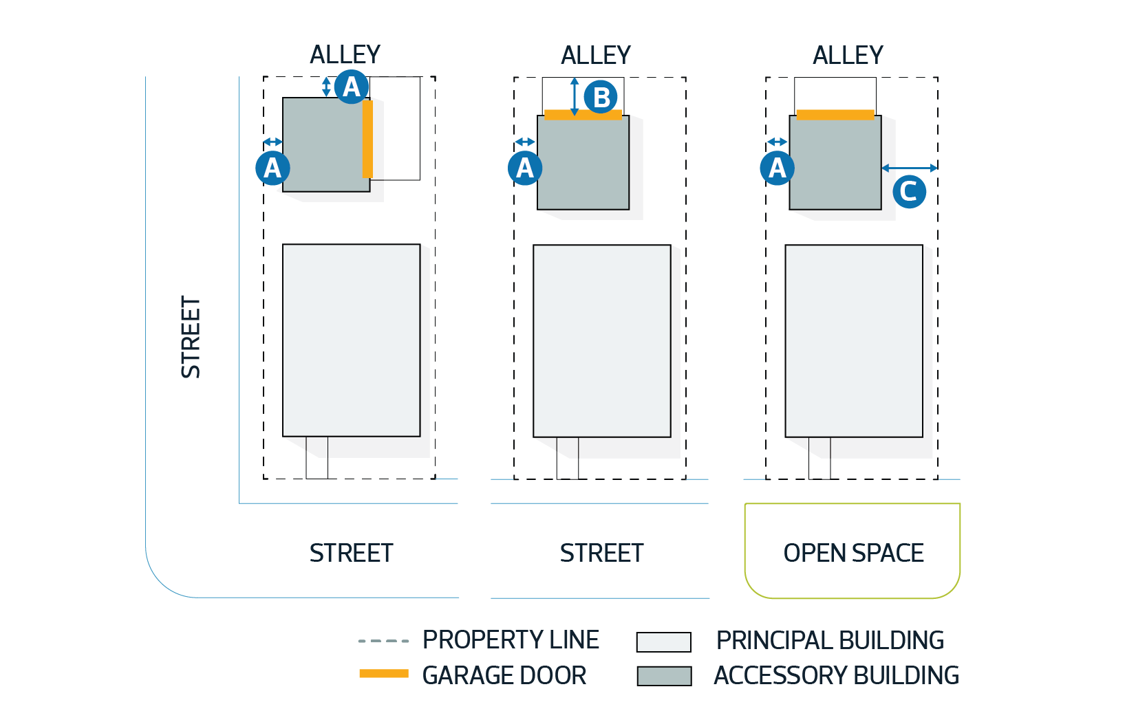
Accessory Building means a Building that is incidental and subordinate to a Principal Use or Principal Building on the same Lot and is more than 10.0 m2 (107.6 ft2) in area or 2.0 m (6.5 ft.) in height.
4.1.3. Accessory Development means a Use or Building that is incidental and subordinate to a Principal Use or Principal Building located on the same Lot.
4.1.4. Adjacent Land means land that is contiguous to a Lot of land that is subject of a Development or Subdivision application and includes land that would be contiguous if not for a public roadway, highway, river or stream, or reserve Lot. 
4.1.5. Agricultural Operation means an agricultural activity conducted on agricultural land for gain or reward or in the hope or expectation of gain or reward and includes Agriculture, Extensive; Agriculture, Horticultural and Agriculture, Livestock. This does not include Cannabis or any Cannabis related Uses.
4.1.6. Agricultural Processing, Limited means on-site processing of the products from an Agricultural Operation for distribution or sale, but does not include an Abattoir or the processing of the products from any other Agricultural Operation. This does not include Cannabis or any Cannabis related Uses.
4.1.7. Agriculture, Extensive means a system of tillage which depends upon large areas of land for raising crops and includes Buildings and structures incidental to farming.
4.1.8. Agriculture, Horticultural means a growing operation that, due to its nature, May require smaller tracts of land and includes Buildings and structures incidental to farming. Without restricting the generality of the foregoing, this land use category May include Uses such as a plant nursery, Market Garden, tree farm and specialty crop production, but not a Commercial Greenhouse. This does not include Cannabis or any Cannabis related Uses.
4.1.9. Agriculture, Livestock means an Agricultural Operation that involves keeping of Livestock where the number or density of animals on the subject Lot is less than the threshold which requires approval by the Natural Resources Conservation Board as a confined feeding operation and includes Buildings and structures incidental to farming.
4.1.10. Amenity Space means generally green space and planting which softens the urban fabric, allows for informal leisure, and provides a setting for Buildings.
4.1.11. Amusement Entertainment Services means a Lot or Building used for providing entertainment and amusement to patrons, usually for a fee or admission charge. Typical Uses and facilities would include a go-cart track, miniature golf course, carnival, circus, table or electronic games establishment, amusement theme-park and drive-in motion picture theatre.
4.1.12. Animal Care Service means a facility such as a hospital or shelter used for the temporary accommodation, care, treatment or impoundment of animals. This would include such Uses as Veterinary Clinics, animal training and grooming facilities. 
4.1.13. Applicant means the registered owner of land or persons authorized by the registered owner to act as representative or agent. 
4.1.14. Automotive Sales and Service means the retail sale, rental of new or used automobiles, trucks, motorcycles, and Recreational Vehicles, together with incidental maintenance services and sales of parts, but does not include major Equipment Sales and Service.
4.1.15. Automotive and Equipment Body Repair means a facility where automobiles, trucks, other vehicles and equipment undergo body repair, sandblasting and/or painting.
4.1.16. Automotive and Equipment Repair means a facility for: 
 
4.1.16.1. the servicing and mechanical repair of automobiles, trucks and utility vehicles, motorcycles, snowmobiles, motor homes and similar vehicles; 
4.1.16.2. the sale, installation, or servicing of related accessories and parts; and 
4.1.16.3. servicing and repair of small engines and equipment; but 
4.1.16.4. does not include auto body repair, paint shops, or wrecking yards.
4.1.17. Bicycle Parking Space means an area set aside for the parking of 1 bicycle.
4.1.18. Broadcast Film Studio means a facility used for the production, recording and/or broadcasting of presentations typically associated with radio, television and motion pictures.
4.1.19. Building Area means the area of land covered by a Building and measured between the exterior surfaces of the outer walls of the Building.
4.1.20. Building Grade means, for the purposes of determining Building height to implement this Bylaw, the average level of finished ground adjacent to the front of the Building, excluding any localized depressions. 
4.1.21. Building means anything constructed or placed on, in, over or under land but does not include a highway or public roadway or a bridge forming part of a highway or public roadway. 
4.1.22. Bulk Oil Sales means a facility used for the bulk storage and distribution of petroleum products and May include card-lock retail sales.
4.1.23. Business Office means a Building or part of a Building used primarily for clerical, managerial or administrative functions and May include: 
 
4.1.23.1. the use of minor mechanical equipment for printing, duplicating, binding or photographic processing; 
4.1.23.2. secretarial services; 
4.1.23.3. Professional, Scientific and Technical Services; 
4.1.23.4. Information Services; 
4.1.23.5. office maintenance or custodial services; 
4.1.23.6. office security; and 
4.1.23.7. the sale, rental, repair, or servicing of office equipment.
4.1.24. Campground means Development of land for temporary placement of holiday trailers, motor homes, tents, campers and similar accommodations for short term occupancy, together with such necessary facilities as washroom, laundry and camp shop, to meet the needs of campground users.
4.1.25. Cannabis Accessory Store means a retail store unlicensed by the Province of Alberta where Cannabis Accessories are sold at the premises and does not include the sale of any Cannabis.
4.1.26. Cannabis Accessory means Cannabis accessory as defined in the Cannabis Act (Canada) and its regulations, as amended from time to time and includes, but is not limited to; rolling papers or wraps, holders, pipes, water pipes, bongs, vaporizers, or anything that is deemed to be used in the consumption of Cannabis.
4.1.27. Cannabis Production Facility means an enclosed Building, licensed by the Federal Government, where Cannabis is grown for distribution (for medical or private retail purposes), and typically includes the cultivating, propagating and/or harvesting of the Cannabis plant. Other processes May include the packaging, shipping, testing and storage of Cannabis and Cannabis related products.
4.1.28. Cannabis Retail Store means a retail store licensed by the Province of Alberta where Cannabis (and May include Cannabis Accessories) are sold at the premises. 
4.1.29. Cannabis Storage and Distribution Facility means an enclosed Building, licensed by the Provincial Government, where Cannabis is stored, but not grown (for medical or private retail purposes), and May include processes such as the packaging, shipping, storage and distribution of Cannabis and Cannabis related products. 
4.1.30. Cannabis means Cannabis plant, fresh Cannabis, dried Cannabis, Cannabis oil and Cannabis plant seeds and any other substance defined as Cannabis in the Cannabis Act (Canada) and its regulations, as amended from time to time, and includes edible products that contain Cannabis. This excludes Industrial Hemp licensed or exempt by the federal government under the Industrial Hemp Regulations (or other applicable Acts or regulations at the time of application. 
4.1.31. Casino/Gambling Establishment means a facility licensed by Alberta Gaming and Liquor, where the principal activity is gaming with the chance of monetary loss or gain through playing such games. Types of gaming May include card or other table games, video lottery terminals, slot machines, or other electronic or mechanical gambling devices. Accessory Development May include  Restaurants, Drinking Establishments and Commercial Retail Services.
4.1.32. Cemetery means land that is used for the burial of human or animal remains and May include such Developments as memorial parks, burial grounds and mausoleums.
4.1.33. Child Care Facility means Buildings and lands used for the provision of care, instruction, maintenance or supervision of 7 or more children by a person other than one related by blood or marriage, for periods not exceeding 24 consecutive hours and includes all day-care centres, early childhood services, nurseries and after-school or baby-sitting programs which meet this definition.
4.1.34. Commercial Greenhouse means a facility used to raise, display and sell plants within an enclosed structure and May include sales of related gardening or plant-care products as a minor component.
4.1.35. Commercial Retail Service means the retail sale or rental of consumer goods and services to the general public. Heavy equipment sales or rentals and Liquor Sales are not included within this definition.
4.1.36. Commercial Storage means a Building or group of Buildings in which rentable space is provided for the storage of goods of a non-hazardous nature.
4.1.37. Contractor Service, General means a service of a major construction nature that requires Outdoor Storage and warehouse space. Any sales, display, office or technical support service areas Shall be accessory to the principal general contractor service Use only.
4.1.38. Contractor Service, Indoor means a construction related service such as electrical, plumbing, heating, painting and Landscaping primarily to individual Landowners but May also service other businesses, and May include the limited sale of goods normally accessory to the service. Outdoor Storage of equipment is not permitted and commercial vehicles kept on the premises Shall be of a maximum of 1 Ton or smaller.  
4.1.39. Convenience Retail Service means the retail sale of goods to area residents and employees on a day to day basis, from Buildings not exceeding 275 m2 (2,960 ft2) in total gross Floor Area. Typical Uses include small food stores, drug stores and variety stores. Liquor Sales and Gas Bars are not included within this definition.
4.1.40. 
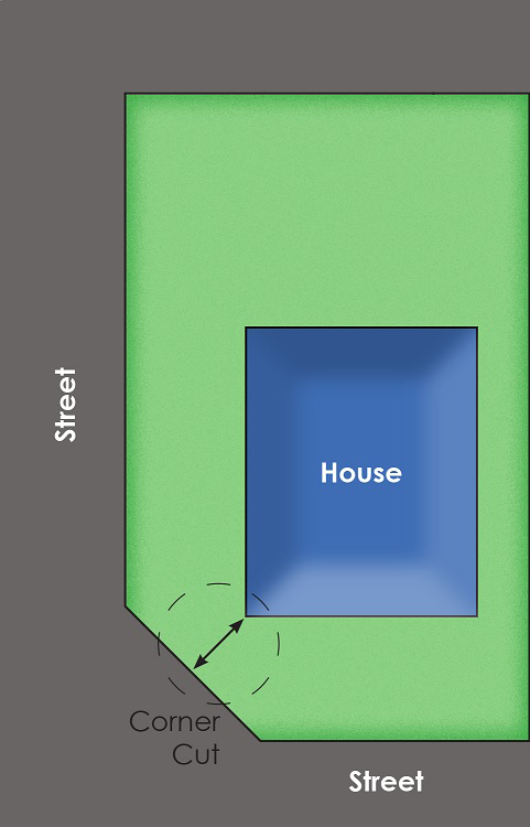
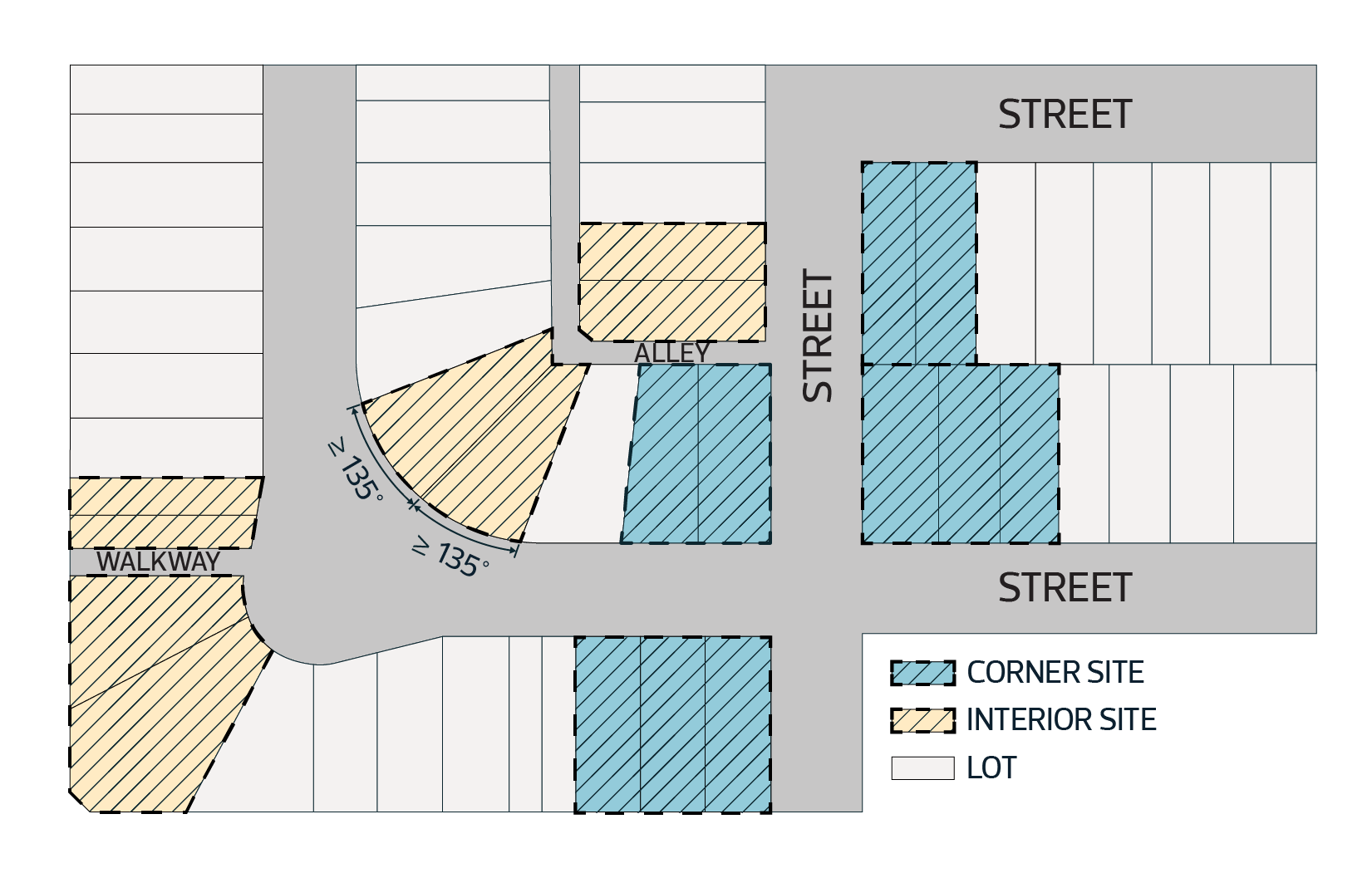
Corner Lot means a Lot that abuts a road on 2 sides that intersect with each other.
4.1.41. Cultural Facility means a Development used for the collection and/or appreciation of literary, artistic, musical, historical, scientific, natural and similar reference materials, or a Building intended for live theatrical, musical or dance performances. Typical facilities would include libraries, museums, art galleries, auditoriums, theatres and concert halls.
4.1.42. Development Permit means a document or permit, which May include attachments, issued pursuant to this Bylaw authorizing a Development. 
4.1.43. Development means:
 
4.1.43.1. an excavation filling or stockpile and the creation of them; or
4.1.43.2. a Building or an addition to, or replacement or repair of a Building and the construction or placing in, on, over or under land of any of them; or
4.1.43.3. a change of Use of land or a Building or an act done in relation to land or a Building that results in or is likely to result in a change in the Use of the land or Building; or
4.1.43.4. a change in the intensity of use of land or a Building or an act done in relation to land or a Building that results in or is likely to result in a change in the intensity of use of the land or Building.
4.1.44. Directional Sign means a Sign providing directions to a facility which May not be located on the same Site as the Sign, and does not include any advertising of products or services. 
4.1.45. Discretionary Use means the use of land or a Building provided for in the Bylaw for which a Development Permit May be issued, with or without conditions, by the Development Planner upon application having been received by the City.
4.1.46. Distribution Facility means a Building for the storage and/or distribution of goods and May include the temporary storage of Motor Vehicle, Commercial (i.e. trucks and tractor trailers) for freight handling including the pick-up, delivery and transitory storage of goods incidental to motor freight shipment.
4.1.47. Double Fronting Lot means a Lot that abuts a road on 2 sides that do not intersect.
4.1.48. Drinking Establishment means a commercial facility, licensed by the Alberta Gaming and Liquor Commission, in which alcoholic beverages are served for consumption on the premises, and includes a licensed lounge that is ancillary to a Restaurant.
4.1.49. Drive-In Food Services means a Development used for eating and drinking, which offers a limited menu produced in a manner that allows rapid customer service and includes one or more of the following features: 
 
4.1.49.1. car-attendant services;
4.1.49.2. drive-through food pick-up services; or 
4.1.49.3. parking primarily intended for on-site consumption of food within a motor vehicle or within the Building which contains limited amount of seating.
4.1.50. Dwelling means a self-contained Building or part of a Building used for human habitation and usually containing living, sleeping, cooking, eating and sanitary facilities for a single Household.
4.1.51. Dwelling, Communal means an arrangement of Dwellings as an integral part of an agricultural, educational, recreational or religious facility operated by a recognized communal organization.
4.1.52. Dwelling, Custodial Suite means a Dwelling within a non-residential Building and intended for use by persons employed to provide on-site security and/or maintenance of land, Buildings, animals or equipment.
4.1.53. Dwelling, Detached means a Dwelling that is separate from other Buildings and constructed or assembled on Site upon a permanent foundation and includes a Dwelling, Modular.
4.1.54. Dwelling, Manufactured Home means a factory constructed transportable single or multiple section detached Dwelling conforming to the CAN/CSA A277 or CAN/CSA Z240 MH series certified standards at the time of manufacture designed with a steel frame substructure, and is ready for residential occupancy upon completion of set-up in compliance with required factory recommended installation instructions including placement on a foundation and hook up to utilities.
4.1.55. Dwelling, Modular means a finished factory constructed single or multiple section Dwelling, Detached designed with a wood frame substructure intended to be relocated in modules or as a single unit, assembled and placed on a permanent foundation. Finished means fully enclosed on the exterior and interior but May not include interior painting, taping, and installation of cabinets, floor covering, fixtures, heating system, and exterior finishes.
4.1.56. Dwelling, Moved In means a Dwelling, Detached that was constructed at a location other than the Lot on which it is to be placed for use as a Dwelling.
4.1.57. Dwelling, Principal means the Dwelling determined by the Development Planner to be primary for the purpose of assigning secondary status to an additional Dwelling under Edmonton South Special Area.
4.1.58. Dwelling, Secondary means an additional Dwelling that is ancillary to a Dwelling, Principal on the same Lot, and May include a Garden Suite, Secondary Suite, Manufactured Home or Custodial Suite.
4.1.59. Education Service means a service involving the assembly of persons for educational, training or instruction purposes and May include related administrative offices, and dormitories and Accessory Buildings. Typical facilities include public and separate schools, private schools or seminaries, community colleges, universities, technical and vocational facilities.
4.1.60. Environmental Impact means an adverse effect on the use or enjoyment of an area due to noise, odour, illumination, dust, smoke, vibration, hazardous or dangerous emission or material, visual appearance or any other elements deemed relevant by the Development Planner.
4.1.61. Environmentally Sensitive Area means:
 
4.1.61.1. hazardous lands and areas that are unsuitable for Development in their natural state (i.e. floodplains, steep and unstable slopes);
4.1.61.2. areas that perform a vital environmental, ecological or hydrological function (i.e. aquifer or recharge groundwater storage areas);
4.1.61.3. areas that contain unique geological or physiological features;
4.1.61.4. areas, Buildings or features that are important for cultural, historical, prehistoric or archeological reasons;
4.1.61.5. areas that contain significant rare or endangered animal or plant species;
4.1.61.6. areas containing unique habitats with limited representation in the region or small remnants of previously abundant habitats which have virtually disappeared;
4.1.61.7. areas that contain large, relatively undisturbed habitats and provide shelter for species that are intolerant of human disturbance; and
4.1.61.8. areas that provide an important link for the natural migration of wildlife. 
4.1.62. Equestrian Facility means a facility used for the training of horses and riders and May include facilities for horse boarding and grooming, horse shows and equestrian competitions.
4.1.63. Equipment Sales and Service means a facility used for the sale, rental, service, or repair of heavy vehicles, machinery or mechanical equipment typically used in Building, roadway, pipeline, oil field and mining construction, manufacturing, assembling and processing operations, and agricultural production.
4.1.64. Fence means a vertical physical barrier constructed to prevent visual intrusions, unauthorized access, or to provide sound abatement.
4.1.65. Financial Service means a service related to money management and investment typically provided by a bank, trust company, investment dealer, credit union, mortgage broker or related business, and May include rapid customer service such as a drive-through.
4.1.66. Floor Area means the total horizontal area of all floors of a Building above Building Grade, and including in the case of a bi-level or split-level Building a floor level less than 1.2 m below Building Grade, within the outside surface of exterior walls and the centreline of fire walls but not including attached Garages, basements, decks, patios, driveways, sidewalks, open porches or breezeways.
4.1.67. Frame and Fabric Structure means a Building designed and constructed with a rigid frame that supports an exterior fabric covering and May also include some rigid exterior wall panels containing windows and/or doors.
4.1.68. Freestanding Sign means a Sign permanently fixed to the ground independent of a Building or other structure.
4.1.69. 
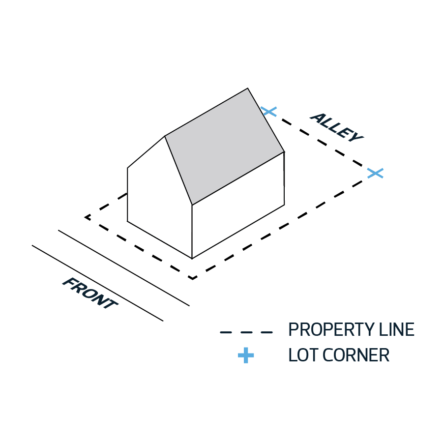
Front Yard means that portion of the Lot extending across the full width of a Lot from the front property line to the nearest portion of the Building.
4.1.70. Funeral Service means a facility used for the preparation of the dead for burial, the purification and reduction of the human body by heat and the keeping of bodies other than in a Cemetery and the holding of associated services. Typical Uses include: 
 
4.1.70.1. funeral homes; 
4.1.70.2. crematoriums; and 
4.1.70.3. mausoleums.
4.1.71. Garage means an accessory Building or part of the Principal Building, designed and used primarily for the storage of motor vehicles.
4.1.72. Gas Bar means a facility used for the sale of motor fuel, lubricating oils, automotive fluids, and associated convenience store products. The Gas Bar May be a self-service, full service, key lock, card lock, or other similar operation and May include a vehicle-washing facility as an Accessory Use but does not provide auto repair or servicing.
4.1.73. Group Home means a Dwelling that is recognized, authorized, licensed or certified as a social care facility by a relevant government authority, to provide room and board for persons with physical, mental, social or behavioural problems living together as a single Household of more than 6 members, which May include resident staff. Group homes Shall not include substance abuse treatment centres, boarding and lodging houses, temporary shelter services or detention and correction services. 
4.1.74. Group Home, Limited means a Dwelling that is recognized, authorized, licensed or certified as a  social care facility by a relevant government authority to provide room and board to persons with physical, mental, social or behavioural problems living together as a single Household of no more than 6 members including resident staff. Limited Group Homes Shall not include substance abuse treatment centres, boarding, lodging houses or temporary shelter services and detention and correction services.
4.1.75. Guest House means all or part of an accessory Building which has sleeping accommodation, and May have sanitary services but which does not have cooking facilities and is not intended to be used as a self-contained Dwelling unit. Sleeping accommodation above a detached Garage Shall be deemed to be a Guest House.
4.1.76. Home Based Business Type 1 means a secondary use of an occupied principal Dwelling by the permanent residents of the Dwelling to conduct a business, which does not change the character of the Dwelling or present any exterior evidence of such activity and does not involve client visits.
4.1.77. Home Based Business Type 2 means a secondary use of an occupied principal Dwelling and/or its accessory Buildings by at least 1 permanent resident of the Dwelling. The business May involve client visits at the discretion of the Development Planner and no more than 1 commercial vehicle on-site (maximum 1 ton weight). 
4.1.78. Home Based Business Type 3 means a secondary use of an occupied principal Dwelling, its accessory Buildings and Site, or a combination thereof, by at least 1 permanent resident of the Dwelling, to conduct a business. The business May include some outdoor activity, some non-resident employees at the discretion of the Development Planner (maximum 3), client visits at the Development Planner’s discretion, and a maximum of 2 commercial vehicles. 
4.1.79. Hotel means a commercial Development that provides rooms or suites for temporary sleeping accommodation with access from a common interior corridor and that May include accessory food services, licensed Drinking Establishments, entertainment facilities, meeting rooms, personal service establishments and Commercial Retail Services. 
4.1.80. Household means a person or a group of persons living together as a single housekeeping group and using cooking facilities shared in common, and May also include domestic or personal care staff. 
4.1.81. Industrial Hemp means, as defined by the Industrial Hemp Regulations, Cannabis plants and plant parts, of any variety, that contains 0.3% tetrahydrocannabinol (THC) or less in the leaves and flowering heads. 
4.1.82. Industrial, Light means an indoor industrial or manufacturing activity which, in the opinion of the Development Planner, cannot be detected (noise, glare, vibration or airborne emissions) from outside of the Building that houses the operation, and May involve altering, assembling, fabricating, finishing, inspecting, making, processing, producing, treating or repairing, items either by hand or through the use of machinery. Industrial, Light May include the temporary storage of onsite motor vehicle, commercial for freight handling including pick-up, delivery and transitory storage of goods incidental to motor freight shipment directly related to the permitted Use. In certain Zones, Industrial, Light May include small areas of Outdoor Storage (actual availability and area provided for Outdoor Storage to be outlined within applicable Edmonton South Special Area Zone regulations). Industrial, Light May include small format retail accessory to the Principal Use.
4.1.83. Infilling means the placement of natural uncontaminated earth or aggregate materials (i.e. clay, silt, sand, gravel) on a Lot to alter drainage grades or to build up a Site for a proposed Building or Development, but does not include placement of dry-waste or land fill waste materials.
4.1.84 Information Service means a facility engaged in producing and distributing information in a digital or printed format and includes data processing, library services and archives, publishing and printing services.
4.1.85 Institutional Use means public administration and service, and May include libraries, museums, auditoriums, schools, colleges, hospitals, protective and emergency services, and other government and community activities as determined by the Development Planner.
4.1.86 Kennel means a facility used primarily for the breeding, boarding, caring or training of dogs and May include other Small Animal Breeding and Boarding Services.
4.1.87 Labour Group Housing means a facility to provide limited-term accommodation for persons employed on a specific work project on or near the facility and May include Manufactured Homes, Recreational Vehicles and holiday trailers.
4.1.88 Landowner means the current assessed owner(s) of a Lot as shown in the assessment files of the City.
4.1.89 Landscaping Element, Hard means an impermeable Landscaping element such as, but not limited to, ceramic, brick, wood, concrete, or marble. Fences, decorative walls, fountains, and ornaments are also considered as Hard Landscaping Elements.
4.1.90 Landscaping Element, Soft means vegetation adapted to the Alberta climate such as, but not limited to, grass, flowering plants, Shrubs, and trees. A rock garden incorporating vegetative elements is also considered a Soft Landscaping Element.
4.1.91 Landscaping Sales and Service means the use of lands, Buildings or structures, or part thereof, for the purpose of selling soft Landscaping materials such as seeds, plants, trees and Shrubs, as well as hard Landscaping materials such as rocks, pavers, ornaments, shale, crushed rock or other similar materials associated with Landscaping.
4.1.92 Landscaping means the incorporation, preservation, or enhancement of vegetation and other materials on a Site which are intended to improve the aesthetic appeal of the Site, contribute to the character of a neighbourhood, and/or harmonize the Site with its surrounding natural environment.
4.1.93 Liquor Sales means the wholesale or retail sale or distribution to the public of any and all types of alcoholic spirits or beverages as defined by the Alberta Liquor Control Act.
4.1.94 Livestock means cattle, swine, poultry, sheep, goats, horses, game and similar animals.
4.1.95 Local Community Facility means a facility provided by a municipality, group or organization without profit for recreational, social or cultural purposes and intended primarily for the use of the local area residents.
4.1.96 Lot means a quarter section; a river Lot or a settlement Lot shown on an official plan registered in a Land Titles Office; or part of a parcel of land described in a certificate of title.
4.1.97 Manufactured Home Sales and Service means Development used for the display, sale or rental of new or used Manufactured Homes and includes the provision of maintenance services and sale of parts and accessories.
4.1.98 Manufacturing, Light means a facility used for indoor processing, assembly and packaging of goods using innovative or advanced technology, a highly skilled work force and having no adverse Environmental Impact with respect to noise, glare, vibration or airborne emissions, and May include indoor storage and display of materials and products.
4.1.99 Manufacturing, Limited Indoor means a facility used for small scale on-site indoor production of goods by hand; manufacturing primarily involving the use of hand tools and fewer than 5 production employees. Typical Uses include, but are not limited to:
 
4.1.99.1. jewelry, toy and musical instrument manufacturing;
4.1.99.2. gunsmiths; and
4.1.99.3. pottery and sculpture studios.
4.1.100. Market Garden means a facility where plants such as flowers, herbs, fruits and vegetables are cultivated in greenhouses or outdoor garden plots and sold on-site to the general public.
4.1.101. May is an operative word that means a choice is available, with no particular direction or guidance intended.
4.1.102. Motel means a commercial Development that provides self-contained rooms or suites for temporary sleeping accommodation with or without kitchen facilities, where each room or suite has its own sanitary facilities and an exterior access. A Motel May include accessory food services, meeting rooms and personal service establishments.
4.1.103. Multi-Lot Residential Subdivision means a Subdivision of land, registered by plan of survey or descriptive plan containing 4 or more contiguous Lots where the Lots have been created for, or are being principally used for, residential purposes.
4.1.104. Natural Resource Extraction means the removal of natural resources (excluding oil and gas), including peat, timber and wood fibre, metallic and non-metallic minerals (such as sand, gravel, coal, limestone, gypsum, granite and salt). Typical facilities or uses would include:
 
4.1.104.1. gravel pits, sand pits, clay or marl pits;
4.1.104.2. peat extraction;
4.1.104.3. stripping of topsoil; and
4.1.104.4. commercial tree clearing.
4.1.105. Night Club means a Building or part thereof used primarily for the provision of pre-recorded music or/and live musical entertainment for listening and/or dancing by the patrons, and/or the provision of live comedic entertainment for patrons, and whose secondary function is the sale and consumption on the premises of food and alcoholic beverages (to be licensed by the Alberta Gaming and Liquor Commission). This operation is only open to the public between the hours of 17h30 and 02h00.
4.1.106. Outdoor Storage means the accessory storage of equipment, goods, and materials in the open air where such storage of goods and materials does not involve the use of permanent structures or the material alteration of the existing state of the land.
4.1.107. Park means land specifically developed or reserved for active or passive public recreational use and includes natural and man-made Landscaping, playing fields, infrastructure, and Buildings that are consistent with the general purposes of the land. Typical Uses include tot-lots, band shells, picnic grounds, pedestrian trails and paths, landscaped buffers, playgrounds and water features.
4.1.108. 
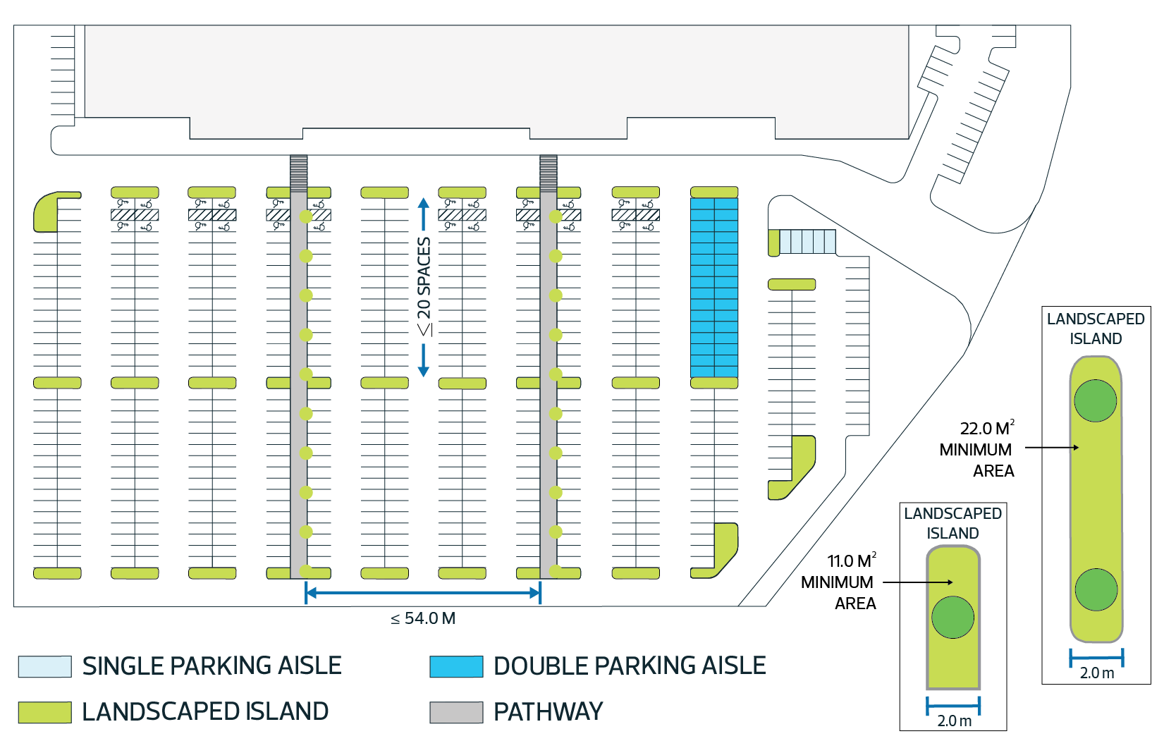
Parking Court means a portion of a parking Lot which generally includes one or more access aisles & parking stalls, and May include bioswales, landscaped boulevards, sidewalks or pathways, lighting, and other elements.
4.1.109. Parking Facility means the area set aside for the storage and parking of vehicles that includes one or more Parking Courts, used to service a Development, a group of Developments accessible within a walking distance, or enable the users to access a mode of transportation other than a private vehicle, and whereas the owner and/or the operator May require at his own discretion, a fee or an admission charge.
4.1.110. 
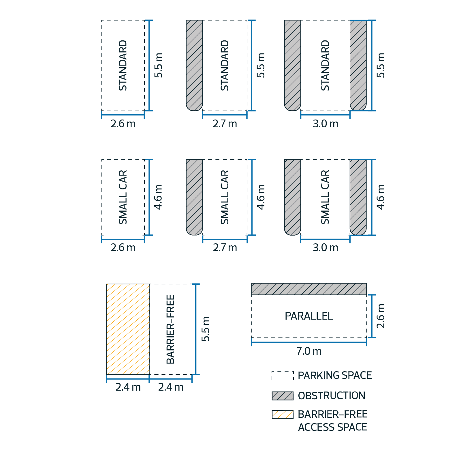
Parking Space means an area set aside for the parking of 1 motor vehicle.
4.1.111. Passive Recreation means outdoor recreational pursuits that generally do not require significant infrastructure or facility Development and are quiet and peaceful in character. Typical Uses include nature studies, bird watching, picnicking, fishing, walking and similar activities that do not significantly disturb the natural environment.
4.1.112. Permitted Use means the use of land or a Building provided for in the Bylaw for which a Development Permit Shall be issued, with or without conditions, by the Development Planner upon application having been received by the City.
4.1.113. Personal and Health Care Service means the provision of a personal aesthetic or grooming service; or physical or mental health service of a preventative, diagnostic or therapeutic nature. Typical facilities would include:
 
4.1.113.1. hair salons and barbershops;
4.1.113.2. medical and dental offices;
4.1.113.3. health clinics;
4.1.113.4. counseling services;
4.1.113.5. fitness centres; and
4.1.113.6. chiropractic offices.
4.1.114. Principal Building means a Building which:
 
4.1.114.1. occupies the major or central portion of a Site,
4.1.114.2. is the chief or main Building among one or more Buildings on the Site, or
4.1.114.3. constitutes by reason of its use the primary purpose of the Site.
4.1.115. Principal Use means the primary purpose for which a Building or Site is used. There Shall be no more than 1 Principal Use on a Lot unless specifically permitted in Special Area Edmonton South.
4.1.116. Professional, Scientific, and Technical Service means a facility that provides services that require a high degree of expertise and training. Services May include: 
 
4.1.116.1. legal advice and representation;
4.1.116.2. accounting, bookkeeping, and payroll services;
4.1.116.3. architectural, engineering, and specialized design services;
4.1.116.4. computer services;
4.1.116.5. consulting services;
4.1.116.6. research services;
4.1.116.7. advertising services;
4.1.116.8. photographic services;
4.1.116.9. translation and interpretation services; and
4.1.116.10. other similar activities.
4.1.117. Protective and Emergency Service means a facility providing protection of persons and property from injury, harm, or damage, together with incidental storage of emergency equipment which is necessary for the distribution of services. Typical Uses include police, fire and ambulance stations.
4.1.118. Province means the Province of Alberta and includes all Ministries and Departments within the Government of Alberta.
4.1.119. Rear Yard means that portion of the Lot extending across the full width of the Lot from the rear property line to the nearest portion of the Building.
4.1.120. Recreation, Indoor means a facility where patrons participate in sports events and other recreational activities in an enclosed Building that May include Accessory Restaurants and Commercial Retail Services. Typical Uses include but are not limited to, arenas, athletic clubs, health and fitness clubs, gymnasiums, swimming pools, rifle and pistol ranges, bowling alleys, and racquet clubs.
4.1.121. Recreation, Outdoor means a facility where patrons participate in sports and other outdoor recreational activities and it May include Accessory Restaurants and Commercial Retail Services. Typical Uses include golf courses, driving ranges, ski hills, tennis courts, swimming pools, waterslides, sports fields, equestrian trails, boating facilities and recreational trails.
4.1.122. Recreational Lot means a Lot intended for recreational Development as Principal Use.
4.1.123. Recreational Vehicle Storage means a facility used for the storage of Recreational Vehicles including but not limited to motor homes, travel trailers, fifth wheels, truck campers, tent trailers, or similar vehicles.
4.1.124. Recreational Vehicle means a motor vehicle or structure attached to a motor vehicle that is designed to provide mobile living accommodations and includes a travel trailer, truck camper, tent trailer, fifth wheel and motor home.
4.1.125. Recycling Depot means a facility used for sorting, storage and distribution of bottles, cans, tetra- packs, newspapers, cardboard, plastics and similar Household goods for reuse.
4.1.126. Recycling Depot, Indoor means a facility used for sorting, storage and distribution of bottles, cans, tetra-packs, newspapers, cardboard, plastics and similar Household goods for reuse, and whereas all material and goods are contained within the Building.
4.1.127. Religious Assembly means a facility operated by a recognized religious organization for worship and related religious, philanthropic or social activities and includes accessory rectories, manses, meeting rooms, classrooms, dormitories and other Buildings. Typical facilities include churches, chapels, mosques, temples, synagogues, parish halls, convents and monasteries.
4.1.128. Residential Lot means a Lot intended for residential Development as Principal Use.
4.1.129. Restaurant means a facility primarily intended for the preparation and sale of foods and beverages to the public for consumption on or off the Site. This use typically has a varied menu, with a fully equipped kitchen and preparation area.
4.1.130. Retail Store, Large Format means a Building or part thereof, in which goods are offered for sale, lease and/or rental to consumers. Where the primary function of the retail store is the sale of food, food May be prepared on the premises and offered for sale to the public for consumption on the premises or off the premises. Retail Store, Large Format, Buildings Shall have a gross Floor Area greater than 930 m2 (10,000 ft2). Typical Uses include, but are not limited to, warehouse retail, outlet stores and large-scale grocery stores. This Use excludes the sale, lease and/or rental of motor vehicles and commercial motor vehicles.
4.1.131. Road, Arterial means a road designed for high volumes of traffic with uninterrupted flow, which provides connectivity between a collector road and a freeway with no direct access to Lots.
4.1.132. Road, Highway means a road designated by the Province as a Highway
4.1.133. Road, Internal means a public roadway, not designated as a Road, Municipal Grid, providing direct access to Lots within a registered multi-lot Subdivision.
4.1.134. Road, Lane means rear access roads that act as a secondary vehicle network in urban and suburban areas.
4.1.135. Road, Municipal Grid means a Township or Range Road.
4.1.136. Road, Service means a public road adjacent to a Road, Highway, providing direct road access to Lots adjacent to the highway.
4.1.137. School, Commercial means a Building of part thereof, where specialized instruction is provided for the financial gain of the individual or company owning the school, and includes, but is not limited to, a business school, a trade school, a driving school, a dance school, a music school, a fine arts school, a martial arts school, language/cultural school, or a tutoring school.
4.1.138. Screening means a structure, berm, or planting used to visually obscure a Development Site from Adjacent Lands.
4.1.139. Seasonal Sign means a Sign erected for a limited period of time every year in the same location and providing the same general information to advertise a seasonal activity such as a plant nursery.
4.1.140. Security Suite means a Dwelling, Custodial Suite, Manufactured Home, holiday trailer, or motor home no larger than 55.7 m2 (600 ft2) used to provide on-site accommodation for security personnel during working shifts and not to be used as a permanent residence.
4.1.141. Service Station, Major means a facility used for the servicing, washing, or repairing of vehicles; and the sale of gasoline, other petroleum products, and vehicle parts and accessories. A Major Service Station May include a Restaurant, Convenience Retail Services and specialty food services. Typical Uses include truck stops and highway service stations.
4.1.142. Service Station, Minor means a facility used for the routine repair, servicing or washing of vehicles within a building containing up to three (3) service bays; and for the sale of gasoline, petroleum products, and a limited range of automotive parts and accessories and may include convenience retail services.
4.1.143. Setback means the perpendicular distance to a Development from an adjacent natural or man-made feature, such as an escarpment, road, or property line.
4.1.144. Shall is an operative word that means the action is obligatory.
4.1.145. Shrub means a horticultural rather than strictly botanical category of woody plant that has a spread and/or height greater than 30.48 cm (1.0 ft.), distinguished from a tree by its multiple stems and lower height, usually less than 5.0-6.0 m (15.0-20.0 ft.) tall.
4.1.146. Side Yard means that portion of the Lot extending from the Front Yard to the Rear Yard and lying between the side property line and the nearest portion of the Building.
4.1.147. 
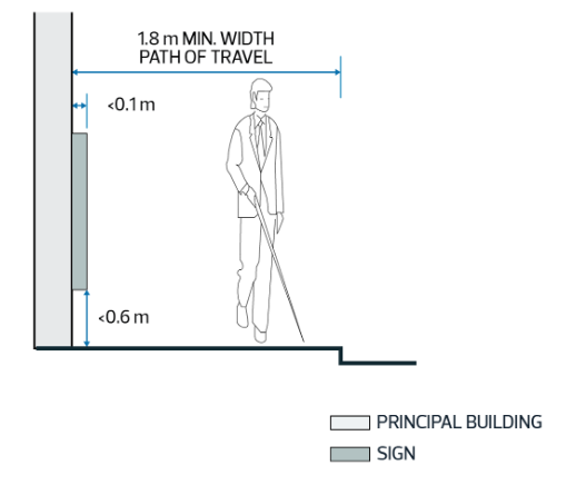
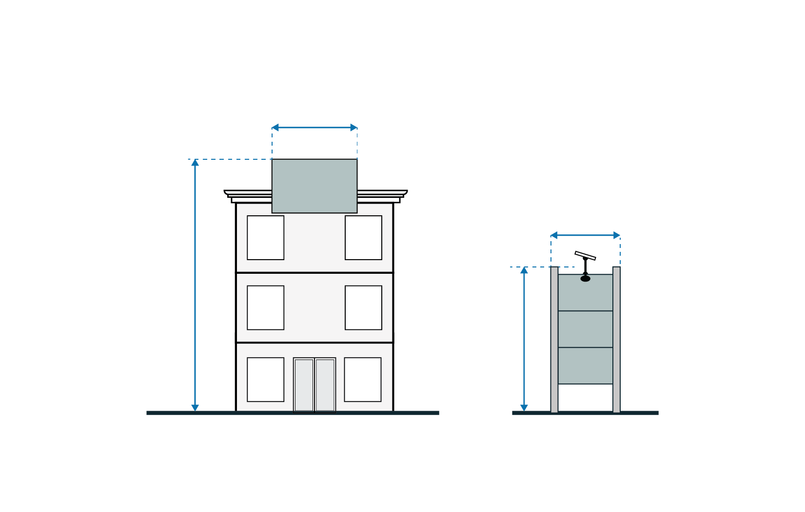
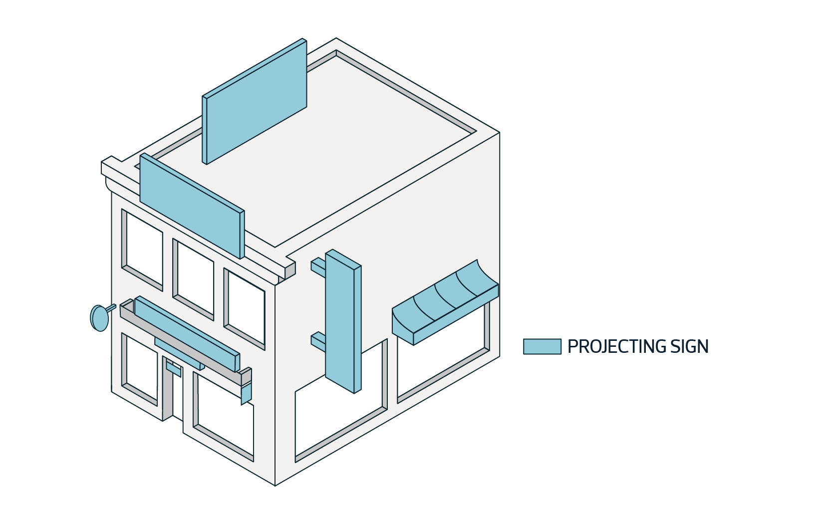
Sign means an object or device intended for the purpose of advertising or calling attention to any person, matter, thing or event.
4.1.148. Site means an area of land consisting of 1 or more adjacent Lots.
4.1.149. Small Animal Breeding and Boarding Service means a facility for breeding, boarding, caring or training of small animals other than dogs, and normally considered as Household pets.
4.1.150. Stockpiling means the short to long term accumulation of goods, aggregates, soils, clays or similar materials, on a specified property, usually accumulated as a result of earthworks or to accommodate Development.
4.1.151. Streetscape means the space between the Buildings on either side of a street that defines its character. The elements of a Streetscape include Building Frontage/facade, Landscaping (trees, yards, bushes, plantings, etc.), sidewalks, street paving, street furniture (benches, kiosks, trash receptacles, fountains, etc.), Signs, awnings, and street lighting.
4.1.152. Subdivision means division of a Lot by an instrument. (“subdivide” has a corresponding meaning).
4.1.153. Temporary Asphalt Plant means a facility used for the purpose of producing and distributing asphalt cement products, located on a Site for a period not exceeding 8 months.
4.1.154. Temporary Sign means a Sign erected for a specified period of time announcing or advertising an event of limited duration.
4.1.155. Top Of Bank means the upper natural topographical break that signifies the upper edge of the slope to a watercourse or water body.
4.1.156. Truck Terminal means a Building or part thereof, where trucks and/or tractor trailers are dispatched for hire as common carriers for pick-up, delivery, and transitory storage of goods incidental to motor freight shipment.
4.1.157. Truck Weigh Scale means a large scale structure that is usually mounted permanently on a concrete foundation that is used to weigh entire vehicles (motor vehicle, commercial) and their contents. By weighing the vehicle both empty and when loaded the load carried by the vehicle can be calculated. Truck Weight Scale May be accessory to a Dwelling, Custodial Suite.
4.1.158. Utility Service, Major means Development for utility infrastructure purposes which, in the opinion of the Development Planner, is likely to have a major Environmental Impact. Typical Uses include, but are not limited to:
 
4.1.158.1. sewage treatment plants;
4.1.158.2. water treatment plants;
4.1.158.3. major pump houses;
4.1.158.4. water towers or tanks;
4.1.158.5. sewage lagoons;
4.1.158.6. snow dumping Sites;
4.1.158.7. sludge disposal beds;
4.1.158.8. garbage transfer and compacting stations;
4.1.158.9. power terminal and distributing stations;
4.1.158.10. power generating stations;
4.1.158.11. cooling plants;
4.1.158.12. equipment and material storage yards for vehicles, utilities and services;
4.1.158.13. district heating plants;
4.1.158.14. incinerators; and
4.1.158.15. waste recycling plants.
4.1.159. Utility Service, Minor means Development for utility infrastructure purposes which, in the opinion of the Development Planner, is likely to have only minor Environmental Impact. Typical Uses in this class include, but are not limited to, works used to provide water, sewage disposal, irrigation, drainage, fuel, telephone, electric power, waste management, public transportation, or street lighting for public benefit, convenience, or use.
4.1.160. Vehicle Storage means Outdoor Storage or indoor storage of vehicles that are not directly associated with the Principal Use of the Lot on which they are being stored.
4.1.161. Veterinary Clinic means a facility for the medical care and treatment of small animals and includes provision for their overnight accommodation but does not include outdoor pens, runs or enclosures.
4.1.162. Warehouse Sales means a facility used for the wholesale or retail sale of a limited range of goods from within an enclosed Building where the size and nature of the principal goods being sold typically requires a large Floor Area for storage and display. Typical uses include, but are not limited to, sales of furniture, carpets, major appliances, and Building materials. This Use does not include the retail sale of food or of a broad range of goods for personal or Household use.
4.1.163. Warehousing and Storage, Indoor means the use of a Building primarily for the keeping of goods and merchandise, excluding dangerous or hazardous materials, derelict vehicles or any waste material, and whereas all goods and merchandises are contained within the Building.
4.1.164. Warehousing and Storage, Limited means the use of a Building or a portion of a Site primarily for the keeping of goods and merchandise, excluding dangerous or hazardous materials, derelict vehicles or any waste material.
4.1.165. Wholesaling Facility means a Building or part thereof where the purpose of the business is buying goods for resale to other employment, commercial, institutional, or agricultural business users including other wholesalers.
4.1.166. Wildland means an area of uncultivated land that is primarily covered with trees, bushes or wild grasses and left in a natural or near natural state.


5.1. Accessory Development - Accessory Development Shall comply with the following regulations:
 
5.1.1. An Accessory Building Shall be considered as a Permitted Use where it is accessory to a Permitted Use and as a Discretionary Use where it is accessory to a Discretionary Use.
5.1.2. Despite Subsection 5.1.1, an Accessory Building exceeding the maximum area prescribed as a Permitted Use in the Zone regulations Shall be considered discretionary.
5.1.3. An Accessory Building Shall not be used as a Dwelling unless specifically approved for that purpose either as accessory to a non-residential Development, or as an additional Dwelling on a residential Site.
5.1.4. An Accessory Building Shall not be permitted to locate within an easement.
5.1.5. Despite Subsection 5.1.4, the Development Planner May issue a permit for a movable Accessory Building to be located within an easement, provided the permit includes a condition ensuring that, at the request of the City, the structure will be removed at the sole cost of the Landowner.
5.1.6. Where another Building is attached to the Principal Building on a Site by a roof, common wall or foundation, it is considered as part of the Principal Building and not an Accessory Building.
5.2. Airport Vicinity Protection Area
 
5.2.1. The Development Authority Shall not approve a Development permit application for any land within an Airport Vicinity Protection Area unless the Development complies with the applicable regulations made under Section 693(1) of the Municipal Government Act.
5.2.2. Airport Vicinity Protection Area Regulations May be amended only by application to the Province.
5.3. Design and Appearance of Development
 
5.3.1. Proposed Development within or adjacent to a Multi-lot Residential Subdivision, Shall be designed, constructed and maintained to the satisfaction of the Development Planner with respect to its appearance, including but not limited to:
 
5.3.1.1. Rooflines, facades and exterior finishes;
5.3.1.2. Satellite dishes, radio antennas, exterior lights, Signs and other such equipment;
5.3.1.3. Outdoor Storage areas and garbage enclosures;
5.3.1.4. Parking Lots and Internal Roadways;
5.3.1.5. Fencing and Landscaping;
5.3.1.6. Other factors deemed relevant by the Development Planner.
5.3.2. When reviewing the design and appearance of a Development, the Development Planner Shall consider the quality and durability of finishing materials, aesthetic compatibility with surrounding Development, visual impacts on roadways and other public areas, Site security, public safety, and any other factors deemed to be relevant.
5.3.3. When reviewing the design and appearance of a Development, the Development Planner May solicit input from neighbouring Developments, government departments and agencies, industry representatives, and any other relevant source.
5.3.4. The Development Planner and Subdivision Authority Shall apply all design standards and requirements as outlined in Edmonton South Special Area.
5.3.5. Streetscapes Shall be designed, constructed and maintained to the satisfaction of the Development Planner and/or the Subdivision Authority and must meet all City standards. Streetscapes in some Zones May have additional requirements to ensure that they are pedestrian friendly and adequately furnished, providing a safe focal point for all users to interact and socialize.
5.3.6. In a multifamily residential Development, the design of each Site Shall ensure architectural compatibility of structures such that the principal design elements, finishing materials, colours and roof style Shall be applied to each Building with appropriate variations.
5.4. Environmental Considerations
 
5.4.1. On a Lot adjacent to the North Saskatchewan River Valley a minimum Setback of 50.0 m (164.0 ft) from the Top Of Bank to any Development Shall be required to reduce Environmental Impacts and manage risk.
5.4.2. Further to Subsection 5.4.1, on a Lot adjacent to any other permanent water body a minimum 20.0 m (65.6 ft) Setback Shall be required between the Top Of Bank and any Development.
5.4.3. On a Lot adjacent to a slope of 15% (8.3° ) or greater, or any slope which in the opinion of the Development Planner might be unstable, a geotechnical assessment by a professional engineer May be required in order to evaluate stability, and to recommend appropriate Development Setbacks, consistent with provincial guidelines.
5.4.4. Despite Subsections 5.4.1, 5.4.2, and 5.4.3, if the Development Planner is satisfied by the submission of a professional environmental and/or geotechnical assessment that the variance of a Setback is warranted, the Setback May be increased or reduced accordingly.
5.4.5. Within the minimum Setback as required by Subsections 5.4.1 and 5.4.2, land disturbance and the removal of trees or vegetation Shall be minimized to reduce environmental effects and the risk of property damage.
5.4.6. The Development Planner Shall not approve a permanent Building within the 1:100 year floodplain of any watercourse.
5.4.7. The Development Planner May approve a permanent Building within the 1:100 year flood-fringe subject to flood-proofing to mitigate potential damage and indemnification of the City from potential liability.
5.4.8. The Development Planner May require an Applicant to submit environmental reports, to the satisfaction of the Development Planner, for Development in or near an Environmentally Sensitive Area as part of the Development Permit application.
5.4.9. When considering Development involving land in or adjacent to an Environmentally Sensitive Area, the Development Authority May refer the application to federal or provincial departments and other relevant environmental agencies for comments prior to reaching a decision. A Development Permit issued for a Permitted or Discretionary Use within an Environmentally Sensitive Area May include conditions for meeting specific environmental objectives determined by the Development Planner, including those identified in comments provided by federal or provincial departments and other relevant environmental agencies. Such conditions May include, but are not limited to:
 
5.4.9.1. restrictions on Site clearing and grading;
5.4.9.2. additional Setback requirements;
5.4.9.3. retention of shelterbelts;
5.4.9.4. Fencing;
5.4.9.5. siting and standards of Buildings;
5.4.9.6. emission controls; and
5.4.9.7. buffering requirements.
5.4.10. Removal of natural vegetation and alterations to the natural drainage of lands within or adjacent to an Environmentally Sensitive Area Shall be discouraged.
5.5. Landscaping
 
5.5.1. The Development Planner May require the Applicant of a proposed Development to provide decorative Landscaping on the Site as a condition of approval.
5.5.2. Where a Development proposes the removal of 1 or more trees, the Development Planner May require a report from a certified arborist prior to removal.
5.5.3. The Development Planner May require an application for a Development Permit to be accompanied by a Landscaping plan prepared by a specialist or group of specialists. At the discretion of the Development Planner, approval of the Landscaping plan May be required prior to issuance of the Development Permit or as a condition of Development Permit approval. For the purposes of this section, a specialist is a professional:
 
5.5.3.1. Engineer;
5.5.3.2. Architect;
5.5.3.3. landscape architect;
5.5.3.4. agronomist; or
5.5.3.5. person having, according to the Development Planner, the equivalent experience and skills as an individual listed above.
5.5.4. Where a Landscaping plan is required, the plan Shall include the following:
 
5.5.4.1. boundaries and dimensions of the Site;
5.5.4.2. keymap describing Adjacent Land Uses, their boundaries and dimensions;
5.5.4.3. location of adjacent sidewalks, pathways, driveway entrances, easements, right-of-ways, and laneways;
5.5.4.4. location and name of adjacent streets;
5.5.4.5. footprint and dimensions for all Buildings;
5.5.4.6. location, grade, and description of any sound mitigation measures if such measures are required or proposed;
5.5.4.7. all existing berms, contours, walls, Fences, outdoor and street furniture, lighting, and decorative paving;
5.5.4.8. location of all existing plant materials to be retained; and
5.5.4.9. location and description or illustrations of all proposed hard and soft Landscaping Elements.
5.5.5. Landscaping May include hard elements such as decorative rock, brick, ceramic, wood and/or concrete; and soft elements such as grass, trees, Shrubs and/or flower gardens. Earthen berms, ponds, ornaments, decorative walls, and Fences May also be incorporated into Landscaping designs. Other Landscaping elements May be accepted by the Development Planner, especially where Landscaping is done according to a specific theme.
5.5.6. For the purposes of Edmonton South Special Area, a tree or Shrub Shall be:
 
5.5.6.1. structurally sound, well-balanced, healthy and vigorous;
5.5.6.2. of normal growth habits; and
5.5.6.3. densely foliated when in leaf, with a healthy, well developed root system.
5.5.7. For the purpose of Landscaping requirements as required in Edmonton South Special Area, a Landscaping element is considered to be:
 
5.5.7.1. a deciduous tree having a minimum trunk caliper of 50.0 mm (2.0 in.) measured at 0.5 m (1.6 ft) above grade;
5.5.7.2. a coniferous tree having a minimum height of 2.0 m (6.5 ft.) above grade;
5.5.7.3. a group of 3 Shrubs;
5.5.7.4. a vine exceeding 2.0 m in length;
5.5.7.5. a flower bed covering a minimum area of 2.0 m2 (21.5 ft2);
5.5.7.6. a lawn covering the entirety of a Site excepting Building footprints and areas reserved for the maneuvering and/or storage of vehicles or areas occupied by other Landscaping elements as required by Edmonton South Special Area; or
5.5.7.7. a combination of hard elements covering an area of 2.0 m2 (21.5 ft2) or greater, but not including areas reserved for vehicle maneuvering.
5.5.8. Landscaping Shall not include:
 
5.5.8.1. toxic or dangerous materials and/or substances; or,
5.5.8.2. materials, devices, components, and elements that May constitute a health or safety hazard.   
5.5.9. Vegetation used for Landscaping Shall be located such that it will grow to maturity without causing negative impacts to adjacent properties and/or public infrastructure.
5.5.10. Where a Landscaping plan is required, the requirements for the number of elements May be varied at the discretion of the Development Planner provided that existing elements are incorporated into the Landscaping plan.
5.5.11. Where the required number of elements is a fractional number, it Shall be rounded down if below 0.5 and rounded up if equal to or greater than 0.5. When calculating this requirement, the Lot area required for primary or Accessory Buildings Shall not be included in the calculation.
5.5.12. Where a Development does not include a Building, Landscaping requirements for the Front Yard Shall be applied to the entire Lot area.
5.5.13. The owner of the property, or his/her successor or assignees, Shall be responsible for the maintenance of Landscaping to the satisfaction of the Development Planner and in concordance with any drainage plan affecting the property. If a Landscaping element does not survive a 2 year maintenance period, the Applicant must replace it with a similar species type of comparable caliper width.
5.5.14. At the time of Subdivision, or as a condition of a Development Permit, an irrevocable letter of credit May be required, up to a value of 125% of the estimated cost of the proposed Landscaping to ensure that the Landscaping is carried out with reasonable diligence. The condition of the security Shall be that the Landscaping Shall be completed in compliance with Edmonton South Special Area regulations and the plan within 1 growing season after the completion of the Development. If the Landscaping does not survive the 2 year maintenance period specified in Subsection 5.5.13, the amount fixed Shall be paid to the City for the City to replace the Landscaping.
5.5.15. Landscaping plans addressing Streetscape, Screening, and/or nuisance mitigation shall be approved by the Development Planner prior to approval of a Development Permit.
5.5.16. Despite the requirements for Landscaping and/or Screening in each Edmonton South Special Area Zone, Landscaping and/or Screening shall be required for all non-agricultural Development within the Highway 2 corridor in compliance with the provisions of the Highway 2 Corridor Design Guidelines.
5.5.17. A Site used for a multi-unit residential or row housing Development Shall provide an Amenity Space within a year of construction completion for the active or Passive Recreation and enjoyment of the occupants of the Development. The Amenity Space May consist of a single landscaped communal area or the Amenity Space May be divided into private, individual Amenity Space adjacent to, and for the private use of, each residential Dwelling unit, or some combination thereof.
5.6. Lighting
 
5.6.1. Outdoor lighting on a Site Shall be located and designed so as to not interfere with the use and enjoyment of neighbouring properties, or with the safe and effective use of public roadways.
5.6.2. The maximum permitted height for a freestanding light pole is 9.0 m (29.5 ft.) above Building Grade unless otherwise determined by the Development Planner who Shall have regard for the scale and character of adjacent Development and any matters of aesthetics or public safety considered to be relevant.
5.7. Lot Requirements
 
5.7.1. In all Edmonton South Special Area Zones, a Development Permit for a Discretionary Use Shall not be approved unless, in the opinion of the Development Planner, the Lot is suitable for the proposed Development.
5.7.2. When determining the suitability of a Lot for Development, the Development Planner Shall consider the following elements:
 
5.7.2.1. Lot size;
5.7.2.2. topography and natural features;
5.7.2.3. availability of potable water;
5.7.2.4. method of sewage disposal;
5.7.2.5. Site drainage;
5.7.2.6. road access;
5.7.2.7. Environmental Impacts; and
5.7.2.8. any other Site-related factors considered to be relevant.
5.7.3. Where not prescribed in Section 3.60, 3.61, 3.62, 3.63, 3.64, 3.65, 3.66, 3.67, or 3.68, the minimum Lot size for a proposed Development Shall be determined by the Development Planner, taking into account the Setback requirements of the Zone, requirements for on-site sewage disposal and parking, and where specified, the minimum Floor Area required for the Development.
5.8. Parking and Loading
 
5.8.1. All Development, including Building additions and changes in the Use or intensity of Use on a Site Shall be required to provide on-site parking in compliance with Schedule 1 of Edmonton South Special Area.
5.8.2. The minimum number of on-site Parking Spaces required for each Use of a Building or Development Shall be in compliance with Schedule 1:
Schedule 1 Edmonton South Special Area: On Site Parking Requirements
Use of Building or Site Minimum Number of on-site Parking Spaces Required
Residential
Dwelling, Principal 2 per Dwelling
Dwelling, Secondary 1 per Dwelling*
Apartment Dwelling 1.5 per Dwelling (for 1 or 2 bedroom Dwelling) or 2 per Dwelling (3 bedrooms or more) + 1 per 7 Dwellings for visitors
Townhouse Dwelling 2 per Dwelling
Guest House 1 per Dwelling*
Group Home 1 per 2 employee*
Home Based Businesses 1 per non-resident employee**
Bed and Breakfast 1 per guest unit*
* In addition to the number of spaces required for the Principal Dwelling.
**In addition to the number of spaces required for the Principal Dwelling as well as any commercial vehicles associated with the Home Based Business.
Commercial
Business Offices 1 per 30.0 m2 (323 ft2) of GFA*
Medical and/or dental offices or clinics 4 per doctor or dentist
Retail and service shops with GFA below 2000 m2 1 per 45.0 m2 (484  ft2) of GFA
Retail and service shops with a GFA 2000 m2 to 20,000 m2 1 per 30.0 m2 (323  ft2) of GFA
Retail/service shops with GFA more than 20,000 m2 1 per 25.0 m2 (269  ft2) of GFA
Restaurants
Drinking Establishments
the greater of 1 per 4.0 seats or 1 per 10.0 m2 (108  ft2) of GFA
Drive-in Restaurants 1 per 2.8 m2 (30  ft2) used by patrons
Automotive repair and services
auto body shops
tire shops
2 per service bay
Hotels
Motels
1 per guest room, + 1 per three employees on maximum shift, +1 per 4 seats of any associated eating or Drinking Establishment
* Gross Floor Area
Industrial
Manufacturing plants
General Industrial
Warehousing and Storage yards
servicing and repair establishments
research laboratories
public utility Buildings
1 per 100.0 m2 (1076  ft2) of GFA up to 2000 m2 + 0.5 per extra 100 m2
Auction marts
Outdoor Storage yards
Determined by Development Planner
Places of Assembly
Private clubs
Cultural Facilities
Religious Assemblies
recreation centres and other
amusement or recreational
establishments
the greater of 1 per 5 seats or 1 per 10.0 m2 (108 ft2) of GFA used by patrons
Exhibition and Convention Facility 1 per 5 fixed seating spaces + 1 per 10.0 m2 of area used by patrons
Golf Course 4 Parking Spaces per hole + parking for associated users as required by the Edmonton South Special Area regulations
Schools
Elementary and Junior High Schools the greater of 2 per classroom or 1 per 10 students
Senior High Schools the greater of 5 per classroom or 1 per 5 students
Post-secondary and other college- type facilities as determined by Development Planner
 
5.8.3. Where a Use is not specified in Subsection 5.8.2, the number of stalls provided Shall be the same as for a similar Use as determined by the Development Planner.
5.8.4. Where a Development on a Lot includes more than 1 Use, the required number of spaces Shall be the sum of the requirements for each of the Uses as specified in Subsection 5.8.2 unless it can be shown to the satisfaction of the Development Planner that Parking Spaces May be shared between Uses with different hours of operation.
5.8.5. Where a fractional number of Parking Spaces are required by this Bylaw, the next highest number of stalls Shall be provided.
5.8.6. All required on-site Parking Spaces Shall be provided on the Lot served by the parking unless arrangements have been made to the satisfaction of the Development Planner, to provide such parking on another Lot. If another Lot is to be used, the parking Shall be located within 150.0 m (492.1 ft.) of the Use they are intended for, and a safe and secure connection must be provided between the parking area and the Use.
5.8.7. Where permitted in Zone Regulations, on-site parking within a Front Yard or flanking Side Yard Shall be incorporated into a Landscaping plan and screened to the satisfaction of the Development Planner.
5.8.8. A Parking Space Shall be rectangular with a minimum width of 2.6 m (8.5 ft.) and length of 5.5 m (18 ft.), and minimum vertical clearance of 2.0 m (6.5 ft.).
5.8.9. Despite Subsection 5.8.8, where parallel Parking Spaces are provided, each internal space Shall be increased to a minimum length of 7.0 m (23.0 ft.).
5.8.10. Aisles within on-site parking area Shall have a minimum width of 7.5 m (25.0 ft.) for 90° parking, 7.0 m (23.0 ft.) for 75° parking, 5.5 m (18.0 ft.) for 60° parking and 3.6 m (12.0 ft.) for 45° parking or parallel parking.
5.8.11. Included within the required number of Parking Spaces for a Development, sufficient public Parking Spaces for the disabled Shall be provided in compliance with the requirements of the applicable Building code.
5.8.12. Where a merchandise and/or material loading area is required as part of a Development, it Shall be provided entirely within the Lot boundaries to the satisfaction of the Development Planner.
5.8.13. Where a passenger loading area is required as part of a Development, it Shall be:
 
5.8.13.1. located as close as reasonably possible from an entry to the Building;
5.8.13.2. located in such a manner as not to interfere with any required space for emergency vehicles;
5.8.13.3. not less than 5.0 m in width; and
5.8.13.4. not less than 6.0 m in length.
5.8.14. Where a certain number of Parking Spaces are required for a Use under Subsection 5.8.2 the Development Planner May relax the number of on-site vehicle Parking Spaces required if bicycle parking is provided on-site to the satisfaction of the Development Planner.
5.9. Pipeline Setbacks
 
5.9.1. Development Setbacks from pipeline rights-of-way, oil and gas installations and other utility corridors Shall meet or exceed the requirements of the Province.
5.9.2. Subject to Subsection 5.9.1, for the following Uses, the minimum Setback from the right-of-way of a pipeline with a maximum licensed operating pressure of 3447.5KPa or greater is:
 
5.9.2.1. 1.0 m (3.3 ft.) for an Accessory Building
5.9.2.2. 15.0 m (50.0 ft.) for a principal residential, commercial or industrial Building; and
5.9.2.3. 200 m (656 ft.) for a Principal Building for sensitive Uses including but not limited to community recreation services, private education, public education, spectator entertainment, exhibition and convention facilities, major health services, Religious Assemblies, or spectator sports.
5.9.3. The minimum Setback from a pipeline with a maximum licensed operating pressure less than 3447.5KPa is 5.0 m (16.0 ft.) for all Principal Buildings.
5.10. Protection of Agricultural Operations
 
5.10.1. Within an Edmonton South Special Area Zone where an Agricultural Operation is listed as a Permitted Use, the City Shall endeavor to protect such Agricultural Operations from any undue pressures that May arise due to nearby non-agricultural Development.
5.10.2. Where more than 1 minimum Setback distance is applicable under Edmonton South Special Area, the greater distance Shall prevail.
5.11. Site Leveling, Infilling, Grading and Stockpiling
 
5.11.1. No topsoil, fill, aggregate or other similar material Shall be deposited on, moved within, or removed from a property without first obtaining a Development Permit, unless specifically exempt under Section 7.120.
5.11.2. Any application made for Site leveling, Infilling, grading or Stockpiling under Subsection 5.11 Shall be processed as a Discretionary Use in all Edmonton South Special Area Zones, unless specifically exempt under Section 7.120.
5.11.3. Where a Development Site requires leveling, Infilling or grading, the topsoil on the Site Shall be removed, Stockpiled, and replaced following completion of the Site modifications.
5.11.4. Any Development Permit application that involves importing material from outside of the subject property to which the application is being considered, Shall include the following, as an integral part of the application:
5.11.5. Soil Testing, in compliance with Subsection 5.11.13;
5.11.6. A detailed description of the source of the material being considered for the Development Permit (eg. legal land location, Site map, aerial imagery);
5.11.7. detailed description of the reason(s) for making the application (eg. Infilling for construction purposes; to increase agricultural productivity; flood control); and
5.11.8. Any other supporting information deemed necessary by the City to protect agricultural crop land from harmful contaminants.
5.11.9. Should any works undertaken under the provisions of Subsection 5.11 require the removal of any materials from the subject Site, a disposal plan providing an overview of the means of disposal for any surplus topsoil or material Shall be required at the time of application.
5.11.10. Site grading Shall not be permitted to direct additional surface drainage from the subject Lot onto an adjacent Lot unless provided for in an approved drainage plan or storm water management plan for the area.
5.11.11. Site grading Shall not be permitted to impede or interfere with the natural flow of surface water onto Adjacent Lands or public ditches.
5.11.12. Despite Subsection 5.11.11, where provincial approval to divert a natural water course has been obtained, a Development Permit May be issued for Lot grading or Site Development that includes the approved diversion.
5.11.13. Materials used for Infilling, grading or Stockpiling on a Site Shall be free of contaminants and debris to the satisfaction of the Development Planner and the Province (where applicable). If in the opinion of the Development Planner there is a risk of contaminants or debris, the Development Planner May require an Applicant to submit, prior to approval being issued, professional testing to ensure that all materials are free of Agricultural Soil Borne Pests (including, but not limited to Clubroot of Canola) that May be of detriment to the Development Site, or surrounding areas in compliance with Subsection 5.11.12.
5.11.14. Proposals for the Stockpiling of materials sourced from outside of the property, in which the Development Permit is being considered, Shall be determined at the discretion of the Development Planner. The Stockpiling of any materials that do not form an implicit part of a wider Development proposal, that, in the opinion of the Development Planner, will create visual detriment to the surrounding area, Shall not be permitted.
5.11.15. Should any proposed Infilling or grading works be for the provision of future Development, it Shall be the responsibility of the Applicant to demonstrate to the City, at the Development Permit stage, that the material being imported to the Development Site provides adequate ground stability for the intended Use.
5.12. Tree Clearing
 
5.12.1. Tree clearing is considered to be a Discretionary Use in all Edmonton South Special Area Zones, and Shall require a Development Permit unless exempted by this Bylaw. Tree farms and the clearing of land for agricultural Developments are exempted.
5.12.2. For the purposes of Edmonton South Special Area, tree clearing does not include commercial logging operations which are considered to be a Natural Resource Extraction industry.
5.12.3. As part of an application for tree clearing, an Applicant Shall be required to provide the following information:
 
5.12.3.1. reasons for the proposed tree clearing;
5.12.3.2. a description of the vegetation to be cleared;
5.12.3.3. a Site plan with dimensions showing the area to be cleared and any significant natural features on and adjacent to the area to be cleared;
5.12.3.4. a proposed schedule for tree clearing and hauling;
5.12.3.5. the proposed access and haul routes for removing timber; and
5.12.3.6. plans for Site restoration.
5.12.4. When considering an application for tree clearing, the Development Planner Shall have regard for the environmental significance of the area to be cleared and the potential impacts on Adjacent Lands.
5.13. Wildfire Provisions
 
5.13.1. When evaluating a Development application in or adjacent to Wildlands, the Development Authority Shall refer the application to Edmonton Fire Rescue Services for their review and comments with respect to fire safety.
5.13.2. As part of a Development application in or adjacent to Wildlands, an Applicant May be required to provide the following information:
 
5.13.2.1. a description of all vegetation on the Site;
5.13.2.2. a Site plan with dimensions showing all combustible materials on the Site, including Buildings, decks, Fences, firewood storage, trees and brush;
5.13.2.3. a description of the exterior Building materials on all Buildings;
5.13.2.4. a contour drawing of the Site;
5.13.2.5. a description of any fire pit, burning barrel or chimney outlet and its location relative to combustible materials;
5.13.2.6. a description of any propane, gasoline or diesel oil storage and its location on the Site; and
5.13.2.7. the location of overhead power lines on the Site.
5.13.3. As part of a Development application in or adjacent to Wildlands, the Development Planner May require a wildfire hazard assessment.
5.13.4. As a condition of approval for a Development in or adjacent to Wildlands, the Development Planner May require that actions be taken to reduce the risk of wildfire, including the removal of natural vegetation and other combustible materials on the Site and the use of non-combustible materials on the exterior of Buildings.
5.13.5. Despite any other provision of the Edmonton South Special Area regulation, the minimum Setbacks for a Building situated adjacent to a Wildland May be increased, in compliance with recommendations of the Alberta Fire Smart Program, in order to provide an adequate defensible space around the Building in the event of wildfire.
5.14. Front Yard
 
5.14.1. In the case of a Corner Lot, the Front Yard Shall be the narrower of the 2 frontages unless otherwise determined by the Development Planner.
5.14.2. Where a corner Site comprises more than 1 Lot, the Front Yard of the entire Site Shall be taken on the same frontage as the Corner Lot.
5.14.3. The Development Planner May require a Double Fronting Lot to provide Front Yard Setbacks on each road to improve the Streetscape appearance and achieve Setback consistency with Development on adjacent properties.
5.14.4. Where a Lot is both a Corner Lot and a Double Fronting Lot, the Development Planner Shall determine which frontages Shall be considered the Front Yard for purposes of Building orientation and Setback.
5.15. Screening and Fencing
 
5.15.1. Screening May be required by the Development Planner to minimize the impact of elements considered to be unsightly.
5.15.2. The Landowner Shall be responsible for the maintenance of Screening and/or Fencing to the satisfaction of the Development Planner.
5.15.3. Screening elements Shall be unobtrusive and aesthetically pleasing, with a size and height considered appropriate by the Development Planner, unless otherwise specified in a Zone with specific Screening requirements.
5.16. Projections into Yards
 
5.16.1. Structures erected and equipment installed to ensure barrier-free access to a Development or Building, and which are projecting into a required Yard, May be approved by the Development Planner, provided that the projection meets the provisions of the Alberta Building Code.
5.16.2. Utilities, underground parking, and similar structures constructed entirely beneath the surface of the ground May encroach into required yards provided such underground encroachments do not result in a grade inconsistent with abutting properties and the encroachments are covered by sufficient soil depth or surface treatment to foster Landscaping.
5.17. Campground
 
5.17.1. Where considering an application for Development of a Campground whether consisting of campsites or Recreational Lots, the Development Planner Shall have regard for the suitability of the Site based on its physical attributes, accessibility, surrounding land uses and environmental sensitivity.
5.17.2. A Campground Shall not be permitted within 305 m (1,000 ft.) of a Multi-Lot Residential Subdivision. Exceptions May be made where a highway bisects the minimum separation distance.
5.17.3. An application for a Campground Shall include a detailed plan showing natural contours and vegetation, vehicle and pedestrian circulation systems, children’s play areas, utilities, Buildings, service areas and proposed campsites to the satisfaction of the Development Planner.
5.17.4. The number and layout of campsites or Recreational Lots in a Campground Shall be to the satisfaction of the Development Planner who Shall consider environmental sensitivity, privacy of campers, potential impact on roads, Adjacent Land uses, public recreation facilities and other factors considered relevant.
5.18. Child Care Facility
 
5.18.1. When considering an application for the Development of a Child Care Facility the Development Planner Shall take into account the size, configuration and quality of the Site and associated Buildings, Adjacent Land uses, potential traffic generation, proximity to Parks, open spaces or recreation areas, and potential impacts on other Development in the surrounding area.
5.18.2. The Development Planner May consult with provincial and municipal child service agencies prior to making a decision.
5.18.3. A Child Care Facility Shall provide, to the satisfaction of the Development Planner, a minimum of 1 on-site Parking Space for every 3.0 m2 of Floor Area as defined by Provincial childcare regulations, as amended from time to time.
5.19. Dwelling, Garden Suite
 
5.19.1. A Dwelling, Garden Suite May be approved on a Lot of 0.8 ha (2.0 ac) or more if, in the opinion of Development Planner, it would not interfere with the existing quality of life or character of the neighbourhood.
5.19.2. A Dwelling, Garden Suite shall be located and designed to connect with utilities serving the host residence and shall not jeopardize services to neighbouring Lots. If a proposed garden suite cannot practically be connected with the water or sewer utility on the Site, it May be permitted to have a pump-out holding tank for sewage and/or a cistern for a potable water supply.
5.19.3. A Dwelling, Garden Suite shall be designed, constructed, and finished in a manner that is, in the opinion of the Development Planner, visually compatible with the principal on the Site and the general Development of the neighbourhood.
5.19.4. The gross Floor Area of a garden suite shall be no less than 37.2 m2 (400 ft2) and no more than 65 m2 (700 ft2).
5.19.5. The maximum height of a garden suite shall be no more than 4.5 m (14.7 ft.).
5.19.6. A garden suite shall comply with the minimum Setback requirements of the district.
5.19.7. The Site around a garden suite shall be graded to minimize pooling under or around the suite and to avoid storm water runoff onto adjacent Lots.
5.19.8. A permit issued for a garden suite shall be temporary, for a term not exceeding 5 years, and May be renewed upon subsequent application. Upon expiry of the permit, and if it is not renewed, the suite shall be removed or incorporated into the Dwelling, principal and the Site restored to the satisfaction of the Development Planner.
5.20. Dwelling, Manufactured Home
 
5.20.1. A Dwelling, Manufactured Home Shall have C.S.A. certification, or an equivalent to the satisfaction of the Development Planner, to be submitted with the Development Permit application.
5.20.2. A Dwelling, Manufactured Home Shall be placed on a proper foundation in compliance with Alberta Building Code Regulations. The foundation Shall be temporary where a Dwelling, Manufactured Home is limited to a temporary approval as a Dwelling, Secondary under Subsection 5.22.9.
5.20.3. The undercarriage of a Dwelling, Manufactured Home Shall be completely screened from view by a foundation, skirting or structural addition to the satisfaction of the Development Planner.
5.20.4. The design, construction and appearance of all steps, porches, decks and additions Shall be of a standard that is compatible with that of the Dwelling, Manufactured Home.
5.21. Dwelling, Moved-In
 
5.21.1. In any Edmonton South Special Area Zone allowing residential Uses, a previously owned Dwelling, Detached moved onto an existing Lot Shall be considered a Dwelling, Moved-In and is a Discretionary Use.
5.21.2. A Dwelling, Moved-In Shall not be approved unless, in the opinion of the Development Planner, the Building is designed, constructed, and finished in a manner that is visually compatible with existing Development in the neighbourhood.
5.21.3. As a condition of Development approval, the Development Planner May require a letter of agreement and a security from the Applicant to ensure the satisfactory completion of any required Site work, construction, or finishing of a Dwelling, Moved-in.


5.22. Dwelling, Secondary
 
5.22.1. A Dwelling, Secondary May include a Dwelling, Detached, Dwelling, Garden Suite, Dwelling, Secondary Suite, Dwelling, Custodial Suite or Dwelling, Manufactured Home as defined and regulated in Edmonton South Special Area.
5.22.2. Where permitted in Edmonton South Special Area Zone regulations, a Dwelling, Secondary Shall be approved on a Lot of 32.4 ha (80.0 ac) or greater provided it complies with the regulations of Edmonton South Special Area.
5.22.3. Despite Subsection 5.22.2, a Lot that is slightly less than 32.4 ha (80.0 ac) due to the provision of land for a road widening, utility Lot or similar Use May be considered to be the same as a 32.4 ha (80.0 ac) Lot for the purposes of this section.
5.22.4. On a Lot 32.4 ha (80.0 ac) or greater, where there are already 2 Dwellings, Principal and a Dwelling, Secondary, an additional Dwelling, Secondary Shall be limited to a Dwelling, Garden Suite, Dwelling, Secondary Suite or Dwelling, Custodial Suite.
5.22.5. On a Lot between 0.8 ha (2.0 ac) and 32.4 ha (80.0 ac) in area, a Dwelling, Secondary May be approved subject to the following conditions:
 
5.22.5.1. On a Lot less than 2.0 ha (4.9 ac) a Dwelling, Secondary Shall be limited to a Dwelling, Garden Suite, or Dwelling, Secondary Suite, only;
5.22.5.2. On a Lot between 2.0 ha(4.9ac) and 32.4ha (80), Dwelling, Secondary Shall not include a Dwelling, Detached; but May include a Dwelling, Manufactured Home; a Dwelling, Garden Suite; or Dwelling, Custodial Suite on a discretionary basis.
5.22.6. Despite Subsection 5.22.5, on any Full-Serviced Residential Lot a Dwelling, Secondary Suite May be approved subject to such conditions as are deemed to be necessary to ensure that the Development will not have an adverse impact on adjacent properties.
5.22.7. Where exercising discretion under Subsection 5.22.5, the Development Planner must be satisfied that the Dwelling, Garden Suite or Dwelling, Secondary Suite is suitable and compatible with the physical aspects of the Lot and the residential image of the neighbourhood.
5.22.8. Upon expiry of a limited-term permit issued in compliance with Subsection 5.20.2, the Dwelling, Secondary Shall be removed and the Site restored to the satisfaction of the Development Planner. In the case of Dwelling, Secondary Suite, the cooking facilities, including 240 volt wiring, Shall be removed.
5.22.9. A limited-term permit for a Dwelling, Secondary on a Lot less than 32.4 ha (80.0 ac) issued prior to March 11, 2008, May be renewed regardless of its compliance with 5.22.5.2.
5.23. Frame and Fabric Structures
 
5.23.1. A Frame and Fabric Structure May be permitted for a period of up to 5 years and only as an Accessory Building to an approved Principal Building on the Site and within Edmonton South Special Area Zones where Frame and Fabric Structure Use is listed as discretionary.
5.23.2. Despite Subsection 5.23.1, an engineered Frame and Fabric Structure May be permitted on a Site with no Principal Building if the Principal Use of the Site is Utility Service, Major.
5.23.3. Despite Subsection 5.23.1, a Frame and Fabric Structure Shall be exempt from the requirement of a Development Permit in the (AES) Agricultural Edmonton South Zone for the sole purpose of an agricultural Use that is exempted under Subsection 9 of Section 7.120, providing that it meets all other relevant regulations of Edmonton South Special Area.
5.23.4. A Frame and Fabric Structure permitted under Subsection 5.23.1 Shall only be allowed as an Accessory Building to an approved Principal Building on the Site, and Shall be reviewed in compliance with the Accessory Building regulations of the appropriate Edmonton South Special Area Zones.
5.23.5. If a Frame and Fabric Structure is permitted under Subsection 5.23, it Shall be the Landowners responsibility to repair, replace or remove the structure should it begin to show signs of wear & tear, damage, discoloration or any other factor deemed to be detrimental to safety or aesthetical value.
5.23.6. With the exception of an exemption under Subsection 5.22.3, in the Agricultural Edmonton South Zone, a Frame and Fabric Structure shall not be located in a Front Yard.
5.24. Group Home
 
5.24.1. In considering conditions for an application for a Group Home, or a Group Home, Limited where they are Permitted Uses, or whether to approve or refuse an application where they are Discretionary Uses, the Development Planner Shall take into account the size of the Lot, distances from adjacent Developments, potential traffic generation and impact on the use and enjoyment of neighbouring Lots.
5.24.2. The Development Planner Shall establish the maximum number of persons for which care May be provided in compliance with provincial regulation, and having regard for the nature of the facility, and the density of the Zone in which it is located.
5.25. Guest House
 
5.25.1. A Guest House May be all or part of an Accessory Building and is not intended to be used as a self contained unit.
5.25.2. There Shall be no more than one Guest House per Lot. The Guest House Shall be subordinate in size to the Dwelling, Principal.
5.26. Home Based Business
 
5.26.1. A Home Based Business Shall:
 
5.26.1.1. Not be approved on a Lot without an occupied Dwelling.
5.26.1.2. Not negatively affect neighbouring or adjacent residents by way of excessive lighting, operation at unreasonable times, traffic, noise, dust, or excessive on-street or off-street parking or any other factor considered relevant.
5.26.1.3. Not detrimentally vary the external appearance of land or Buildings.
5.26.1.4. Not occupy more than 30% of the gross Floor Area of the Principal Dwelling or 50% of any Accessory Buildings.
5.26.1.5. Be limited to 1 Home Based Business per Lot.
5.26.2. A Home Based Business Type 1 Shall:
 
5.26.2.1. Not store materials and equipment outdoors.
5.26.2.2. Not erect on-site signage.
5.26.2.3. Not permit client visits.
5.26.2.4. Not use commercial business vehicles.
5.26.2.5. Employ only residents who permanently reside in the Dwelling.
5.26.2.6. Not operate outdoors.
5.26.3. A Home Based Business Type 2 Shall:
 
5.26.3.1. Not store materials and equipment outdoors.
5.26.3.2. Not fabricate, repair or maintain equipment other than to service a permitted commercial vehicle.
5.26.3.3. Limit signage to 1 non-illuminated identification Sign not exceeding 1.0 m2 (10.0 ft2) in size subject to Subsection 6.
5.26.3.4. Be associated with no more than 1 commercial vehicle, parked and maintained on the Site; vehicles Shall not exceed 1 ton in weight.
5.26.3.5. Restrict the number of non-resident employees to 1.
5.26.3.6. Limit client visits and vehicle traffic at the discretion of the Development Planner.
5.26.3.7. Not occupy more than 30% of the gross Floor Area of the Principal Dwelling or 50% of any Accessory Buildings.
5.26.3.8. Be limited to a maximum 2 year approval period, which will be subject to review through reapplication prior to expiration.
5.26.3.9. Not be located in a Dwelling, Secondary.
5.26.3.10. Not operate outdoors.
5.26.4. A Home Based Business Type 3 Shall:
 
5.26.4.1. Not be permitted in a Multi-Lot Residential Subdivision (4 or more contiguous parcels for residential purposes) or within 400 m (1,312 ft) of an existing Multi-Lot Residential Subdivision.
5.26.4.2. Screen Outdoor Storage from public view to the satisfaction of the Development Planner. The maximum permissible area for Outdoor Storage is 92.9m2 (1000 ft2).
5.26.4.3. Be limited to 1 non-illuminated identification Sign not exceeding 1.0 m2 (10.0 ft2) in size subject to Subsection 6.
5.26.4.4. Be limited to a maximum 2 year approval period, which will be subject to review through reapplication prior to expiration.
5.26.4.5. Have no more than 2 commercial vehicles and 1 trailer, parked and maintained on the Site. Vehicles Shall be restricted to 1 vehicle, 1 ton or under and 1 vehicle over 1 ton up to a maximum of a semi-truck and associated trailer.
5.26.4.6. Limit the number of non-resident employees to a maximum of 3.
5.26.4.7. Limit the number of non-resident employee vehicles parked on the Site to a maximum of 3.
5.26.4.8. Limit client visits and vehicle traffic at the discretion of the Development Planner.
5.26.4.9. Restrict outdoor activity to the loading and unloading of equipment to within an approved Outdoor Storage area.
5.26.4.10. Not be located in a Dwelling, Secondary.
5.27. Kennel
 
5.27.1. A Kennel Shall not be permitted within or adjacent to a Multi-Lot Residential Subdivision or closer than 400 m (1,312 ft.) from the boundary of a Multi-Lot Residential Subdivision. Exceptions May be made where a highway bisects the minimum separation distance.
5.27.2. A Kennel within 400 m (1,312 ft.) of a Multi-Lot Residential Subdivision that provides, to the satisfaction of the Development Planner, evidence of its existence prior to passage of March 11, 2008, May be permitted to continue operating but will not be permitted to expand.
5.27.3. All Kennel Buildings and exterior exercise areas May be required to have soundproofing and Screening to the satisfaction of the Development Planner.
5.27.4. No Building or exterior exercise area used to accommodate dogs Shall be located within 30.0 m (98.0 ft.) of any property line of the Lot on which the Kennel is located.
5.27.5. No Building or exterior exercise area used to accommodate dogs Shall be located within 90.0 m (295 ft.) of any Dwelling on an adjacent Lot.
5.27.6. All exterior exercise areas (runs) Shall be enclosed with a Fence acceptable to the Development Planner.
5.27.7. All Kennel Buildings and exterior exercise areas Shall be Sited behind the Principal Building.
5.28. Outdoor Storage
 
5.28.1. The following Shall apply in all Edmonton South Special Area Zones:
 
5.28.1.1. No person Shall store goods, products, materials or equipment outside of a Building unless the storage is subject of an approved Development Permit or deemed by the Development Planner to be an integral part of another Use that has been approved or does not require a Development Permit.
5.28.1.2. Outdoor Storage areas May be required to be Screened from view by means of Fencing, Shrubbery, trees and other Landscaping to the satisfaction of the Development Planner.
5.28.1.3. No Outdoor Storage activity May be undertaken if in the opinion of the Development Planner it would unduly interfere with amenities of the district or adversely affect neighbouring Lots by reason of excessive noise, smoke, steam, odour, glare, dust, vibration, refuse matter or other noxious or hazardous emissions.
5.28.1.4. Outdoor storage areas Shall be located, developed and maintained in a neat and orderly manner to the satisfaction of the Development Planner.
5.28.2. In addition to the regulations of Subsection 5.28.1, the following Shall apply in the Industrial-Light Edmonton South (ILES), Industrial Business Edmonton South (IBES) and Urban Commercial 3 Edmonton South (UC3ES) Zones:
 
5.28.2.1. There Shall be no Outdoor Storage of goods, products, materials or equipment permitted within a required Front Yard Setback.
5.28.2.2. Outdoor Storage areas Shall be graded and surfaced to the satisfaction of the Development Planner.
5.28.2.3. Fencing and/or Landscaping to the satisfaction of the Development Planner May be required as a condition of approval for any Outdoor Storage.
5.29. Cannabis and Cannabis Related Uses
 
5.29.1. No Cannabis shall be permitted to be grown outdoors.
5.29.2. On-site Cannabis sales shall not be permitted from any Cannabis Production Facility or Cannabis Storage & Distribution Facility.
5.29.3. Hours of operation of any Cannabis related Use shall be restricted at the discretion of the Development Planner.
5.29.4. The sale of Cannabis shall not occur on the same premises as tobacco and/or Liquor Sales.
5.29.5. Any regulations within this Bylaw are not intended to include personal Cannabis growing or possession limits as established by the federal and/or provincial government and includes both the medical and/or recreational growing of Cannabis.


6.1. Unless specifically exempted under Section 7.120 of this Bylaw, placement of a Sign on any land within the Edmonton South Special Area Shall require a Development Permit.
6.2. Unless exempted under Section 7.120 of this Bylaw, a Sign Shall be considered a Discretionary Use in all Edmonton South Special Area Zones.
6.3. An application for a Development Permit for a Sign Shall include drawings, acceptable to the Development Planner, that include:
 
6.3.1. a Site plan showing distances to property lines, approaches or driveways, and existing Buildings;
6.3.2. elevations showing overall dimensions and height of the Sign, projections of the Sign from any part of the Building or over public property, and clearances above Building Grade;
6.3.3. the proposed graphics, including the size of letters or numbers on the Sign; and
6.3.4. the manner of illuminating the Sign.
6.4. The quality, aesthetic character and finishing of a Sign Shall be to the satisfaction of the Development Planner.
6.5. A Landowner May be required to remove or repair any Sign which in the opinion of the Development Planner is unsightly or in such a state of disrepair as to constitute a hazard.
6.6. No Sign Shall obstruct free and clear vision of vehicle and pedestrian traffic.
6.7. No Sign Shall interfere with or be confused with an authorized traffic Sign, signal or device.
6.8. No Sign other than one exempted under Section 7.120 or allowed under Subsection 5.22 Shall be placed within any Multi-Lot Residential Subdivision.
6.9. Every application for a Digital Media Sign will be considered according to its individual merits. A permit May be granted, provided that:
 
6.9.1. the Sign conforms to all other regulations in the Edmonton South Special Area;
6.9.2. in the opinion of the Development Planner, the illumination or animation will not create a hazard to traffic on any public roadway or interfere with the use or enjoyment of any adjacent property.
6.10. The face area of a non-digital media Freestanding Sign Shall not exceed 8.0 m2 (86.1 ft2) for the first 15.0 m (49.2 ft.) of lineal frontage, plus 0.1 m2 (1.1 ft2) for each additional lineal foot of frontage to a maximum of 20.0 m2 (215 ft2).
6.11. Despite Subsection 6.10, on a Lot designated as an Industrial-Light Edmonton South (ILES), Industrial Business Edmonton South (IBES) or Urban Commercial 3 Edmonton South (UC3ES) Zone, a Freestanding Sign exceeding the maximum copy area May be approved, provided it otherwise complies with this Bylaw and, in the opinion of the Development Planner, does not detract from or interfere with other approved Developments.
6.12. The maximum height of a Freestanding Sign Shall be 9.0 m (29.5 ft.) above grade level at the nearest point on the edge of the roadway surface of an adjacent public road.
6.13. Despite Subsection 6.12, the Development Planner May vary the maximum permitted height of a Freestanding Sign providing that it does not unduly impact the Site or its surroundings and complies with the relevant regulations of Edmonton South Special Area and any other relevant statutory, or non statutory document.
6.14. There shall be no more than 1 Freestanding Sign per Lot frontage, although there May be multiple Sign faces allowed on a Freestanding Sign where more than 1 business occupies the Lot.
6.15. The maximum height of any Sign other than a Freestanding Sign Shall be determined by the Development Planner who Shall have regard for the scale and character of adjacent Development and any matters of aesthetics or public safety considered to be relevant.
6.16. A Temporary Sign May be approved by the Development Planner, in compliance with the following regulations:
 
6.16.1. a permit for a Temporary Sign is effective for a maximum of 90 days;
6.16.2. a permit for a Temporary Sign May be renewed once for a maximum of 60 days within a 12-month period on the same Lot;
6.16.3. only one Temporary Sign is permitted for each Lot frontage,
6.17. a Temporary Sign Shall:
 
6.17.1. have an overall height no greater than 2.0 m (6.5 ft.) above the grade at its base;
6.17.2. Have copy area no greater than 3.0 m2 (32.3 sq. ft); and
6.17.3. be placed completely within the boundaries of the Lot on which it stands.
6.18. A Seasonal Sign May be approved by the Development Planner, in compliance with the following regulations:
 
6.18.1. a permit for a Seasonal Sign is effective for a maximum of 5 years;
6.18.2. a Seasonal Sign Shall be used for a maximum of 90 days per year, and Shall be removed from the Site when not in use;
6.18.3. a Seasonal Sign Shall be placed completely within the boundaries of the Lot on which it stands;
6.18.4. the dimensions and appearance of a Seasonal Sign Shall be at the discretion of the Development Planner; and
6.18.5. only one Seasonal Sign is allowed for each Lot frontage.
6.19. A Digital Media Sign May be approved by the Development Authority, in compliance with the following provisions:
 
6.19.1. A Digital Media Sign must:
 
6.19.1.1. be located a minimum of 300 m from another Digital Media Sign facing the same oncoming traffic.
6.19.1.2. be located a minimum of 25.0 m from a non-digital Freestanding Sign.
6.19.2. Digital display content must remain in place unchanged for a minimum of 6 seconds before switching to new content and shall be a static display.
6.19.3. The maximum time between each different digital display on a Sign is 0.25 seconds.
6.19.4. Digital display content must not include full motion video, animation or flashing images. In the case of an electronic message board, the text May scroll at a pace deemed acceptable to the Development Planner.
6.19.5. If any component of a digital display fails or malfunctions such that the display is no longer operating in compliance with this Bylaw, or with the conditions of the Sign Permit, the Sign Permit holder must ensure that the digital display is turned off until all components are fixed and operating in compliance.
6.19.6. All digital displays must include a dimming feature that will automatically reduce the brightness to adapt to the ambient light level.
6.19.7. The face of a Digital Media Sign shall not exceed 63.0 m2 (680 ft2).
Edmonton South Special Area boundary map

3.61 AES - Agricultural Edmonton South Zone

To allow for larger Agricultural Operations and limited higher intensity agricultural activities on smaller Lots, while at the same time providing for limited residential and other Uses having a secondary role to agriculture. New Residential Lots created after passage of this Bylaw shall only be created to subdivide a farmstead from a previously unsubdivided quarter section, and shall be no larger than 2.0 ha (4.9 ac).

2.1. Accessory Building ≤ 120.0 m2 (1,292 ft2)
2.2. Agriculture, Extensive
2.3. Agriculture, Horticultural
2.4. Agriculture, Livestock
2.5. Dwelling, Detached
2.6. Dwelling, Manufactured Home
2.7. Dwelling, Moved In
2.8. Dwelling, Secondary  ≥ 32.4 ha (80.0 ac)
2.9. Group Home, Limited
2.10. Home Based Business, Type 1
2.11. Utility Service, Minor


3.1. Accessory Building > 120.0 m2 (1,292 ft2)
3.2. Agricultural Processing, Limited
3.3. Animal Care Service
3.4. Campground
3.5. Cemetery
3.6. Child Care Facility
3.7. Commercial Greenhouse
3.8. Cultural Facility
3.9. Dwelling, Communal
3.10. Dwelling, Secondary < 32.4 ha (80.0 acres)
3.11. Education Service
3.12. Equestrian Facility
3.13. Frame and Fabric Structure   
3.14. Group Home
3.15. Guest House
3.16. Home Based Business Type 2
3.17. Home Based Business Type 3
3.18. Kennel
3.19. Labour Group Housing
3.20. Landscaping Sales and Service        
3.21. Local Community Facility
3.22. Outdoor Storage
3.23. Park
3.24. Recreation, Outdoor
3.25. Recreation, Indoor
3.26. Recreational Vehicle Storage
3.27. Religious Assembly
3.28. Sign
3.29. Temporary Asphalt Plant
3.30. Utility Service, Major


Residential Uses
4.1. The maximum number of Dwellings Shall be in compliance with the following:
 
4.1.1. On a Lot of 32.4 ha (80.0 ac) or more, there is a maximum of 2 Principal Dwellings, which can be a Dwelling, Detached, Dwelling, Manufactured Home or Dwelling, Moved In, and 2 Dwellings, Secondary, in compliance with the regulations of Subsection 5.22 of Section 3.60 of this Bylaw.
4.1.2. On a Lot less than 32.4 ha (80.0 ac), there is a maximum of 1 Principal Dwelling and 1 Dwelling, Secondary, in compliance with the regulations of Subsection 5.22 of Section 3.60 of this Bylaw.
Industrial Uses
4.2. Recreational Vehicle Storage Shall comply with the following:
 
4.2.1. The maximum Site coverage of Recreational Vehicle Storage use shall be equal to or less than 5% of the Site area.
4.2.2. Despite Subsection 4.2.1, 5 acres located at NW 36-50-24-W4 may be used for Recreational Vehicle Storage.


5.1. The minimum Lot size for agricultural Lots is 32.4 ha.
5.2. The maximum Lot size for Residential Lots is 2.0 ha.
5.3. Minimum Building Setbacks Shall be in compliance with Table 5.3:
Table 5.3: Minimum Building Setback Requirements
Subsection From the property line adjacent to: Principal Building Accessory Building
Site Area
5.3.1. Road, Highway - Front/Side/Rear 40.0 m 40.0 m
5.3.2. Road, Municipal Grid – Front/Side/Rear 35.0 m 35.0 m
5.3.3. Road, Internal/Road, Service - Front/Side/Rear 20.0 m 20.0 m
5.3.4. Other Lot - Side 7.5 m 7.5 m
5.3.5. Other Lot - Rear 7.5 m 7.5 m
6.1. Despite the Purpose of this Zone, Subsections 3.1 and 3.2, an additional Subdivision May be granted from a previously subdivided quarter provided that the additional parcel to be subdivided is cut off from the rest of the parcel by a physical barrier to Agricultural Operations, and has legal, physical and safe access to a maintained public road.


3.62 RCES - Country Residential Edmonton South Zone

To allow for residential Development on larger acreage Lots within Multi-Lot Residential Subdivisions on lands deemed relatively less viable for larger Agricultural Operations. New Residential Lots Shall be between 1.0 ha (2.5 ac) and 4.0 ha (9.88 ac).

2.1. Accessory Building ≤ 85.0 m2 (915 ft2)
2.2. Dwelling, Detached
2.3. Group Home, Limited
2.4. Home Based Business, Type 1
2.5. Utility Service, Minor


3.1. Accessory Building > 85.0 m2 (915 ft2)
3.2. Child Care Facility
3.3. Manufactured Homes
3.4. Dwelling, Secondary
3.5. Frame and Fabric Structure
3.6. Group Home
3.7. Guest House
3.8. Home Based Business Type 2
3.9. Kennel
3.10. Local Community Facility
3.11. Park
3.12. Sign


Residential Uses
4.1. Manufactured Homes shall comply with the following:
 
4.1.1. New manufactured homes May be located only in Hazel Grove on Lots 4 and 9, Plan 8020039, Ironhorse Estates on all Lots within Plan 8221543, and in Looma Estates on all Lots within Plan 7521709.
4.1.2. A Dwelling, Manufactured Home located pursuant to Subsection 4.1.1 Shall be less than or equal to 1 year old at time of issuance of permit and greater than or equal to 95.0 m2 (1,025 ft2) in Floor Area.
4.1.3. For the purpose of obtaining Development approval for a Dwelling, Manufactured Home, a residential addition or enlargement, or Accessory Development, a Dwelling, Manufactured Home placed in its current location prior to the passage of Land Use Bylaw 7-08 Shall be deemed a Discretionary Use; however, it cannot be replaced with another Dwelling, Manufactured Home unless specifically permitted under this Section.           
4.1.4. A Dwelling, Manufactured Home May locate on N.E. 24-48-25-W4th on a 5 year renewable basis.


5.1. The minimum Lot size for Residential Lots is 1.0 ha.
5.2. The maximum Lot size for Residential Lots is 4.0 ha.
5.3. There Shall only be up to 2 Dwellings permitted on a Lot, including 1 Dwelling, Secondary, in compliance with the regulations of Subsection 5.22 of Section 3.60.
5.4. The minimum Floor Area for a Dwelling, Detached is 95.0 m2 (1,025 ft2).
5.5. Minimum Building Setbacks Shall be in compliance with Table 5.5:
Table 5.5: Minimum Building Setback Requirements
Subsection From the property line adjacent to: Principal Building Accessory Building
5.5.1. Road, Highway - Front/Side/Rear 40.0 m 40.0 m
5.5.2. Road, Municipal Grid – Front/Side/Rear 35.0 m 35.0 m / 20.0 m /
20.0 m
5.5.3. Road, Internal/Road, Service - Front/Side/Rear 15.0 m / 7.5 m /
7.5 m
15.0 m / 3.0 m /
3.0 m
5.5.4. Other Lot – Side 7.5 m 3.0 m
5.5.5. Other Lot – Rear 7.5 m 3.0 m
6.1 Individual Lots shall be accessed by internal collector or service roads constructed for the Subdivision, unless there are 3 or fewer parcels on any 1 particular public roadway.

3.63 RAES - Acreage Residential Edmonton South Zone

To allow for residential Development on small acreage Lots within Multi-Lot Residential Subdivisions on lands deemed relatively less viable for larger Agricultural Operations. New Residential Lots Shall be between 0.4 ha (1.0 ac) and 1.2 ha (3.0 ac).

2.1. Accessory Building ≤ 75.0 m2 (807 ft2)
2.2. Dwelling, Detached
2.3. Group Home, Limited
2.4. Home Based Business Type 1
2.5. Utility Service, Minor


3.1. Accessory Building > 75.0 m2 (807 ft2)
3.2. Child Care Facility
3.3. Dwelling, Secondary
3.4. Frame and Fabric Structure
3.5. Group Home
3.6. Guest House
3.7. Home Based Business Type 2
3.8. Local Community Facility
3.9. Park
3.10. Sign


4.1. The minimum Lot size for Residential Lots is 0.4 ha.
4.2. The maximum Lot size for Residential Lots is 1.2 ha.
4.3. Minimum Building Setbacks Shall be in compliance with Table 4.3:
Table 4.3: Minimum Building Setback Requirements
Subsection From the property line adjacent to: Principal Building Accessory Building
4.3.1. Road, Highway - Front/Side/Rear 40.0 m 40.0 m
4.3.2. Road, Municipal Grid – Front/Side/Rear 35.0 m 35.0 m / 20.0 m /
20.0 m
4.3.3. Road, Internal/Road, Service - Front/Side/Rear

15.0 m / 7.5 m /
7.5 m

15.0 m / 3.0 m /
3.0 m
4.3.4. Other Lot – Side 7.5 m 3.0 m
4.3.5. Other Lot – Rear 7.5 m 3.0 m
4.4. No more than 2 Dwellings are allowed on a Lot including 1 Dwelling, Secondary, in compliance with the regulations of Subsection 5.22 of Section 3.60.
4.5. The minimum Floor Area for a Dwelling, Detached Shall be 95.0 m2 (1,025 ft2).


3.64 NSRVES - North Saskatchewan River Valley Edmonton South Zone

To allow for primarily agricultural Uses as well as active and Passive Recreation activities, and limited non-recreational land Uses in the North Saskatchewan River Valley area. New Residential Lots created after passage of this Bylaw shall only be created to subdivide a farmstead from a previously unsubdivided quarter section, and shall be less than or equal to 2.0 ha (4.9 ac).

2.1. Accessory Building ≤ 100 m2 (1,080 ft2)
2.2. Agriculture, Extensive
2.3. Agriculture, Horticultural
2.4. Agriculture, Livestock
2.5. Dwelling, Detached
2.6. Dwelling, Manufactured Home
2.7. Dwelling, Secondary  ≥ 32.4 ha (80.0 ac)
2.8. Group Home, Limited
2.9. Home Based Business, Type 1
3.1. Accessory Building > 100 m2 (1,080 ft2)
3.2. Agricultural Processing, Limited
3.3. Animal Care Service
3.4. Campground
3.5. Cemetery
3.6. Child Care Facility
3.7. Cultural Facility
3.8. Dwelling, Moved In
3.9. Dwelling, Secondary < 32.4ha (80.0 acres)
3.10. Education Service
3.11. Equestrian Facility
3.12. Frame and Fabric Structure   
3.13. Group Home
3.14. Guest House
3.15. Home Based Business Type 2
3.16. Kennel
3.17. Local Community Facility
3.18. Park
3.19. Recreation, Outdoor
3.20. Religious Assembly
3.21. Sign
3.22. Utility Service, Minor
4.1. Golf courses and other Developments typically subject to potentially large amounts of fertilizer use May be required to submit a nutrient loading assessment that would address possible nutrient discharge to waterways and groundwater. Such an assessment would be required to be prepared by a qualified environmental professional member as defined in the Professional Responsibilities in Completion and Assurance of Reclamation Work in Alberta Joint Practice Standard, and identify mitigative measures to address any areas of concern, including nutrient loading minimization, if required. The Development Planner May impose any conditions necessary to mitigate impacts identified in the assessment.
5.1. The minimum Lot size for agricultural Lots is 32.4 ha.
5.2. The minimum Lot size for Residential Lots is 1.0 ha.
5.3. The maximum Lot size for Residential Lots is 2.0 ha., except that:
5.4. Minimum Building Setbacks Shall be in compliance with Table 5.4:
5.4. Minimum Building Setback Requirements
Subsection From the property line adjacent to: Any Building
Front Setback
5.4.1. Road, Highway - Front/Side/Rear 40.0 m
5.4.2. Road, Municipal Grid – Front/Side/Rear 35.0 m
5.4.3. Road, Internal/Road, Service - Front/Side/Rear 20.0 m Front - 15.0 m Side/Rear
5.4.4. Other Lot – Side/Rear 7.5 m
5.5. The maximum height of a non-agricultural Building is 10.0 m (32.8 ft.).
5.6. The maximum number of Buildings Shall comply with the following:
 
5.6.1. On a Lot of 32.4 ha (80.0 ac) or more, there is a maximum of 2 Principal Dwellings, which can be a Dwelling, Detached; Dwelling, Manufactured Home or Dwelling, Moved In, and 2 Dwellings, Secondary in compliance with the regulations of Subsection 5.22 of Section 3.60.
5.6.2. On a Lot less than 32.4 ha (80.0 ac), there is a maximum of Principal Dwelling and 1 Dwelling, Secondary in compliance with the regulations of Subsection 5.22 of Section 3.60.
6.1. Despite the purpose of this Zone and Subsections 5.1 and 5.3, an additional Subdivision May be granted from a previously subdivided quarter provided that the additional parcel to be subdivided is cut off from the rest of the parcel by a physical barrier to Agricultural Operations, provided that it has legal, physical and safe access to a maintained public road.
6.2. For both agricultural and non-agricultural Uses, the Development Planner May require an environmental impact assessment in order to ascertain whether a proposed Development May have detrimental effects on the natural environment, including potential effects on wildlife habitat and groundwater as well as the potential effects on areas which are deemed to have a high scenic value.
6.3. For both Permitted and Discretionary Uses, the Development Planner May impose Development conditions, including those that May have been identified in an environmental impact assessment, in order to mitigate any potential negative Development impacts. Such conditions May include, but are not limited to: 
 
6.3.1. restrictions on tree clearing and vegetation clearing;
6.3.2. additional Setback requirements; 
6.3.3. the retention of shelterbelts; 
6.3.4. the siting and standards of Buildings; and 
6.3.5. buffering requirements.

3.65 IBES - Industrial Business Edmonton South Zone

To allow for Development of a wide array of business/corporate offices, retail/commercial operations, entertainment facilities/complexes, and high standard accommodations. All of the Uses found within the Industrial Business Zone will operate in such a way as to create no disturbances outside of the enclosed Buildings and to be compatible with all Adjacent Land Uses.

2.1. Accessory Building < 200 m2 (2,152.8 ft2)
2.2. Business Office
2.3. Broadcast Film Studio
2.4. Cannabis Accessory Store
2.5. Cannabis Production Facility
2.6. Cannabis Retail Store
2.7. Cannabis Storage & Distribution Facility
2.8. Commercial Retail Service
2.9. Cultural Facility
2.10. Drive-in Food Services
2.11. Financial Services
2.12. Hotel
2.13. Information Service
2.14. Institutional Use
2.15. Liquor Sales
2.16. Motel
2.17. Professional, Scientific, and Technical Service
2.18. Recreation, Indoor
2.19. Restaurant
2.20. Utility Service, Minor
3.1. Accessory Building > 200 m2 (2,152.8 ft2)
3.2. Amusement Entertainment Service, Indoor
3.3. Automotive Sales and Service
3.4. Animal Care Service
3.5. Casino/Gambling Establishment
3.6. Child Care Facility      
3.7. Commercial Greenhouse
3.8. Commercial Storage
3.9. Contractor Service, Indoor
3.10. Drinking Establishment
3.11. Frame and Fabric Structure       
3.12. Funeral Service
3.13. Gas Bar
3.14. Kennel
3.15. Manufacturing, Light
3.16. Manufacturing, Limited Indoor
3.17. Night Club
3.18. Park
3.19. Personal and Health Care Service
3.20. Protective and Emergency Services
3.21. Recreation, Outdoor
3.22. Recycling Depot, Indoor
3.23. Religious Assembly
3.24. School, Commercial
3.25. Security Suite
3.26. Service Station, Major
3.27. Sign
3.28. Warehousing and Storage, Indoor
3.29. Warehousing and Storage, Limited
3.30. Warehouse Sales
Sign Uses
4.1. The design, placement and scale of all Signs Shall be to the satisfaction of the Development Planner to ensure that signage does not detract from the overall appearance of the Development and is not obtrusive, having regard to the scale of the Buildings on the Site and the distance of the Building Setback.
4.2. A minimum Setback of 5.0 m (16.4 ft) must be maintained from a Highway right-of-way for Freestanding Permanent Signs.
4.3. Business identification Signs visible from Highway travel lanes, whether Freestanding or located on Building facades, should have similar proportion, construction material and placement as those located throughout the Corridor segment.
5.1. Minimum Building Setbacks Shall be in compliance with Table 5.1:
5.1. Minimum Building Setback Requirements
Subsection From the property line: Any Building or Structure
5.1.1. Road, Highway – Front/Side/Rear 7.5 m
5.1.2. Road, Arterial – Front/Side/Rear 7.5 m
5.1.3. Road, Internal/Service or Street – Front/Side/Rear 7.5 m
Other Lots
5.1.4. Side (abutting a non-residential district) -
5.1.5. Side (abutting a residential district) 15.0 m - for a single storey
or 30.0 m - for multi-storey
5.1.6. Rear 1.2 m
5.2. Building Height
 
5.2.1. The maximum height of any Building or structure located in the vicinity of an airport shall be determined by the limits as specified in the Edmonton International Airport Zoning Regulations (CRC, c81), and shall be subject to the approval of Transportation Canada and NAV Canada.
5.2.2. The maximum Height of any Building or structure not located in the vicinity of an airport Shall not exceed 6 storeys.
5.3. The combined Site Coverage by Principal and Accessory Buildings Shall not exceed 80% of the Site.
6.1. Architectural treatment of Building facade Shall include design elements that reduce the perceived mass of the Building and add architectural interest.
6.2. Blank walls (i.e. that have no opening) facing public streets are not permitted.
6.3. Principal Building entrances shall be clearly articulated and linked to any pedestrian walkway systems.
6.4. In multi-building complexes, a consistent architectural concept Shall be maintained through the use of complementary Building design, material and colours.
6.5. Pre-engineered Principal Buildings of non-permanent/not durable materials is not permitted.
6.6. Lot configuration and associated Buildings Shall have designs that consider the natural environment including, but not limited to:
 
6.6.1. Passive solar energy;
6.6.2. Wind protection for adjacent trails and public open spaces;
6.6.3. Use of captured rainwater for landscape maintenance; or
6.6.4. Landscaping for passive cooling.
Landscaping
7.1. All lands within the Industrial Business Zone shall have a Landscaped Area. A Landscaping plan Shall be provided for all Developments in compliance with Subsection 5.5 of Section 3.60.
7.2. Within this Zone, Landscaped area shall be defined as the following:
 
7.2.1. All Front Yards and Side Yards adjacent to a road to a minimum depth of 6.0 m.
7.2.2. All minimum required Side Yards between the front and rear of a Principal Building where they are not used for vehicle circulation.
7.3. Landscaping Shall comply with the following:
 
7.3.1. Xeriscaping Landscaping techniques are encouraged to reduce watering requirements.
7.3.2. Vegetation used for Landscaping Shall be hardy to the central Alberta climate, as determined by the Development Planner.
7.3.3. In Landscaped areas, trees must be planted in clusters, double rows or triangles instead of as a single tree row, and must be spaced in compliance with recognized horticultural practice.
7.3.4. In the vicinity of an airport, Landscaping is to minimize attractants to birds and wildlife that May affect safe airport operations.
7.3.5. In the vicinity of an airport, traffic/automobile lights, traffic control devices, street lighting and Building lighting shall not interfere with the operation of any airport function.
Parking, Loading, Storage and Access
7.4. No Outdoor Storage is permitted in an Industrial Business.
7.5. Parking is encouraged to be provided underground and/or at the side or rear of Principal Buildings.
7.6. On-site parking, loading and unloading areas Shall be hard-surfaced. Loading and unloading areas Shall be located only at the side or rear of the Principal Building, and screened from view from any public roadway.
7.7. Pedestrian circulation Shall be clearly marked through paving and lighting treatments.
7.8. All pedestrian pathways Shall link between Building entrances, street sidewalks, future transit stops/stations, trail systems, and parking areas.
7.9. Shared Lot access is encouraged in an Industrial Business Edmonton South (IBES) Zone and Shall be secured with access agreements.
7.10. Adjacent parking areas on adjacent Lots May connect to one another in order to facilitate off street vehicle movement from one Development to the next.
Lighting
7.11. Any Applicant for a Development or Building permit shall submit evidence that proposed work involving outdoor lighting fixtures complies with the principles of dark sky lighting as specified by the International Dark Sky Association. The submission shall include, but May not be limited to:
 
7.11.1. Plans indicating the location on the premises, and the type of illuminating devices, fixtures, lamps, supports, reflectors, and other devices.
7.11.2. Description of the illuminating devices, fixtures, lamps, supports, reflectors, and other devices and the description May include, but is not limited to, catalogue cut sheets by manufacturers and drawings (including sections where required).
7.11.3. Photometric data, such as that furnished by manufacturers, or similar showing the angle of cutoff or light emissions. Submission of photometric data is not required where the full cutoff performance of the fixture is obvious to the reviewing official.
7.12. Where submittal includes a statement by a registered design professional that the design is in compliance with this bylaw, the requirements of Subsections 7.11.1 and 7.11.2 shall not apply.
7.13. Bottom mounted outdoor advertising Sign lighting shall be prohibited.
7.14. Bottom mounted outdoor accent lighting shall be prohibited.
7.15. Wherever possible, outdoor lighting shall be shielded or use full cutoff light fixtures. 
7.16. The total amount of outdoor illumination on any Site shall not exceed:
 
7.16.1. In commercial or industrial areas 200,000 total lumens per acre with 12,000 unshielded lumens;
7.16.2. In residential areas 55,000 total lumens per acre with 12,000 unshielded lumens.
Other Regulations
7.17. Page wire and barbed wire Fences are not permitted.
7.18. Trash enclosures, loading docks, mechanical equipment and other service elements Shall be located away and not visible from Street or perimeter walkway view.
7.19. A Development Shall carry out its operations such that no nuisance factor is created or apparent outside an enclosed Building. Nuisance factors include excessive noise, vibration, odour, unsightliness, liquid or gaseous emanations, reflection, dust, and the harbouring of restricted or noxious weeds.
7.20. Vacant, undeveloped, or unused portions of a Site Shall be maintained in grass, Landscaping materials or such other ground cover as deemed appropriate by the Development Planner.
7.21. All Developments Shall be serviced with the most up-to-date telecommunications technologies available at time of construction.
7.22. Within the vicinity of an airport, Developments that include characteristics which increase wildlife and bird hazards to the airport are prohibited.
7.23. Any Development within the defined AVPA boundary must comply with the AVPA regulations.
7.24. Performance based insulation required for commercial Developments are required in Developments located within the AVPA boundaries.
7.25. Roof-top mechanical equipment and mechanical penthouses Shall be screened from view.

3.66 ILES - Industrial-Light Edmonton South Zone

To allow for logistics and distribution land uses with opportunities for related and supporting land uses. This Zone will offer greater flexibility for Outdoor Storage, while being subject to a high standard of architectural design and Landscaping in order to maintain the aesthetic environment and contain the great majority of the nuisances created within the Building and/or the Site.

2.1. Accessory Building < 200 m2 (2,152.8 ft2)
2.2. Automotive and Equipment Body Repair
2.3. Automotive and Equipment Repair
2.4. Broadcast Film Studio
2.5. Bulk Oil Sales
2.6. Business Office
2.7. Casino/Gambling Establishment
2.8. Commercial Greenhouse
2.9. Contractor Service, Indoor
2.10. Convenience Retail Service
2.11. Cultural Facility
2.12. Distribution Facility
2.13. Drinking Establishment
2.14. Financial Services
2.15. Funeral Service
2.16. Gas Bar
2.17. Hotel
2.18. Industrial, Light
2.19. Information Service
2.20. Institutional Use
2.21. Liquor Sales
2.22. Manufacturing, Limited Indoor
2.23. Motel
2.24. Personal and Health Care Services
2.25. Recreation, Indoor
2.26. Religious Assembly
2.27. Restaurant
2.28. Schools, Commercial
2.29. Service Station, Major
2.30. Truck Terminal
2.31. Truck Weigh Scale
2.32. Utility Service, Minor
2.33. Warehousing and Storage, Indoor
2.34. Warehouse Sales
2.35. Wholesaling Facility


3.1. Accessory Building > 200 m2 (2,152.8 ft2)
3.2. Amusement Entertainment Service
3.3. Animal Care Service
3.4. Child Care Facility      
3.5. Commercial Retail Service
3.6. Contractor Service, General
3.7. Entertainment, Adult
3.8. Equipment Sales and Services
3.9. Frame and Fabric Structure       
3.10. Manufactured Home, Sales and Service
3.11. Manufacturing, Light
3.12. Park
3.13. Parking Facility
3.14. Protective and Emergency Services
3.15. Recreation, Outdoor
3.16. Recreational Vehicle Storage
3.17. Recycling Depot
3.18. Retail Store, Large format
3.19. Security Suite
3.20. Sign
3.21. Warehousing and Storage, Limited


Sign Uses
4.1. The design, placement and scale of all Signs Shall be to the satisfaction of the Development Planner to ensure that signage does not detract from the overall appearance of the Development and is not obtrusive, having regard to the scale of the Buildings on the Site and the distance of the Building Setback.


5.1. Minimum Building Setbacks shall be in compliance with Table 5.1:
5.1. Minimum Building Setback Requirements
Subsection From the property line: Any Building or Structure
5.1.1. Road, Highway – Front/Side/Rear 7.5 m
5.1.2. Road, Arterial – Front/Side/Rear 7.5 m
5.1.3. Road, Internal/Service or Street – Front/Side/Rear 7.5 m
Other Lots
5.1.4. Side 0.0 m
5.1.5. Rear 1.2 m
5.2. The maximum height of any Building or structure located in the vicinity of an airport shall be determined by the limits as specified in the Edmonton International Airport Zoning Regulations (CRC, c81), and shall be subject to the approval of Transportation Canada and NAV Canada.
5.3. The maximum height of any Building or structure not located in the vicinity of an airport shall not exceed 6 storeys.
5.4. The combined Site coverage by Principal and Accessory Buildings shall not exceed 80% of the Site.


6.1. Principal Building entrances shall be clearly articulated and linked to any pedestrian walkway systems.
6.2. In multi-building complexes, a consistent architectural concept Shall be maintained through the use of complementary Building design, material and colours.
6.3. Pre-engineered Principal Buildings of non-permanent/not durable materials are not permitted.
6.4. Lot configuration and associated Buildings Shall have designs that consider the natural environment including, but not limited to:
 
6.4.1. Passive solar energy;
6.4.2. Wind protection for adjacent trails and public open spaces;
6.4.3. Use of captured rainwater for landscape maintenance; and
6.4.4. Landscaping for passive cooling.


Parking, Loading, Storage and Access
7.1. Parking is encouraged to be provided underground and/or at the side or rear of Principal Buildings.
7.2. On-site parking, loading and unloading areas Shall be hard-surfaced. Loading and unloading areas Shall be located only at the side or rear of the Principal Building, and screened from view from any public roadway.
7.3. Pedestrian circulation Shall be clearly marked through paving and lighting treatments.
7.4. All pedestrian pathways Shall link between Building entrances, street sidewalks, future transit stops/stations, trail systems, and parking areas.
7.5. Shared Lot access are encouraged in an Industrial-Light Edmonton South (ILES) Zone and Shall be secured with access agreements.
7.6. Outdoor Storage shall meet the following requirements:
 
7.6.1. Outdoor Storage must be visually screened from adjacent roadways and adjacent Zones through the use of Building orientation and design, Landscaping, berms and fencing.
7.6.2. Outdoor Storage Shall not be comprised of materials or equipment that are, or cause, runoff or airborne particulate pollutants (i.e. heavy metals, chemicals, oils, dust), safety hazards or interrupt airport function.
7.6.3. Recycling bins, garbage bins, parked fleet vehicles, parked trucks and outdoor display areas of new retail sales (i.e. automobiles, farm equipment, etc.) are not considered Outdoor Storage in this Zone.
7.6.4. Outdoor Storage shall not be the dominant or sole Use on any Lot.
7.6.5. Yard and storage areas may be surfaced with recycled asphalt, recycled concrete or other compacted, non-dust emitting materials. Areas surfaced with such materials shall be visually screened and not have direct access to public roads.
7.6.6. Within the vicinity of an airport, the Outdoor Storage of food sources and wildlife attractants is prohibited.
Landscaping
7.7. All lands within the Industrial Business Edmonton South Zone Shall have a Landscaped Area. A Landscaping plan Shall be provided for all Developments in compliance with Subsection 5.5 of Section 3.60.
7.8. Within this Zone, Landscaped Area shall be defined as the following:
 
7.8.1. All Front Yards and Side Yards adjacent to a road to a minimum depth of 6.0 m.
7.8.2. All minimum required Side Yards between the front and rear of a Principal Building where they are not used for vehicle circulation.
7.9. Landscaping Shall comply with the following:
 
7.9.1. Xeriscaping Landscaping techniques are encouraged to reduce watering requirements.
7.9.2. Vegetation used for Landscaping Shall be hardy to the central Alberta climate, as determined by the Development Planner.
7.9.3. In Landscaped Areas, trees must be planted in clusters, double rows or triangles instead of as a single tree row, and must be spaced in compliance with recognized horticultural practice.
7.9.4. In the vicinity of an airport, Landscaping is to minimize attractants to birds and wildlife that may affect safe airport operations.
7.9.5. In the vicinity of an airport, traffic/automobile lights, traffic control devices, street lighting and Building lighting shall not interfere with the operation of any airport function.
Lighting
7.10. Any Applicant for a Development or Building permit shall submit evidence that proposed work involving outdoor lighting fixtures complies with the principles of dark sky lighting as specified by the International Dark Sky Association. The submission shall include, but may not be limited to:
 
7.10.1. Plans indicating the location on the premises, and the type of illuminating devices, fixtures, lamps, supports, reflectors, and other devices;
7.10.2. Description of the illuminating devices, fixtures, lamps, supports, reflectors, and other devices and the description may include, but is not limited to, catalogue cut sheets by manufacturers and drawings (including sections where required); and
7.10.3. Photometric data, such as that furnished by manufacturers, or similar showing the angle of cutoff or light emissions. Submission of photometric data is not required where the full cutoff performance of the fixture is obvious to the reviewing official.
7.11. Where submittal includes a statement by a registered design professional that the design is in compliance with this bylaw, the requirements of Subsections 7.10.1 and 7.10.2 shall not apply.
7.12. Bottom mounted outdoor advertising Sign lighting shall be prohibited.
7.13. Bottom mounted outdoor accent lighting shall be prohibited.
7.14. Wherever possible outdoor lighting shall be shielded or use full cutoff light fixtures. 
7.15. The total amount of outdoor illumination on any Site shall not exceed:
 
7.15.1. In commercial or industrial areas 200,000 total lumens per acre with 12,000 unshielded lumens; and
7.15.2. In residential areas 55,000 total lumens per acre with 12,000 unshielded lumens.
Other Regulations
7.16. Roof-top mechanical equipment and mechanical penthouses Shall be screened from view.
7.17. Trash enclosures, loading docks, mechanical equipment and other service elements Shall be located away and not visible from Street or perimeter walkway view.
7.18. A Development Shall carry out its operations such that no nuisance factor is created or apparent outside an enclosed Building. Nuisance factors include excessive noise, vibration, odour, unsightliness, liquid or gaseous emanations, reflection, dust, and the harbouring of restricted or noxious weeds.
7.19. All Developments Shall be serviced with the most up-to-date telecommunications technologies available at time of construction.


3.67 UC3ES - Urban Commercial 3 Edmonton South Zone

To allow for Development of large scale, commercial shopping centres, entertainment and cultural Uses in comprehensively planned Developments. This Zone is intended to provide opportunities for a wide range of goods and services to be available in locations with high visibility and accessibility. Developments in this Zone will promote a pedestrian-friendly environment, and are subject to a high standard of architectural design and Landscaping.
2.1. Cannabis Accessory Store  
2.2. Commercial Retail Service  
2.3. Convenience Retail Service  
2.4. Cultural Facility  
2.5. Drive-In Food Services  
2.6. Financial Service  
2.7. Information Service  
2.8. Institutional Use  
2.9. Hotel
2.10. Motel
2.11. Personal and Health Care Service  
2.12. Restaurant  
2.13. Utility Services, Minor  


3.1. Accessory Building  
3.2. Amusement Entertainment Services  
3.3. Automotive Sales and Service  
3.4. Automotive Service and Repair Shop  
3.5. Cannabis Retail Store  
3.6. Casino/Gambling Establishment  
3.7. Child Care Facility  
3.8. Commercial Greenhouse  
3.9. Drinking Establishment  
3.10. Frame and Fabric Structure  
3.11. Gas Bar  
3.12. Liquor Sales  
3.13. Night Club  
3.14. Park  
3.15. Parking Facility  
3.16. Protective and Emergency Service  
3.17. Recreation, Indoor  
3.18. Religious Assembly  
3.19. Retail Store, Large Format  
3.20. Service Station, Minor  
3.21. Sign
3.22. Veterinary Clinic  
3.23. Recycling Depot, Indoor  
3.24. Warehouse Sales Services  


4.1. Building Height Shall comply with the following:
 
4.1.1. Principal Building – 14.0 m (46 ft)
4.1.2. Accessory Building – 7.0 m (23 ft)
4.1.3. Despite Subsection 4.1.1, and 4.1.2 the maximum height shall be subject to the Edmonton International Airport Zoning Regulations (CRC, c81), and shall be subject to the approval of Transportation Canada and NAV Canada within the Edmonton International Airport Vicinity Protection Area.
4.2. The combined Site coverage by Principal and Accessory Buildings Shall be less than or equal to 60% of the Site.
4.3. Buildings Shall be positioned close to the street edge wherever reasonably possible to reinforce an urban Streetscape.


5.1. Buildings Shall be designed to address the intersection of collector roads with other collector roads or with Arterial Roads and provide a pedestrian entrance into the Development at the corner or directly adjacent to it.
5.2. Street edges and public spaces (entry forecourts, courtyards) Shall incorporate consistent landscape edge treatments to enhance the image of Buildings and screen surface parking areas.
5.3. Building facades facing streets Shall incorporate substantial window area, entry elements (colonnades, canopies, awnings) and architecturally integrated Signs.
5.4. Buildings should be oriented such that they face the street as well as any interior courtyards or parking areas.
5.5. Building elevations Shall be developed with equal design quality on all sides.


Parking, Loading, Storage and Access
6.1. Surface parking areas Shall be defined by interior Parking Courts and grade separated walkway connections where possible to Building entrances.
6.2. No Outdoor Storage is permitted in this Zone.
Landscaping
6.3. All lands within this Zone Shall have a Landscaped Area. A Landscaping plan Shall be provided for all Developments in compliance with Subsection 5.4 of Section 3.60. 
6.4. Within this Zone, Landscaped Area shall be defined as the following:
 
6.4.1. All Front Yards and Side Yards adjacent to a road to a minimum depth of 6.0 m.
6.4.2. All minimum required Side Yards between the front and rear of a Principal Building where they are not used for vehicle circulation.
6.5. Landscaping Shall comply with the following:
 
6.5.1. Parking areas greater than 5000 m2 Shall provide Landscaped parking islands, which Shall:
 
6.5.1.1. be provided at the beginning and end of every row;
6.5.1.2. be a minimum area of 12.0 m2 with at least 1 side of the island being a minimum length of 2.0 m; and
6.5.1.3. Shall provide a minimum of 1 tree or 2 Shrubs.
6.5.2. Xeriscaping Landscaping techniques are encouraged to reduce watering requirements.
6.5.3. Vegetation used for Landscaping Shall be hardy to the central Alberta climate, as determined by the Development Planner.
6.5.4. Developments Shall include 1 soft element per 25.0 m2 in any required yard.
6.5.5. In landscaped areas, trees Shall be planted in clusters, double rows or triangles instead of as a single tree row, and Shall be spaced in compliance with recognized horticultural practice.
6.5.6. In the vicinity of an airport, traffic/automobile lights, traffic control devices, street lighting and Building lighting shall not interfere with the operation of any airport function.
6.5.7. In the vicinity of an airport, Landscaping is to minimize attractants to birds and wildlife that May affect safe airport operations.
Other Regulations
6.6. Garbage and waste materials shall be stored in weatherproof and animal-proof containers in service areas visually screened from all adjacent Sites and public roadways.
6.7. All Developments Shall be serviced with the most up-to-date telecommunications technologies available at time of construction.
6.8. Within the vicinity of an airport, Developments that include characteristics which increase wildlife and bird hazards to the airport are prohibited.


3.68 DC/IND - Direct Control/Industrial District Edmonton South Zone

To provide Council with a direct control over the use and design of Development in those areas identified within the Zone. At Council’s discretion, an Area Structure Plan or an Area Redevelopment Plan may be required as a prerequisite to Development in this Zone.

2.1. The Permitted and Discretionary Uses shall be those Uses specified in the Area Structure Plan or Area Redevelopment Plan or such other Uses including but not limited to Gambling Establishments that Council may, by resolution, make from time to time.


3.1. A Development may be evaluated by Council with respect to its compliance with:
 
3.1.1. the objectives and policies of an applicable Statutory Plan;
3.1.2. the General Regulations and Special Land Use Provisions of this bylaw; 
the regulations of abutting Zone; and
3.1.3. Development Control Resolutions duly passed by Council.
3.2. Signs shall be permitted in compliance with those regulations set out in Subsection 6 of Section 3.60 Edmonton South Sign Regulations.


3.70 Clareview Campus Special Area

Appendix I - Special Area Clareview Campus
Clareview Campus Special Area boundary map


3.71 CCHD - Clareview Campus High Density Residential Zone

To allow for the development of high rise residential buildings with regulations to ensure integration with existing and future residential development within the Clareview Campus neighbourhood. The intent is to create a housing district of high-rise apartments, which is architecturally integrated with the low-rise apartments in area zoned CCMD and open space corridors.

Residential Uses
2.1. Home Based Business #
2.2. Residential, limited to:
 
2.2.1. Lodging Houses
2.2.2. Row Housing
2.2.3. Multi-unit Housing
2.2.4. Supportive Housing
Commercial Uses
2.3. Food and Drink Service
2.4. Indoor Sales and Service 
2.5. Health Service
2.6. Residential Sales Centre
Community Uses
2.7. Child Care Service
2.8. Community Service 
2.9. Special Event
Agricultural Uses
2.10. Urban Agriculture
Sign Uses
2.11. Fascia Sign, limited to On-premises Advertising
2.12. Portable Sign, limited to On-premises Advertising


Residential Uses
3.1. Home Based Businesses must comply with Section 6.60.
3.2. Residential
 
3.2.1. In addition to Section 5.20, Amenity Areas must be greater than or equal to 5.0 m2 for each Dwelling.
Commercial Uses
3.3. Commercial Uses
 
3.3.1. Commercial Uses, excluding Residential Sales Centres, are only permitted when located on the Ground Floor of a building containing a Residential Use in the form of Lodging Houses.
Community Uses 
3.4. Community Services Uses are only permitted when located on the Ground Floor of a building containing a Residential Use in the form of Lodging Houses.
3.5. Child Care Services must comply with Section 6.40
3.6. Special Events must comply with Section 6.100.
Agricultural Uses
3.7. Urban Agriculture
 
3.7.1. With the exception of outdoor display areas of products for sale, Urban Agriculture Uses must be located within or on a building.
3.7.2. The Development Planner may consider a variance to Subsection 3.7.1 based on the recommendations provided in an environmental site assessment in compliance with Subsection 3 of Section 7.140.
Sign Uses
3.8. Sign Uses must comply with Subsections 3 and 4 of Section 6.90.


4.1. A maximum of 4 buildings are permitted within this Zone.
4.2. Buildings greater than 8 Storeys cannot be built within 45.0 m south of 144 Avenue or 100 m west of the area zoned CCNC.
4.3. Development must comply with Table 4.3.
Table 4.3. Building Regulations
Subsection Regulation Value
Height
4.3.1. Maximum Height 45.0 m
Floor Area Ratio
4.3.2. Maximum Floor Area Ratio 3.0
Density
4.3.3. Maximum number of Dwellings 564
4.3.4. Maximum Density 212 Dwellings/ha
4.4. Despite Subsection 6 of Section 7.100, the maximum Floor Area Ratio can be varied by the Development Planner 
 
4.4.1. for developments with larger individual unit floor plates and additional indoor Amenity Areas and facilities, provided that they comply with the Density provisions of this Section; or
4.4.2. if the provided parking is underground.
4.5. Development must comply with Table 4.5.
Table 4.5. Setback Regulations
Subsection Regulation Value
Pipeline Setbacks
4.5.1. Setback from the southwest property line adjacent to the pipeline right-of-way 7.5 m
4.5.2. Setback for a building adjacent to the pipeline right-of-way 15.0 m
Front Setbacks
4.5.3. Setback from the northern property line adjacent to 144 Avenue 6.0 m
Side Setbacks
4.5.4. Minimum side Setback for each Lot 7.5 m
5.1. Building facades must incorporate design elements, finishing materials and variations to reduce the perceived impact of massing and add architectural interest.
5.2. Development in this area must include the following:
 
5.2.1. Design techniques to minimize the perception of massing of the building when viewed from adjacent residential areas and areas zoned CCMD, including, but not limited to, the use of sloped roof, variations in building Setbacks and articulation of building Facades;
5.2.2. The roof line of buildings must consist of either:
 
5.2.2.1. Sloped roofs of varying pitches, which may include dormers and be finished in any combination of metal, or with wood shakes, asphalt shingles, clay tiles, or roof materials having a similar texture and appearance; or
5.2.2.2. Flat roofs where they are concealed by parapet walls that include articulation and use of design elements that are in harmony with the principal architectural theme;
5.2.3. The predominant exterior finishing materials must be any combination of glazing, concrete, brick, stucco, siding, stone or other masonry materials having a similar character, with wood or metal trim limited to use as an accent, having regard to the objective of ensuring that the development is of a high quality that is compatible with areas zoned CCMD
5.2.4. All exposed sides of buildings and roofs must be finished in an architecturally harmonious manner;
5.2.5. All rooftop mechanical equipment and exhaust fans shall be screened from view; and
5.2.6. The design of the project shall establish a complementary architectural theme with the principal design elements, finishing materials and colours being applied to each building, with minor variations, regardless of the staging sequence of the project.


Parking, Access, Loading, and Storage
6.1. Surface Parking Lots must be screened from view from an open space corridor, adjacent roadways and adjacent properties.
6.2. Vehicle parking and loading facilities must be:
 
6.2.1. located a minimum 6.0 m from an open space corridor;
6.2.2. Landscaped and screened from an open space corridor to the satisfaction of the Development Planner.
6.3. Above ground Parkades must be integrated into the overall architectural theme of the associated residential buildings through the use of similar materials and colours.
6.4. Site entrances from Streets:
 
6.4.1. must include an enhancement feature on either side of the entrance; and
6.4.2. the entrance feature must be consistent in design, material and construction with the entrance treatments in areas zoned CCMD, CCLD and CCSD.
Landscaping
6.5. A detailed Landscaping plan must be submitted in compliance with Section 5.60 before the approval of a Development Permit, which must include details on:
 
6.5.1. Fencing;
6.5.2. outdoor lighting;
6.5.3. street furniture element and pedestrian seating areas;
6.5.4. sizes and species of new plantings;
6.5.5. soil depth including special provisions to facilitate natural plant growth; and
6.5.6. special treatment to clearly delineate public access to an open space corridor.
Fencing, Privacy Screening
6.6. There must be a chain link Fence with a height greater than or equal to 1.8 m along the east property line of the CN right-of-way to the west of the subject Site.
6.7. A minimum 2.5 m high berm with 2.5:1 side slopes and a noise attenuation Fence (solid screen) must be built parallel to the CN right-of-way so that the top of the Fence is 5.5 m above the top-of-rail.
6.8. Sites Abutting the north boundary of the CCHD Zone adjacent to 144 Avenue must construct a uniform screen Fence with:
 
6.8.1. a Height of 1.8 m; and
6.8.2. an enhancement feature, such as concrete pillars or brick accents, located at least every 30.0 m.
6.9. A 1.5 m high ornamental iron Fence must be constructed along the southwest boundary of the CCHD Zone adjacent to the pipeline right-of-way.
Open Space Amenity Area and Pedestrian Corridors
6.10. The Development Planner must require the development of an open space Amenity Area and corridors in compliance with the following guidelines:
 
6.10.1. there must be a 12.0 m wide Landscaped open space corridor within the pipeline right-of-way; and
6.10.2. Setback areas adjacent to an open space corridor must be Landscaped to a standard consistent with an open space corridor.
6.11. Development is not permitted within 30.0 m of the east boundary of the CN right-of-way.


3.72 CCMD - Clareview Campus Medium Density Residential Zone

To allow for the development of low rise residential buildings and Row Housing with regulations to ensure integration with existing and future residential development within the Clareview Campus neighbourhood. The intent is to create a housing district of low rise apartments and Row Housing that is architecturally integrated and compatible with the adjacent residential development and the open space corridor that is located near the centre of the Clareview Campus Special Area.

Residential Uses
2.1. Home Based Business #
2.2. Residential, limited to: 
 
2.2.1. Lodging Houses
2.2.2. Multi-unit Housing
2.2.3. Supportive Housing
2.2.4. Row Housing
Commercial Uses
2.3. Food and Drink Service
2.4. Indoor Sales and Service
2.5. Health Service  
2.6. Residential Sales Centre
Community Uses
2.7. Child Care Service
2.8. Community Service
2.9. Special Event
Agricultural Uses
2.10. Urban Agriculture
Sign Uses
2.11. Fascia Sign, limited to On-premises Advertising
2.12. Portable Sign, limited to On-premises Advertising


Residential Uses
3.1. Home Based Businesses must comply with Section 6.60.
3.2. Residential
 
3.2.1. Row Housing is only permitted on Sites that Abut 144 Avenue.
Commercial Uses
3.3. Commercial Uses, excluding Residential Sales Centres, are only permitted when located within a building containing a Residential Use in the form of Lodging Houses
Community Uses
3.4. Community Services are only permitted when located in a building containing a Residential Use in the form of Lodging Houses.
3.5. Child Care Services must comply with Section 6.40.
3.6. Special Events must comply with Section 6.100.
Agricultural Uses
3.7. Urban Agriculture is not permitted in a standalone principal building.
Sign Uses
3.8. Sign Uses must comply with Subsections 3 and 4 of Section 6.90.


4.1. Development must comply with Table 4.1:
Table 4.1. Building Regulations
Subsection Regulation Value
Height
4.1.1. Maximum Height 16.0 m 
Unless the following applies:
4.1.2. Maximum Height for Row Housing 10.0 m
Floor Area Ratio
4.1.3. Maximum Floor Area Ratio 1.3
Unless the following applies: 
4.1.4. Despite Subsection 6 of Section 7.100, a Development Planner may grant a variance to the maximum Floor Area Ratio up to the following amount, where an underground Parkade is provided. 1.4
4.2. Setbacks must comply with Table 4.2:
Table 4.2. Setback Regulations
Subsection Regulation Value
Front Setbacks
4.2.1. Minimum Front Setback 6.0 m
Rear Setbacks
4.2.2. Minimum Rear Setback 7.5 m
Side Setbacks
4.2.3. Minimum side Setback 2.0 m
4.2.4. Additional minimum side Setback distance for each Storey or partial Storey above 2 Storeys 1.0 m
4.2.5. Minimum side Setback Abutting 144 Avenue 4.5 m
Building Design Regulations
5.1. Development in this area must include the following:
 
5.1.1. Design techniques to minimize the perception of massing of the building when viewed from adjacent residential areas and areas zoned CCMD, including, but not limited to, the use of sloped roof, variations in building Setbacks and articulation of building Facades;
5.1.2. The roof line of buildings must consist of either:
 
5.1.2.1. Sloped roofs of varying pitches, which may include dormers and be finished in any combination of metal, or with wood shakes, asphalt shingles, clay tiles, or roof materials having a similar texture and appearance; or
5.1.2.2. Flat roofs where they are concealed by parapet walls that include articulation and use of design elements that are in harmony with the principal architectural theme;
5.1.3. The predominant exterior finishing materials must be any combination of glazing, concrete, brick, stucco, siding, stone or other masonry materials having a similar character, with wood or metal trim limited to use as an accent, having regard to the objective of ensuring that the development is of a high quality that is compatible with areas zoned CCMD
5.1.4. All exposed sides of buildings and roofs must be finished in an architecturally harmonious manner;
5.1.5. All rooftop mechanical equipment and exhaust fans shall be screened from view; and
5.1.6. The design of the project shall establish a complementary architectural theme with the principal design elements, finishing materials and colours being applied to each building, with minor variations, regardless of the staging sequence of the project.
Entrance Design Regulations
5.2. Site entrances from Streets
 
5.2.1. must include an enhancement feature on either side of the entrance; and 
5.2.2. the enhancement feature must be consistent in design, material and construction with the entrance treatments in areas zoned CCHD, CCLD and CCSD.


Parking, Loading, Storage and Access
6.1. Surface Parking Lots must be screened from view from an open space Amenity Area and corridors, Abutting roadways and properties.
6.2. Vehicle parking and loading facilities must:
 
6.2.1. be located a minimum 6.0 m from an open space corridor; and
6.2.2. have a Landscaped Setback that is screened from the open space corridor.
6.3. Parkades must be integrated into the overall architectural theme of the associated residential buildings through the use of similar roof lines, materials, colours and roof pitch.
Landscaping
6.4. A detailed Landscaping plan must be submitted in compliance with Section 5.60 before the approval of a Development Permit and must include details on:
 
6.4.1. Fencing
6.4.2. outdoor lighting and street furniture elements;
6.4.3. pedestrian seating areas;
6.4.4. sizes and species of new plantings;
6.4.5. soil depth including special provisions to facilitate natural plant growth; and
6.4.6. special treatments to clearly delineate public access to an open space corridor;
Fencing, Privacy Screening
6.5. Sites Abutting the north boundary of the CCMD Zone adjacent to 139 and 144 Avenues must construct a uniform screen Fence with:
 
6.5.1. a Height of 1.8 m; and
6.5.2. an enhancement feature, such as concrete pillars or brick accents, located at least every 30.0 m.
6.6. A Fence 1.5 m in Height must be constructed along the southwest boundary of the CCMD Zone adjacent to the pipeline right-of-way.
6.7. Fencing on property lines adjacent to an open space Amenity Area and pedestrian corridors must have a Height of 1.5 m and be consistent with the fencing material constructed on the property lines of an open space corridor adjacent to areas zoned CCHD, CCLD and CCSD.
Open Space Amenity Area and Pedestrian Corridors
6.8. The Development Planner must require the development of an open space Amenity Area and corridors in compliance with the following guidelines:
 
6.8.1. the minimum size of the open space Amenity Area incorporated within the CCMD area must be 0.4 ha;
6.8.2. there must be four 12.0 m wide Landscaped open space corridors, including:
 
6.8.2.1. 1 in the pipeline right-of-way; and
6.8.2.2. 3 that connect to the Amenity Area located towards the centre of this area, to the school/park Site to the southwest, 36 Street to the east and 144 Avenue to the north;
6.8.3. Setback areas adjacent to an open space corridor must be Landscaped to a standard consistent with the open space corridor; and
6.8.4. entrances to an open space Amenity Area must be provided along the perimeter Fence to provide unobstructed public access.
6.9. Development is not permitted within 15.0 m of the southwest property line adjacent to the pipeline right-of-way.


3.73 CCLD - Clareview Campus Low Density Residential Zone

To allow for the development of low density residential Dwellings with regulations to ensure integration with existing and future residential development within the Clareview Campus neighbourhood.

5.1. Development must comply with Table 5.1:
Table 5.1. Site and Building Regulations
Subsection Regulation Value
Site Area
5.1.1. Minimum Site area for Semi-detached Housing 225 m2
5.1.2. Minimum Site area for Single Detached Housing 258 m2
Site Coverage
5.1.3. Maximum total Site Coverage 47%
Site Width
5.1.4. Minimum Site Width for Semi-detached Housing 7.5 m
5.1.5. Minimum Site Width for Single Detached Housing 8.6 m
Site Depth
5.1.6. Minimum Site Depth 30.0 m 
Height
5.1.7. Maximum Height 10.0 m 
Maximum Number of Dwellings
5.1.8. Maximum number of Dwellings 100
5.2. Setbacks must comply with Table 5.2:
Table 5.2. Setback Regulations
Subsection Regulation Value
Front Setbacks
5.2.1. Minimum Front Setback  5.5 m
Rear Setbacks
5.2.2. Minimum Rear Setback 7.5 m 
Unless the following applies:
5.2.3. Minimum Rear Setback on a Corner Site 4.5 m 
Side Setbacks
5.2.4. Minimum Interior Side Setback 1.2 m 
5.2.5. Minimum Flanking Side Setback  20% of the Site Width, to a maximum of 4.5 m
6.1. On Corner Sites, the Facade design and materials must wrap around the side of the building to provide a consistent profile facing both Streets.
6.2. Dwellings on Sites that Abut 36 Street NW and 144 Avenue NW must:
 
6.2.1. incorporate building articulation and Facade treatments to minimize the perceived impact of massing.
6.3. Site entrances from Streets
 
6.3.1. must include an enhancement feature on either side of the entrance; and 
6.3.2. the enhancement feature must be consistent in design, material and construction with the entrance treatments in areas zoned CCHD, CCMD and CCSD.


Landscaping
7.1. Despite Section 5.60, the Front Yard of each Dwelling must have:
 
7.1.1. 3 shrubs; and
 
7.1.1.1. 1 deciduous tree with a minimum Caliper of 50.8 mm; or
7.1.1.2. 1 coniferous tree with a minimum Height of 1.83 m.
Fencing, Privacy Screening
7.2. Sites that Abut the north boundary adjacent to 144 Avenue NW and Sites that Abut the east boundary adjacent to 36 Street NW must construct a uniform wood screen Fence with:
 
7.2.1. a Height of 1.8 m; and
7.2.2. an enhancement feature, such as concrete pillars or brick accents, located at least every 30.0 m.
7.3. Fencing on property lines adjacent to an open space corridor must be constructed of a 1.5 m Fence that is consistent with the fencing on property lines of open space corridors that are adjacent to areas zoned CCHD, CCMD and CCSD.
Open Space Amenity Area and Pedestrian Corridor
7.4. A 12.0 m wide Landscaped open space pedestrian corridor is required at the south end of this area, located at the approximate mid-point between 139 Avenue NW and 144 Avenue NW, which must connect an Amenity Area located in the CCMD Zone to 36 Street;
7.5. Development that Abuts the pedestrian corridor must include a portion of Private Outdoor Amenity Area that faces the pedestrian corridor.
7.6. Entrances to the open space Amenity Area along the perimeter Fence must be provided to allow for unobstructed public access. 


3.74 CCSD - Clareview Campus Single Detached Residential Zone

To allow for residential development in the form of Single Detached Housing with attached Garages with development controls designed to ensure that the proposed development is integrated into the existing and future residential development within the Clareview Campus neighbourhood.

Residential Uses
4.1. Home Based Businesses must comply with Section 6.60.
4.2. Residential
 
4.2.1. Single Detached Housing must include:
 
4.2.1.1. a front attached Garage with a maximum width of 6.1 m; and
4.2.1.2. a front Driveway.  
4.2.2. Front drive attached Garages below ground level must be approved by the City department responsible for transportation services.
4.2.3. Identical floor plans with similar front elevations must be separated by a minimum of 1 Lot unless finishing treatments are substantially different.
4.2.4. The Development Planner may require a gradual transition between different residential building forms by requiring the incorporation of:
 
4.2.4.1. varied rooflines;
4.2.4.2. architectural projections; and
4.2.4.3. bi-level or split-level designs between bungalow and 2 Storey designs.
4.2.5. On Corner Sites, the Facade design and materials must wrap around the side of the building to provide a consistent profile facing both Streets.
Community Uses 
4.3. Child Care Services must comply with Section 6.40
4.4. Special Events must comply with Section 6.100.
Sign Uses
4.5. Sign Uses must comply with Subsections 3 and 4 of Section 6.90.


5.1. The Site Width on pie shaped Lots must be measured 9.0 m into the Site from the front property line.
5.2. Development must comply with Table 5.2:
Table 5.2. Site and Building Regulations
Subsection Regulation Value
Site Area
5.2.1. Minimum Site area per Dwelling in the form of Single Detached Housing 312 m2
Site Width
5.2.2. Minimum Site Width 10.4 m
Site Coverage
5.2.3. Maximum total Site Coverage  45%
Site Depth
5.2.4. Minimum Site Depth 30.0 m
Height
5.2.5. Maximum Height 10.0 m
Maximum Number of Dwellings
5.2.6. Maximum number of Dwellings 60
5.3. Setbacks must comply with Table 5.3:
Table 5.3. Setback Regulations
Subsection Regulation Value
Front Setback
5.3.1. Minimum Front Setback 5.5 m
Rear Setback
5.3.2. Minimum Rear Setback 7.5 m
Unless the following applies:
5.3.3. Minimum Rear Setback for a Corner Site 4.5 m
Side Setbacks
5.3.4. Minimum Interior Side Setback 1.2 m
5.3.5. Minimum Flanking Side Setback  20% of the Site Width, to a maximum of 4.5 m
6.1. Dwellings on Sites that Abut 36 Street NW and 139 Avenue NW must incorporate building articulation and Facade treatments to minimize the perceived impact of massing.
6.2. Site entrances from Streets:
 
6.2.1. must include an enhancement feature on either side of the entrance; and
6.2.2. the enhancement feature must be consistent in design, material and construction with the entrance treatments in areas zoned CCHD, CCMD and CCLD.


Landscaping
7.1. Despite Section 5.60, the Front Yard of each Dwelling must have:
 
7.1.1. 3 shrubs; and
 
7.1.1.1. 1 deciduous tree with a minimum Caliper of 50.8 mm; or
7.1.1.2. 1 coniferous tree with a minimum Height of 1.8 m.
Fencing, Privacy Screening
7.2. Sites that Abut the north boundary adjacent to 144 Avenue NW and Sites that Abut the east boundary adjacent to 36 Street NW must construct a uniform wood screen Fence with:
 
7.2.1. a Height of 1.8 m; and
7.2.2. an enhancement feature, such as concrete pillars or brick accents, located at least every 30.0 m.
7.3. Fencing on property lines adjacent to an open space corridor must be constructed of a 1.5 m Fence that is consistent with the fencing on property lines of open space corridors that are adjacent to areas zoned CCHD, CCMD and CCLD.


3.75 CCNC - Clareview Campus Neighbourhood Commercial Zone

To allow for the development of neighbourhood scale commercial and supporting Uses with development controls designed to ensure that development is integrated into the existing and future residential development within the Clareview Campus neighbourhood.

Commercial Uses
3.1. Bars
 
3.1.1. The maximum capacity is 75 occupants for each individual establishment.
3.1.2. The maximum Public Space is 90.0 m2 for each individual establishment. 
3.1.3. Must only be developed as an Accessory Use to Food and Drink Services.
3.2. Cannabis Retail Stores must comply with Section 6.30.
3.3. Food and Drink Services
 
3.3.1. The maximum capacity is 250 occupants for each individual establishment.
3.3.2. The maximum Public Space is 300 m2 for each individual establishment. 
3.4. Uses with Drive-through Services must comply with Section 6.110.
Community Uses
3.5. Child Care Services must comply with Section 6.40.
3.6. Special Events must comply with Section 6.100.
Agricultural Uses
3.7. Urban Agriculture
 
3.7.1. With the exception of outdoor display areas of products for sale, Urban Agriculture Uses must be located within or on a building.
3.7.2. The Development Planner may consider a variance to Subsection 3.7.1 based on the recommendations provided in an environmental site assessment in compliance with Section 7.140.
Sign Uses
3.8. Sign Uses must comply with Subsections 3 and 5 of Section 6.90.
Floor Area, Public Space and Capacity Exceptions
3.9. The Development Planner may consider a variance to the maximum Floor Area, Public Space or capacity of a Use if adequate mitigation measures are used to reduce negative impacts to on-Site or Abutting Uses, including:
 
3.9.1. measures specified in Subsection 2 of Section 5.120
3.9.2. modification of Site plans to locate Uses or activities in a location to minimize noise, lighting, odour or other similar Nuisances; or
3.9.3. other similar measures.


4.1. Development must comply with Table 4.1:
Table 4.1. Building Regulations
Subsection Regulation Value
Height
4.1.1. Maximum Height  10.0 m
Floor Area
4.1.2. Maximum Floor Area per individual establishment 500 m2
Floor Area Ratio
4.1.3. Maximum Floor Area Ratio 1.0
4.2. Setbacks must comply with Table 4.2:
Table 4.2. Setback Regulations
Subsection Regulation Value
4.2.1. Minimum Setback on the south, east and west sides of the Site 3.0 m
Front Setback
4.2.2. Minimum Setback on the north side of the Site, adjacent to 144 Avenue NW 4.5 m
5.1. Development in this area must include the following:
 
5.1.1. Design techniques to minimize the perception of massing of the building when viewed from adjacent residential areas and areas zoned CCMD, including, but not limited to, the use of sloped roof, variations in building Setbacks and articulation of building Facades;
5.1.2. The roof line of buildings must consist of either:
 
5.1.2.1. Sloped roofs of varying pitches, which may include dormers and be finished in any combination of metal, or with wood shakes, asphalt shingles, clay tiles, or roof materials having a similar texture and appearance; or
5.1.2.2. Flat roofs where they are concealed by parapet walls that include articulation and use of design elements that are in harmony with the principal architectural theme;
5.1.3. The predominant exterior finishing materials must be any combination of glazing, concrete, brick, stucco, siding, stone or other masonry materials having a similar character, with wood or metal trim limited to use as an accent, having regard to the objective of ensuring that the development is of a high quality that is compatible with areas zoned CCMD
5.1.4. All exposed sides of buildings and roofs must be finished in an architecturally harmonious manner;
5.1.5. All rooftop mechanical equipment and exhaust fans shall be screened from view; and
5.1.6. The design of the project shall establish a complementary architectural theme with the principal design elements, finishing materials and colours being applied to each building, with minor variations, regardless of the staging sequence of the project.


Parking, Loading, Storage and Access
6.1. Vehicle parking, loading, storage, waste collection, outdoor service and display areas are not permitted within a Setback
6.2. Loading, storage and waste collection areas must be located to the rear or sides of a principal building and must be screened from view from adjacent Sites and Streets.


3.80 Orchards Special Area

To designate portions of The Orchards at Ellerslie Neighbourhood, as specified in Appendix I of this Section, as a Special Area and to adopt land use regulations to achieve the development objectives of The Orchards at Ellerslie Neighbourhood Structure Plan. The intent is to create nodes of different housing forms, located within close proximity to open spaces (i.e. greenways, park spaces, natural areas, stormwater management facilities).

2.1. The designation, location, and boundaries of each Zone created through Section 3.80 must be applied within the area specified in Appendix I to this Section.


Appendix I - Special Area Orchards
Orchards Special Area boundary map


3.81 OLD - Orchards Low Density Residential Zone

Residential Uses
4.1. Home Based Businesses must comply with Section 6.60.
4.2. Residential
 
4.2.1. Backyard Housing must comply with Section 6.10, except that:
 
4.2.1.1. There is no maximum Floor Area.
4.2.1.2. The maximum Height is 10.0 m.
4.2.1.3. Backyard Housing is not included in the calculation of maximum Dwelling units.
Commercial Uses
4.3. Residential Sales Centres
 
4.3.1. May be approved to remain for a period of up to 8 years; and
4.3.2. Where a Residential Sales Centre is located on a Site, a Hard Surfaced Parking Area may be provided on the same or an Abutting Site.
Community Uses
4.4. Child Care Services must comply with Section 6.40
Agricultural Uses
4.5. Urban Agriculture is not permitted in a standalone principal building.  
Sign Uses
4.6. Sign Uses must comply with the regulations found in Subsections 3 and 4 of Section 6.90.


5.1. Development must comply with Table 5.1:
Table 5.1. Site and Building Regulations
Subsection Regulation Value
Site Regulations - Single Detached and Duplex Housing
5.1.1. Minimum Site area 206.0 m2
5.1.2. Minimum Site Width 7.6 m
5.1.3. Minimum Site Depth 26.0 m
Site Regulations - Semi-detached Housing
5.1.4. Minimum Site area 165.0 m2
5.1.5. Minimum Site Width 5.5 m
5.1.6. Minimum Site Depth 26.0 m
Height
5.1.7. Maximum Height 12.0 m
Site Coverage
5.1.8. Maximum total Site Coverage 73%
5.1.9. Maximum Site Coverage for Accessory buildings 22%
Maximum Dwellings
5.1.10. Maximum Dwellings 2 du/lot
5.1.11. Maximum Single Detached Housing Dwellings 1 du/lot
5.2. Setbacks must comply with Table 5.2:
Table 5.2. Setback Regulations
Subsection Regulation Value
Front Setback
5.2.1. Minimum Front Setback 4.0 m
Unless 1 or more of the following applies: 
5.2.2. Minimum Front Setback for a front attached Garage 5.5 m
5.2.3. Minimum Front Setback for Reverse Housing 3.0 m
5.2.4. Minimum Front Setback where a Treed Boulevard is provided and vehicle access is from an Alley 3.0 m
Rear Setback
5.2.5. Minimum Rear Setback 6.0 m
Unless the following applies: 
5.2.6. Minimum Rear Setback where vehicle access is from an Alley and a rear attached Garage or Hard Surfaced parking pad is provided 1.2 m
Interior Side Setback
5.2.7. Minimum Interior Side Setback 1.2 m
Unless 1 or more of the following applies: 
5.2.8. Minimum Interior Side Setback - Zero Lot Line Development  1.5 m
5.2.9. Minimum Interior Side Setback between one Interior Side Lot Line and a detached Garage for Reverse Housing 1.5 m
Flanking Side Setback
5.2.10. Minimum Flanking Side Setback 2.4 m
Unless the following applies: 
5.2.11. Minimum Flanking Side Setback for a front attached Garage 4.5 m 
5.2.12. Minimum Flanking Side Setback where a Treed Boulevard is provided - Zero Lot Line Development 3.0 m
5.3. The minimum Setback to the corner cut for Corner Lots is 0.3 m, as specified in the following illustration:
 
Diagram for Subsection 5.3
Diagram for 3.81.5.3


Parking, Loading, Storage and Access
7.1. The width of a front attached Garage must not exceed 70% of the Site Width.
7.2. Where the Site Abuts an Alley, vehicle access must be from the Alley.
7.3. Where a Site has vehicle access from an Alley, the following regulations apply:
 
7.3.1. a Garage or Hard Surfaced parking pad must be provided;
7.3.2. a Hard Surfaced Pathway between the Garage or Hard Surfaced parking pad and an entry to the Dwelling must be provided;
7.3.3. where no Garage is proposed, a Hard Surfaced parking pad to support a future Garage with a minimum width of 4.8 m and depth of 5.5 m must be constructed; and
7.3.4. any Hard Surfaced parking pad must include an underground electrical power connection with an outlet on a post approximately 1.0 m in height, located within 1.0 m of the Hard Surfaced parking pad.
7.4. Tandem parking may be considered and may include one Garage space and one Driveway space.
Zero Lot Line Development Regulations
7.5. Zero Lot Line Development is only permitted where: 
 
7.5.1. all roof drainage from principal and Accessory buildings is directed towards a Street, Alley, or drainage system, and no roof leader discharge is directed to the easement area required in Subsection 7.5.2; and
7.5.2. the owners of impacted Lots register on title a restrictive covenant and a minimum 1.5 m private easement along the entire distance of the shared Lot line that requires:
 
7.5.2.1. construction of a drainage swale and an unobstructed drainage path with a minimum width of 0.3 m to be free and clear of all objects;
7.5.2.2. protection of drainage of the Site, including the right for water to flow across Lots and the requirement not to inhibit the flow of water across Lots;
7.5.2.3. a 0.3 m eave encroachment easement with the requirement that the eaves must not be closer than 0.9 m to the eaves of a building on an Abutting Lot;
7.5.2.4. a 0.6 m footing encroachment easement;
7.5.2.5. permission to access the easement area for maintenance of the properties;
7.5.2.6. adequate access for utility maintenance, where applicable; and
7.5.2.7. that an Accessory building must not encroach on the easement.
Other Regulations
7.6. Despite Section 5.90, an unenclosed front porch or Platform Structure may project into the required Front Setback a maximum of 1.5 m and may project into the Flanking Side Setback a maximum of 1.5 m. Steps and eaves may project beyond the front porch providing they are at least 0.4 m from the Lot line and do not extend over a registered utility easement. Eaves may project to the Lot line in a corner cut as shown in Subsection 5.3 provided they do not extend over a registered utility easement.
7.7. All roof leaders from a Dwelling must be connected to the individual storm sewer service for each Lot or common low impact development (LID), and no roof leader discharge may be directed to the maintenance easement area.


3.82 ORH - Orchards Row Housing Zone

To allow for medium density street oriented residential development that is typically developed with smaller Yards and greater Height, allowing the opportunity for laneway housing and Reverse Housing.

Residential Uses
4.1. Home Based Businesses must comply with Section 6.60.
4.2. Residential
 
4.2.1. The maximum number of Dwellings in a building containing Multi-unit Housing is 4.
4.2.2. Backyard Housing must comply with Section 6.10, except that:
 
4.2.2.1. There is no maximum Floor Area;
4.2.2.2. The maximum Height is 10.0 m; and
4.2.2.3. Backyard Housing is not included in the calculation of maximum Dwelling units.
Commercial Uses
4.3. Residential Sales Centres
 
4.3.1. May be approved to remain for a period of up to 8 years; and
4.3.2. Where a Residential Sales Centre is located on a Site, a Hard Surfaced Parking Area may be provided on the same or an Abutting Site.
Community Uses
4.4. Child Care Services must comply with Section 6.40.
Agricultural Uses
4.5. Urban Agriculture is not permitted in a standalone principal building.  
Sign Uses
4.6. Signs must comply with the regulations found in Subsections 3 and 4 of Section 6.90.


5.2. Development must comply with Table 5.1:
Table 5.1. Site Area and Dimensions Regulations
Subsection Regulation Value
Row Housing Internal Dwelling 
5.1.1. Minimum Site area 137.5 m2
5.1.2. Minimum Site Width 5.0 m
5.1.3. Minimum Site Depth 26.0 m
Row Housing End Dwelling
5.1.4. Minimum Site area 170.5 m2
5.1.5. Minimum Site Width 6.2 m
5.1.6. Minimum Site Depth 26.0 m
Semi-detached Housing
5.1.7. Minimum Site area 184.2 m2
5.1.8. Minimum Site Width 6.7 m
5.1.9. Minimum Site Depth 26.0 m
Semi-detached Housing Zero Lot Line Development
5.1.10. Minimum Site area 165.0 m2
5.1.11. Minimum Site Width 5.5 m
5.1.12. Minimum Site Depth 26.0 m
Multi-unit Housing
5.1.13. Minimum Site area 670.0 m2
5.1.14. Minimum Site Width 20.0 m
5.1.15. Minimum Site Depth 26.0 m
5.2. Development must comply with Table 5.2:
Table 5.2. Building Regulations
Subsection Regulation Value
Height
5.2.1. Maximum Height 13.5 m
Unless the following applies: 
5.2.2. Maximum Height for Semi-detached and Duplex Housing 12.0 m
Site Coverage
5.2.3. Maximum total Site Coverage 80%
Unless the following applies: 
5.2.4. Maximum total Site Coverage for Semi-detached and Duplex Housing 73%
5.3. Setbacks must comply with Table 5.3:
Table 5.3. Setback Regulations
Subsection Regulation Value
Front Setback
5.3.1. Minimum Front Setback 4.0 m
Unless 1 or more of the following applies: 
5.3.2. Minimum Front Setback for a front attached Garage 5.5 m
5.3.3. Minimum Front Setback for Reverse Housing 3.0 m
5.3.4. Minimum Front Setback where a Treed Boulevard is provided and vehicle access is from an Alley 3.0 m
Rear Setback
5.3.5. Minimum Rear Setback 6.0 m
Unless the following applies: 
5.3.6. Minimum Rear Setback where vehicle access is from an Alley and a rear attached Garage or Hard Surfaced parking pad is provided 1.2 m
Interior Side Setback
5.3.7. Minimum Interior Side Setback 1.2 m
Unless the following applies: 
5.3.8. Minimum Interior Side Setback - Zero Lot Line Development  1.5 m
Flanking Side Setback
5.3.9. Minimum Flanking Side Setback 2.4 m
Unless the following applies: 
5.3.10. Minimum Flanking Side Setback for a front attached Garage - Zero Lot Line Development Semi-detached Housing 4.5 m
5.3.11. Minimum Flanking Side Setback where a Treed Boulevard is provided - Zero Lot Line Development Semi-detached Housing 3.0 m
Parking, Loading, Storage and Access
6.1. The width of a front attached Garage must not exceed 70% of the Site Width.
6.2. Where the Site Abuts an Alley, vehicle access must be from the Alley.
6.3. Where a Site or Lot has primary vehicle access from an Alley, the following regulations apply:
 
6.3.1. a Garage or Hard Surfaced parking pad must be provided;
6.3.2. a Hard Surfaced Pathway between the Garage or Hard Surfaced parking pad and an entry to the Dwelling must be provided;
6.3.3. where no Garage is proposed, a Hard Surfaced parking pad to support a future Garage with a minimum width of 4.8 m and depth of 5.5 m must be constructed; and
6.3.4. any Hard Surfaced parking pad must include an underground electrical power connection with an outlet on a post approximately 1.0 m in height, located within 1.0 m of the Hard Surfaced parking pad.
6.4. Tandem parking may be considered and may include one Garage space and one Driveway space.
Zero Lot Line Development Regulations
6.5. Zero Lot Line Development is only permitted for Semi-Detached Housing and where:
 
6.5.1. all roof drainage from principal and Accessory buildings is directed towards a Street, Alley, or drainage system, and no roof leader discharge is directed to the easement area required in Subsection 6.5.2; and
6.5.2. the owners of impacted Lots register on title a restrictive covenant and a minimum 1.5 m private easement along the entire distance of the shared Lot line that requires:
 
6.5.2.1. construction of a drainage swale and an unobstructed drainage path with a minimum width of 0.3 m to be free and clear of all objects;
6.5.2.2. protection of drainage of the Site, including the right for water to flow across Lots and the requirement not to inhibit the flow of water across Lots;
6.5.2.3. a 0.3 m eave encroachment easement with the requirement that the eaves must not be closer than 0.9 m to the eaves of a building on an Abutting Lot;
6.5.2.4. a 0.6 m footing encroachment easement;
6.5.2.5. permission to access the easement area for maintenance of the properties;
6.5.2.6. adequate access for utility maintenance, where applicable; and
6.5.2.7. that an Accessory building must not encroach on the easement.
Other Regulations
6.6. For Row Housing and Multi-unit Housing, all roof leaders from the Dwellings must be connected to the individual storm sewer service for each Lot or common low impact development (LID), and no roof leader discharge may be directed to the maintenance easement area.
6.7. All roof leaders from buildings Accessory to Row Housing and Multi-unit Housing must be connected to the individual storm sewer service for each Lot, common low impact development (LID), or directed to drain directly to an adjacent Lane.


3.83 ORA - Orchards Rear Attached Row Housing Zone

To allow for medium density residential development with Dwellings attached at the sides and/or rear with individual access at the ground level.

Residential Uses
4.1. Home Based Businesses must comply with Section 6.60.
4.2. Residential
 
4.2.1 The maximum number of Dwellings in a building containing Multi-unit Housing is 4.
Commercial Uses
4.3. Residential Sales Centres
 
4.3.1 May be approved to remain for a period of up to 8 years; and
4.3.2 Where a Residential Sales Centre is located on a Site, a Hard Surfaced Parking Area may be provided on the same or an Abutting Site.
Community Uses
4.4. Child Care Services must comply with Section 6.40, except that the Child Care Services Use is only permitted in a building containing a Residential Use
Agricultural Uses
4.5. Urban Agriculture is not permitted in a standalone principal building.  
Sign Uses
4.6. Sign Uses must comply with Subsections 3 and 4 of Section 6.90.


5.1. Development must comply with Table 5.1:
Table 5.1. Site Area and Dimensions Regulations
Subsection Regulation Value
Row Housing Internal Dwelling
5.1.1. Minimum Site area 137.5 m2
5.1.2. Minimum Site Width 5.0 m
5.1.3. Minimum Site Depth 18.5 m
Row Housing End Dwelling
5.1.4. Minimum Site area 170.5 m2
5.1.5. Minimum Site Width 6.2 m
5.1.6. Minimum Site Depth 18.5 m
Semi-detached Housing
5.1.7. Minimum Site area 184.2 m2
5.1.8. Minimum Site Width 6.7 m
5.1.9. Minimum Site Depth 18.5 m
Multi-unit Housing
5.1.10. Minimum Site area 670.0 m2
5.1.11. Minimum Site Width 20.0 m
5.1.12. Minimum Site Depth 18.5 m
5.2. Development must comply with Table 5.2:
Table 5.2. Building Regulations
Subsection Regulation Value
Height
5.2.1. Maximum Height 13.5 m
Unless the following applies: 
5.2.2. Maximum Height for Semi-detached Housing 12.0 m
Site Coverage
5.2.3. Maximum total Site Coverage 73%
5.3. Setbacks must comply with Table 5.3:
Table 5.3. Setback Regulations
Subsection Regulation Value
Front Setback
5.3.1. Minimum Front Setback 4.0 m
Unless 1 or more of the following applies: 
5.3.2. Minimum Front Setback for a front attached Garage 5.5 m
5.3.3. Minimum Front Setback for Reverse Housing 3.0 m
5.3.4. Minimum Front Setback where a Treed Boulevard is provided and vehicle access is from an Alley 3.0 m
Rear Setback
5.3.5. Minimum Rear Setback 6.0 m
Unless the following applies: 
5.3.6. Minimum Rear Setback where vehicle access is from an Alley 3.0 m
Side Setbacks
5.3.7. Minimum Interior Side Setback 1.2 m
5.3.8. Minimum Flanking Side Setback 2.4 m
5.4. Except where modified through the regulations in this Zone, Row Housing and Semi-detached Housing must be developed in accordance with the provisions of the (ORH) Orchards Row Housing Zone.
5.5. The minimum Setback to the corner cut for Corner Lots is 0.3 m, as specified in the following illustration:
 
Diagram for Subsection 5.5
Diagram for 3.81.5.3


6.1. On Corner Sites, the Facades of a principal building that face the Front Lot Line and the Flanking Side Lot Line must use consistent building materials and Architectural Elements, and must include features such as windows, doors, or porches.
6.2. For Multi-unit Housing and Row Housing, where a Dwelling faces the Alley, the Facades that face the Front Lot Line and the Rear Lot Line must use consistent building materials and Architectural Elements, and must include features such as windows, doors, or porches. 


Landscaping
7.1. Despite Section 5.60:
 
7.1.1. There is no minimum Soft Landscaping area; and
7.1.2. the area covered by Impermeable Material must not exceed 90% of the total Lot area.
7.2. All storm drainage must be directed away from buildings and towards a Street, an Alley, or to a drainage system. Applications for a Development Permit must include a detailed drainage plan specifying the proposed drainage of the Site.
7.3. For Row Housing and Multi-unit Housing, all roof leaders from Dwellings must be connected to the individual storm sewer service or common low impact development (LID).
7.4. All roof leaders from buildings Accessory to Row Housing and Multi-unit Housing must be connected to the individual storm sewer service for each Lot or drain directly to an adjacent Alley.
7.5. For all Multi-unit Housing developments where one or more Dwellings face a rear Alley, the following regulations must apply:
 
7.5.1. a restrictive covenant and easement must be registered on all titles within the Site and all titles on impacted Abutting Sites to ensure adequate drainage and utility maintenance. The restrictive covenant and easement must provide for:
 
7.5.1.1. a minimum 1.5 m wide drainage swale located along the Interior Side Lot Line constructed to City of Edmonton Design and Construction Standards; and
7.5.1.2. the protection of drainage of the Site, including the right for water to flow across Lots and the requirement not to inhibit the flow of water across Lots.
7.5.2. all roof leaders from the Dwellings must be connected to the individual storm sewer services for each Lot or common low impact development (LID), and no roof leader discharge shall be directed to the required drainage swale.
Other Regulations
7.6. Despite Section 5.90, an unenclosed front porch or Platform Structure may project into the required Front Setback a maximum of 1.5 m and may project into the Flanking Side Setback a maximum of 1.5 m. Steps and eaves may project beyond the front porch provided they are at least 0.4 m from the Lot line and do not extend over a registered utility easement. Eaves may project to the Lot line in a corner cut as specified in Subsection 5.5 provided they do not extend over a registered utility easement.


3.90 Stillwater Special Area

Appendix I - Stillwater Special Area
Stillwater Special Area boundary map

3.91 SLD - Stillwater Low Density Residential Zone

Residential Uses
4.1. Home Based Businesses must comply with Section 6.60.
4.2. Residential
 
4.2.1. Except where Semi-detached Housing are allowed in this Zone, and may thereby constitute two principal Dwellings on a Lot, a maximum of one principal Dwelling per Lot is allowed.
4.2.2. Backyard Housing must comply with Section 6.10.
Commercial Uses
4.3. Residential Sales Centres
 
4.3.1. Where a Residential Sales Centre is located on a Site, a Parking Area may be provided. The Parking Area must be: 
 
4.3.1.1. located on the same or an Abutting Site
4.3.1.2. Hard Surfaced; and 
4.3.1.3. temporary and must be removed once the Residential Sales Centre is no longer in operation.
4.3.2. Residential Sales Centres may only be approved to remain for up to 15 years. Additional extensions may be permitted under a variance by the Development Planner.
4.3.3. The maximum Height of a Residential Sales Centre is 10.0 m.
Community Uses
4.4. Child Care Services must comply with Section 6.40.
4.5. Parks may only occur where developed on the same Site as a Residential Sales Centre Use or Community Services Use.
4.6. Special Events must comply with Section 6.100.
Agricultural Uses
4.7. Urban Agriculture is not permitted in a standalone principal building.
Sign Uses
4.8. Signs must comply with Subsections 3 and 4 of Section 6.90.


5.1. Development must comply with Table 5.1:
Table 5.1. Site Area and Dimensions Regulations
Subsection Regulation Value
Single Detached Housing with front drive vehicle access
5.1.1. Minimum Site area 225 m2
5.1.2. Minimum Site Width 9.0 m
5.1.3. Minimum Site Depth - where Site Width is 9.0 m or less 25.0 m
5.1.4. Minimum Site Depth - where Site Width is greater than 9.0 m 22.0 m
Single Detached Housing with detached Garage and vehicle access from an Alley
5.1.5. Minimum Site area 212 m2
5.1.6. Minimum Site Width 8.5 m
5.1.7. Minimum Site Depth  25.0 m
Single Detached Housing with rear attached Garage and vehicle access from an Alley
5.1.8. Minimum Site area 171 m2
5.1.9. Minimum Site Width 9.0 m
5.1.10. Minimum Site Depth  19.0 m
Semi-detached Housing with front drive vehicle access, or detached Garage and vehicle access from an Alley
5.1.11. Minimum Site area 187 m2
5.1.12. Minimum Site Width 7.4 m
5.1.13. Minimum Site Depth  25.0 m
Semi-detached Housing with rear attached Garage and vehicle access from an Alley
5.1.14. Minimum Site area 142 m2
5.1.15. Minimum Site Width 7.4 m
5.1.16. Minimum Site Depth  19.0 m
5.2. Development must comply with Table 5.2:
Table 5.2. Building Regulations
Subsection Regulation Value
Height
5.2.1. Maximum Height 11.0 m
Site Coverage
5.2.2. Maximum Site Coverage for Single Detached Housing with front drive vehicle access 60%
5.2.3. Maximum Site Coverage for Single Detached Housing with detached Garage and vehicle access from an Alley 57%
5.2.4. Maximum Site Coverage for Single Detached Housing with rear attached Garage and vehicle access from an Alley 68%
5.2.5. Maximum Site Coverage for Semi-detached Housing with front drive vehicle access, or detached Garage and vehicle access from an Alley 60%
5.2.6. Maximum Site Coverage for Semi-detached Housing with rear attached Garage and vehicle access from an Alley 72%
5.3. Setbacks must comply with Table 5.3:
Table 5.3. Setback Regulations
Subsection Regulation Value
Front Setback
5.3.1. Minimum Front Setback 4.0 m
Unless the following applies: 
5.3.2. Minimum Front Setback where a Treed Boulevard is provided at the front of the Lot 3.5 m
Rear Setback
5.3.3. Minimum Rear Setback 6.0 m
5.3.4. Minimum Rear Setback for a second Storey where a rear attached Garage is provided 2.1 m
Side Setback
5.3.5. Minimum Interior Side Setback 1.2 m
5.3.6. Minimum Flanking Side Setback 2.5 m
5.3.7. Minimum Interior Side Setback - Zero Lot Line Development 1.5 m where the Abutting Interior Side Setback is 0 m
5.3.8. Minimum Interior Side Setback - Reduced Setback Development 1.2 m where the Abutting Interior Side Setback is 0.6 m 
5.3.9. Minimum Setback to the corner cut for Corner Lots  0.3 m
 
Diagram for Subsection 5.3.9
Diagram for 3.81.5.3
Garage Setbacks
5.3.10. Minimum distance between the Front Lot Line and the door of an attached Garage 5.5 m
5.3.11. Minimum distance between the Flanking Side Lot Line and a Garage door facing the flanking Street 5.5 m
5.3.12. Minimum distance from the Rear Lot Line to the door of a detached Garage 1.1 m
Amenity Areas
6.1. A minimum Private Outdoor Amenity Area of 30.0 m2 per principal Dwelling must be provided and designated on the Site plan. The minimum width and length of the Private Outdoor Amenity Area is 3.0 m. The Private Outdoor Amenity Area may be located within a required Yard, and must be permanently retained as open space, unencumbered by an Accessory building or future additions.
Landscaping
6.2. Despite Section 5.60, Landscaping requirements for all new Single Detached and Semi-detached Housing must be in conformance with the following tables:
Table 6.2.1. Minimum Tree and Shrub Planting Requirements
Site Width Variable Single Detached Semi-detached
    < 10.0 m
 
Treed Boulevard

1 tree and 5 shrubs

Utility right of way in Front Yard
Veranda encroaching into Front Yard
Rear detached Garage 1 tree and 6 shrubs
Rear attached Garage 1 tree and 5 shrubs
Front attached Garage 1 tree and 6 shrubs
Table 6.2.2. Minimum Tree and Shrub Planting Requirements
Site Width Variable Single Detached Semi-detached
10.0 - 13.0 m Treed Boulevard

1 tree and 5 shrubs

Utility right of way in Front Yard
Veranda encroaching into Front Yard
Rear detached Garage 1 tree and 6 shrubs
Rear attached Garage 1 tree and 5 shrubs
Front attached Garage 1 tree and 6 shrubs
Table 6.2.3. Minimum Tree and Shrub Planting Requirements
Site Width Variable Single Detached Semi-detached
    > 13.0 m
 
Treed Boulevard

2 trees and 5 shrubs

Utility right of way in Front Yard
Veranda encroaching into Front Yard
Rear detached Garage 2 trees and 6 shrubs
Rear attached Garage 2 trees and 5 shrubs
Front attached Garage 2 trees and 6 shrubs
6.3. When more than 1 variable applies to a Development Permit application, the higher Landscaping requirement applies.
6.4. Despite Subsection 6.2, if required separations from utilities and street furniture cannot be accommodated within the Landscaped Setback, 1 additional shrub may be substituted in place of 1 tree.
6.5. Despite Section 5.90 an unenclosed front porch or Platform Structure, may project into the required Front Setback a maximum of 1.5 m and may project into the Flanking Side Setback a maximum of 1.5 m. Steps and eaves may project beyond the front porch provided they are at least 0.4 m from the Lot line and do not extend over a registered utility easement. Eaves may project to the Lot line in a corner cut as shown in Subsection 5.3.9 provided they do not extend over a registered utility easement.
6.6. The area covered by Impermeable Material must not exceed 80% of the total Lot area.
Zero Lot Line and Reduced Setback Development Regulations
6.7. Zero Lot Line Development is only permitted where: 
 
6.7.1. all roof drainage from principal and Accessory buildings is directed towards a Street, Alley, or private drainage system, and no roof leader discharge is directed to the easement area required in Subsection 6.7.2; and
6.7.2. the owners of impacted Lots register on title a restrictive covenant and a minimum 1.5 m private easement along the entire distance of the shared Lot line that requires:
 
6.7.2.1. construction of a drainage swale and an unobstructed drainage path with a minimum width of 0.3 m to be free and clear of all objects;
6.7.2.2. protection of drainage of the Site, including the right for water to flow across Lots and the requirement not to inhibit the flow of water across Lots;
6.7.2.3. a 0.3 m eave encroachment easement with the requirement that the eaves must not be closer than 0.9 m to the eaves of a building on an Abutting Lot;
6.7.2.4. a 0.6 m footing encroachment easement;
6.7.2.5. permission to access the easement area for maintenance of the properties;
6.7.2.6. adequate access for utility maintenance, where applicable; and
6.7.2.7. that an Accessory building must not encroach on the easement.
6.8. Reduced Setback Development is only permitted where:
 
6.8.1. eaves are a minimum of 0.3 m from the Interior Side Lot Line;
6.8.2. all roof drainage from principal and Accessory buildings is directed towards a Street, Alley, or private drainage system, and no roof leader discharge is directed to the easement area required in Subsection 6.8.3; and
6.8.3. the owners of impacted Lots register on title a minimum 0.6 m private easement along the entire distance of the shared Lot line. The easement must: 
 
6.8.3.1. be located entirely on the Lot with a larger Interior Side Setback;
6.8.3.2. ensure a 0.15 m wide unobstructed drainage path along the shared Lot line; and 
6.8.3.3. require permission to access the easement area to allow for maintenance of the Lot with a smaller Interior Side Setback.
6.9. Fences are not permitted within the Interior Side Yard of a Reduced Setback Development.


3.92 SRH - Stillwater Row Housing Zone

To allow for medium density residential development, in a variety of different forms of Row Housing with attached and detached Garages. This Zone is generally intended for Sites located in close proximity to open space amenity.

Residential Uses
4.1. Home Based Businesses must comply with Section 6.60.
4.2. Residential
 
4.2.1. Except where modified through the regulations in this Zone, Single Detached Housing and Semi-detached Housing must be developed in accordance with the provisions of the (SLD) Stillwater Low Density Residential Zone.
4.2.2. Backyard Housing must comply with Section 6.10.
Commercial Uses
4.3. Residential Sales Centres
 
4.3.1. Where a Residential Sales Centre is located on a Site, a Parking Area may be provided. The Parking Area:
 
4.3.1.1. must be located on the same or an Abutting Site;
4.3.1.2. may be Hard Surfaced; and
4.3.1.3. must be temporary, and must be removed once the Residential Sales Centre is no longer in operation.
4.3.2. Residential Sales Centres may only be approved to remain for a period of up to 15 years. Additional extensions may be permitted under a variance by the Development Planner.
Community Uses
4.4. Child Care Services must comply with Section 6.40.
4.5. Special Events must comply with Section 6.100.
Agricultural Uses
4.6. Urban Agriculture is not permitted in a standalone principal building.
Sign Uses
4.7. Signs must comply with Subsections 3 and 4 of Section 6.90.


5.1. Development must comply with Table 5.1:
Table 5.1.  Site Area and Dimensions Regulations
Subsection Regulation Value
Row Housing with vehicle access from a Street
5.1.1. Minimum Site area 132 m2
5.1.2. Minimum Site Width 5.4 m
5.1.3. Minimum Site Depth 24.5 m
Row Housing on a Corner Lot with vehicle access from a Street
5.1.4. Minimum Site area 164 m2
5.1.5. Minimum Site Width 6.7 m
5.1.6. Minimum Site Depth 24.5 m
Row Housing with vehicle access from an Alley
5.1.7. Minimum Site area 60.0 m2
5.1.8. Minimum Site Width 4.2 m
5.1.9. Minimum Site Depth 14.5 m
Row Housing on a Corner Lot with vehicle access from an Alley
5.1.10. Minimum Site area 79.0 m2
5.1.11. Minimum Site Width 5.5 m
5.1.12. Minimum Site Depth 14.5 m
5.2. Development must comply with Table 5.2:
Table 5.2.  Building Regulations
Subsection Regulation Value
Height
5.2.1. Maximum Height 13.5 m
Maximum Site Coverage for Row Housing - Street access Dwelling - internal unit
5.2.3. Accessory building 6%
5.2.4. Principal building with attached Garage or where parking is provided below Grade 65%
5.2.5. Total Site Coverage 71%
Maximum Site Coverage for Row Housing - Street access Dwelling - end unit
5.2.6. Accessory Building 6%
5.2.7. Principal building with attached Garage or where parking is provided below Grade 55%
5.2.8. Total Site Coverage 61%
Maximum Site Coverage for Row Housing - Street access Dwelling - corner unit
5.2.9. Accessory Building 6%
5.2.10. Principal building with attached Garage or where parking is provided below Grade 50%
5.2.11. Total Site Coverage 56%
Maximum Site Coverage for Row Housing - Alley access Dwelling - internal unit
5.2.12. Principal Dwelling/Building 55%
5.2.13. Accessory Building 28%
5.2.14. Principal building with attached Garage or where parking is provided below Grade 90%
5.2.15. Total Site Coverage 90%
Maximum Site Coverage for Row Housing - Alley access Dwelling - end unit
5.2.16. Principal Dwelling/Building 45%
5.2.17. Accessory Building 25%
5.2.18. Principal building with attached Garage or where parking is provided below Grade 75%
5.2.19. Total Site Coverage 75%
Maximum Site Coverage for Row Housing - Alley access Dwelling - corner unit
5.2.20. Principal Dwelling/Building 40%
5.2.21. Accessory Building 22%
5.2.22. Principal building with attached Garage or where parking is provided below Grade 72%
5.2.23. Total Site Coverage 72%
5.3. Setbacks must comply with Table 5.3:
Table 5.3.  Setback Regulations
Subsection Regulation Value
Front Setback
5.3.1. Minimum Front Setback 4.0 m
Unless the following applies: 
5.3.2. Minimum Front Setback where a Treed Boulevard is provided at the front of the Lot 3.5 m
Rear Setback
5.3.3. Minimum Rear Setback 6.0 m
Side Setback
5.3.4. Minimum Interior Side Setback 1.2 m
5.3.5. Minimum Flanking Side Setback 2.5 m
5.3.6. Minimum Setback to the corner cut for Corner Lots  0.3 m
 
Diagram for Subsection 5.3.6.
Diagram for 3.81.5.3
Garage Setbacks
5.3.7. Minimum distance between any Lot Line and the door of an attached Garage 5.5 m
5.3.8. Minimum distance between the Flanking Side Lot Line and a Garage Door facing the flanking Street 5.5 m
5.3.9. Minimum distance from the Rear Lot Line to the door of a detached Garage 1.1 m
Building Design Regulations
6.1. The flanking side of a principal building must not be a blank wall, and must be articulated through Architectural Elements including but not limited to recesses or projections, windows, a side entrance, a porch, or other Architectural Elements.
6.2. Each Dwelling unit within Semi-detached Housing and Row Housing must be individually defined through a combination of Architectural Elements that may include variations in the rooflines, projection or recession of the Facade, porches or entrance features, building materials, or other treatments.
6.3. On Corner Sites the Facades of a principal building Abutting the Front Lot Line and the Flanking Side Lot Line must use consistent building materials and Architectural Elements, and must include features such as windows, doors, or porches.
6.4. Site design for Row Housing developments consisting of six or more attached Dwellings must include entry transition features such as but not limited to steps, decorative fences, gates, hedges, low walls, or planting beds in the Front Yard.
Entrance Design Regulations
6.5. Each Dwelling that has direct access to ground level must have an entrance door or entrance feature facing a Street, other than an Alley. On Corner Sites, the entrance door or entrance feature may face either the Front Lot Line or the Flanking Side Lot Line.


Amenity Areas
7.1. Despite Section 5.20, Private Outdoor Amenity Area must be provided as follows:
 
7.1.1. The Private Outdoor Amenity Area must be permanently retained as open space, unencumbered by an Accessory building or future additions.      
7.1.2. For Lots not developed as part of Cluster Housing, Row Housing with front drive vehicle access must provide a minimum of 30.0 m2 per Dwelling, at or above ground level. Where Row Housing with a detached Garage is provided, the minimum width and length of the Private Outdoor Amenity Area is 4.0 m and the minimum area is 16.0 m2 per Dwelling
7.1.3. Private Outdoor Amenity Areas may be provided in the Front Yard, or for a Corner Lot, within the Front or Flanking Side Yard.
7.1.4. Private Outdoor Amenity Areas may be provided above ground level provided that it has a minimum area of 5.0 m2 and a minimum width and depth of 2.0 m.
7.2. Despite Subsection 7.1, and Section 5.20, Private Outdoor Amenity Area is not required for Cluster Housing where:
 
7.2.1. a minimum outdoor Common Amenity Area of 50.0 m2 is provided; or
7.2.2. a public Park is located adjacent to the Cluster Housing Site and not separated from the Site by a Street.
7.3. Private Outdoor Amenity Area, except Private Outdoor Amenity Areas adjacent to an Alley or open space, must be screened in a manner which prevents viewing into a part of it from any adjacent areas at a normal standing eye level. When such screening would impair a beneficial outward and open orientation of view, and there is no adverse effect on the privacy of the Private Outdoor Amenity Area, the extent of screening may be reduced.
Landscaping
7.4. Despite Section 5.60, Landscaping requirements for all new Single Detached, Semi-detached and Row Housing must be in conformance with the following tables:
Table 7.4.1. Minimum Tree and Shrub Planting Requirements
Site Width Variable Single Detached Semi-detached Row Housing
< 10.0 m Treed Boulevard 1 tree and 5 shrubs 1 tree and 4 shrubs
Utility right of way in Front Yard
Veranda encroaching into Front Yard
Rear detached Garage 1 tree and 6 shrubs 1 tree and 5 shrubs
Rear attached Garage 1 tree and 5 shrubs 1 tree and 4 shrubs
Front attached Garage 1 tree and 6 shrubs
Table 7.4.2. Minimum Tree and Shrub Planting Requirements
Site Width Variable Single Detached Semi-detached Row Housing
10.0 m -13.0 m Treed Boulevard 1 tree and 5 shrubs 1 tree and 4 shrubs
Utility right of way in Front Yard
Veranda encroaching into Front Yard
Rear detached Garage 1 tree and 6 shrubs 1 tree and 5 shrubs
Rear attached Garage 1 tree and 5 shrubs 1 tree and 4 shrubs
Front attached Garage 1 tree and 6 shrubs
Table 7.4.3. Minimum Tree and Shrub Planting Requirements
Site Width Variable Single Detached Semi-detached Row Housing
> 13.0 m Treed Boulevard 2 trees and 5 shrubs 2 trees and 4 shrubs
Utility right of way in Front Yard
Veranda encroaching into Front Yard
Rear detached Garage 2 trees and 6 shrubs 2 trees and 5 shrubs
Rear attached Garage 2 trees and 5 shrubs
Front attached Garage 2 trees and 6 shrubs
7.5. When more than 1 variable applies to a Development Permit application, the higher Landscaping requirement applies.
7.6. Despite Subsection 7.4, if required separations from utilities and street furniture cannot be accommodated within the Landscaped Setback, 1 additional shrub may be substituted in place of 1 tree.
7.7. Despite Section 5.90, an unenclosed front porch or Platform Structure may project into the required Front Setback a maximum of 1.5 m and may project into the Flanking Side Setback a maximum of 1.5 m. Steps and eaves may project beyond the front porch provided they are at least 0.4 m from the Lot line and do not extend over a registered utility easement. Eaves may project to the Lot line in a corner cut as shown in Subsection 5.3.6 provided they do not extend over a registered utility easement.
7.8. The area covered by Impermeable Material must not exceed 95% of the total Lot area.
Other Regulations
7.9. A mutual Garage may be constructed on the common property line, to the satisfaction of the Development Planner.
7.10. All roof leaders from the Dwellings must be connected to the individual storm sewer service for each Lot.
7.11. All roof leaders from Accessory buildings must be connected to the individual storm sewer service for each Lot or directed to drain directly to an adjacent Alley.
7.12. Maintenance or drainage and utility easement may be required between Abutting buildings or through private Yards of one or more Dwellings to ensure adequate access for property, drainage, and utility maintenance.


3.93 SRA - Stillwater Rear Attached Row Housing Zone

To allow for medium density residential development in the form of Multi-unit Housing and Row Housing, with Dwellings attached at the sides or rear. This Zone is generally intended for Sites located in close proximity to open space amenity.

Residential Uses
4.1. Home Based Businesses must comply with Section 6.60.
Commercial Uses
4.2. Residential Sales Centres
 
4.2.1. Where a Residential Sales Centre is located on a Site, a Parking Area may be provided. The Parking Area must be:
 
4.2.1.1. located within the same or Abutting Site;
4.2.1.2. Hard Surfaced; and
4.2.1.3. temporary, and must be removed once the Residential Sales Centre is no longer in operation.
4.2.2. Residential Sales Centres may only be approved to remain for a period of up to 15 years. Additional extensions may be permitted under a variance by the Development Planner.
Community Uses
4.3. Child Care Services must comply with Section 6.40.
4.4. Special Events must comply with Section 6.100.
Agricultural Uses
4.5. Urban Agriculture is not permitted in a standalone principal building.
Sign Uses
4.6. Signs must comply with Subsections 3 and 4 of Section 6.90.


5.1. Development must comply with Table 5.1:
Table 5.1. Site and Building Regulations
Subsection Regulation Value
Site area and Dimensions
5.1.1. Minimum Site area 312 m2
5.1.2. Minimum Site Width 12.0 m
5.1.3. Minimum Site Depth 26.0 m
Site Coverage
5.1.4. Maximum total Site Coverage 89%
Height
5.1.5. Maximum Height 13.5 m
Front Setback
5.1.6. Minimum Front Setback 4.0 m
Unless the following applies:
5.1.7. Minimum Front Setback where a Treed Boulevard is provided at the front of the Lot 3.5 m
Rear Setback
5.1.8. Minimum Rear Setback 4.0 m
Unless the following applies:
5.1.9. Minimum Rear Setback where a Treed Boulevard is provided at the rear of the Lot 3.5 m
Side Setback
5.1.10. Minimum Interior Side Setback 1.2 m
5.1.11. Minimum Flanking Side Setback  2.5 m
5.1.12. Minimum Setback to the corner cut for Corner Lots  0.3 m as specified in the following diagram
 
Diagram for Subsection 5.1.12.
Diagram for 3.81.5.3
Garage Setbacks
5.1.13. Minimum distance between any Lot Line and the door of an attached Garage  5.5 m
Building Design Regulations
6.1. The flanking side of the principal building must not be a blank wall, and must be articulated through Architectural Elements including but not limited to recesses or projections, windows, a side entrance, a porch, or other Architectural Elements.
6.2. Each Dwelling unit within Row Housing and Multi-unit Housing must be individually defined through a combination of Architectural Elements that may include variations in the rooflines, projection or recession of the Facade, porches or entrance features, building materials, or other treatments.
6.3. Site design for Row Housing and Multi-unit Housing developments consisting of six or more attached Dwellings must include entry transition features such as but not limited to steps, decorative fences, gates, hedges, low walls, or planting beds in the Front Yard.


Amenity Areas
7.1. Despite Section 5.20, a minimum Private Outdoor Amenity Area of 5.0 m2 per Dwelling must be provided as follows:
 
7.1.1. The Private Outdoor Amenity Area must be permanently retained as open space, unencumbered by an Accessory building or future additions.
7.1.2. Private Outdoor Amenity Areas may be provided in the Front Yard, or on a Corner Site, within the Front or Flanking Side Yard.
7.1.3. Private Outdoor Amenity Areas may be provided above ground level provided that it has a minimum area of 5.0 m2 and a minimum width and depth of 2.0 m.
7.1.4. Screening of Private Outdoor Amenity Areas is not required from a Street, Alley or private road.
7.2. Despite Subsection 7.1, and Sections 5.20, Private Outdoor Amenity Area shall not be required for Cluster Housing where:
 
7.2.1. a minimum outdoor Common Amenity Area of 50.0 m2 is provided; or
7.2.2. a public Park is located adjacent to the Cluster Housing Site and not separated from the Site by a Street.
Landscaping
7.3. Despite Section 5.90, an unenclosed front porch or Platform Structure, may project into the Flanking Side Setback a maximum of 1.5 m. Steps and eaves may project beyond the front porch provided they are at least 0.4 m from the Lot line and do not extend over a registered utility easement. Eaves may project to the Lot line in a corner cut as shown in Subsection 5.1.12 provided they do not extend over a registered utility easement.
Other Regulations
7.4. All roof leaders from the Dwellings must be connected to the individual storm sewer service for each Lot.
7.5. All roof leaders from Accessory buildings must be connected to the individual storm sewer service for each Lot or directed to drain directly to an adjacent Alley.
7.6. Maintenance or drainage and utility easements may be required between Abutting buildings or through private Yards of one or more Dwellings to ensure adequate access for property, drainage and utility maintenance.


3.100 Riverview Town Centre Special Area

2.1. The applicable location and boundaries for Riverview Town Centre Special Area are shown in Appendix I.


4.1. The following defined terms apply to all Zones in the Riverview Town Centre Special Area:
Term Definition
Development Area The area subject to a Development Permit application. A Development Area may include Publicly Accessible Private Roads. Instead of the area of the Site, Development Area must be used to calculate the Floor Area Ratio of a building or structure.
Publicly Accessible Private Roads Publicly Accessible Private Roads must include a carriageway, Pedestrian Through Zone, and Furnishing Zone, in general conformance with the diagram below, and associated definitions. The Pedestrian Through Zone and Furnishing Zone must be developed on a minimum of one side of the road, but similar treatment must be incorporated on the opposite side of the road, where appropriate.
Pedestrian Through Zone The area where people walk and wheel. This area may be shared with people cycling, and may include segregated areas for those who are walking and those cycling
Furnishing Zone This area is located between the Pedestrian Through Zone and carriageway and serves as a safety separation, and as an area to place items such as traffic signs, streetlights, transit shelters, benches, trees, landscaping, and snow storage.
Recycling Depot  A development used for the buying and temporary storage of bottles, cans, newspapers and similar household goods for reuse where all storage is contained within an enclosed building. Such establishments must not have more than four vehicles for the pick-up and delivery of goods.
Setback Despite the definition of Setback provided in Section 8.20, Setback means the distance that a development, or a specified portion of it, must be set back from the closer of a property line, Street, Publicly Accessible Private Road, or Park easement boundary. A Setback is not a Yard, Amenity Space or separation space.


Diagram for Setback term in the Riverview Town Centre Special Area


5.1. In addition to the requirements outlined in Section 7.130, the applicant must also include a context plan with the initial and each subsequent Development Permit application. A context plan must include the following:
 
5.1.1 proposed development location;
5.1.2. location of the Development Area, as situated within the Special Area;
5.1.3. dimensions of the Development Area, and dimensions of building footprint and Setbacks;
5.1.4. Floor Area of retail/office area;
5.1.5. Floor Area Ratio for the Development Area;
5.1.6. number of Dwelling units;
5.1.7. development phasing for the geographic area where each individual Zone applies to and where the development is located; and
5.1.8. road network for the Development Area including Streets and Publicly Accessible Private Roads, as applicable.
5.2. Amenity Areas:
 
5.2.1. Must have a minimum Private Outdoor Amenity Area of 4.0 m2 per Dwelling unit.
5.2.2. Despite Section 5.20, balconies or Platform Structures with a minimum depth of 1.8 m may be used to satisfy the required Private Outdoor Amenity Area.
5.3. Vehicle access and circulation must be developed in general conformance with Appendix II.
5.4. Publicly Accessible Private Roads, as illustrated on Appendix II, must include a minimum 2.0 m Pedestrian Through Zone, and a minimum 0.5 m Furnishing Zone, as well as a carriageway.
5.5. On-street parking is permitted along Publicly Accessible Private Roads.
5.6. Loading and storage areas shall be located to the rear of buildings and must be screened from adjacent views in accordance with Section 5.60. Garbage collection and storage must be located within parking structures or buildings or screened from view of adjacent residential developments.
5.7. Service function areas, such as loading docks, truck parking, and utility meters, must be incorporated into the overall design theme of the building or landscape.
5.8. All mechanical equipment, including roof mechanical units, must be concealed by screening in a manner compatible with the architectural character of the building or concealed by incorporating it within the building.
5.9. Floor Area is calculated in accordance with the following:
 
5.9.1. Indoor Amenity Areas are exempted from Floor Area Ratio calculations.
5.9.2. The Floor Area of above ground Parking Areas contained within parking structures are not counted toward the total Floor Area.
5.10. Prior to the approval of the first Development Permit, the owner must register a public access easement to ensure public access throughout the Special Area to the satisfaction of the applicable City department.


 Appendix I - Special Area Riverview Town Centre
Riverview Town Centre Special Area boundary map


Appendix II - Illustrative Concept Plan: Riverview Town Centre
Riverview Town Centre illustrative concept plan


3.101 RTCC - Riverview Town Centre Commercial Zone

To allow for a diverse and compatible mix of Commercial, Residential and institutional Uses, with a commercial focus, promoting pedestrian orientation and allowing synergies to be created between employment opportunities and amenities within the Town Centre area.

Commercial Uses
2.1. Bar 
2.2. Cannabis Retail Store
2.3. Custom Manufacturing
2.4. Food and Drink Service
2.5. Health Service
2.6. Hotel
2.7. Indoor Sales and Service
2.8. Liquor Store
2.9. Major Indoor Entertainment
2.10. Minor Indoor Entertainment
2.11. Office
2.12. Residential Sales Centre
Residential Uses
2.13. Home Based Business #
2.14. Residential, limited to:
 
2.14.1. Lodging Houses
2.14.2. Multi-unit Housing
2.14.3. Row Housing
Community Uses
2.15. Child Care Service
2.16. Community Service
2.17. Library
2.18. Park
2.19. School
Basic Service Uses
2.20 Emergency Service
Agricultural Uses
2.21. Agriculture, limited to those existing as of January 1, 2024
2.22. Urban Agriculture
Sign Uses
2.23. Fascia Sign, limited to On-premises Advertising
2.24. Freestanding Sign, limited to On-premises Advertising
2.25. Projecting Sign, limited to On-premises Advertising


Residential Uses
4.1. Home Based Businesses must comply with Section 6.60.
Commercial Uses
4.2. Cannabis Retail Stores must comply with Section 6.30.
4.3. Liquor Stores must comply with Section 6.70.
4.4. Vehicle Support Services and Uses with Drive-through Services must comply with Section 6.110.
Community Uses
4.5. Child Care Services must comply with Section 6.40.
4.6. Special Events must comply with Section 6.100.
Agricultural Uses
4.7. Urban Agriculture
 
4.7.1. With the exception of outdoor display areas of products for sale, Urban Agriculture Uses must be located within or on a building.
4.7.2. The Development Planner may consider a variance to Subsection 4.7.1 based on the recommendations provided in an Environmental Site Assessment in compliance with Section 7.140.
Sign Uses
4.8. Signs must comply with Subsections 3 and 6 of Section 6.90, except that:
 
4.8.1. 1 additional Projecting Sign is permitted to identify businesses that are located entirely at or above the second Storey level.
4.8.2. Signs must be comprised of materials that are visually interesting, durable, high quality, and compatible with the architecture theme of the respective building.
4.8.3. Prior to an initial Development Permit, the owner must submit a Comprehensive Sign Design Plan for the Development Area. Such plan and schedule shall be addressed and updated as appropriate for all subsequent Development Permit applications.


5.1. Development must comply with Table 5.1:
Table 5.1. Site and Building Regulations
Subsection Regulation Value
Height
5.1.1. Maximum Height 40.0 m
Floor Area Ratio
5.1.2. Maximum total Floor Area Ratio, where Subsection 5.1.4 does not apply 2.5
5.1.3. Maximum Floor Area Ratio for Residential Uses 2.0
Unless the following applies:
5.1.4. Maximum Floor Area Ratio for Residential Uses where it can be demonstrated that the road and drainage networks can accommodate the increased Density, to the satisfaction of the Development Planner in consultation with the City department responsible for drainage and transportation 4.3
Residential Density
5.1.5. Maximum Density 150 Dwellings/ha
Unless the following applies:
5.1.6. Maximum Density where it can be demonstrated that the road and drainage networks can accommodate the increased Density, to the satisfaction of the Development Planner in consultation with the City department responsible for drainage and transportation 550 Dwellings/ha
Podium and Tower Regulations
5.1.7. Maximum Tower Floor Plate for portions of Towers greater than 20.0 m in Height or any portion above a Podium 850 m2
5.2. Despite Subsection 5.1.7, the maximum Floor Plate for portions of a Tower greater than 20.0 m in Height may be varied by the Development Planner in consideration of other Architectural Elements such as a podium, separation from other Towers or recommendations or mitigative measures specified in any sun/shadowing, microclimatic, or required technical studies.
5.3. Setbacks must comply with Table 5.3:
Table 5.3. Setback Regulations
Subsection Regulation Value
Setbacks from a Publicly Accessible Private Road
5.3.1. Minimum Setback 0 m
5.3.2. Maximum Setback 2.0 m
Setbacks from 23 Avenue NW
5.3.3. Minimum Setback 10.0 m
Setbacks from Uplands Boulevard NW
5.3.4. Minimum Setback 0 m
5.3.5. Maximum Setback 3.0 m
Setbacks from 199 Street NW
5.3.6. Minimum Setback 0 m
5.3.7. Maximum Setback 3.0 m
Setbacks from a Park
5.3.8. Minimum Setback 0 m
6.1. A single wall length greater than 40.0 m that is visible from a Street must comply with the following criteria, to the satisfaction of the Development Planner:
 
6.1.1. the roof line and building Facade must include design elements and add architectural interest; and
6.1.2. Landscaping adjacent to exterior walls must be used to minimize the perceived mass of the building and to create visual interest.
6.2. Buildings must front onto Streets, Publicly Accessible Private Roads, or a Park.
6.3. Buildings must allow for engagement with pedestrians, through elements such as transparent glazing, building entrances, and patios.
6.4. Building Facades must include design elements, finishing material, and variations that will reduce the perceived mass of the buildings and add architectural interest.
6.5. Buildings must be designed to frame the corner of Collector and Arterial Road intersections.
6.6. The development must incorporate design features to minimize adverse microclimatic effects such as wind tunneling, snow drifting, rain sheeting, shadowing, and loss of sunlight, both on and off Site, consistent with recommendations of the Sun Shadow Impact Study and Wind Impact Study, where applicable.
6.7. Principal building entrances for any Use, as well as entrances to Amenity Areas, Parking Areas, and other shared facilities, must be designed for universal accessibility. 
6.8. Level changes from the sidewalk to entrances of buildings must be minimized. 
6.9. Sidewalk furniture and other elements must be located out of the travel path to ensure they are not obstacles to building access.
6.10. Parking structures must be wrapped with other Uses or otherwise architecturally treated to form active street frontages on the ground floor.


Parking, Loading, Storage and Access
7.1. A hard or soft landscaped pedestrian connection must be provided through the Site in general accordance with Appendix II.
7.2. Publicly Accessible Private Roads must provide vehicle and pedestrian connections to 199 Street NW and the Uplands Boulevard NW in general accordance with Appendix II. The location and alignment of a Publicly Accessible Private Road must be confirmed at the Development Permit stage.
7.3. Publicly Accessible Private Roads must function as access and service corridors. Multiple access points will be provided along their lengths in general accordance with Appendix II, to accommodate access to parking drive aisles as well as to provide a variety of options for service delivery, such as garbage collection, delivery vehicles, and loading zones.
7.4. Enhanced parking islands with Pathways must be provided to facilitate safe pedestrian movement from the Parking Areas to the buildings. Remedial treatments such as raised pedestrian crossings, decorative landscaping, special paving, lighting, or bollards must be provided at significant points of pedestrian and vehicle crossings.
7.5. Publicly Accessible Private Roads must provide high-quality urban street furniture. This street furniture may include, but is not limited to: benches, lighting, pedestrian ­level lighting, banners, waste receptacles, bicycle racks, bollards, and way-finding signage.
7.6. Screening for surface parking must be provided with Landscaping elements in accordance with Section 5.60.
7.7. Parking for Hotels must be accommodated underground or within parking structures.


3.102 RTCR - Riverview Town Centre Residential Zone

To allow for medium to high density residential, integrated with Commercial Uses at ground level, fronting onto Uplands Boulevard NW and the intersection with 199 Street NW, and to incorporate appropriate development controls to allow development to grow and intensify over the long term as the market evolves and the neighbourhood matures.

Residential Uses
2.1. Home Based Business #
2.2. Residential, limited to:
 
2.2.1. Lodging Houses
2.2.2. Multi-unit Housing
2.2.3. Row Housing
2.2.4. Supportive Housing
Commercial Uses
2.3. Food and Drink Service
2.4. Hotel
2.5. Indoor Sales and Service
Community Uses
2.6. Child Care Service
2.7. Park
Agricultural Uses
2.8. Agriculture, limited to those existing as of January 1, 2024
2.9. Urban Agriculture
Sign Uses
2.10. Fascia Sign, limited to On-premises Advertising
2.11. Freestanding Sign, limited to On-premises Advertising
2.12. Projecting Sign, limited to On-premises Advertising


Residential Uses
4.1. Home Based Businesses must comply with Section 6.60.
Commercial Uses
4.2. Food and Drink Services
 
4.2.1. The maximum Public Space is 250 m2 for each individual establishment. 
4.2.2. Developments must be located on or south of Uplands Boulevard NW, and oriented toward Uplands Boulevard or a Publicly Accessible Private Road.
4.3. Indoor Sales and Services in the form of retail stores 
 
4.3.1. The maximum Floor Area is 200 m2 for each individual establishment. 
4.3.2. Despite Subsection 4.3.1, the Development Planner may consider a variance to allow an individual establishment to have a maximum Floor Area of up to 500 m2, in consideration of the surrounding context and the applicable statutory plan.
4.3.3. Developments exceeding 200 m2 of Floor Area must be located south of Uplands Boulevard NW and oriented toward Uplands Boulevard or a Publicly Accessible Private Road.
Community Uses
4.4. Child Care Services must comply with Section 6.40.
Agricultural Uses
4.5. Urban Agriculture
 
4.5.1. With the exception of outdoor display areas of products for sale, Urban Agriculture Uses must be located within or on a building.
4.5.2. The Development Planner may consider a variance to Subsection 4.5.1 based on the recommendations provided in an Environmental Site Assessment in compliance with Section 7.140.
Sign Uses
4.6. Signs must comply with Subsection 3 and 4 of Section 6.90, except that:
 
4.6.1. 1 additional Projecting Sign is permitted to identify businesses that are located entirely at or above the second Storey level.
4.6.2. Signs must be comprised of materials that are visually interesting, durable, high quality, and compatible with the architecture theme of the respective building.
4.6.3. Prior to an initial Development Permit, the owner must submit a Comprehensive Sign Design Plan for the Development Area. Such plan and schedule must be addressed and updated as appropriate for all subsequent Development Permit applications.
Floor Area, Public Space and Capacity Exceptions
4.7. The Development Planner may consider a variance to the maximum Floor Area, Public Space or capacity of a Use if adequate mitigation measures are used to reduce negative impacts to on-Site or Abutting Uses, including:
 
4.7.1. measures specified in Subsection 2 of Section 5.120
4.7.2. modification of Site plans to locate Uses or activities in a location to minimize noise, lighting, odour or other similar Nuisances; or
4.7.3. other similar measures.


5.1. Development must comply with Table 5.1:
Table 5.1. Site and Building Regulations
Subsection Regulation Value
Height
5.1.1. Maximum Height for buildings located west of 199 St NW 60.0 m
5.1.2. Maximum Height for buildings located east of 199 St NW 50.0 m
Floor Area Ratio
5.1.3.
 
Maximum Floor Area Ratio for all combined Uses, where Subsection 5.1.5 does not apply 3.0
5.1.4. Maximum Floor Area Ratio for non-Residential Uses 1.0
Unless the following applies:
5.1.5. Maximum Floor Area Ratio for Residential Uses where it can be demonstrated that the road and drainage networks can accommodate the increased Density, to the satisfaction of the Development Planner in consultation with the City department responsible for drainage and transportation. 4.3
Residential Density
5.1.6. Maximum Density 150 Dwellings/ha
Unless the following applies:
5.1.7. Maximum Density where it can be demonstrated that the road and drainage networks can accommodate the increased Density, to the satisfaction of the Development Planner in consultation with the City department responsible for drainage and transportation. 550 Dwellings/ha
 
Facade Length
5.1.8. Maximum length of a building Facade 48.0 m
Podium and Tower
5.1.9. Maximum Tower Floor Plate for portions of Towers greater than 20.0 m in Height or any portion above a Podium. 850 m2
5.2. Despite Subsection 5.1.9, the maximum Floor Plate for portions of a Tower greater than 20.0 m in Height may be varied by the Development Planner in consideration of other Architectural Elements such as a podium, separation from other towers or recommendations or mitigative measures specified in any sun/shadowing, microclimatic, or required technical studies.
5.3. Despite Section 5.70, the maximum Height, for any building that is taller than 12.0 m is defined as follows:
 
5.3.1. Building Height must be limited to the building envelope determined by a 45-degree angular plane. The angular plane shall begin at Grade at the northern, western and eastern boundaries of the Special Area Riverview Town Centre (as shown on Appendix I).
5.3.2. Buildings must be developed within this building envelope and may be stepped, provided no part of the building Height exceeds the Height of the building envelope created by the angular plane.
5.3.3. A diagram, illustrating proposed building Heights and conformance to the angular plane and building envelope, must be provided to the Development Planner with the Development Permit application.
Diagram for Subsection 5.3
Diagram for 3.102.5.3
5.4. Setbacks must comply with Table 5.4:
Table 5.4. Setback Regulations
Subsection Regulation Value
Setbacks from a Publicly Accessible Private Road and Abutting Streets
5.4.1. Minimum Setback 0.0 m
5.4.2. Maximum Setback 3.0 m
Setbacks Abutting Sites zoned to allow Single Detached or Semi-detached Housing
5.4.3. Minimum Setback 7.5 m
Setbacks from a Park
5.4.4. Minimum Setback 0 m
6.1. Buildings Abutting Uplands Boulevard must allow for engagement between pedestrians and the building, through elements such as transparent glazing, building entrances, and patios.
6.2. Building Facades must include design elements, finishing material, and variations that will reduce the perceived mass of the buildings and add architectural interest.
6.3. Buildings must be designed to frame the corners of Collector Road intersections.
6.4. The development must incorporate design features to minimize adverse microclimatic effects such as wind tunneling, snow drifting, rain sheeting, shadowing, and loss of sunlight, both on and off Site, consistent with recommendations of the Sun Shadow Impact Study and Wind Impact Study, where applicable.
6.5. Principal building entrances for any Use, as well as entrances to Amenity Areas, Parking Areas, and other shared facilities must be designed for universal accessibility. 
6.6. Level changes from the sidewalk to entrances of buildings must be minimized. 
6.7. Sidewalk furniture and other elements must be located out of the travel path to ensure they are not obstacles to building access.
6.8. Parking structures must be wrapped with other Uses or otherwise architecturally treated to form active street Frontages on the Ground Floor.


Parking, Loading, Storage and Access
7.1. Publicly Accessible Private Roads must provide vehicle and pedestrian connections to Uplands Boulevard in general accordance with Appendix II. The location and alignment of Publicly Accessible Private Roads must be confirmed at the Development Permit stage.
7.2. Publicly Accessible Private Roads shall function as access and service corridors. Multiple access points will be provided along their lengths, in general accordance with Appendix II, to accommodate access to parking drive aisles as well as to provide a variety of options for service delivery, such as garbage collection, delivery vehicles, and loading zones.
7.3. Parking for Hotels must be accommodated underground or within parking structures.


3.103 RTCMR - Riverview Town Centre Medium Rise Zone

To allow for low to medium density residential developments with limited and smaller Commercial Uses at ground level and incorporate appropriate development controls to allow the development to intensify over the long term as the market evolves and the neighbourhood matures.

Residential Uses
2.1. Home Based Business #
2.2. Residential, limited to:
 
2.2.1. Lodging House
2.2.2. Multi-unit Housing
2.2.3. Row Housing
2.2.4. Supportive Housing
Commercial Uses
2.3. Food and Drink Service
2.4. Indoor Sales and Service
Community Uses
2.5. Child Care Service
Agricultural Uses
2.6. Agriculture, limited to those existing as of January 1, 2024
2.7. Urban Agriculture
Sign Uses
2.8. Fascia Sign, limited to On-premises Advertising
2.9. Projecting Sign, limited to On-premises Advertising


Residential Uses
4.1. Home Based Businesses must comply with Section 6.60.
Commercial Uses
4.2. Commercial Uses are not permitted in any freestanding structure separate from a structure containing Residential Uses. The main entrance to these Uses must be separate and have direct access from the roadway.
4.3. Commercial Uses are only permitted in locations where they front onto either an Arterial or Collector Road.
4.4. Indoor Sales and Services in the form of retail stores
 
4.4.1. The maximum Floor Area is 200 m2 for each individual establishment. 
Community Uses
4.5. Child Care Services must comply with Section 6.40.
4.6. Community Uses are not permitted in any freestanding structure separate from a structure containing Residential Uses. The main entrance to these Uses must be separate and have direct access from the roadway.
4.7. Community Uses are only permitted in locations where they front onto either an Arterial or Collector Road.
Agricultural Uses
4.8. Urban Agriculture
 
4.8.1 With the exception of outdoor display areas of products for sale, Urban Agriculture Uses must be located within or on a building.
4.8.2. The Development Planner may consider a variance to Subsection 4.8.1 based on the recommendations provided in an Environmental Site Assessment in compliance with Section 7.140.
Signs Uses
4.9. Signs must comply with Subsection 3 and 6 of Section 6.90,
4.10. Signs must be comprised of materials that are visually interesting, durable, high quality, and compatible with the architecture theme of the respective building.


5.1. Development must comply with Table 5.1:
Table 5.1. Site and Building Regulations
Subsection Regulation Value
Height
5.1.1. Maximum Height 23.0 m
Floor Area Ratio
5.1.2. Maximum Floor Area Ratio 2.5
Residential Density
5.1.3. Maximum Density 224 Dwellings/ha
Setbacks Abutting Streets
5.1.4. Minimum Setback 3.0 m
Setbacks Abutting Sites zoned to allow Single or Semi-detached Housing
5.1.5. Minimum Setback 7.5 m
5.2. Despite Section 5.70, the maximum Height for any building that is taller than 12.0 m is defined as follows:
 
5.2.1. Building Height is limited to the building envelope determined by a 45-degree angular plane. The angular plane begins at Grade at the northern, western, and eastern boundaries of the Special Area Riverview Town Centre (as shown on Appendix I).
5.2.2. Buildings must be developed within this building envelope and may be stepped, provided no part of the building Height exceeds the Height of the building envelope created by the angular plane.
5.2.3. A diagram, illustrating proposed building Heights and conformance to the angular plane and building envelope, must be provided to the Development Planner with the Development Permit application.
Diagram for Subsection 5.2
Diagram for RTCMR3.103.5.2
6.1. Buildings must be designed to frame the corners of Collector and Arterial Road intersections.
6.2. Building Facades must include design elements, finishing material, and variations that will reduce the perceived mass of the buildings and add architectural interest.
6.3. Principal building entrances for any Use as well as entrances to Amenity Areas, Parking Areas, and other shared facilities, must be designed for universal accessibility. 
6.4. Level changes from the sidewalk to entrances of buildings must be minimized. 
6.5. Sidewalk furniture and other elements must be located out of the travel path to ensure they are not obstacles to building access.


Other Regulations
7.1. Maintenance or drainage and utility easement(s) may be required between Abutting buildings or through private Yards of one or more Dwellings to ensure adequate access for property, drainage, and utility maintenance.
7.2. For a Row Housing development all roof leaders from the Dwelling must be connected to the individual storm sewer service for each Lot.


3.110 Riverview Special Area

2.1. The applicable location and boundaries for Riverview Special Area are shown in Appendix I.  


Appendix I - Riverview Special Area
Riverview Special Area boundary map


3.111 RVRH - Riverview Row Housing Zone

To allow for the development of street oriented Row Housing that allows a greater building Height and the opportunity for development on individual shallow lots where vehicle access is from an Alley.

5.1. Development must comply with Table 5.1
Table 5.1 Site Regulations
Subsection Regulation Value
Row Housing Internal Dwelling
5.1.1. Minimum Site area 90.0 m2
5.1.2. Minimum Site Width 3.6 m
5.1.3. Minimum Site Depth 25.0 m
Row Housing End Dwelling
5.1.4. Minimum Site area 120 m2
5.1.5. Minimum Site Width 4.8 m
5.1.6. Minimum Site Depth 25.0 m
Row Housing Corner Dwelling
5.1.7. Minimum Site area 150 m2
5.1.8. Minimum Site Width 6.0 m
5.1.9. Minimum Site Depth 25.0 m
5.2. Development must comply with Table 5.2:
Table 5.2 Building Regulations
Subsection Regulation Value
Height
5.2.1. Maximum Height 13.0 m
Site Coverage
5.2.2. Maximum Site Coverage for a Row Housing internal Dwelling 57%
5.2.3. Maximum Site Coverage for a Row Housing end Dwelling 45%
5.2.4. Maximum Site Coverage for a Row Housing corner Dwelling 40%
Building Facade
5.2.5. Maximum length of a building Facade 48.0 m
Density
5.2.6. Minimum Density 65 dwellings/ha
5.2.7. Maximum number of principal Dwelling units per Row Housing building 5
5.3. Setbacks must comply with Table 5.3:
Table 5.3 Setback Regulations
Subsection Regulation Value
Front Setback
5.3.1. Minimum Front Setback 4.5 m
Rear Setback
5.3.2. Minimum Rear Setback 5.5 m
Unless the following applies:
5.3.3. Minimum Rear Setback for a detached Garage where the vehicle door faces an Alley 1.2 m
Side Setback
5.3.4. Minimum Interior Side Setback 1.2 m
5.3.5. Minimum Flanking Side Setback  2.4 m
6.1. Each principal Dwelling unit within a Row Housing building must be individually defined through a combination of Architectural Elements that may include variations in rooflines, projection or recession of the Facade, porches or entrance features, building materials, or other similar treatments.
6.2. On Corner Sites, the Facades of a principal building Abutting the Front Lot Line and the Flanking Side Lot Line must use consistent building materials and Architectural Elements, and must include features such as windows, doors, or porches.
6.3. Row Housing must not repeat the same Architectural Elements more than six times on a block face.


Parking and Access
7.1. Vehicle access must be from an Alley.


3.120 Heritage Valley Town Centre Special Area

The applicable location and  boundaries for Heritage Valley Town Centre Special Area are shown in Appendix I

Appendix I - Special Area Heritage Valley Town Centre
Heritage Valley Town Centre Special Area boundary map
Appendix II - Concept Plan Special Area Heritage Valley Town Centre
Heritage Valley Town Centre Special Area concept plan


3.121 TC-C - Heritage Valley Town Centre Commercial Zone

To allow for high quality, pedestrian-friendly commercial development with a mix of large, medium and small format retail, office, entertainment, cultural and institutional Uses, that consider the proximity and prominence of the Heritage Valley Town Centre transit node, in accordance with the Objectives and Policies of the Heritage Valley Town Centre Neighbourhood Area Structure Plan.

Commercial Uses
4.1. The following Uses are not permitted within Area "A", as illustrated on Appendix II, which portrays an area approximately 400 m from the LRT Station:
 
4.1.1. Vehicle Support Services
4.1.2. Uses with Drive-through Services
4.1.3. Hotels
4.2. Body Rub Centres must comply with Section 6.20.
4.3. Cannabis Retail Stores must comply with Section 6.30.
4.4. Liquor Stores must comply with Section 6.70.
4.5. Vehicle Support Services and Uses with Drive-through Services must comply with Section 6.110.
Community Uses
4.6. Child Care Services must comply with Section 6.40.
4.7. Special Events must comply with Section 6.100.
Agricultural Uses
4.8. Urban Agriculture
 
4.8.1. With the exception of outdoor display areas of products for sale, Urban Agriculture Uses must be located within or on a building.
4.8.2. The Development Planner may consider a variance to Subsection 4.8.1 based on the recommendations provided in an environmental site assessment in compliance with Section 7.140.
Sign Uses
4.9. Signs must be designed in an aesthetically pleasing manner and in harmony with the architectural theme of the respective building.
4.10. Directional signage is encouraged to provide information at critical locations relating to primary tenants, parking lots, loading zones and pick up areas, entrances, exits and Public Amenity Areas.
4.11. Sign Uses must comply with Subsections 3 and 6 of Section 6.90.


5.1. Development must comply with Table 5.1:
Table 5.1. Building Regulations
Subsection Regulation Value
Floor Area Ratio
5.1.1 Maximum Floor Area Ratio 1.0
Height
5.1.2. Maximum Height 15.0 m
5.2. Setbacks must comply with Table 5.2:
Table 5.2. Setback Regulations
Subsection Regulation Value
5.2.1 Minimum Setback No Minimum
Unless one of the following applies:
5.2.2. Minimum Setback to accommodate a Landscaped Yard along James Mowatt Trail, 26 Avenue SW, 119 Street SW, or 30 Avenue SW 4.5 m
Site Design
6.1. No single Use with a total Floor Area of 3,500 m2 or greater is permitted to be wholly located in Area "A", as illustrated in Appendix II.
6.2. Buildings shall generally be designed to:
 
6.2.1. frame the corners of prominent intersections bordering the Site;
6.2.2. frame major vehicle and pedestrian access points into the Site; and
6.2.3. permit views into the Site along the axis of roadways and Pathways intersecting the Abutting perimeter Streets.
6.3. Private internal roadways must be provided through the Site. These roadways must provide vehicle and pedestrian connections between James Mowatt Trail SW and 119 Street SW, and between 26 Avenue SW and 30 Avenue SW. The alignment of the roadways must be confirmed at the Development Permit stage.
6.4. A Public Amenity Area, intended to create a ”sense of place” and an inviting image of the development, must be provided within the area identified as “Amenity Area” in Appendix II. This Public Amenity Area may include design features including but not limited to: 
 
6.4.1. public art (this may include a water feature);
6.4.2. public seating areas and street furniture; or
6.4.3. ornamental planting beds.
6.5. Buildings adjacent to the Public Amenity Area must be oriented and designed to frame and enhance the Public Amenity Area and provide opportunity for passive surveillance.
6.6. No part of the Site may be developed as a fully enclosed shopping mall. The primary means of pedestrian circulation must be outdoor Pathways and/or sidewalks.
Building Design 
6.7. Buildings must be of high quality and be designed in an aesthetically pleasing manner. Chain architecture should generally be limited to corporate logos and signage, and identifiable building features.
6.8. Building Facades on all sides must include design elements, finishing materials and variations that will reduce any perceived mass and linearity of buildings and add architectural interest. 
6.9. The perceived massing of building walls greater than 20.0 m in length must be reduced through Architectural Elements such as:
 
6.9.1. columns;
6.9.2. ribs;
6.9.3. pilasters or piers;
6.9.4. changes in plane (e.g., recesses and projections);
6.9.5. changes in building finishes;
6.9.6. materials and textures; or
6.9.7. features that create an identifiable pattern and sense of human scale.
Diagram for Subsection 6.8 and 6.9
Diagram for TC-C3.121.6.8
6.10. Buildings located along Public Amenity Areas and major pedestrian Pathways must emphasize Architectural Elements and Facade enhancements, particularly to the first and second Storeys of a development to create a pedestrian-friendly environment. Design elements may include:
 
6.10.1. the placement of windows to allow for viewing into the building by pedestrians;
6.10.2. entrance features;
6.10.3. street furniture;
6.10.4. canopies; or
6.10.5. features that lend visual interest and a human scale.
6.11. Buildings located at the corner of 30 Avenue SW and 119 Street SW must be enhanced architecturally in consideration of this prominent location close to MU LRT 2 and the LRT corridor. These buildings should be oriented to enable a strong pedestrian connection from the intersection into the Site.
6.12. Buildings must incorporate decorative exterior lighting to enhance building architecture, Landscaping elements and the Public Amenity Area.
6.13. Building entries must be readily identifiable and use:
 
6.13.1. recesses;
6.13.2. projections;
6.13.3. columns; or
6.13.4. distinctive materials and colours to distinguish them from other parts of the Facade.
6.14. All mechanical equipment, including roof mechanical units, must be concealed from street level view by screening in a manner compatible with the architectural character of the building or by incorporating it within the building.
Pedestrian Circulation
6.15. A strong landscaped pedestrian connection through the Site, linking James Mowatt Trail and 119 Street, must be provided to facilitate pedestrian movement towards the LRT station, transit stops, and the Main Street Retail area.
6.16. Enhanced parking islands with Pathways must be provided to facilitate safe pedestrian movement from the Parking Areas to the buildings. 
6.17. Design techniques to support pedestrian safety must be provided at pedestrian crossings, such as:
 
6.17.1. raised pedestrian crossings;
6.17.2. decorative Landscaping;
6.17.3. special paving;
6.17.4. lighting; or
6.17.5. bollards.
6.18 Landscaped sidewalks in front of buildings and main entrances must be developed to a minimum 2.0 m width to reduce pedestrian conflict and facilitate pedestrian movement and activities.
Roadways and Parking
6.19. At least one internal private roadway must provide a minimum 1.5 m wide sidewalk with boulevard landscaping on at least one side to help connect parking lots, building entrances, external Pathways, Public Amenity Areas and transit stops. 
6.20. Street parking is permitted along internal private roadways.
6.21. Internal private roadways must provide high-quality urban street furniture at appropriate intervals, which may include:
 
6.21.1 benches;
6.21.2. lighting;
6.21.3. pedestrian-level lighting;
6.21.4. banners;
6.21.5. waste receptacles;
6.21.6. bike racks;
6.21.7. bollards; and
6.21.8. wayfinding signage.
6.22. A maximum of 40 percent of Frontages that Abut the landscaped yard along public Streets may be developed with surface parking, except that a maximum of 25 percent of Frontages that Abut the landscaped yard within Area A and along 119 Street SW may be developed with surface parking.
6.23. Internal private roadways, as shown in Appendix II, will function as access and service corridors within the Town Centre Commercial Zone. Internal roadways are intended to replace common functions of local Streets. Multiple access points will be provided along their lengths to accommodate access to parking drive aisles as well as to provide a variety of options for service delivery, such as garbage collection, delivery vehicles, and loading zones.
6.24. A Public Access Easement must be registered on the Site to ensure public access.
Open Space and Landscaping 
6.25. In addition to the regulations in Section 5.60, a high quality landscape plan prepared by a registered landscape architect must be submitted prior to the approval of any Development Permit. This plan must illustrate:
 
6.25.1. Landscaping internal to the Site;
6.25.2. Public Amenity Areas;
6.25.3. pedestrian linkages;
6.25.4. fencing;
6.25.5. exterior lighting;
6.25.6. street furniture elements;
6.25.7. pedestrian seating areas; and
6.25.8. the varied sizes and species of new plantings.
6.26. Outdoor Public Amenity Areas must be landscaped for the purpose of achieving pedestrian connectivity, opportunities for play and social interaction. In addition to Landscaping, this must be achieved through the use of:
 
6.26.1. park benches;
6.26.2. pedestrian level lighting;
6.26.3. waste receptacles; and 
6.26.4. other means integrated with the landscaping and placed along public walking routes through the Site.
6.27. Site entrances and landscaped edges along James Mowatt Trail SW and 28 Avenue SW must receive special design attention to ensure that the development presents an attractive and inviting face to surrounding areas, while allowing views of buildings/building signs within the Site.
6.28. Coordinated and complementary streetscape enhancements must be developed through the Site, including:
 
6.28.1. street trees;
6.28.2. Fencing;
6.28.3. pedestrian-scale lighting;
6.28.4. street furniture; and
6.28.5. other elements.
6.29. Landscaping must be used to highlight major circulation patterns, pedestrian linkages, and the overall development.
6.30. The required Public Amenity Areas must be developed as one or more of the following:
 
6.30.1. courtyard;
6.30.2. interior landscaped open space;
6.30.3. arcade;
6.30.4. plaza;
6.30.5. parkette;
6.30.6 square; and
6.30.7. outdoor seating area. 
6.31. The Public Amenity Areas may be developed with Landscaping, planting beds, public art, street furniture, water features, or other enhancing features. Amenity Areas must be located in more accessible areas of the Site.


Parking, Loading, Storage and Access
7.1. No parking, loading, storage, trash collection, outdoor service or display area is permitted within a required yard
7.2. Loading, storage and trash collection areas must be located to the rear or sides of the principal building and must be screened from view from any adjacent Sites, public or internal roadways, and mass transit lines, in compliance with the provisions of Section 5.60.
7.3. Loading areas must not encroach onto public right-of-ways.
7.4. If the rear or sides of a Site are used for parking, an outdoor service or display area, or both, and Abut a residential Zone or an Alley serving a residential Zone, such areas must be screened in accordance with the provisions of Section 5.60.
Other Regulations
7.5. A minimum of 1.0 m2 of Landscaped islands per 10 surface parking spaces must be provided.
7.6. An additional Public Amenity Area of 1.0 m2 must be provided for every 100 m2 of commercial floor space.
7.7. Barrier-free design principles must be used to guide the design of all buildings and public facilities, ensuring a high degree of accessibility to persons with disabilities.
7.8. CPTED principles must be used to guide the design of all public and private spaces and facilities, focusing on natural surveillance and access control.
7.9. At the Development Permit stage, a generalized, non-binding concept plan must be submitted for all new building development or substantial redevelopment for the purpose of illustrating how the proposed development will integrate with existing and future surrounding and on-Site development. The concept plan must show the location of existing and future buildings, Parking Areas, vehicle and pedestrian routes and Public Amenity Areas.
7.10. At the Development Permit stage, coloured elevation plans and a detailed materials list must be submitted consistent with the purpose of this Zone and the Heritage Valley Town Centre NASP.


3.130 Marquis Town Centre Special Area

To designate a portion of the Marquis neighbourhood, as shown in Appendix I of this Section, as a Special Area, and to adopt appropriate land use regulations to achieve the objectives of the Marquis Neighbourhood Structure Plan.

2.1. The applicable location and boundaries for Marquis Town Centre Special Area are indicated in Appendix IV.


4.1. The following use definitions apply to all Marquis Special Area Zones:
Use Definition
Recycling Depot  A development used for the buying and temporary storage of bottles, cans, newspapers and similar household goods for reuse where all storage is contained within an enclosed building. Such establishments must not have more than four vehicles for the pick-up and delivery of goods.
 Appendix I - Marquis Special Area Zones, Marquis Town Centre General Concept
Marquis Town Centre general concept


Appendix II - Marquis Special Area Zones, Marquis Town Conceptual Pedestrian Connections
Marquis Town Centre conceptual pedestrian connections


Appendix III - Marquis Special Area Zones, Marquis Town Centre Building Setbacks for Sensitive Uses
Marquis Town Centre building setback for sensitive uses


Appendix IV - Marquis Special Area
Marquis Town Centre Special Area boundary map


3.131 MRC - Marquis Retail Centre Zone

To allow for a mix of multi-tenant and stand alone Commercial Uses. Large format stand-alone retail should be located towards the outside edges of the Town Centre, and transition to smaller format Commercial, service, and mixed uses towards the Mass Transit Station.

Commercial Uses
4.1. Body Rub Centres must comply with Section 6.20.
4.2. Cannabis Retail Stores must comply with Section 6.30.
4.3. Liquor Stores must comply with Section 6.70.
4.4. Vehicle Support Services and Uses with Drive-through Services must comply with Section 6.110.
Community Uses
4.5. Child Care Services must comply with Section 6.40.
4.6. Special Events  must comply with Section 6.100.
Agricultural Uses
4.7. Urban Agriculture
 
4.7.1. With the exception of outdoor display areas of products for sale, Urban Agriculture Uses must be located within or on a building.
4.7.2. The Development Planner may consider a variance to Subsection 4.7.1 based on the recommendations provided in an Environmental Site Assessment in compliance with Section 7.140.
Sign Uses
4.8. Signs must comply with Subsections 3 and 6 of Section 6.90.
4.9. Signs must be designed and located to complement the architectural theme and context of the Marquis Town Centre.
4.10. A Comprehensive Sign Design Plan consistent with the overall intent of Subsection 3 of Section 6.90, must be prepared for the development and submitted with the Development Permit application, to be approved by the Development Planner.
4.11. Despite Section 6.90, the following regulations apply:
 
4.11.1. The maximum permitted Height for Freestanding Signs is 10.0 m, except where located adjacent to Manning Drive, the maximum Height is 12.0 m.
4.11.2. A maximum of 10 Freestanding Signs are permitted adjacent to Manning Drive, as shown in Appendix I.
4.11.3. Freestanding Signs, limited to On-premise Advertising that are less than 2.0 m in Height and with a Sign Area of 10.0 m2 or less do not require separation distance when located at access points to the Town Centre, as generally shown on Appendix I.
4.11.4. Temporary Freestanding Signs, limited to On-premises Advertising must not exceed a maximum Sign Area of 1.5 m2.
4.11.5. The maximum Height is 12.0 m for Signs with Digital Copy are part of the same Freestanding Sign structure adjacent to Manning Drive.
4.11.6. The maximum Sign Area for Major Digital Signs is 20.0 m2.
4.11.7. All Major Digital Signs must be oriented inwardly on the Site, facing areas such as public open space. Major Digital Signs must not be oriented towards a Street.
4.11.8. Consultation with and approval by Alberta Transportation is required for all sign permit applications for Minor Digital Signs adjacent to Manning Drive.
4.11.9. Projecting Signs have a maximum Height of 16.0 m.


5.1. Development must comply with Table 5.1:
Table 5.1. Site and Building Regulations
Subsection Regulation Value
Height
5.1.1. Maximum Height 26.0 m
Floor Area Ratio
5.1.2. Maximum Floor Area Ratio 0.25
Setbacks Abutting Streets
5.1.3. Minimum Setback 4.5 m
Setbacks Abutting Sites that allow for Multi-unit Housing as a Permitted Use
5.1.4. Minimum Setback 3.0 m
Setbacks Abutting Manning Drive
5.1.5. Minimum Setback 6.0 m
5.2. Despite Subsection 5.1.5, Setbacks Abutting Manning Drive must be increased as required in Appendix III for the following Uses
 
5.2.1. Child Care Services
5.2.2. Community Services
5.2.3. Emergency Services
5.2.4. Hotels
5.2.5. Major Indoor Entertainment
5.2.6. Minor Indoor Entertainment
5.2.7. Offices
5.2.8. Schools


Site Planning and Design
6.1. Large format buildings with Commercial Uses, with Floor Area of 5,000 m2 or greater, must be generally located within Area A as shown in Appendix I.
6.2. Commercial Uses, with Floor Area of less than 5,000 m2 must be generally located within Area B as shown in Appendix I.
6.3. Surface Parking Areas must be screened from Streets, with methods such as, but not limited to, Commercial Uses, Landscaping, or berming.
Building Design and Architectural Standards
6.4. Exterior finishing materials must include a mix of complementary, high quality materials such as a combination of brick, stone, concrete and stucco, or a combination of concrete fibre board, wood, and complementary window and trim treatment.
6.5. Building Facades facing Streets must be articulated with Architectural Elements such as columns, ribs, pilasters or piers, changes in plane (e.g. recesses and projections), changes in building finishes, materials and textures, or features so that no one portion of the Facade is longer than 15.0 m.
6.6. Buildings must have consistent or complementary materials, colours, and architectural design elements to establish an architectural theme.
6.7. Main building entry points must be clearly identifiable through the use of recesses, outdoor patios, display windows, planters, walls, or other similar design elements.
6.8. Buildings must incorporate exterior and decorative lighting to enhance building architecture and landscaping elements.
6.9. The roofline of buildings must consist of: 
 
6.9.1. sloped roofs of varying pitches which may be finished in any combination of materials such as but not limited to metal, wood shakes, asphalt shingles, clay tiles, or roof materials having a similar texture and appearance; or
6.9.2. flat roofs where they are concealed by parapet walls that include articulation and use of design elements that are in harmony with the principal architectural theme that reduce any perceived mass and linearity of large buildings and add architectural interest.
Pedestrian Environment
6.10. Direct pedestrian connections and linkages must be provided to sidewalks, in general accordance with Appendix II.
6.11. Direct linkages must be provided within the Marquis Town Centre for pedestrians utilizing clearly demarcated Pathways, lighting, and signage systems.
6.12. Buildings must incorporate features to improve pedestrian comfort, with techniques such as, but not limited to, linear transparency at ground level, wall niches, seating areas, overhead weather protection, and distinct entrance features.
6.13. Pedestrian connections to building entrances, amenities and transit must be convenient, safe, and well lit, with distinct paving, or Landscaping to define the connections where practical.
6.14. Site amenities such as public art, seating areas, street furniture, small parks, squares, or plazas must be provided in general conformance with the Potential Amenity Area locations in Appendix I.
6.15. Sidewalks in front of main entrances of large format buildings must be developed to a minimum width of 3.7 m to reduce pedestrian conflict.


Parking, Loading, Storage and Access
7.1. Loading, waste collection, storage, and service areas must be located towards the rear or sides of the principal building(s) and screened from view from an Abutting Street or non-industrial Zone.
7.2. Any surface Parking Area that has 40 or more parking spaces must provide a minimum 10.0 m2 Landscaped island every 40 stalls, to provide interruption of the view of the parking lot.
7.3. Parkades must be screened from view where visible from a Street, through methods such as public art, architectural screening, Landscaping, Residential Uses, Commercial Uses, or Community Uses.
7.4. A staged Access Management Plan must be provided at each Development Permit stage to the satisfaction of the Development Planner, identifying the proposed access locations to the site. Through each Development Permit submission, the Access Management Plan must be updated resulting in an overall access plan at the final Development Permit stage.
Landscaping
7.5. A Landscaped Buffer must be provided along Manning Drive and the northeast edge of the Town Centre.


3.132 MMUT - Marquis Mixed Use Transition Zone

To allow for a mixed use Zone that provides a transition from commercial areas to the residential areas. Buildings may be developed with a mix of Residential and Commercial Uses with particular attention to design, orientation and pedestrian connectivity where adjacent to the LRT station or Mass Transit Station.

Residential Uses
4.1. Home Based Businesses must comply with Section 6.60.
Commercial Uses
4.2. Bars and Food and Drink Services
 
4.2.1. The maximum capacity is 200 occupants for each individual establishment. 
4.2.2. The maximum Public Space is 240 m2 for each individual establishment.
4.3. Body Rub Centres must comply with Section 6.20.
4.4. Cannabis Retail Stores must comply with Section 6.30.
4.5. Indoor Sales and Services and Custom Manufacturing, must not exceed a Floor Area of 2,000 m2
 
4.5.1. The Development Planner must consider, among other factors, building massing and scale as well as the pedestrian-oriented nature of an area when considering any request to vary the maximum Floor Area.
4.6. Liquor Stores must comply with Section 6.70.
Community Uses
4.7. Child Care Services must comply with Section 6.40.
4.8. Schools must not exceed a Floor Area of 2,000 m2
 
4.8.1. The Development Planner must consider, among other factors, building massing and scale as well as the pedestrian-oriented nature of an area when considering any request to vary the maximum Floor Area.
4.9. Special Events must comply with Section 6.100.
Agricultural Uses
4.10. Urban Agriculture
 
4.10.1. With the exception of outdoor display areas of products for sale, Urban Agriculture Uses must be located within or on a building.
4.10.2. The Development Planner may consider a variance to Subsection 4.10.1 based on the recommendations provided in an Environmental Site Assessment in compliance with Section 7.140.
Sign Uses
4.11. Signs must comply with Subsections 3 and 5 of Section 6.90.
4.12. A Comprehensive Sign Design Plan consistent with the overall intent of Subsection 3 of Section 6.90, must be prepared for the development and submitted with the Development Permit application, to be approved by the Development Planner.
4.13. Despite Section 6.90, the following regulations must apply:
 
4.13.1. Signs must be designed and located to complement the architectural theme and context of the Marquis Town Centre.
4.13.2. Portable Signs, limited to On-premises Advertising has a maximum Sign Area of 2.0 m2.
Floor Area, Public Space and Capacity Exceptions
4.14. The Development Planner may consider a variance to the maximum Floor Area, Public Space or capacity of a Use if adequate mitigation measures are used to reduce negative impacts to on-Site or Abutting Uses, including:
 
4.14.1. measures specified in Subsection 2 of Section 5.120
4.14.2. modification of Site plans to locate Uses or activities in a location to minimize noise, lighting, odour or other similar Nuisances; or
4.14.3. other similar measures.


5.1. Development must comply with Table 5.1:
Table 5.1. Site and Building Regulations
Subsection Regulation Value
Height
5.1.1. Maximum Height 26.0 m
Floor Area Ratio
5.1.2. Maximum Floor Area Ratio for Residential Uses 5.0
5.1.3. Maximum Floor Area Ratio for non-Residential Uses 0.25
Front Setback
5.1.4. Minimum Front Setback 0 m
Rear Setback
5.1.5. Minimum Rear Setback 4.0 m
Side Setback
5.1.6. Minimum side Setback 2.0 m
5.1.7. Additional minimum side Setback distance for each Storey or partial Storey above 2 Storeys 1.0 m up to a maximum total of 4.0 m
Density
5.1.8. Maximum Density for Sites less than or equal to 885 m2 125 Dwellings/ha
5.1.9. Maximum Density for Sites greater than 885 m2 225 Dwellings/ha
5.2. Development must comply with Table 5.2:
Table 5.2. Podium and Tower Regulations
Subsection Regulation Value
5.2.1. All buildings greater than 16.0 m in Height must have a Tower and Podium configuration -
5.2.2. Minimum Podium Height 6.0 m
5.2.3. Maximum Podium Height 16.0 m
5.2.4. Minimum Tower Stepback from the edge of a Podium Facade, excluding the side directly Abutting an Alley 2.5 m
 
Diagram for Subsection 5.2.4
Diagram for 3.132.5.2.4
Site Planning and Design
6.1. Any stand alone Commercial Uses must be generally located within Area C as shown in Appendix I. Other Uses such as stand alone Residential or mixed use must be generally located within Area D as shown in Appendix I.
6.2. Surface Parking Areas must be screened from Streets with methods such as but not limited to Commercial or Residential Uses, Landscaping, or berming.
Building Design and Architectural Standards
6.3. Buildings must have consistent materials, colours, and architectural design elements to establish an architectural theme.
6.4. Exterior finishing materials must include high quality materials such as, but not limited to, brick, stone, or other masonry materials, concrete or concrete fibre board, stucco, glazing, wood, aluminum, or metal trim.
6.5. Development must articulate the building Facades with Architectural Elements such as columns, ribs, pilasters or piers, changes in plane (e.g., recesses and projections), changes in building finishes, materials and textures, or features so that no one portion of the Facade is longer than 15.0 m.
6.6. Emphasis must be placed on design elements and Facade enhancements on the first and second Storeys of buildings to create a pedestrian friendly environment. Design elements may include features such as:
 
6.6.1. placement of windows to allow for viewing into the building by pedestrians; 
6.6.2. entrance features; 
6.6.3. street furniture; and 
6.6.4. canopies.
6.7. A minimum of 70% of the Ground Floor Commercial Use Facades where the main entrance is fronting onto a Street must have clear glazing on the exterior. A maximum of 10% of the Ground Floor glazing may be covered by Signs. The remainder of the glazing must remain free from obstructions.
6.8. Residential Uses must have a separate entrance at Ground level. Entrances must be differentiated through distinct architectural treatment.
6.9. Main building entry points must be clearly identifiable through the use of recesses, outdoor patios, display windows, planters, walls, or other similar design elements.
6.10. Buildings must incorporate exterior and decorative lighting to enhance building architecture and landscaping elements.
6.11. Where feasible, developments may provide gardens or patios on the top of the Podium level and building rooftops to improve rooftop aesthetics and provide additional amenity space.
Pedestrian Environment
6.12. Direct pedestrian connections and linkages must be provided to sidewalks, in general accordance with Appendix II.
6.13. Pedestrian linkages connecting to adjacent Sites within the Marquis Town Centre must be provided by using clearly demarcated Pathways, lighting, and signage systems.
6.14. Pedestrian connections to building entrances, amenities, and transit must be convenient, safe, and well lit, with distinct paving, or Landscaping to define the connections where practical.
6.15. Site amenities such as public art, seating areas, street furniture, small parks, squares, or plazas must be provided in general conformance with Appendix I.


Amenity Area
7.1. A minimum private Amenity Area of 7.5 m2 per Dwelling must be provided for all Residential Uses.
7.2. Despite Subsection 7.1, the private Amenity Area may be replaced with indoor or outdoor Common Amenity Area(s) on the Site. Where a Common Amenity Area is provided, it must be a minimum of 2.5 m2 per Dwelling unit and the aggregated area must be a minimum of 50.0 m2.
Parking, Loading, Storage and Access
7.3. Loading, waste collection, storage and service areas must be located towards the rear or sides of the principal building(s) and screened from view from an Abutting Street or non-industrial Zone.
 
7.3.1. Any surface Parking Area having 40 or more parking spaces must provide a minimum 10.0 m2 Landscaped island every 40 stalls, to provide interruption of the view of the parking lot.
7.4. Surface Parking Areas must incorporate design elements such as, but not limited to, Landscaped open space, Landscaped Parking Area islands, Public Amenity Areas, private roads, or pedestrian Pathways within the Parking Area.
7.5. Parkades must be screened from view where visible from a Street, through methods such as public art, architectural screening, Landscaping, Residential Uses, Commercial Uses, or Community Uses.
7.6. A staged Access Management Plan must be provided at each Development Permit stage to the satisfaction of the Development Planner, identifying the proposed access locations to the Site. Through each Development Permit submission, the Access Management Plan must be updated resulting in an overall access plan at the final Development Permit stage.
7.7. Vehicle access to parking provided at ground level must be from an Abutting Alley or a private on-Site road.
7.8. Parking that is not associated with a principal Use is permitted:
 
7.8.1. in an above ground Parkade or an underground Parkade; or
7.8.2. at ground level as parallel or angle parking along a private roadway.


3.133 MMS - Marquis Main Street Zone

To allow for a pedestrian-oriented main street with Ground Floor retail and opportunities for Office and Residential Uses above. This Zone is designed to promote buildings with smaller scale retail frontages at Grade. The main street will serve as a community gathering place and local shopping focal point for the Marquis Town Centre.


Residential Uses
4.1. Home Based Businesses must comply with Section 6.60.
Commercial Uses
4.2. The maximum Floor Area is 3,000 m2 per individual establishment.
4.3. Bars, Food and Drink Services, and Major Indoor Entertainment
 
4.3.1. The maximum capacity is 200 occupants for each individual establishment.
4.3.2. The maximum Public Space is 240 m2 for each individual establishment.
4.4. Body Rub Centres must comply with Section 6.20.
4.5. Cannabis Retail Stores must comply with Section 6.30.
4.6. Food and Drink Services with Drive-through Services must have access from the Street with lower traffic volumes, or the Alley, to the satisfaction of the Development Planner.
4.7. Liquor Stores must comply with Section 6.70.
4.8. Standalone Parking Facilities
 
4.8.1. Vehicle parking that is not located on a Site that contains a principal Use shall only be permitted in an above ground Parkade or an underground Parkade.
Community Uses
4.9. The maximum Floor Area is 3,000 m2 per individual establishment.
4.10. Child Care Services must comply with Section 6.40.
4.11. Special Events must comply with Section 6.100.
Agricultural Uses
4.12. Urban Agriculture
 
4.12.1. With the exception of outdoor display areas of products for sale, Urban Agriculture Uses must be located within or on a building.
4.12.2. The Development Planner may consider a variance to Subsection 4.12.1 based on the recommendations provided in an Environmental Site Assessment in compliance with Section 7.140.
Sign Uses
4.13. Signs must comply with Subsections 3 and 5 of Section 6.90.
4.14. Directional Signs must provide information relating to the LRT Station and Mass Transit Station, tenants, parking, loading zones and pick up areas, entrances, exits, and Public Amenity Areas.
4.15. A Comprehensive Sign Design Plan consistent with the overall intent of Subsection 3 of Section 6.90, must be prepared for the development and submitted, with the Development Permit application, to be approved by the Development Planner.
4.16. Despite Section 6.90:
 
4.16.1. a Projecting Sign may be used to identify businesses that are located entirely at or above the second Storey level;
4.16.2. the top of a Projecting Sign on a building two Storeys or higher must not extend more than 75 cm above the floor of the second or third Storey or higher than the bottom windowsill level of the second or third Storey; and
4.16.3. the maximum Sign Area for Portable Signs, limited to On-premises Advertising, is 2.0 m2.
4.17. Signs must be designed and located to complement the architectural theme and context of the Marquis Town Centre.
Floor Area, Public Space and Capacity Exceptions
4.18 The Development Planner may consider a variance to the maximum Floor Area, Public Space or capacity of a Use if adequate mitigation measures are used to reduce negative impacts to on-Site or Abutting Uses, including:
 
4.18.1 measures specified in Subsection 2 of Section 5.120
4.18.2 modification of Site plans to locate Uses or activities in a location to minimize noise, lighting, odour or other similar Nuisances; or
4.18.3 other similar measures.


5.1. Development must comply with Table 5.1:
Table 5.1. Site and Building Regulations
Subsection Regulation Value
Height
5.1.1. Maximum Height 24.0 m
Floor Area Ratio
5.1.2. Maximum Floor Area Ratio for non-Residential Uses 0.25
5.1.3. Maximum Floor Area Ratio for Residential Uses 3.0
Front Setback
5.1.4. Required Front Setback 0 m
Rear Setback
5.1.5. Required Rear Setback 0 m
Side Setback
5.1.6. Required side Setback 0 m
Density
5.1.7. Maximum Density 125 Dwellings/ha
5.2. Despite Subsection 5.1.4, the Development Planner may increase the Front Setback to accommodate a particular architectural style or to provide opportunities for features such as sidewalks cafes, patios, or a gathering space.
5.3. Despite Subsection 5.1.5, the Development Planner may increase the Rear Setback to accommodate vehicle parking or waste storage.
5.4. For larger developments over 1,860 m2, building Frontages Abutting the main street must not exceed 20.0 m in width at Street level.
5.5. Development must comply with Table 5.5:
Table 5.5. Podium and Tower Regulations
Subsection Regulation Value
5.5.1. All buildings greater than 16.0 m in Height must have a Tower and Podium configuration -
5.5.2. Minimum Podium Height 6.0 m
5.5.3. Maximum Podium Height 16.0 m
5.5.4. Minimum Tower Stepback from the edge of a Podium Facade, excluding the side directly Abutting an Alley 2.5 m
 
Diagram for Subsection 5.5.4
Diagram for 3.43.5.4.4
Building Design and Architectural Standards
6.1. The main entrance to Ground Floor Uses must be oriented towards the Street and provide direct sidewalk entries.
6.2. Residential Uses are not permitted at Street level, with the exception of entrances and building lobbies. Entrances must be separate from Commercial Uses.
6.3. Buildings must have consistent materials, colours, and architectural design elements to establish an architectural theme.
6.4. Exterior finishing materials must include a mix of complementary, high quality materials such as a combination of brick, stone, concrete and stucco, or a combination of concrete fibre board, wood, and complementary window and trim treatment.
6.5. Building Facades facing Streets must be articulated with Architectural Elements such as columns, ribs, pilasters or piers, changes in plane (e.g. recesses and projections), changes in building finishes, materials and textures, or features so that no one portion of the Facade is longer than 15.0 m.
6.6. A minimum of 70% of the Ground Floor Commercial Use Facades fronting onto the main street must have clear non-reflective glazing on the exterior to promote pedestrian interaction and safety. A maximum of 10% of the Ground Floor glazing may be covered by Signs. The remainder of the glazing must remain free from obstructions.
6.7. Main building entry points must be clearly identifiable through the use of recesses, outdoor patios, display windows, planters, walls, or other similar design elements.
6.8. Buildings must incorporate exterior and decorative lighting to enhance building architecture and landscaping elements.
6.9. Where feasible, developments are encouraged to provide gardens or patios on the top of the Podium level and building rooftops to improve rooftop aesthetics and provide additional amenity space.
Pedestrian Environment
6.10. Direct pedestrian connections and linkages must be provided to sidewalks, in general accordance with Appendix II.
6.11. Pedestrian Pathways to building entrances, amenities and transit must be convenient, safe and well lit, with distinct paving or Landscaping to define the connections where practical.
6.12. Pedestrian linkages connecting to adjacent Sites within the Marquis Town Centre must be provided by using clearly demarcated Pathways, lighting and signage systems, in general accordance with Appendix II
6.13. Site amenities such as public art, seating areas, street furniture, small parks, squares, or plazas must be provided in general conformance with the Potential Amenity Area locations in Appendix I.
6.14. Parks must be designed to accommodate public gatherings, pedestrian movement, and other social and recreational functions.


Parking, Loading, Storage and Access
7.1. Loading, waste collection, storage and service areas must be located towards the rear or sides of the principal buildings and screened from view from an Abutting Street or non-industrial Zone.
7.2. Where a main street is developed as a private roadway, a minimum 2.5 m sidewalk must be provided on both sides.
7.3. Parking for Residential Uses must be provided in an above ground Parkade or in an underground Parkade.
7.4. Above ground Parkades and underground Parkades must be screened from view where visible from a Street, through methods such as public art, architectural screening, or Landscaping.


3.134 MED - Marquis Entertainment District Zone

To establish an entertainment district intended for indoor and outdoor activity, with a supporting mix of Uses.

Commercial Uses
4.1. Body Rub Centres must comply with Section 6.20.
4.2. Cannabis Retail Stores must comply with Section 6.30.
4.3. Liquor Stores must comply with Section 6.70.
Community Uses
4.4. Child Care Services must comply with Section 6.40.
4.5. Special Events must comply with Section 6.100.
Agricultural Uses
4.6. Urban Agriculture
 
4.6.1. With the exception of outdoor display areas of products for sale, Urban Agriculture Uses must be located within or on a building.
4.6.2. The Development Planner may consider a variance to Subsection 4.6.1 based on the recommendations provided in an Environmental Site Assessment in compliance with Section 7.140.
Sign Uses
4.7. Signs must comply with Subsections 3 and 6 of Section 6.90.
4.8. A Comprehensive Sign Design Plan consistent with the overall intent of Subsection 3 of Section 6.90, must be prepared for the development and submitted with the Development Permit application, to be approved by the Development Planner.
4.9. Signs must be designed and located to complement the architectural theme and context of the Marquis Town Centre.
4.10. Despite Section 6.90, the following regulations apply:
 
4.10.1. Directional Signs must be provided at critical locations to provide information relating to the LRT location, tenants, parking, loading zones and pick up areas, entrances, exits, and Public Amenity Area.
4.10.2. Freestanding Signs, limited to On-premise Advertising less than 2.0 m in Height and with a Sign Area of 10.0 m2 or less do not require separation distance, when located at access points to the Town Centre, as generally shown on Appendix I.
4.10.3. The maximum Sign Area for Major Digital Signs is 20.0 m2. The maximum combined Area of Digital Copy and any other type of Copy on the same Sign face must not exceed 30.0 m2.
4.10.4. All Major Digital Signs must be oriented inwardly on the Site, facing areas such as public open space and must not be oriented towards a Street.


5.1. Development must comply with Table 5.1:
Table 5.1. Site and Building Regulations
Subsection Regulation Value
Height
5.1.1. Maximum Height 26.0 m
Floor Area Ratio
5.1.2. Maximum Floor Area Ratio 0.25
Setbacks Abutting Arterial Roads
5.1.3. Minimum Setback 4.0 m
Setbacks Abutting Collector Roads
5.1.4. Minimum Setback 3.0 m
Setbacks Abutting any other Street or private road
5.1.5. Minimum Setback 2.0 m
Site Planning and Design
6.1. Site amenities such as public art, seating areas, street furniture, small parks, squares, or plazas must be provided in general conformance with the Potential Amenity Area locations in Appendix I.
Building Design and Architectural Standards
6.2. Buildings must have consistent materials, colours, and architectural design elements to establish an architectural theme.
6.3. Exterior finishing materials must include high quality materials such as, but not limited to, brick, stone, or other masonry materials, concrete or concrete fibre board, stucco, glazing, wood, aluminum, or metal trim.
6.4. Building Facades facing Streets must be articulated with Architectural Elements such as columns, ribs, pilasters or piers, changes in plane (e.g., recesses and projections), changes in building finishes, materials and textures, or features so that no one portion of the Facade is longer than 15.0 m, to break up building massing.
6.5. Buildings must incorporate features to improve pedestrian comfort such as, but not limited to, linear transparency at ground level, wall niches, seating areas, overhead weather protection, and entrance features.
6.6. Main building entry points must be clearly identifiable through the use of recesses, outdoor patios, display windows, planters, walls, or other similar design elements.
6.7. Buildings must incorporate exterior and decorative lighting to enhance building architecture and Landscaping elements.
Pedestrian Environment
6.8. Direct pedestrian connections and linkages must be provided to sidewalks, in general accordance with Appendix II.
6.9. Pedestrian connections to building entrances, amenities and transit must be convenient, safe, and well lit, with distinct paving, or Landscaping to define the connections where practical.


Parking, Loading, Storage and Access
7.1. Loading, waste collection, storage and service areas must be located towards the rear or sides of the principal buildings and screened from view from an Abutting Street or non-industrial Zone.
7.2. Any surface Parking Area having 40 or more parking spaces must provide a minimum 10.0 m2 Landscaped island every 40 stalls, to provide interruption of the view of the parking lot.
7.3. Surface Parking Areas must incorporate design elements such as, but not limited to, Landscaped Parking Area islands, Public Amenity Area, private roads, or pedestrian Pathways within the Parking Area.
7.4. Parkades must be screened from view where visible from a Street, through methods such as public art, architectural screening, Landscaping, Commercial Uses, or Community Uses.
7.5. A staged Access Management Plan must be provided, to the satisfaction of the Development Planner at each Development Permit stage, identifying the proposed access locations to the Site. Through each Development Permit submission, the Access Management Plan must be updated resulting in an overall access plan at the final Development Permit stage.


3.140 Central McDougall Urban Village Special Area

To designate portions of the Central McDougall Neighbourhood, as shown in Appendix I, as a Special Area to allow for a unique mixed use urban village that accommodates Residential, Commercial, institutional, and limited Industrial Uses in a safe, walkable, human-scaled built environment that builds on the existing land use pattern.

2.1. The applicable location and boundaries of the Central McDougall Urban Village Special Area are shown in Appendix I.


4.1. The following use definitions apply to all Central McDougall Urban Village Special Area Zones:
Use Definition
Spectator Entertainment Establishment means development providing facilities within an enclosed building specifically intended for live theatrical, musical or dance performances; or the showing of motion pictures. 
Appendix I - Central McDougall Urban Village Special Area
Central McDougall Urban Village Special Area boundary map


Appendix II - Special Area Land Use Concept
Central McDougall Special Area land use concept


Appendix III - Environmental Buffers
Central McDougall Special Area environmental buffers


3.141 CMUV - Central McDougall Urban Village Zone

To allow for a unique mixed use urban village that accommodates Residential, Commercial, institutional, and limited Industrial Uses in a safe, walkable, human-scaled built environment that builds on the existing land use pattern.

Residential Uses
2.1. Home Based Business #
2.2. Residential, limited to:
 
2.2.1. Lodging Houses
2.2.2. Multi-unit Housing
2.2.3. Row Housing
2.2.4. Supportive Housing
Commercial Uses
2.3. Bar
2.4. Body Rub Centre
2.5. Cannabis Retail Store
2.6. Custom Manufacturing
2.7. Indoor Sales and Service
2.8. Food and Drink Service
2.9. Hotel
2.10. Liquor Store
2.11. Minor Indoor Entertainment 
2.12. Office
2.13. Standalone Parking Facility
2.14. Residential Sales Centre
Community Uses
2.15. Child Care Service
2.16. School
2.17. Community Service
2.18. Park
2.19. Special Event
Basic Services Uses
2.20. Health Care Facility
Industrial Uses
2.21. Indoor Self Storage
Sign Uses
2.22. Fascia Sign, limited to On-premises Advertising
2.23. Projecting Sign, limited to On-premises Advertising
2.24. Portable Sign, limited to On-premises Advertising


Residential Uses
4.1. Home Based Businesses must comply with Section 6.60.
4.2. When Residential Uses are provided at ground level, Dwellings must be ground oriented and:
 
4.2.1. provide an individual external entrance per Dwelling;
4.2.2. provide a semi-private outdoor area in a manner that establishes a transition area between the Dwelling and publicly accessible land using Landscape features such as, but not limited to, shrubs or tree beds, decorative fencing, planters, or other elements; and
4.2.3. not have solid Fences higher than 1.2 m in Height.
Non-Residential Uses
4.3. The maximum combined Floor Area for non-Residential Uses is 26,000 m2 within this Zone.
Commercial Uses
4.4. Body Rub Centres must comply with Section 6.20.
4.5. Cannabis Retail Stores must comply with Section 6.30.
4.6. Liquor Stores must comply with Section 6.70.
4.7. Bars
 
4.7.1. The maximum Public Space is 120 m2 for each individual establishment, excluding exterior patio or deck space.
4.7.2. Outdoor patios or decks must not exceed 50% of the interior Public Space Floor Area for each individual establishment. 
4.8. Indoor Sales and Services
 
4.8.1. The maximum Floor Area for individual establishments where the sale or rental of automobiles, motorcycles, snowmobiles, tent trailers, boats, travel trailers or similar light recreational vehicles or crafts, together with incidental maintenance services and sale of parts occurs, is 400 m2
Community Uses
4.9. Child Care Services must comply with Section 6.40.
4.10. Special Events must comply with Section 6.100.
Industrial Uses
4.11. Indoor Self Storage
 
4.11.1. Any overhead doors must be located off of an Alley.
4.11.2. Any building Facades facing a Street or private road must be designed to create the appearance of Multi-unit Housing, with design features such as:
 
4.11.2.1. windows at regular intervals on all Storeys of the Facade; and
4.11.2.2. clearly defined entrances from Streets and private roads. 
4.11.3. Must be screened from view at ground level from the Lot line that Abuts a Street or private road, and wrapped with Commercial or Residential Uses that have a minimum depth of 8.0 m
4.11.4. Despite Subsection 4.11.3, entrances or lobbies to Indoor Self Storage do not need to be screened from view or wrapped with Commercial or Residential Uses
Sign Uses
4.12. Sign Uses must comply with the regulations found in Subsections 3 and 5 of Section 6.90
4.13. The portion of a Portable Sign on which Copy can be readily changed manually through the utilization of attachable characters, or automatically through the electronic switching of lamp banks or illuminated tubes, including mechanically controlled time and temperature displays, is not permitted.
Floor Area and Public Space Exceptions
4.14. The Development Planner may consider a variance to the maximum Floor Area or Public Space of a Use if adequate mitigation measures are used to reduce negative impacts to on-Site or Abutting Uses, including:
 
4.14.1. measures specified in Subsection 2 of Section 5.120
4.14.2. modification of Site plans to locate Uses or activities in a location to minimize noise, lighting, odour or other similar Nuisances; or
4.14.3. other similar measures.


5.1. Development must comply with Table 5.1:
Table 5.1. Building Regulations
Subsection Regulation Value
Floor Area Ratio
5.1.1. Maximum Floor Area Ratio 10.0
Number of Dwellings
5.1.2. Maximum number of Dwellings 2500
5.1.3. Minimum percentage of 3 bedroom Dwellings 25% of all ground oriented Dwellings
Height
5.1.4. Minimum Ground Floor Height 3.5 m
5.1.5. Maximum Height 90.0 m
Unless one of the following applies:
5.1.6. Maximum Height for parcels that Abut 106 Avenue NW for the first 20.0 m from the north Lot Line 28.0 m
5.1.7. Maximum Height for Lots 225-227, Block 2, Plan B3 26.0 m
5.2. Development must comply with Table 5.2:
Table 5.2. Setback Regulations for Portions of Buildings with Ground Floor Non-Residential Uses
Subsection Regulation Value
5.2.1. Required Setback Abutting a Street or a Potential Publicly Accessible Private Road, as identified in Appendix II, other than an Alley 1.0 m
5.2.2. Maximum Setback Abutting a Street or a Potential Publicly Accessible Private Road, other than an Alley to accommodate street related activities, such as sidewalk cafes, patios, gathering spaces, to retain existing mature Landscaping, and to facilitate public realm improvements that contribute to the pedestrian oriented character of the area 3.0 m
5.2.3. Minimum Setback Abutting a Potential Publicly Accessible Private Road where the distance from the boundary of a Potential Publicly Accessible Private Road to the street curb is a minimum of 4.7 m, except abutting the Shared Street, as identified on Appendix II 0 m
5.2.4. Minimum Setback Abutting the Shared Street 4.5 m
5.2.5. Maximum Setback Abutting the Shared Street 8.5 m
5.2.6. Minimum Setback for portions of buildings above 4.0 m in Height Abutting a Potential Publicly Accessible Private Road 0 m
5.3. Development must comply with Table 5.3:
Table 5.3. Setback Regulations for Portions of Buildings with Ground Floor Residential Uses
Subsection Regulation Value
5.3.1. Minimum Setback Abutting a Street or Potential Publicly Accessible Private Road, other than an Alley 3.0 m
Unless the following applies:
5.3.2. Minimum Setback Abutting the Shared Street 4.5 m
5.4. Development must comply with Table 5.4:
Table 5.4. Tower and Podium Regulations
Subsection Regulation Value
5.4.1. Buildings greater than 23.0 m in Height must have a Tower and Podium configuration -
5.4.2. Minimum separation between Towers 25.0 m
Street Wall Height
5.4.3. Minimum Street Wall Height 8.0 m
5.4.4. Maximum Street Wall Height 15.0 m
Tower Regulations for Buildings From 24.0 m to 30.4 m in Height
5.4.5. Maximum Tower Floor Plate area -
5.4.6. Minimum Stepback for portions of the building facing a Street or Potential Publicly Accessible Private Road, other than an Alley, Abutting a Site in the PSN Zone 3.0 m
Tower Regulations for Buildings From 30.5 m to 40.4 m in Height
5.4.7. Maximum Tower Floor Plate area 1,500 m2
5.4.8. Minimum Stepback for portions of the building facing a Street or Potential Publicly Accessible Private Road, other than an Alley, Abutting a Site in the PSN Zone 4.5 m
Tower Regulations for Buildings From 40.5 m to 90.0 m in Height
5.4.9. Maximum Tower Floor Plate area 850 m2
5.4.10. Minimum Stepback for portions of the building facing a Street or Potential Publicly Accessible Private Road, other than an Alley, Abutting a Site in the PSN Zone 4.5 m
5.5. Despite Subsection 5.4, the minimum Stepback for portions of the building facing a Street or Potential Publicly Accessible Private Road, other than an Alley, is not required for up to 25% of the total Facade to allow for variation and visual interest in the design of a Tower.
5.6. The Development Planner may consider a variance to Subsection 5.4.2 taking into consideration factors such as:
 
5.6.1. the orientation and placement of the tower and associated visual, sun, shadow, and microclimatic impacts on Amenity Areas, Pathways, and Abutting residential or mixed use developments;
5.6.2. the context of the site in relation to the location and height of buildings on Abutting sites; and
5.6.3. recommendations and mitigation measures specified in any required technical studies or applicable urban design guidelines.


Street Interface Regulations
6.1. Where non-Residential Uses are provided at ground level, buildings must be designed to strengthen the pedestrian oriented public realm through the following:
 
6.1.1. a minimum of 60% of the non-Residential Frontage must be comprised of transparent, non-reflective, non-tinted, unobscured glazing, where fronting onto a Street or an Alley that Abuts a Site in the PSN Zone
6.1.2. major shopping complexes and large format stores over 2,000 m2 must contain smaller scale retail spaces with direct access to the Street or an Alley that Abuts a Site in the PSN Zone to maintain a rhythm of fine-grained retail establishments at ground level; and
6.1.3. all Street level Commercial Uses that Abut a Street or an Alley that Abuts a Site in the PSN Zone must provide a primary direct access to the Street or Alley
6.2. No portion of a Parkade on the Ground Floor is allowed for a minimum depth of 10.0 m from any front Facade facing a Street
6.3. Non-Residential Uses on the Ground Floor must open to a Street, Potential Publicly Accessible Private Road, or Alley rather than an internal atrium.
6.4. In mixed use buildings, Residential Uses must provide access at ground level that is separate from the commercial premises.
6.5. Residential open spaces, Parks, plazas, furnishings and locations of art, seating areas, and other amenities at ground level must be complementary to the adjacent streetscape and be visually appealing and physically accessible to the public.
Facade Regulations
6.6. Facades must be designed to include elements such as awnings, canopies, window openings, reveals, offsets, multiple entrances arcades, columns, pilasters, quality materials, colour, other architectural features, interesting design, fenestrations, double Height entrances, Parks, plazas, appropriate Landscaping, or a combination suitable to the architectural style of the building.
6.7. Building materials must be durable, high quality, and appropriate for the development within the context of the Village at ICE District. 
6.8. Building materials on the lower floors of buildings must be designed to improve visual access and permeability of the buildings, and to enhance the pedestrian experience at the street level.
6.9. Built form, public realm interfaces, streetscape elements, and pedestrian connections must consider the City of Edmonton’s Winter Design Guidelines in their design and implementation. A report outlining how the development conforms to these guidelines must be submitted with each Development Permit for construction of a principal building, to the satisfaction of the Development Planner.
Rooftop Regulations
6.10. Major mechanical equipment on a roof of any building must be concealed by screening in a manner compatible with the architectural character of the building, or concealed by incorporating it within the building.
6.11. The roof design may include elements such as but not limited to Green Roofs, Solar Collectors, patios, or private or public open spaces. 


Amenity Areas
 
7.1. Despite Section 5.20, Amenity Area must be provided in compliance with the following:  
 
7.1.1. Amenity Areas may be provided as private individual areas such as balconies, or combined to provide Common Amenity Areas such as, but not limited to, meeting rooms, fitness facilities, balconies and outdoor spaces; 
7.1.2. Non-Residential Uses in buildings that contain Residential Uses with a Site area equal to or greater than 1,394 m2 must provide Amenity Area equal to or greater than 3% of the non-Residential Floor Area, which may include courtyards, interior landscaped open space, arcades, plazas, atriums, gardens, and seating areas.
 
Landscaping
 
7.2. Landscaping must comply with Section 5.60, except that only deciduous trees are allowed within any Setback that Abuts a Street or Potential Publicly Accessible Private Road, other than an Alley  
Parking, Loading, Storage and Access
 
7.3. Vehicle access must only be from an Alley, except:  
 
7.3.1. for lands located west of 102 Street NW, east of 103 Street NW, south of the Shared Street, and north of 105 Avenue NW, a maximum of two vehicle accesses from an Abutting Street is permitted, in consultation with the City department responsible for transportation planning. 
 
7.4. Vehicle access must be located and designed to provide a clearly defined, safe, efficient, and convenient circulation pattern for both on-Site and off-Site vehicle traffic and pedestrian movements.  
7.5. Surface Parking Lots a
 
7.5.1. Surface Parking Lots, not including lots for the purposes of construction site offices, lay down areas, or construction parking associated with development of the lands within this Special Area Zone, are only permitted on the following parcels: Lot 271, Block 2, Plan 0729263; Lot 225-230, Block 2, Plan B3; and Lot 260-261, Block 3, Plan B3.
7.5.2. Despite Section 7.120 of the Zoning Bylaw, a Development Permit is required for any development that contains a Surface Parking Lot and any Development Permit that contains a Surface Parking Lot must be temporary and expire on December 31, 2028.
7.5.3. Subsection 4 of Section 5.80 of the Zoning Bylaw does not apply to temporary Surface Parking Lots.
7.5.4. A minimum of two east-west Pathways and one north-south Pathway within Surface Parking Lots must be provided for the land between 102 Street NW and 103 Street NW.
 
7.5.4.1. Despite the definition for such in the Zoning Bylaw, Pathways are not required to be Hard Surfaced but, if not, must be demarcated with solid barricades that prevent vehicle movement into the Pathway.
7.5.5. Directional and information signage consistent in design, colour, symbols and graphics shall be provided to:
 
7.5.5.1. direct patrons to pedestrian exits;
7.5.5.2. direct patrons to vehicular exits;
7.5.5.3. identify areas for patrons to locate their vehicles;
7.5.5.4. advise patrons to lock their vehicles and remove all valuables;
7.5.5.5. advise patrons of the presence of security patrols; and
7.5.5.6. advise patrons of the presence of security cameras.
7.5.6. Lighting shall be a minimum of 6 lux or 1 foot-candle to provide a safe and secure pedestrian environment and comply with Section 5.110 and Subsection 3 of Section 5.120 of the Zoning Bylaw.
7.5.7. Despite Subsection 4 of Section 5.60 of the Zoning Bylaw, a minimum 3.0 m landscaped Setback shall be provided around the perimeter of the Site where abutting a Street. The buffer should visually screen parked vehicles but not completely obstruct views into and out of the parking lot for the purpose of supporting pedestrian safety and security. The following shall be provided within the 3.0 m Setback area:
 
7.5.7.1. trees and shrubs calculated at a rate of 1 tree and 2 shrubs for every 12 parking spaces in the Surface Parking Lot;
7.5.7.2. a maximum of 15.0 m shall be provided between trees;
7.5.7.3. only deciduous species of trees shall be allowed;
7.5.7.4 tree and shrub species must be well suited to survive in high-traffic areas;
7.5.7.5. dense shrubs greater than 1.0 m in height and solid fences shall not be permitted; and
7.5.7.6. trees and shrubs do not have to be evenly spaced and can be concentrated or dispersed throughout the Setback area.
7.5.8. Every access must be Hard Surfaced from the curb to 10.0 m into the Site.
7.5.9. All parking facilities shall be clearly demarcated, have adequate storm water drainage and storage facilities.
7.5.10. The storage of materials inclusive of accumulated snow shall be in a location away from the public roadway to improve safety and visibility.
7.5.11. Surface Parking Lots may also be used for staging/parking of large vehicles associated with arena events.
7.5.12. Despite any other regulations in the Zoning Bylaw or this Special Area Zone, a minimum of 40 vehicle parking spaces must be provided to exclusively serve development located on Lots 199-207, Block 4, Plan B3, which:
 
7.5.12.1. may be provided as a Surface Parking Lot;
7.5.12.2. must be located between 103 Street NW and 104 Street NW;
7.5.12.3. must include Hard Surfacing, lighting, grading, drainage, screening, and Landscaping;
7.5.12.4. if not located within a heated building, must have power receptacles for plugging in vehicles during cold weather; and
7.5.12.5. must be securely enclosed within a building or within a 1.8 m high Fence complete with an access gate and card access system to the satisfaction of the Development Planner in consultation with the City department responsible Fire Rescue Services.
7.5.13. Despite Subsection 7.5.12, the requirement for vehicle parking may be waived if the Development Planner receives confirmation from Fire Rescue Services that the parking is no longer required.
 
Other Regulations
 
7.6. The storm and sanitary drainage systems required to service the development, including drainage infrastructure extensions and on-Site stormwater management, must be in general conformance with the Drainage Servicing Report or alternatives to the satisfaction of the Development Planner in consultation with the City department responsible for drainage. Such improvements are to be constructed at the owner's cost.  
7.7. For development within the areas and buffers depicted in Appendix III the following applies:  
 
7.7.1. a Development Permit for excavation for the purpose of remediation is required prior to excavation of the Site;
7.7.2. prior to the issuance of a Development Permit, except for Development Permits for demolition, excavation, shoring, or signage, additional Environmental Site Assessment work is required, including a Remedial Action Plan and, if requested by the Development Planner, an Environmental Risk Management Plan. The required reports must be submitted and reviewed to the satisfaction of the Development Planner in consultation with the City department responsible for environmental planning. The Development Planner must impose any Development Permit conditions necessary, prior to the release of the drawings for Building Permit review, to ensure that the Site is suitable for the full range of uses contemplated in the Development Permit application; and
7.7.3. as a condition of Development Permit issuance, except for Development Permits for demolition, excavation, shoring, or signage, and prior to the release of drawings for Building Permit review, the Site must be remediated and a Remediation Report, along with any required reports or updates to the Risk Management Plan, must be submitted and reviewed to the satisfaction of the Development Planner in consultation with the City department responsible for environmental planning. 
 
7.8. Prior to the issuance of any Development Permit for new building construction within this Special Area Zone, a subdivision of Lot 271, Block 2, Plan 0729263 must be registered.  
7.9. Land that is privately owned as of the date of approval of the Charter Bylaw adopting this Special Area Zone, but intended to be part of the mobility network, as shown in Appendix II, may be converted to public ownership, or remain privately owned. These parts are shown in Appendix II as “Potential Publicly Accessible Private Road, Potential Publicly Accessible Private Alley, and Potential Publicly Accessible Private Shared Street”. If remaining as privately owned, their dimensions must be determined as follows:  
 
7.9.1. the minimum width of any Potential Publicly Accessible Private Alley or Potential Publicly Accessible Private Shared Street must be 6.0 m;
7.9.2. the minimum width of the Potential Publicly Accessible Private Road aligned with 102 Street NW must be 24.0 m for the portion south of where the land identified as “Non-participating Landowner” on Appendix II (Lot 272, Block 2, Plan 0740621) Abuts the Potential Publicly Accessible Private Road;  
7.9.3. the minimum width of the Potential Publicly Accessible Private Road Abutting the land identified as “Non-participating Landowner” on Appendix II (Lot 272, Block 2, Plan 0740621) must extend from the east Lot line of Lot 272, Block 2, Plan 0740621 to an alignment with the eastern boundary of the public 102 Street NW right-of-way to the south; and 
7.9.4. the length of all Potential Publicly Accessible Private Roads/Alleys/Shared Streets must be such that they connect to a public Alley or Street on both ends.
 
7.10. Prior to the issuance of the Development Permit for construction of the first principal building within this Special Area Zone, the owner must register a 24-hour Public Access Easement for all land subject to being Potential Publicly Accessible Private Roads/Alleys/Shared Streets that is still privately owned. Under this Easement, the owner is responsible for maintenance and liability and the spaces must be accessible to the public at all times.  
7.11. No building is allowed to be developed within areas shown as Potential Publicly Accessible Private Roads/Alleys/Shared Streets.  
Public Improvements
 
7.12. If requested by the Development Planner as a means of implementing direction of a Redevelopment Levy for Parkland Acquisition from the Central McDougall/Queen Mary Park Area Redevelopment Plan, the owner must submit a market value appraisal for the subject Site at the time of the submission of a Development Permit application for the purposes of determining the amount of the redevelopment levy that applies to the Site. The appraisal will estimate the market value of the subject Site, based on the highest and best use of the land, as if vacant, and with the effective date of valuation being within 30 days of Development Permit application. The appraisal report must be reviewed and approved by the Real Estate Branch of the Financial and Corporate Services Department, and the Community Services Department prior to issuance of a Development Permit. The redevelopment levy must be an amount representing 8% of the estimated market value of the Site, as if vacant, and must be paid to the City of Edmonton as a condition of the approval of a Development Permit.    
7.13. 104 Street NW  
 
7.13.1. As a condition of a Development Permit for construction of the first principal building Abutting 104 Street NW, the owner must enter into an Agreement with the City of Edmonton for off-Site improvements necessary to serve or enhance the development. Improvements must focus on the east side of 104 Street NW only, improving conditions for pedestrians, cyclists, and transit users. Improvements that could be implemented must be in general conformance with the cross sections within the Central McDougall/Queen Mary Park Area Redevelopment Plan. These improvements could include, but are not limited to, traffic calming elements, enhanced pedestrian crossings, widened sidewalks, street trees, and street furniture. Adjustments to the cross sections at the southern end of 104 Street NW may be required due to existing buildings and infrastructure. All improvements must be to the satisfaction of the Development Planner in consultation with the City department responsible for transportation planning. 
 
7.14. 103 Street NW  
 
7.14.1. As a condition of a Development Permit for construction of the first principal building Abutting 103 Street NW, the owner must enter into an Agreement with the City of Edmonton for off-Site improvements necessary to serve or enhance the development. Improvements must focus on prioritizing conditions for pedestrians, cyclists, and transit users. Improvements that could be implemented must be in general conformance with the cross sections within the Central McDougall/Queen Mary Park Area Redevelopment Plan. These improvements could include, but are not limited to, traffic calming elements, enhanced pedestrian crossings, Shared Street/Potential Publicly Accessible Private Shared Street crossing, widened sidewalks, street trees, and street furniture. Adjustments to the cross sections at the southern end of 103 Street NW may be required due to existing buildings and infrastructure. All improvements must be to the satisfaction of the Development Planner in consultation with the City department responsible for transportation planning.
 
7.15. 102 Street NW/Potential Publicly Accessible Private Road  
 
7.15.1. As a condition of a Development Permit for construction of the first principal building Abutting 102 Street NW/Potential Publicly Accessible Private Road, the owner must enter into an Agreement with the City of Edmonton for off-Site improvements necessary to serve or enhance the development. Improvements must focus on improving conditions for pedestrians, cyclists, and transit users. Improvements that could be implemented must be in general conformance with the cross sections within the Central McDougall/Queen Mary Park Area Redevelopment Plan. These improvements could include, but are not limited to, traffic calming elements, enhanced pedestrian crossings, widened sidewalks, street trees, and street furniture. Adjustments to the cross sections at the southern end of 102 Street NW/Potential Publicly Accessible Private Road may be required due to existing buildings and infrastructure. All improvements must be to the satisfaction of the Development Planner in consultation with the City department responsible for transportation planning. 
 
7.16. 105 Avenue NW   
 
7.16.1. As a condition of a Development Permit for construction of the first principal building Abutting 105 Avenue NW, the owner must enter into an Agreement with the City of Edmonton for off-Site improvements necessary to serve or enhance the development on the north side of 105 Avenue NW only. Improvements must focus on improving conditions for pedestrians, cyclists, and transit users. These improvements must be in general conformance with the 105 Avenue Corridor Study and could include, but are not limited to, widened sidewalks, street trees, and street furniture. All improvements must be to the satisfaction of the Development Planner in consultation with the City department responsible for transportation planning. 
 
7.17. Shared Street/Potential Publicly Accessible Private Street  
 
7.17.1. As a condition of a Development Permit for construction of the first principal building Abutting the Shared Street/Potential Publicly Accessible Private Shared Street between 103 Street NW and 104 Street NW, the owner must enter into an Agreement with the City of Edmonton for improvements to the Shared Street/Potential Publicly Accessible Private Shared Street between 103 Street NW and 104 Street NW, necessary to serve or enhance the development, to the satisfaction of the Development Planner in consultation with the City department responsible for transportation planning. The Agreement process must include an engineering drawing review and approval. Improvements to address in the Agreement include: 
 
7.17.1.1. design elements in line with best practices for shared streets and that give modal priority to pedestrians and cyclists; 
7.17.1.2. special treatments to achieve this priority such as but not limited to pavers, stamped concrete, furnishings, etc.; and
7.17.1.3. lighting provided through a combination of street lights and string lights running across the Shared Street/Potential Publicly Accessible Private Shared Street. 
7.17.2. As a condition of a Development Permit for construction of the first principal building Abutting the Shared Street/Potential Publicly Accessible Private Shared Street between 102 Street NW and 103 Street NW, the owner must enter into an Agreement with the City of Edmonton for improvements to the Shared Street/Potential Publicly Accessible Private Shared Street between 102 Street NW and 103 Street NW, necessary to serve or enhance the development, to the satisfaction of the Development Planner in consultation with the City department responsible for transportation planning. The Agreement process must include an engineering drawing review and approval. Improvements to address in the Agreement include: 
 
7.17.2.1. design elements in line with best practices for shared streets and that give modal priority to pedestrians and cyclists; 
7.17.2.2. special treatments to achieve this priority such as but not limited to pavers, stamped concrete, furnishings, etc.; and
7.17.2.3. lighting provided through a combination of street lights and string lights running across the Shared Street/Potential Publicly Accessible Private Shared Street. 
 
7.18. As a condition of a Development Permit that includes the completion of the Shared Street/Potential Publicly Accessible Private Shared Street between 102 Street NW and 104 Street NW, the owner must enter into an Agreement with the City of Edmonton for improvements to the Shared Street/Potential Publicly Accessible Private Shared Street intersection with 103 Street NW, necessary to serve or enhance the development, to the satisfaction of the Development Planner in consultation with the City department responsible for transportation planning. The Agreement process must include an engineering drawing review and approval. Improvements to address in the agreement could include, but are not limited to:  
 
7.18.1. Surface materials and universal design elements to clearly define and establish a continuous crossing area along the Shared Street/Potential Publicly Accessible Private Shared Street; 
7.18.2. Pedestrian crossing control measures, signage and/or devices; and
7.18.3. Other design elements, as required, to clearly demarcate the crossing area for pedestrian and cyclist modal priority.
 
7.19. Alleys  
 
7.19.1. Alleys/Potential Publicly Accessible Private Alleys must be provided in general conformance with Appendix II and must be constructed to a commercial alley standard, to the satisfaction of the Development Planner in consultation with the City department responsible for transportation planning.


3.150 Paisley Special Area

2.1. The applicable location and boundaries for the Paisley Special Area are shown in Appendix I.


 Appendix I - Paisley Special Area
Paisley Special Area boundary map

3.151 PLD - Paisley Low Density Zone

Residential Uses
4.1. Home Based Businesses must comply with Section 6.60.
4.2. Residential
 
4.2.1. Backyard Housing must comply with Section 6.10.
4.2.2. Amenity Areas must comply with Section 5.20.
Community Uses
4.3. Child Care Services must comply with Section 6.40.
4.4. Special Events must comply with Section 6.100.
Agricultural Uses
4.5. Urban Agriculture is not permitted in a standalone principal building. 
Sign Uses
4.6. Sign Uses must comply with the regulations found in Subsections 3 and 4 of Section 6.90


5.1. Site area must comply with Table 5.1:
Table 5.1. Minimum Site Area Regulations
Subsection Housing type Primary vehicle access is not from an Alley Primary vehicle access is from an Alley
5.1.1. Single Detached Housing or Duplex Housing 255 m2 255 m2
5.1.2. Single Detached Housing - Zero Lot Line Development 247 m2 247 m2
5.1.3. Single Detached Housing - Site Depth less than 30.0 m 308 m2 n/a
5.1.4. Semi-detached Housing - per Dwelling 221 m2 201 m2
5.1.5. Semi-detached Housing - Zero Lot Line Development - per Dwelling 183 m2 165 m2
5.1.6. Row Housing - internal Dwellings 150 m2 150 m2
5.1.7. Row Housing - end Dwellings 186 m2 186 m
5.2. Site Width must comply with Table 5.2:
Table 5.2. Minimum Site Width Regulations
Subsection Housing type Primary vehicle access is not from an Alley Primary vehicle access is from an Alley
5.2.1. Single Detached Housing or Duplex Housing 8.5 m 8.5 m
5.2.2. Single Detached Housing - Zero Lot Line Development 7.6 m 7.6 m
5.2.3. Single Detached Housing - Site Depth less than 30.0 m 11.0 m n/a
5.2.4. Semi-detached Housing - per Dwelling 7.3 m 6.7 m
5.2.5. Semi-detached Housing - Zero Lot Line Development - per Dwelling 6.1 m 5.5 m
5.2.6. Row Housing - internal Dwellings 5.0 m 5.0 m
5.2.7. Row Housing - end Dwellings 6.2 m 6.2 m
5.3. Despite Section 5.130, for Single Detached Housing, the Site Width on an irregular shaped Lot where the Interior Side Lot Line is less than 30.0 m must be measured 3.5 m into the Site from the Front Lot Line.
5.4. Despite Section 8.20, the Front Lot Line may be the property line separating a Lot from an Abutting pipeline corridor, stormwater management facility or Park. In the case of a Corner Lot, the Front Lot Line is the shorter of the property lines Abutting a pipeline corridor, Park, or Street. In the case of a Corner Lot formed by a curved corner, the Front Lot Line is the shorter of the two segments of the property line lying between the point determined to be the actual corner and the two points at the extremities of that property line.
5.5. The minimum Site Depth is 30.0 m, except that:
 
5.5.1. the minimum Site Depth is 33.0 m where the principal building is not fronting on to a Street.
5.5.2. the minimum Site Depth may be reduced to 28.0 m for Single Detached Housing, where the Site Width is 11.0 m or greater and primary vehicle access is not from an Alley.
5.6. The total number of Row Housing Dwellings must not exceed 25% of the total estimated number of Dwellings within each contiguous area of this Zone, and is limited to 5 Dwellings per structure.
5.7. The maximum building Height is 12.0 m.
5.8. Site Coverage must comply with Table 5.8:
Table 5.8. Site Coverage Regulations
Subsection Regulation Value
Single Detached Housing or Duplex Housing with front drive access
5.8.1. Maximum total Site Coverage 50%
5.8.2. Maximum principal building Site Coverage n/a
5.8.3. Maximum Accessory building Site Coverage n/a
5.8.4. Maximum Site Coverage for a principal building with an attached Garage 50%
Single Detached Housing where primary vehicle access is from an Alley
5.8.5. Maximum total Site Coverage 47%
5.8.6. Maximum principal building Site Coverage 35%
5.8.7. Maximum Accessory building Site Coverage 17%
5.8.8. Maximum Site Coverage for a principal building with an attached Garage 47%
Single Detached Housing - Zero Lot Line Development
5.8.9. Maximum total Site Coverage 53%
5.8.10. Maximum principal building Site Coverage 38%
5.8.11. Maximum Accessory building Site Coverage 17%
5.8.12. Maximum Site Coverage for a principal building with an attached Garage 53%
Single Detached Housing - Site Depth less than 30.0 m
5.8.13. Maximum total Site Coverage 53%
5.8.14. Maximum principal building Site Coverage n/a
5.8.15. Maximum Accessory building Site Coverage n/a
5.8.16. Maximum Site Coverage for a principal building with an attached Garage 53%
Semi-detached Housing - per Dwelling
5.8.17. Maximum total Site Coverage 50%
5.8.18. Maximum principal building Site Coverage 35%
5.8.19. Maximum Accessory building Site Coverage 17%
5.8.20. Maximum Site Coverage for a principal building with an attached Garage 50%
Semi-detached Housing - Zero Lot Line Development - per Dwelling
5.8.21. Maximum total Site Coverage 53%
5.8.22. Maximum principal building Site Coverage 38%
5.8.23. Maximum Accessory building Site Coverage 17%
5.8.24. Maximum Site Coverage for a principal building with an attached Garage 53%
Row Housing - end Dwellings
5.8.25. Maximum total Site Coverage 45%
5.8.26. Maximum principal building Site Coverage 30%
5.8.27. Maximum Accessory building Site Coverage 15%
5.8.28. Maximum Site Coverage for a principal building with an attached Garage 45%
Row Housing - internal Dwellings
5.8.29. Maximum total Site Coverage 55%
5.8.30. Maximum principal building Site Coverage 35%
5.8.31. Maximum Accessory building Site Coverage 20%
5.8.32. Maximum Site Coverage for a principal building with an attached Garage 55%
5.9. Despite Table 5.8, the maximum Site Coverage for the principal building and the maximum total Site Coverage may be increased by up to 2% of the Site area, to accommodate single Storey unenclosed front porches.
5.10. Setbacks must comply with Table 5.10:
Table 5.10. Setback Regulations
Subsection Regulation Value
Front Setback
5.10.1. Minimum Front Setback where primary vehicle access is not from an Alley 5.5 m
5.10.2 Minimum Front Setback where primary vehicle access is from an Alley 4.5 m
Unless 1 or more of the following applies:
5.10.3 Minimum Front Setback where primary vehicle access is from an Alley and a Treed Boulevard is provided 3.0 m
5.10.4. Minimum Front Setback where the development is for Reverse Housing 3.0 m
Rear Setback
5.10.5. Minimum Rear Setback for Single Detached Housing where primary vehicle access is from an Alley 4.0 m
5.10.6 Minimum Rear Setback for Single Detached Housing or Duplex Housing 7.5 m except that the Setback may be reduced to 4.5 m on a Corner Site
5.10.7. Minimum Rear Setback for Single Detached Housing - Zero Lot Line Development
5.10.8. Minimum Rear Setback for Semi-detached Housing
5.10.9. Minimum Rear Setback for Semi-detached Housing - Zero Lot Line Development
5.10.10. Minimum Rear Setback for Single Detached Housing where Site Depth is less than 30.0 m 6.0 m
5.10.11. Minimum Rear Setback for Row Housing - internal Dwellings 7.5 m, except that the Setback may be reduced to 5.5 m where an attached rear Garage is provided
5.10.12. Minimum Rear Setback for Row Housing - end Dwellings
Side Setback
5.10.13. Minimum Interior Side Setback 1.2 m
5.10.14. Minimum Interior Side Setback - Zero Lot Line Development 1.5 m where the Abutting Interior Side Setback is 0 m
5.10.15. Minimum Flanking Side Setback 2.4 m
5.10.16. Minimum Setback between any portion of the Garage doors and the flanking property line where a Garage is attached to the principal building and the vehicle doors of the Garage face the flanking Street 4.5 m
5.11. Despite Table 5.10, where the Front Lot Line separates a Lot from an Abutting pipeline corridor, stormwater management facility or Park, the minimum Rear Setback is 5.5 m.
5.12. Row Housing must comply with the following:
 
5.12.1. When in the form of Cluster Housing, the maximum Density is 42 Dwellings/ha, except:
 
5.12.1.1. this may be increased by an additional 10 Dwellings/ha where Common Amenity Area of at least 2.5 m2 per Dwelling is provided in addition to Amenity Area required by Section 5.20.
5.12.2. Row Housing Dwellings must have:
 
5.12.2.1. a minimum of 2 bedrooms;
5.12.2.2. individual and private access to ground level; and
5.12.2.3. direct access to Amenity Area.
5.12.3. Maintenance and/or drainage and utility easement(s) may be required between Abutting buildings and/or through a private Yard of one or more Dwellings to ensure adequate access for property, drainage, and utility maintenance.
5.12.4. Despite the other regulations under this Section, in the case of Cluster Housing the Development Planner may consider the following variances:
 
5.12.4.1. the minimum Site area and Site Depth for individual Dwellings that are Bare Land Condominium Units may be reduced, provided that the Density of the development does not exceed the Density as prescribed in Subsection 5.12.1; and
5.12.4.2. a building with rear detached Garages may exceed the maximum Site Width and total number of Garages.


Parking, Loading, Storage and Access
6.1. Despite Section 5.10, Reverse Housing must comply with the following:
 
6.1.1. no portion of the detached Garage shall be located less than 5.5 m from the Lot Line Abutting an Alley;
6.1.2. the minimum distance between the Garage and the Rear Lot Line or side Lot Line running perpendicular to the Abutting Alley is 0.9 m, except that the Side Setback for the Accessory building may be reduced to 0 m where the Side Setback for the principal building has been reduced to 0 m.
6.2. For principal buildings facing an Alley or private roadway: 
 
6.2.1. the minimum distance from the Alley or private roadway to the vehicle doors of a Garage or Parking Area is 5.5 m;
6.3. A Hard Surfaced Pathway is required between the Garage or Parking Area and an entry to the Dwelling; and
 
6.3.1. where provided, Hard Surfaced parking pads must include an underground electrical power connection with outlet on a post 1.0 m in Height, located within 1.0 m of the parking pad.
6.4. The distance between an Accessory building and the lot line running parallel to any flanking Street must not be less than the Side Setback requirements for the principal building.
6.5. Despite Section 5.10, where the principal building is a Semi-detached House or Row House, and the vehicle doors of a detached Garage face the Rear Lot Line, the detached Garage must not be located less than 0.6 m from the Side Lot Line, except where it is a mutual Garage erected on the common property line to the satisfaction of the Development Planner.   
6.6. For Row Housing where rear detached Garages are proposed, the maximum width of the building containing the Garage(s) is 30.0 m, provided that the building does not contain more than 5 separate Garages.
6.7. Hard Surfaced parking pads may be attached between 2 Lots.
Additional Regulations for Zero Lot Line Development
6.8. Zero Lot Line Development is only permitted where:
 
6.8.1. all roof drainage from principal and Accessory buildings is directed towards a Street, Alley, or private drainage system, and no roof leader discharge is directed to the easement area required in Subsection 6.8.2; and
6.8.2. the owners of impacted Lots register on title a restrictive covenant and a minimum 1.5 m private easement along the entire distance of the shared Lot line that requires:
 
6.8.2.1. construction of a drainage swale and an unobstructed drainage path with a minimum width of 0.3 m to be free and clear of all objects;
6.8.2.2. protection of drainage of the Site, including the right for water to flow across Lots and the requirement not to inhibit the flow of water across Lots;
6.8.2.3. a 0.3 m eave encroachment easement with the requirement that the eaves must not be closer than 0.9 m to the eaves of a building on an Abutting Lot;
6.8.2.4. a 0.6 m footing encroachment easement;
6.8.2.5. permission to access the easement area for maintenance of the properties;
6.8.2.6. adequate access for utility maintenance, where applicable; and
6.8.2.7. that an Accessory building must not encroach on the easement.
Diagram for Subsection 6.8.2
Diagram for 2.20_6.4.2


6.9. For Zero Lot Line development where a Lot Abuts a pipeline right-of-way, the principal building must be set back a minimum of 7.5 m from the pipeline right-of-way.
6.10. For Zero Lot Line Single Detached Housing or Semi-detached Housing where primary vehicle access is from an Alley, access from a Dwelling to a Street must be provided at a distance no greater than 125.0 m from any point in an Alley.
Other Regulations
6.11. Dwellings on Corner Sites must have flanking side treatments similar to, or reflective of, the front elevation.
6.12. All roof drainage must be directed away from buildings and to a Street, an Alley, or to a private drainage system. Applications for a Development Permit must include a detailed drainage plan showing the proposed drainage of the Site.
6.13. Separation space is not required between Backyard Housing and other Dwellings


3.152 PRH - Paisley Row Housing Zone

Residential Uses
4.1. Home Based Businesses must comply with Section 6.60.
4.2. Residential
 
4.2.1. Amenity Areas must comply with Section 5.20.
4.2.2. Backyard Housing must comply with Section 6.10, except that:
 
4.2.2.1. The minimum Site area is 247 m2.
4.2.2.2. The minimum Floor Area is 30.0 m2.
4.2.2.3. The maximum total Floor Area is 184 m2.
4.2.2.4. The maximum Height is 8.0 m.
4.2.2.5. The minimum Rear Setback is 2.75 m.
4.2.2.6. The minimum distance between Backyard Housing and a principal building on the same Site, is 4.0 m.
4.2.2.7. Second Storey windows must be placed and sized such that they minimize overlook into Yards and windows of Abutting properties through 1 or more of the following:
 
4.2.2.7.1. Off-setting window placement to limit direct views of Abutting Rear or side Yard Amenity Areas, or direct view into a window on an Abutting Site; or
4.2.2.7.2. Strategic placement of windows in conjunction with Landscaping or the placement of other Accessory buildings.
4.2.3. Backyard Housing may be subject to a strata subdivision or condominium conversion.
Community Uses
4.3. Child Care Services must comply with Section 6.40.
4.4. Special Events must comply with Section 6.100
Sign Uses
4.5. Sign Uses must comply with the regulations found in Subsections 3 and 4 of Section 6.90


5.1. Site dimensions must comply with Table 5.1:
Table 5.1. Site Regulations
Subsection Regulation Value
Row Housing - internal Dwellings
5.1.1. Minimum Site area - where primary vehicle access is not from an Alley 150 m2
5.1.2. Minimum Site area - where primary vehicle access is from an Alley 150 m2
5.1.3. Minimum Site Width - where primary vehicle access is not from an Alley 5.0 m
5.1.4. Minimum Site Width - where primary vehicle access is from an Alley 5.0 m
Row Housing - end Dwellings
5.1.5. Minimum Site area - where primary vehicle access is not from an Alley 186 m2
5.1.6. Minimum Site area - where primary vehicle access is from an Alley 186 m2
5.1.7. Minimum Site Width - where primary vehicle access is not from an Alley 6.2 m
5.1.8. Minimum Site Width - where primary vehicle access is from an Alley 6.2 m
Multi-unit Housing
5.1.9. Minimum Site area - where primary vehicle access is not from an Alley n/a
5.1.10. Minimum Site area - where primary vehicle access is from an Alley 670 m2
5.1.11. Minimum Site Width - where primary vehicle access is not from an Alley n/a
5.1.12. Minimum Site Width - where primary vehicle access is from an Alley 22.4 m
Site Depth
5.1.13. Minimum Site Depth 30.0 m
Unless the following applies:
5.1.14. Minimum Site Depth where the principal building is not fronting on to a Street 33.0 m
5.2. Multi-unit Housing must have vehicle access from an Alley.
5.3. Despite Section 8.20, the Front Lot Line may be the property line separating a Lot from an Abutting pipeline corridor, stormwater management facility or Park. In the case of a Corner Lot, the Front Lot Line is the shorter of the property lines Abutting a pipeline corridor, Park, or Street. In the case of a Corner Lot formed by a curved corner, the Front Lot Line is the shorter of the two segments of the property line lying between the point determined to be the actual corner and the two points at the extremities of that property line.
5.4. Site Coverage must comply with Table 5.4:
Table 5.4. Site Coverage Regulations
Subsection Regulation Value
Row Housing - internal Dwellings
5.4.1. Maximum total Site Coverage 55%
5.4.2. Maximum principal building Site Coverage 35%
5.4.3. Maximum Site Coverage for Accessory buildings 20%
5.4.4. Maximum Site Coverage for a principal building with an attached Garage 55%
Row Housing - end Dwellings
5.4.5. Maximum total Site Coverage 45%
5.4.6. Maximum principal building Site Coverage 30%
5.4.7. Maximum Site Coverage for Accessory buildings 15%
5.4.8. Maximum Site Coverage for Backyard Housing 15%
5.4.9. Maximum Site Coverage for a principal building with an attached Garage 45%
Multi-unit Housing
5.4.10. Maximum total Site Coverage 55%
5.4.11. Maximum principal building Site Coverage 35%
5.4.12. Maximum Site Coverage for Accessory buildings 20%
5.4.13. Maximum Site Coverage for a principal building with an attached Garage 55%
5.5. Height and Setbacks must comply with Table 5.5:
Table 5.5. Height and Setback Regulations
Subsection Regulation Value
Height
5.5.1. Maximum Height 12.0 m
Front Setbacks
5.5.2. Minimum Front Setback - where primary vehicle access is not from an Alley 5.5 m
5.5.3. Minimum Front Setback - where primary vehicle access is from an Alley 4.5 m
Unless 1 or more of the following applies:
5.5.4. Minimum Front Setback where primary vehicle access is from an Alley and a Treed Boulevard is provided 3.0 m
5.5.5. Minimum Front Setback where primary vehicle access is from an Alley and the development is for Reverse Housing 3.0 m
Rear Setback
5.5.6. Minimum Rear Setback 7.5 m
Unless 1 or more of the following applies:
5.5.7. Minimum Rear Setback - where an attached rear Garage is provided 5.5 m
5.5.8. Minimum Rear Setback - where the Front Lot Line separates a Site from an Abutting pipeline corridor, stormwater management facility or Park 5.5 m
Side Setback
5.5.9. Minimum Interior Side Setback 1.2 m
5.5.10. Minimum Flanking Side Setback 2.4 m
5.5.11. Minimum Setback between any portion of the Garage doors and the flanking property line where a Garage is attached to the principal building and the vehicle doors of the Garage face the flanking Street 4.5 m
5.6. Where a Lot Abuts a pipeline right-of-way, the principal building must be set back a minimum of 7.5 m from the pipeline right-of-way.
 
5.6.1. The distance from the pipeline must be shown on the Site Plan.


6.1. Dwellings on Corner Sites must have flanking side treatments similar to, or reflective of, the front elevation.


Amenity Area
7.1. Amenity Area must be permanently retained as open space, unencumbered by an Accessory building or future additions.
7.2. Row Housing must comply with the following:
 
7.2.1. A minimum area of 15.0 m2 per Dwelling must be designated on the Site Plan for the active or passive recreation use of the occupants.
7.2.2. A maximum of 50% of the required Amenity Area may be located in the Front Setback, including a front veranda, provided that it is set back a minimum of 1.0 m from the Front Lot Line. In this case, this area must be defined by use of a decorative Fence or Landscape elements such as planters, hedges or hard and soft surface treatments.
7.2.3. A maximum of 50% of the required Amenity Area may be provided above Grade, provided that it must be at least 7.5 m2 in area, with neither the width or depth less than 1.5 m.
7.3. Multi-unit Housing and Backyard Housing must comply with the following:
 
7.3.1. A minimum area of 7.5 m2 per Dwelling must be designated on the Site Plan and may be provided above Grade, including a balcony, provided that neither the width or depth is less than 1.5 m.
Landscaping
7.4. Despite Section 5.60, one deciduous tree or one coniferous tree and two shrubs must be required for each Row Housing and Multi-unit Housing Dwelling.
7.5. Despite Section 5.10, Reverse Housing must comply with the following:
 
7.5.1. no portion of the detached Garage shall be located less than 0.90 m from the side Lot Line where the vehicle doors face an Alley Abutting the Rear Lot Line.
7.6. A Hard Surfaced Pathway is required between the Garage or Parking Area and an entrance to the principal Dwelling;
7.7. Where provided, Hard Surfaced parking pads must include an underground electrical power connection with outlet on a post 1.0 m in Height, located within 1.0 m of the parking pad.
7.8. For Row Housing or Multi-unit Housing where detached rear parking Garages are proposed, the maximum width of the building containing the Garage(s) must not exceed 30.0 m, provided that the building does not contain more than 6 separate Garages.
Other Regulations
7.9. All roof leaders from the Dwelling are connected to the individual storm sewer service for each Lot;
7.10. Maintenance and/or drainage and utility easement(s) may be required between Abutting properties and/or through private Yards of one or more Dwellings to ensure adequate access for property, drainage and utility maintenance.
7.11. All roof drainage must be directed away from buildings and to a Street, an Alley, or to a private drainage system. Applications for a Development Permit must include a detailed drainage plan showing the proposed drainage of the Site.
7.12. Separation space is not required between Backyard Housing and other Dwellings.


3.160 Ambleside Special Area

2.1. The applicable location and boundaries for the Ambleside Special Area are shown in Appendix I.


4.1. The following defined terms for Uses apply to all Zones in the Ambleside Special Area:
Term Definition
Nightclub means development where the primary purpose of the facility is the sale of alcoholic beverages to the public, for consumption within the premises or off the Site, in a facility where entertainment facilities take up more than 10% of the Floor Area. This Use typically has a limited menu from a partially equipped kitchen/preparation area and prohibits minors from lawfully utilizing the facility. 
Spectator Entertainment Establishment means development providing facilities within an enclosed building specifically intended for live theatrical, musical or dance performances; or the showing of motion pictures.
Appendix I - Special Area Ambleside
Ambleside Special Area boundary map


Appendix II

Appendix II provides graphic examples of the design principles described in the Ambleside Special Area Zones to assist the Development Planner in interpreting the regulations in the Ambleside Special Area Zones.

Ambleside Special Area design principles


3.161 ALA - Ambleside Low-Rise Apartment Zone

To allow for the development of quality low-rise residential developments in compliance with the Ambleside residential urban design objectives. The intent is to incorporate appropriate development controls and urban design guidelines to ensure that low-rise residential development is architecturally appealing and compatible with adjacent and future developments in the neighbourhood.

3.1. A Permitted Use listed in the Zone becomes a Discretionary Use when it prevents another Site of less than 800 m2 in the Zone from being able to develop in compliance with the minimum requirements of this Bylaw. 
Commercial Uses
3.2. Indoor Sales and Service
3.3. Residential Sales Centre
Community Uses
3.4. Child Care Service
3.5. Community Service
Agricultural Uses
3.6. Urban Agriculture
Sign Uses
3.7. Freestanding Sign, limited to On-premises Advertising
3.8. Portable Sign, limited to On-premises Advertising


Residential Uses
4.1. Home Based Businesses must comply with Section 6.60.
Commercial Uses
4.2. Indoor Sales and Services must be designed as an integral and secondary component of a residential development consisting of 150 Dwellings or more.
4.3. Indoor Sales and Services in the form of convenience stores are only permitted on Sites that front onto a Collector Road and are limited to a maximum of 10% of the total Floor Area of the building.
Community Uses
4.4. Child Care Services must comply with Section 6.40.
4.5. Special Events must comply with Section 6.100.
Agricultural Uses
4.6. Urban Agriculture is not permitted in a standalone principal building.
Sign Uses
4.7. Sign Uses must comply with the regulations found in Subsections 3 and 4 of Section 6.90
4.8. Signs must be designed to complement the architectural features of a building, identify specific addresses, and act as wayfinding on Sites with multiple Dwellings


5.1. Development must comply with Table 5.1:
Table 5.1. Site and Building Regulations
Subsection Regulation Value
Site Area
5.1.1. Minimum Site area 800 m2
Site Width
5.1.2. Minimum Site Width 20.0 m
Height
5.1.3. Maximum Height for flat, mansard, and gambrel roofs or any other roof type with a pitch of less than 4/12 (18.4 degrees) 14.5 m
5.1.4. Maximum Height for a roof type with a pitch of 4/12 (18.4 degrees) or greater 16.0 m
Floor Area Ratio
5.1.5. Maximum Floor Area Ratio 1.3
Unless the following applies:
5.1.6. Despite Subsection 6 of Section 7.100, a Development Planner may grant a variance to the maximum Floor Area Ratio when underground parking is provided, up to the following 1.5
Residential Density
5.1.7. Maximum Density 125 Dwellings/ha
Front Setback
5.1.8. Minimum Front Setback 6.0 m
Rear Setback
5.1.9. Minimum Rear Setback 7.5 m
Side Setback
5.1.10. Minimum Interior Side Setback 2.0 m
5.1.11. Minimum Flanking Side Setback 4.5 m
5.1.12. Additional minimum side Setback distance for each Storey or partial Storey above 2 Storeys 1.0 m
5.2. Despite the other regulations of this Zone, where Multi-unit Housing or Row Housing developments Abut a Site zoned to allow Single Detached Housing or Semi-detached Housing as a Permitted Use (the “Subject Site”), the following regulations apply:
 
5.2.1. a minimum Landscaped Setback of 7.5 m is required from any Multi-unit Housing or Row House Dwelling to any property line Abutting the Subject Site. No surface parking or loading facilities may be located within this Setback area.
5.2.2. no outdoor parking, waste collection or outdoor storage areas may be developed within 3.0 m of any property line that Abuts the Subject Site;
5.2.3. a screen Fence, 1.8 m in Height, may be installed along all property lines that Abut the Subject Site, except for common flanking Front Yard boundaries;
5.2.4. design techniques including, but not limited to, the use of sloped roofs, variations in building Setbacks and articulation of building Facades, may be employed in order to minimize the perception of massing of the building when viewed from adjacent residential areas and roadways;
5.2.5. building finishes must be complementary with the exterior finishing materials and colours typical of adjacent Single or Semi-detached Housing; and
5.2.6. where Multi-unit Housing is to be developed directly adjacent to the Subject Site, the portion of the building exceeding 10.0 m must be stepped back from the Facade so that the Subject Site is not adversely impacted by excessive building, massing, or sun/shadow.


6.1. The Development Planner must ensure that the following architectural and Site design regulations are incorporated in all developments within this Zone to improve the livability and appearance of Multi-unit Housing complexes in Ambleside. The intent is to enhance the character of the area through the design of buildings and the pedestrian environment by incorporating pedestrian scaled architecture and amenities.
Site Planning and Design
6.2. The design of the project must establish a specific architectural theme over the entire Site ensuring consistency and continuity of design with regards to elements such as building design, layout and massing, finishing materials, and colours, signage and landscape treatments be applied to the proposed building(s), with minor variations, regardless of the staging sequence of the project.
6.3. New buildings should harmonize with adjacent developments by ensuring that siting and massing of new structures are compatible with (anticipated) building Street Wall and Setbacks.
6.4. Buildings and entrances should generally be located closer to the Street to enhance pedestrian interest and activity.
6.5. The Site should be organized such that buildings frame and reinforce pedestrian circulation or to create view corridors between pedestrian destinations within and adjacent to the Site including building entrances, transit stops, or public amenities.
6.6. In larger multiple building projects, Amenity Areas should be grouped to create at least one central ”Commons” to serve as a central gathering place or focal point for the residents. Such spaces may be developed for active or passive recreation, for more formal courtyards or plazas or left in its natural state.
Building Design and Architectural Standards
6.7. The design of Multi-unit Housing should reflect the use of appropriate high quality materials and architectural expressions to reduce the impact of height, bulk and density on adjacent lower density development and contribute to the visual enhancement of the streetscape.
6.8. Building Facades must include design elements, finishing materials and variations that will reduce any perceived mass and linearity of large buildings and add architectural interest.
6.9. The roof line of buildings must consist of either:
 
6.9.1. sloped roofs of varying pitches and may include gable-ends, dormers or steeples, and be finished in any roofing material selected from metal, wood shakes, architectural asphalt shingles or clay tiles; or
6.9.2. flat roofs where such roofs are concealed by parapet walls that include articulation and use of design elements that are in harmony with the principal architectural theme of the project.
6.10. All mechanical equipment, including roof mechanical units, must be concealed by screening in a manner compatible with the architectural character of the building, or concealed by incorporating it within the building framework.
6.11. The predominant exterior finishing materials must be applied consistently on all sides of a building and may be any combination of brick, siding, stucco, stone or other masonry materials having a similar character, with wood or metal trim limited as an accent, to ensure the overall development is consistently of a high quality compatible with surrounding residential areas.
6.12. Multi-unit Housing on Corner Lots, or where visible from public amenities such as stormwater management facilities, Parks and dedicated major Pathways, must incorporate architectural detailing and style consistent with the front elevation, as well as features and or elements to balance the overall massing in these highly visible locations. Elements may include stepbacks of the upper floor, projections for relief in wall plane and intentional roof lines between Ground and upper Floors, and appropriate wall Heights and window placement consistent with the front elevation.
Pedestrian Environment
6.13. Development within this Zone must ensure that the design of the pedestrian environment is comfortable, convenient, visually attractive and safe for human activity.
6.14. Buildings and Site amenities should be scaled to enhance the pedestrian environment.
6.15. Development must provide safe and direct pedestrian connections to unify urban design and Landscape elements on Site and to connect to other neighbourhood facilities and amenities.
Inclusive Design
6.16. All buildings and public facilities must be designed to be accessible to persons in wheelchairs, motorized scooters, and strollers.


Landscaping
7.1. A detailed Landscaping plan must be submitted in compliance with Section 5.60 prior to the approval of any Development Permit, which must include pedestrian connection and Fencing details, exterior lighting and street furniture elements, pedestrian seating areas, varied sizes and species of new plantings for the entire Site, and special treatment to clearly delineate between the public and private realm and access to the public open spaces or pedestrian linkages.
7.2. All Fencing located on property lines adjacent to commercial and open space Amenity Areas, stormwater management facilities, and pedestrian corridors must be consistent in design, materials, finishes, and colours with the Fencing styles established for the neighbourhood.
Parking, Loading, Storage and Access
7.3. Entrances to the Site from Streets must provide an enhanced feature in the form of public art, on-Site amenity, or architectural feature consistent in design, material, and construction with the overall project.
7.4. Convenient, safe, and attractive access to the building’s entrances should be provided through appropriate lighting and security measures.
7.5. Internal circulation within project oriented Multi-unit Housing developments should be designed to facilitate access to building clusters, take advantage of views or amenities, and to reduce conflict with pedestrians.
7.6. Underground parking is encouraged for low-rise Multi-unit Housing on smaller Sites to allow for more useable Landscaped open space and amenities at ground level.
7.7. For multiple projects on a Site, surface parking must be screened from view of adjacent small scale residential development, stormwater management facilities, open space Amenity Areas, corridors, or adjacent roadways. If surface Parking Areas are covered (Parkades), then such areas must be integrated into the overall architectural theme of the associated residential buildings through the use of similar roof lines, materials, colours, and roof pitch.
7.8. Parking and loading facilities must be located a minimum 3.0 m from any public or pedestrian corridor and the Setback must be Landscaped and screened to the satisfaction of the Development Planner.


3.162 ASC - Ambleside Shopping Centre Zone

To allow for a high quality commercial precinct accommodating large format Uses designed in accordance with the Ambleside architectural and urban design objectives to serve the Windermere community, as well as a larger trade area. Residential, office, entertainment, and cultural Uses may also be included within the commercial precinct as larger shopping complexes or stand-alone pads comprehensively designed to improve the pedestrian and shopping environment.

Commercial Uses #
2.1. Bar
2.2. Body Rub Centre
2.3. Cannabis Retail Store
2.4. Food and Drink Service
2.5. Health Service
2.6. Indoor Sales and Service
2.7. Liquor Store
2.8. Minor Indoor Entertainment
2.9. Nightclubs
2.10. Office
2.11. Residential Sales Centre
2.12. Spectator Entertainment Establishments
2.13. Vehicle Support Service
Community Uses
2.14. Child Care Service
2.15. Community Service
2.16. Library
2.17. Special Event
Sign Uses
2.18. Fascia Sign, limited to On-premises Advertising
2.19. Freestanding Sign, limited to On-premises Advertising
2.20. Projecting Sign, limited to On-premises Advertising
2.21. Portable Sign, limited to On-premises Advertising


Residential Uses
3.1. Residential, limited to:
 
3.1.1. Multi-unit Housing
3.1.2. Row Housing
Commercial Uses
3.2. Custom Manufacturing
3.3. Hotel
Basic Services Uses
3.4. Recycling Drop-off Centre
Agricultural Uses
3.5. Urban Agriculture
Sign Uses
3.6. Fascia Sign, limited to Off-premises Advertising
3.7. Freestanding Sign, limited to Off-premises Advertising
3.8. Minor Digital Sign
3.9. Projecting Sign, limited to Off-premises Advertising
3.10. Portable Sign, limited to Off-premises Advertising


Residential Uses
4.1. Residential
 
4.1.1. Where provided, Multi-unit Housing must be developed above an Office or Indoor Sales and Services Use as part of a mixed use building or shopping centre complex. 
4.1.2. Despite Subsection 4.1.1, stand alone Multi-unit Housing is allowed adjacent to 9 Avenue NW, transit stations, or stormwater lakes. 
4.1.3. The residential component of any mixed use development must be designed and sited so as to minimize any impacts from the commercial component related to noise, traffic circulation, or loss of privacy.
Commercial Uses
4.2. Bars, Food and Drink Services, and Nightclubs
 
4.2.1. The maximum capacity is 200 occupants for each individual establishment.
4.2.2. The maximum Public Space is 240 m2 for each individual establishment.
4.3. Body Rub Centres must comply with Section 6.20.
4.4. Cannabis Retail Stores must comply with Section 6.30.
4.5. Liquor Stores must comply with Section 6.70.
4.6. Vehicle Support Services and Uses with Drive-through Services must comply with Section 6.110.
Community Uses
4.7. Child Care Services must comply with Section 6.40.
4.8. Special Events must comply with Section 6.100.
Agricultural Uses
4.9. Urban Agriculture
 
4.9.1. With the exception of outdoor display areas of products for sale, Urban Agriculture establishments must be located within or on a building.
4.9.2. The Development Planner may consider a variance to Subsection 4.9.1 based on the recommendations provided in an Environmental Site Assessment in compliance with Section 7.140.
Sign Uses
4.10. Sign Uses must comply with Subsections 3 and 6 of Section 6.90.
4.11. Signs must be designed to reflect an aesthetically pleasing and cohesive approach to complement the architectural features of all buildings and create a unique and identifiable image for the entire precinct.
4.12. Directional signage is encouraged to provide information at critical locations relating to primary tenants, parking lots, loading zones and pick up areas, entrances, exits, and Amenity Areas.
Public Space and Capacity Exceptions
4.13. The Development Planner may consider a variance to the maximum Public Space or capacity of a Use if adequate mitigation measures are used to reduce negative impacts to on-Site or Abutting Uses, including:
 
4.13.1. measures specified in Subsection 2 of Section 5.120
4.13.2. modification of Site plans to locate Uses or activities in a location to minimize noise, lighting, odour or other similar Nuisances; or
4.13.3. other similar measures.


5.1. Development must comply with Table 5.1:
Table 5.1. Site and Building Regulations
Subsection Regulation Value
Floor Area Ratio
5.1.1. Maximum Floor Area Ratio 1.0
Height
5.1.2. Maximum Height for buildings that contain only Commercial Uses or the Commercial portion of a mixed use building 14.0 m
5.1.3. Maximum Height for buildings that do not contain a Commercial Use or for the total Height of mixed use buildings 40.0 m
Setbacks
5.1.4. Minimum Setback Abutting Windermere Blvd  3.0 m
5.1.5. Minimum Setback Abutting Anthony Henday Drive and 170 Street SW / Terwillegar Drive NW, except for the areas developed for public utility purposes 7.5 m
6.1. The Development Planner must ensure that the following architectural and Site design regulations are incorporated in all developments within this Zone to ensure that the design and distribution of land use activities associated with large format commercial operations support a pedestrian friendly, aesthetically pleasing, and functional environment and reduce the visual impact from Streets.
Site Planning and Design
6.2. Large format buildings must be located at the perimeter of this commercial precinct, specifically adjacent to 170 Street SW and Anthony Henday Drive, and oriented or grouped to frame views, constructed amenities, Streets, or entrance corridors where practical. Variable building Setbacks, and the placement and design of the rear Facade of structures must minimize long expanses of walls, a monotonous appearance, or exposed service areas.
6.3. Unless part of a larger complex or mixed use development, small format or single Use Sites must be oriented toward the primary interior access roads and designed to complement adjacent developments to maintain or establish a clear building edge. Parking will typically be in the interior of the block or behind the buildings. If designed as a shopping street or multi-bay unit, some parallel or angled parking is allowed in front of the commercial building.
6.4. Building orientation at the intersection of access roadways along the south edge of the commercial precinct must be arranged to frame the corner of the intersection to create a ”sense of place”, using building design, decorative architectural wall, Landscaping, and other focal points and site amenities, and arrival into the commercial centre.
6.5. A diversity of Site amenities and pedestrian Landscaping facilities such as public art, seating areas, street furniture, small Parks, squares, plazas, and greens are encouraged to create an inviting image for the development.
6.6. The design of the project must establish an architectural theme with complementary design elements, finishing materials and colours being applied to each building regardless of the staging sequence of the project.
6.7. Site amenities may be constructed as focal points, with complementary materials to the architecture of the development and within walking distance to transit stops and major tenants in the complex.
6.8. Parking must not dominate roadway Frontages or access entry areas. To reduce the scale of parking and walking distance, parking may be located at the rear or sides of buildings not flanking access roadways.
6.9. The storage of materials and the piling of snow on Surface Parking Lots must be in a location away from the Street to improve safety and visibility.
6.10. No part of the Site is permitted to be developed as an enclosed shopping mall. The primary means of pedestrian circulation must be outdoor Pathways.
Building Design and Architectural Standards
6.11. Buildings and Site amenities must emphasize Architectural Elements and Facade enhancements, particularly to the first and second levels of a project to create a pedestrian friendly environment. Lower floors must be strongly articulated to add variety, interest and a human scale dimension. Design elements may include placement of windows to allow for viewing into the building by pedestrians, entrance features, street furniture, canopies, and features that lend visual interest and create a human scale.
6.12. Smaller buildings are required to incorporate a similar level of architectural quality, materials and detailing as the larger format developments.
6.13. Development adjacent to Anthony Henday Drive and 170 Street SW and Terwillegar Drive NW must ensure appropriate and high quality Architectural and landscape design Elements to ensure an attractive interface providing visual interest and relief.
6.14. Design techniques including, but not limited to, variations in building Setbacks and articulation of building Facades must be employed in order to minimize the perception of massing of the building when viewed from adjacent Sites and Streets.
6.15. Building Facades (all sides) must include design elements, finishing materials and variations that will reduce any perceived mass and linearity of large buildings and add architectural interest.
6.16. The roof line of buildings must consist of either:
 
6.16.1. sloped roofs of varying pitches which may be finished in any combination of metal, wood shakes, asphalt shingles, clay tiles, or roof materials having a similar texture and appearance, or 
6.16.2. flat roofs where they are concealed by parapet walls that include articulation and use of design elements that are in harmony with the principal architectural theme that reduce any perceived mass and linearity of large buildings and add architectural interest.
6.17. To reduce any perceived mass and linearity of large buildings and add architectural interest, the exterior finishing materials must incorporate combinations of brick, stone or other masonry materials, concrete, stucco, glazing or siding, having a similar character, with wood or metal trim, having regard to the objective of ensuring that the development is of a high quality, complementary theme.
6.18. Buildings are encouraged to incorporate exterior and decorative lighting to enhance building architecture, Landscaping elements, and focal points.
Pedestrian Environment
6.19. Development within this Zone must ensure that the design of the pedestrian environment is comfortable, convenient, visually attractive, and safe for human activity.
6.20. A diversity of Site amenities and pedestrian oriented facilities such as public art, seating areas, street furniture, small Parks, squares, plazas and greens must be provided to create an inviting image for the development.
6.21. Building Facades must have pedestrian friendly features including transparency, decorative windows, wall niches, seating areas and entrances to complement an interesting pedestrian streetscape.
6.22. Pedestrian Pathways to building entrances, amenities and transit must be convenient, safe and well lit, with special paving or Landscaping to define the connections.
6.23. Pedestrians must be protected by weather protection or building entrances in the form of awnings, canopies, overhang, or covered Pathways where practical.
Inclusive Design
6.24. All buildings and public facilities must be designed to be accessible to persons in wheelchairs, motorized scooters, and strollers.


Landscaping
7.1. A detailed Landscaping plan must be submitted in compliance with Section 5.60 prior to the approval of any Development Permit. This plan must include details on pedestrian connection and Fencing, exterior lighting and street furniture elements, pedestrian seating areas, and varied sizes and species of new plantings.
7.2. All Setbacks must contain minimum plantings as outlined in the following:
 
7.2.1. one tree for each 17.5 m2 and one shrub for each 10.0 m2 of ground level Setback area; and
7.2.2. one tree for each 17.5 m2 and one shrub for each 7.5 m2 of required Parking Area islands. In no case will there be less than one tree per required Parking Area island.
7.3. All planting must comply with the following:
 
7.3.1. The proportion of deciduous to coniferous trees and shrubs must be approximately 50:50 and the following mix of tree sizes must be used:
 
7.3.1.1. 100% of required deciduous trees must be a minimum 75 mm caliper; and
7.3.1.2. 75% of required coniferous trees must be a minimum of 2.5 m in Height and 25% must be a minimum 3.5 m in Height.
7.4. Coordinated and complementary streetscape enhancements must be applied throughout the commercial precinct, including street trees, Fencing, pedestrian scaled lighting, street furniture, and other amenities
7.5. Landscaping must be used to highlight major circulation patterns, pedestrian Pathways, and the overall development.
7.6. Landscaping in both the public and private realm should be coordinated to provide a cohesive appearance. 
7.7. Along 170 Street SW and Anthony Henday Drive, the rear of private properties must reflect a more formalized Landscape treatment to enhance views or screen parking lots and service areas from the traveling public.
Parking, Loading, Storage and Access
7.8. No parking, loading, storage, waste collection, outdoor service or display area is permitted within a Setback
7.9. Loading, storage and waste collection areas must be located to the rear or sides of the principal building and must be screened from view from any adjacent Sites, Street or Light Rail Transit lines, in compliance with Section 5.60. If the rear or sides of a Site are used for parking, an outdoor service or display area, or both, and Abut a residential Zone or an Alley serving a residential Zone, such areas must be screened in compliance with Section 5.60.
7.10. Access to developments within this Zone from Streets or primary private roadways must provide safe, convenient vehicle and pedestrian access and circulation patterns between parking, shopping and Amenity Areas.
7.11. Pedestrian friendly corridors and linkages are required to connect the adjacent designated areas of the AUVC Zone to shopping and amenities through the utilization of clearly demarcated Pathways, lighting and signage systems to reduce pedestrian conflict and create a more pedestrian friendly image.
7.12. All developments must provide adequate Pathways along primary buildings, as well as pedestrian connections to Parking Areas, Site amenities, public perimeter sidewalks and bus stops.
7.13. Parking Areas must be designed for a safe and orderly flow of traffic as well as pedestrians to avoid pedestrian/vehicle conflict and to include appropriate Landscaping to reduce the visual impact from Streets, Amenity Areas and pedestrians.
7.14. Allow vehicle and pedestrian cross Lot access and circulation within the commercial precinct to facilitate direct access to shopping.
7.15. A range of parking options should be explored including shared, multilevel, and underground parking.


3.163 AUVC - Ambleside Urban Village Commercial Zone

To allow for a high density, mixed use, pedestrian friendly urban village centre that will serve as a community gathering place in the Ambleside Neighbourhood, focusing on main street shopping, entertainment, office, community facilities, and Residential Uses. The intent is to enhance the character of the area through the design of buildings and the pedestrian environment by incorporating pedestrian scaled architecture, and amenities.

Residential Uses
2.1. Home Based Business #
2.2. Residential, limited to:
 
2.2.1. Multi-unit Housing
2.2.2. Row Housing
2.2.3. Secondary Suite
Commercial Uses #
2.3. Bar
2.4. Body Rub Centre
2.5. Cannabis Retail Store
2.6. Custom Manufacturing
2.7. Food and Drink Service
2.8. Health Service
2.9. Hotel
2.10. Indoor Sales and Service
2.11. Liquor Store
2.12. Nightclub
2.13. Spectator Entertainment Establishment
2.14. Minor Indoor Entertainment
2.15. Office
2.16. Outdoor Sales and Service
2.17. Residential Sales Centre
2.18. Standalone Parking Facility
Community Uses
2.19. Child Care Service
2.20. Community Service
2.21. Library
2.22. Outdoor Recreation Service
2.23. School
2.24. Special Event
Agricultural Uses
2.25. Urban Agriculture
Sign Uses
2.26. Fascia Sign
2.27. Freestanding Sign
2.28. Projecting Sign
2.29. Portable Sign, limited to On-premises Advertising


Residential Uses
4.1. Home Based Businesses must comply with Section 6.60.
4.2. Residential
 
4.2.1. Where provided, Multi-unit Housing must be developed above an Office or Indoor Sales and Services Use as part of a shopping centre or as a stand alone building adjacent to Main Street. 
4.2.2. The housing component of any mixed use building must be designed and sited to minimize any impacts from the commercial component of the development related to noise, traffic circulation, or loss of privacy.
Commercial Uses
4.3. Bars, Food and Drink Services, and Nightclubs
 
4.3.1. The maximum capacity is 200 occupants for each individual establishment.
4.3.2. The maximum Public Space is 240 m2 for each individual establishment.
4.3.3. Nightclubs must be located on a Site that is 2 ha or larger
4.4. Body Rub Centres must comply with Section 6.20.
4.5. Cannabis Retail Stores must comply with Section 6.30.
4.6. Indoor Sales and Services must not exceed 5,000 m2 of Floor Area per individual establishment.
4.7. Liquor Stores must comply with Section 6.70.
4.8. Vehicle Support Services and Uses with Drive-through Services must comply with Section 6.110.
Community Uses
4.9. Child Care Services must comply with Section 6.40.
4.10. Special Events must comply with Section 6.100.
Agricultural Uses
4.11. Urban Agriculture
 
4.11.1. With the exception of outdoor display areas of products for sale, Urban Agriculture Uses must be located within or on a building.
4.11.2. The Development Planner may consider a variance to Subsection 4.11.1 based on the recommendations provided in an Environmental Site Assessment in compliance with Section 7.140.
Sign Uses
4.12. Sign Uses must comply with Subsections 3 and 5 of Section 6.90.
4.13. Despite Section 6.90, the following regulations apply:
 
4.13.1. The top of a Projecting Sign on a building two Storeys or higher must not extend more than 0.8 m above the floor of the second or third Storey, nor higher than the windowsill of the second or third Storey.
4.14. Signs must be designed to reflect an aesthetically pleasing and cohesive approach to complement the architectural features of all buildings.
4.15. Directional signage is encouraged to provide information at critical locations relating to primary tenants, parking lots, loading zones and pick up areas, entrances, exits, and Amenity Areas.
Public Space and Capacity Exceptions
4.16. The Development Planner may consider a variance to the maximum Public Space or capacity of a Use if adequate mitigation measures are used to reduce negative impacts to on-Site or Abutting Uses, including:
 
4.16.1. measures specified in Subsection 2 of Section 5.120
4.16.2. modification of Site plans to locate Uses or activities in a location to minimize noise, lighting, odour or other similar Nuisances; or
4.16.3. other similar measures.


6.1. The Development Planner must ensure that the following architectural and Site design guidelines are incorporated in all developments within this Zone to establish a street oriented and pedestrian friendly retail and entertainment development and improve the livability and viability of Ambleside.
Site Planning and Design
6.2. The design of this mixed use commercial precinct must establish an appropriate town centre architecture with complementary activities, design elements, finishing materials, and colours being applied to each building regardless of the staging sequence of the project.
6.3. A diversity of Site amenities and pedestrian oriented facilities such as public art, seating areas, street furniture, small Parks, squares, plazas, and greens should be provided to create an inviting image for the development.
6.4. Site amenities may be constructed as focal points, with similar materials to the architectural theme of the development, and within walking distance to transit stops and major tenants in the complex.
6.5. Unless part of a larger complex or mixed use development, stand alone or single Use buildings should be oriented toward the primary interior roads and designed to complement adjacent developments, to maintain or establish a clear building edge. Parking will typically be in the interior of the block, behind the buildings, although some parallel or angled parking may be allowed in a shopping street format.
6.6. Building orientation at the intersection of access roadways along the south edge of the commercial precinct must be arranged to frame the corner of the intersection to create a ”sense of place”, using building design, decorative architectural wall, Landscaping, and other focal points and Site amenities, and arrival into the commercial centre.
6.7. The storage of materials and the piling of snow on Surface Parking Lots must be in a location away from Streets to improve safety and visibility.
6.8. No part of the Site will be developed as an enclosed shopping mall. The primary means of pedestrian circulation must be outdoor Pathways.
Building Design and Architectural Standards
6.9. Design techniques including, but not limited to, the use of sloped roof, variations in building Setbacks and articulation of building Facades must be utilized in order to minimize the perception of massing of the building when viewed from adjacent Sites and Streets.
6.10. Building Facades (all sides) must include design elements, finishing materials, and variations that will reduce any perceived mass and linearity of large buildings and add architectural interest.
6.11. The roof line of buildings must consist of either:
 
6.11.1. sloped roofs of varying pitches which may be finished in any combination of metal, wood shakes, asphalt shingles, clay tiles, or roof materials having a similar texture and appearance, or 
6.11.2. flat roofs where they are concealed by parapet walls that include articulation and use of design elements that are in harmony with the principal architectural theme that reduce any perceived mass and linearity of large buildings and add architectural interest.
6.12. To reduce any perceived mass and linearity of large buildings and add architectural interest, the exterior finishing materials must incorporate vertical elements using a combinations of brick, stone, or other masonry materials, concrete, stucco, glazing or siding, having a similar character, with wood or metal trim, having regard to the objective of ensuring that the development is of a high quality and complementary theme. Abrupt and excessive differences in scale of adjacent buildings must be minimized through transitional building treatment.
6.13. Primary emphasis must be placed on design elements and Facade enhancements, particularly to the first and second levels of buildings to create a pedestrian friendly environment. Lower floors should be strongly articulated to add variety, interest, and a human scale dimension. Design elements may include placement of windows to allow for viewing into the building by pedestrians, entrance features, street furniture, canopies, and features that lend visual interest and create a human scale.
6.14. Smaller buildings must incorporate a similar level of complementary materials and architectural detailing as the larger format developments.
6.15. Buildings are encouraged to incorporate exterior and decorative lighting to enhance building architecture, Landscaping elements, and focal points.
Pedestrian Environment
6.16. The development must create a pedestrian friendly environment, focused on a shopping street, which may include such things as entrance features, pedestrian signage, outdoor sitting areas, canopies, Landscaping, convenient parking, and other features that lend visual interest and a human scale to development along the street.
6.17. Development within this Zone must ensure that the design of the pedestrian environment is comfortable, convenient, visually attractive, and safe for human activity.
6.18. A diversity of Site amenities and pedestrian oriented facilities such as public art, seating areas, street furniture, small Parks, squares, plazas, and greens must be provided to create an inviting image for the development.
6.19. Building Facades must have pedestrian friendly features including transparency, decorative windows, wall niches, seating areas, and entrances to complement an interesting pedestrian streetscape.
6.20. Pedestrian Pathways to building entrances, amenities and transit must be convenient, safe and well lit, with special paving or Landscaping to define the connections.
6.21. Pedestrians must be protected by weather protection or building entrances in the form of awnings, canopies, overhang, or covered Pathways where practical.
Inclusive Design
6.22. All buildings and public facilities must be designed to be accessible to persons in wheelchairs, motorized scooters, and strollers.


Landscaping
7.1. A detailed Landscaping plan must be submitted in compliance with Section 5.60 prior to the approval of any Development Permit. This plan must include pedestrian connection and Fencing details, exterior lighting and street furniture elements, pedestrian seating areas, and varied sizes and species of new plantings.
7.2. Landscaping, both hard and soft, must be used to tie developments together in this precinct.
7.3. Open space must feature high quality Landscape architecture intended to make spaces comfortable and enjoyable including such features as trees, street furniture, public art, and water features.
7.4. Coordinated and complementary streetscape enhancements must be applied throughout the commercial precinct, including street trees, Fencing, pedestrian scaled lighting, street furniture, and other amenities.
7.5. Landscaping must be used to highlight major circulation patterns, pedestrian Pathways, and the overall development.
7.6. A minimum 1.5 m pedestrian Pathway must be provided along the internal loop road.
Parking, Loading, Storage and Access
7.7. No parking, loading, storage, waste collection, outdoor service, or display area is permitted within a Setback
7.8. Loading, storage and waste collection areas must be located to the rear or sides of the principal building and must be screened from view from any adjacent Sites, Streets, or Light Rail Transit lines, in compliance with Section 5.60. If the rear or sides of a Site are used for parking, an outdoor service or display area, or both, and Abut a residential Zone or an Alley serving a residential Zone, such areas must be screened in compliance with Section 5.60.
7.9. All mechanical equipment, including roof mechanical units, must be concealed by screening.
7.10. Private roadways must be tree lined and lit with appropriate lighting.
7.11. The internal street system and pedestrian linkages must be designed to foster connectivity to the urban village core and various amenities and facilities within the neighbourhood.
7.12. All developments must provide adequate Pathways along primary buildings, as well as pedestrian connections to Parking Areas, Site amenities, public perimeter sidewalks, and bus stops.
7.13. Parking Areas must be designed for a safe and orderly flow of traffic as well as pedestrians to avoid pedestrian/vehicle conflict and to include appropriate Landscaping to reduce the visual impact from Streets, Amenity Areas, and pedestrians
7.14. Site entrances and edges must receive special design attention to help ensure that the development provides an attractive and inviting face to surrounding areas.
7.15. The majority of off-street parking must be provided as surface parking in interior lots. To reduce the scale of parking and walking distance, parking should be located to the rear and side of buildings. Parking must not dominate street Frontages or access entry areas.
7.16. Pedestrian friendly corridors and linkages are required to connect the adjacent designated areas of the ASC Zone to shopping and amenities through the utilization of clearly demarcated Pathways, lighting, and signage systems to reduce pedestrian conflict and create a more pedestrian friendly image.
7.17. A range of parking options should be explored including shared, multilevel, and underground parking. However, parking lots must not be adjacent to ”Main Street”, or any village greens or commons.


3.170 Griesbach Special Area

2.1. The applicable location and boundaries for the Griesbach Special Area are shown in Appendix I.


4.1. The following Use definitions apply to all Griesbach Special Area Zones:
Uses Definition
Nightclubs Means development where the primary purpose of the facility is the sale of alcoholic beverages to the public, for consumption within the premises or off the Site, in a facility where entertainment facilities take up more than 10% of the Floor Area. This Use typically has a limited menu from a partially equipped kitchen/preparation area and prohibits minors from lawfully utilizing the facility. 
Spectator Entertainment Establishment Means development providing facilities within an enclosed building specifically intended for live theatrical, musical or dance performances; or the showing of motion pictures. 
Spectator Sports Establishment Means development providing facilities intended for sports and athletic events which are held primarily for public entertainment, where patrons attend on a recurring basis. 
Appendix I - Griesbach Special Area
Griesbach Special Area boundary map


3.171 GVC - Griesbach Village Centre Zone

To provide a mix of businesses, residences, and institutional activities in a village centre format to promote a pedestrian oriented environment in accordance with the design objectives of the Griesbach Neighbourhood Area Structure Plan.

Residential Uses
2.1. Residential, limited to:
 
2.1.1. Lodging House
2.1.2. Multi-unit Housing
2.1.3. Row Housing
2.1.4. Supportive Housing
Commercial Uses
2.2. Bar
2.3. Body Rub Centre
2.4. Cannabis Retail Store
2.5. Custom Manufacturing
2.6. Food and Drink Service
2.7. Health Service
2.8. Hotel
2.9. Indoor Sales and Service
2.10. Minor Indoor Entertainment
2.11 Office
Community Uses
2.12. Community Service
2.13. Library
2.14. Special Event
Agricultural Uses
2.15. Urban Agriculture
Sign Uses
2.16. Fascia Sign, limited to On-premises Advertising
2.17. Freestanding Sign, limited to On-premises Advertising 
2.18. Projecting Sign, limited to On-premises Advertising
2.19. Portable Sign


Residential Uses
4.1. Home Based Businesses must comply with Section 6.60.
4.2. Residential in the form of Multi-unit Housing must not be on the Ground Floor
Commercial Uses
4.3. All Commercial Uses
 
4.3.1. Commercial Uses, excluding Hotels, along the loop road are limited to the first two Storeys
4.3.2. The maximum Floor Area for a permitted or discretionary Commercial Use, excluding Hotels and Nightclubs, is 1,000 m2.
4.3.3. Despite Subsection 4.3.2, up to 2 Commercial Uses can have a maximum Floor Area of 2,500 m2, and 1 additional Commercial Use can have a maximum Floor Area of 5,000 m2.
4.4. Nightclubs
 
4.4.1. Nightclubs are only allowed when adjacent to or across an Alley from a Site in a residential zone
4.4.2. the maximum Public Space is 240 m2 for each individual establishment; and
4.4.3. the maximum capacity is 200 occupants for each individual establishment. 
4.5. Body Rub Centres must comply with Section 6.20.
4.6. Cannabis Retail Stores must comply with Section 6.30.
4.7. Bars
 
4.7.1. The maximum Public Space is 240 m2 for each individual establishment.
4.7.2. The maximum capacity is 200 occupants for each individual establishment.
4.8. Food and Drink Services
 
4.8.1. The maximum Public Space is 240 m2 for each individual establishment.
4.8.2. The maximum capacity is 200 occupants for each individual establishment.
4.9. Liquor Stores must comply with Section 6.70.
4.10. Vehicle Support Services and Uses with Drive-through Services
 
4.10.1. Vehicle Support Services and Uses with Drive-through Services must comply with Section 6.110.
4.10.2. In addition to Section 6.110, Vehicle Support Services and Uses with Drive-through Services must:
 
4.10.2.1. not be in a standalone building; 
4.10.2.2. provide design, finishing, and siting that is compatible with surrounding development with a high standard of appearance; and
4.10.2.3. not provide Drive-through Service windows within 15.0 m of any residential Dwelling
Community Uses
4.11. Child Care Services must comply with Section 6.40
4.12. Special Events must comply with Section 6.100.
Agricultural Uses
4.13. Urban Agriculture
 
4.13.1. With the exception of outdoor display areas of products for sale, Urban Agriculture Uses must be located within or on a building.
4.13.2. The Development Planner may consider a variance to Subsection 4.13.1 based on the recommendations provided in an environmental site assessment in compliance with Section 7.140.
Sign Uses
4.14. Sign Uses must comply with Subsections 3 and 5 of Section 6.90, except that:
 
4.14.1. the top of a Projecting Sign on a building 2 Storeys or higher must not extend more than 75.0 cm above the floor of the 2nd or 3rd Storey, and no higher than the windowsill of the 2nd or 3rd Storey.
Floor Area and Capacity Exceptions
4.15. The Development Planner may consider a variance to the maximum Floor Area, Public Space or capacity of a Use if adequate mitigation measures are used to reduce negative impacts to on-Site or adjacent Uses, including:
 
4.15.1. measures specified in Subsection 2 of Section 5.120
4.15.2. modification of Site plans to locate Uses or activities in a location to minimize noise, lighting, odour or other similar Nuisances; or
4.15.3. other similar measures.


5.1. Development must comply with Table 5.1:
Table 5.1. Site and Building Regulations
Subsection Regulation Value
Site Coverage
5.1.1. Maximum Site Coverage 35%
Unless the following applies:
5.1.2. Maximum Site Coverage for Multi-unit Housing with Commercial Uses on the Ground Floor 50%
Floor Area
5.1.3. Maximum Floor Area Ratio 3.5
Unless the following applies:
5.1.4. Maximum Floor Area Ratio for Multi-unit Housing 2.0
Height
5.1.5. Maximum Height 18.0 m
5.1.6. Despite Section 5.70, Maximum Height for an eave line 14.0 m
Setbacks
5.1.7. Required Front Setback, Flanking Side Setback, and Interior Side Setback 0 m
Unless 1 or more of the following applies:
5.1.8. Maximum Front Setback, Flanking Side Setback, and Interior Side Setback to accommodate street related activities, such as sidewalk cafes, architectural features and Landscaping that contribute to the pedestrian oriented shopping character of the area or to accommodate roadway design or to preserve existing trees 3.0 m
5.1.9. Minimum Rear Setback or Interior Side Setback for Sites that Abut a Site in a residential Zone 6.0 m
Frontage
5.1.10. Minimum Frontage 10.0 m
6.1. Multi-unit Housing must have a Ground Floor shared entrance that is separate from Commercial Uses.
6.2. All development must create a pedestrian friendly environment on a shopping street, which may include such things as:
 
6.2.1. entrance features;
6.2.2. outdoor sitting areas;
6.2.3. canopies;
6.2.4. Landscaping; and 
6.2.5. other features that lend visual interest and a human scale to development along the Street.
6.3. Architectural treatment of buildings, except for Multi-unit Housing, must ensure that each Storey has windows on the front Facade and that the placement and type of windows allow viewing into the building to promote a positive pedestrian-oriented shopping Street.
6.4. On Corner Sites, the Facade treatment must wrap around the side of the building to provide a consistent profile when exposed to the Street.
6.5. Any business premises or multiple occupancy building having a Floor Area greater than 2,000 m2 or a single wall length greater than 25.0 m visible from a Street, must comply with the following criteria:
 
6.5.1. the roof line and building Facade must include design elements that reduce the perceived mass of the building and add architectural interest; and
6.5.2. Landscaping adjacent to exterior walls must be used to minimize the perceived mass of the building and to create visual interest.


Parking, Loading, Storage and Access
7.1. Vehicle access must be from an Abutting Alley. Where there is no Abutting Alley, vehicle access must be from the Flanking Street, other than an Arterial Road. Where there is no Abutting Alley and no Flanking Street, other than an Arterial Road, there may be 1 vehicle access point. 
7.2. Parking must be located at the rear of the site.
7.3. No parking, loading, storage, trash collection, outdoor service, or display area is permitted within a Setback
7.4. Loading, storage, and trash collection areas must be located to the rear or sides of the principal building and must be screened from view from any adjacent Sites, Streets, or Light Rail Transit lines.
7.5. If the rear or sides of a Site are used for parking, an outdoor service, or display area, and Abut a residential Zone or an Alley serving a residential Zone, such areas must be screened.


3.172 GLD - Griesbach Low Density Residential Zone

Residential Uses
4.1. Home Based Businesses must comply with Section 6.60.
4.2. Residential
 
4.2.1. The maximum number of Dwellings is:
 
4.2.1.1. 2 principal Dwellings per Lot for Single Detached Housing;
4.2.1.2. 2 Dwellings per Lot for Semi-detached and Duplex Housing; and
4.2.1.3. 16 Dwellings per Lot for Row Housing, with a maximum of 4 Dwellings per building.
4.2.2. The total number of Row Housing Dwellings must be less than or equal to 5% of the total estimated number of Dwellings in the GLD Zone.
4.2.3. Subdivision applications for Row Housing Dwellings must provide a calculation that determines the maximum potential number of Dwelling Units in the GLD Zone
4.2.4. Backyard Housing must comply with Section 6.10
Community Uses
4.3. Child Care Services must comply with Section 6.40
4.4. Special Events must comply with Section 6.100.
Agricultural Uses
4.5. Urban Agriculture must not be the only Use in a principal building.
Sign Uses
4.6. Sign Uses must comply with Subsections 3 and 4 of Section 6.90


5.1. Development must comply with Table 5.1:
Table 5.1. Site and Building Regulations
Subsection Regulation Value
Site Area
5.1.1. Minimum Site area per Single Detached Housing Dwelling 270 m2
5.1.2. Minimum Site area per Duplex Housing Dwelling 210 m2
5.1.3. Minimum Site area per Semi-detached Housing Dwelling 240 m2
5.1.4. Minimum Site area per Row Housing Dwelling 180 m2
Site Width
5.1.5. Minimum Site Width for Single Detached Housing Dwelling 9.0 m
5.1.6. Minimum Site Width for Duplex Housing Dwelling 7.0 m
5.1.7. Minimum Site Width for Semi-detached Housing Dwelling 8.0 m
5.1.8. Minimum Site Width for Row Housing Dwelling 6.0 m
Height
5.1.9. Maximum Height 12.0 m
5.1.10. Despite Section 5.70, maximum Height for an eave line 9.0 m
5.2. Site Coverage must comply with Table 5.2:
Table 5.2. Site Coverage Regulations
Subsection Regulation Value
5.2.1. Maximum total Site Coverage 53%
5.2.2. Maximum Site Coverage for principal buildings 35%
5.2.3. Maximum Site Coverage for Accessory buildings 18%
5.2.4. Maximum Site Coverage for Backyard Housing 18%
5.2.5. Maximum Site Coverage for a principal building with attached Garage 53%
5.3. Despite Subsection 5.2.1, 5.2.2, and 5.2.5, an additional Site Coverage of 2% is allowed to accommodate single Storey unenclosed front porches. 
5.4. Setbacks must comply with Table 5.4:
Table 5.4. Setback Regulations 
Subsection Regulation Value
Front Setback
5.4.1. Minimum Front Setback 3.0 m
Unless the following applies:
5.4.2. Minimum Front Setback for Row Housing 1.0 m
Rear Setback
5.4.3. Minimum Rear Setback 7.5 m
Unless 1 or more of the following applies:
5.4.4. Minimum Rear Setback for Corner Sites 4.5 m
5.4.5. Minimum Rear Setback for an attached Garage 1.2 m
Side Setback
5.4.6. Minimum Interior Side Setback 1.2 m
5.4.7. Minimum Flanking Side Setback 3.0 m
6.1. Semi-detached Housing and Row Housing must provide definition through the use of architectural features such as individual rooflines or roofline features, projections or recessions of the Facade, individual porches or entrance features, or other treatments.
6.2. On Corner Sites, the principal building Facades facing a Street must use consistent exterior finishing materials and architectural features.
6.3. Each Dwelling that is adjacent to a Street, must have an entrance door or entrance feature such as a front porch, deck, or landing area that faces the Street


Parking, Loading, and Access
7.1. Vehicle access must be from an Alley where a Site Abuts an Alley


3.173 GRH - Griesbach Row Housing Zone

To allow for ground oriented housing.

Residential Uses
4.1. Home Based Businesses must comply with Section 6.60.
4.2. Residential
 
4.2.1. Single Detached Housing and Semi-detached Housing in this Zone must comply with the regulations of the GLDF Zone.
4.2.2. Backyard Housing must comply with Section 6.10.
Community Uses
4.3. Child Care Services must comply with Section 6.40
4.4. Special Events must comply with Section 6.100.
Agricultural Uses
4.5. Urban Agriculture must not be the only Use in a principal building.
Sign Uses
4.6. Sign Uses must comply with Subsections 3 and 4 of Section 6.90.


5.1. Site Coverage must comply with Table 5.1:
Table 5.1. Site Coverage
Subsection Regulation Value
5.1.1. Maximum total Site Coverage 53%
5.1.2. Maximum Site Coverage for principal buildings 35%
5.1.3. Maximum Site Coverage for Accessory buildings and Backyard Housing 18%
5.1.4. Maximum Site Coverage for a principal building with an attached Garage 53%
5.2. Despite Subsection 5.1.1, 5.1.2, and 5.1.4, an additional Site Coverage of 2% is allowed to accommodate single Storey unenclosed front porches.
5.3. Development must comply with Table 5.3: 
Table 5.3. Site and Building Regulations
Subsection Regulation Value
Site Area
5.3.1. Minimum Site Area 125 m2/principal Dwelling
Height
5.3.2. Maximum Height 12.0 m
5.3.3. Despite Section 5.70, maximum Height for an eave line 9.0 m
Site Dimensions
5.3.4. Minimum Site Width 5.0 m
5.3.5. Minimum Site Depth 30.0 m
Density
5.3.6. Minimum Density 35 Dwellings/ha
5.4. Development must comply with Table 5.4: 
Table 5.4. Setback Regulations
Subsection Regulation Value
Front Setbacks
5.4.1. Minimum Front Setback 1.0 m
5.4.2. Maximum Front Setback, except to accommodate existing housing and trees 3.5 m
Rear Setbacks
5.4.3. Minimum Rear Setback 7.5 m
Unless 1 or more of the following applies:
5.4.4. Minimum Rear Setback on a Corner Site 4.5 m
5.4.5. Minimum Rear Setback where an attached Garage is provided 5.5 m
5.4.6. Minimum Rear Setback for buildings that are less than or equal to 7.5 m in Height 1.2 m
Side Setbacks
5.4.7. Minimum Interior Side Setback 2.0 m
5.4.8. Minimum Flanking Side Setback 3.0 m
6.1. Principal Dwellings in Semi-detached Housing must be individually defined through a combination of architectural features such as: 
 
6.1.1. variations in the rooflines;
6.1.2. projection or recession of the Facade;
6.1.3. porches or entrance features;
6.1.4. building materials;
6.1.5. or other similar treatments.
6.2. On Corner Sites, the principal building Facades facing a Street must use consistent exterior finishing materials and architectural features and include features such as windows, doors, or porches.
6.3. Side and front Facades must include design techniques including the use of varied rooflines and variations in building Setbacks and articulation of building Facades in order to minimize the perception of massing, eliminate large uninterrupted expanses of wall and provide visual interest when the structure is viewed from an adjacent Lot or road.
6.4. Principal buildings adjacent to a Street must have an entrance feature facing the Street
6.5. Where a building Facade with a length of 12.2 m or greater is adjacent to a Street, all principal Dwellings along this Facade at ground level must have an entrance doorway that fronts onto the Street. Up to 2 Dwellings may share one of these entrance doorways. Sliding patio doors must not serve as this entrance.
6.6. Despite the other regulations in this Zone, rear detached Garages for Cluster Housing may exceed the maximum width and total number of Garages allowed.
6.7. Where detached rear Garages are developed, the maximum width of the building containing the Garage must not exceed:  
 
6.7.1. 25 m when 4 or fewer separate Garages are provided; or
6.7.2. 13 m when 2 or fewer separate Garages are provided.


3.174 GLRA - Griesbach Low Rise Apartment Zone

Residential Uses
3.1. Residential, limited to:
 
3.1.1. Duplex Housing that existed prior to August 26, 2019
3.1.2. Backyard Housing
3.1.3. Semi-detached Housing that existed prior to August 26, 2019
3.1.4. Single Detached Housing that existed prior to August 26, 2019
Commercial Uses
3.2. Body Rub Centre
3.3. Residential Sales Centre
Community Uses
3.4. Community Service
3.5. Special Event
Agricultural Uses
3.6. Urban Agriculture
Sign Uses
3.7. Freestanding Sign, limited to On-premises Advertising
3.8. Portable Sign, limited to On-premises Advertising


Residential Uses
4.1. Home Based Businesses must comply with Section 6.60.
Commercial Uses
4.2. Body Rub Centres must comply with Section 6.20.
4.3. All Commercial Uses
 
4.3.1. Commercial Uses must not be located above the Ground Floor.
4.3.2. The maximum Floor Area is 275 m2 for each individual establishment that does not face an Arterial Road
4.3.3. Commercial Uses must only be in a building with a Residential Use
4.3.4. Commercial Uses must have an individual separate main entrance. 
Community Uses
4.4. Child Care Services must comply with Section 6.40
4.5. Special Events must comply with Section 6.100.
Agricultural Uses
4.6. Urban Agriculture must not be the only Use in a principal building.
Sign Uses
4.7. Sign Uses must comply with Subsections 3 and 4 of Section 6.90
Floor Area and Capacity Exceptions
4.8. The Development Planner may consider a variance to the maximum Floor Area of a Use if adequate mitigation measures are used to reduce negative impacts to on-Site or Abutting Uses, including:
 
4.8.1. measures specified in Subsection 2 of Section 5.120
4.8.2. modification of Site plans to locate Uses or activities in a location to minimize noise, lighting, odour or other similar Nuisances; or
4.8.3. other similar measures.


5.1. Development must comply with Table 5.1: 
Table 5.1. Site and Building Regulations
Subsection Regulation Value
Height
5.1.1. Maximum Height 18.0 m
5.1.2. Despite Section 5.70, maximum Height for an eave line 14.0 m
Floor Area Ratios
5.1.3. Maximum Floor Area Ratio 2.3
Unless the following applies
5.1.4. Maximum Floor Area Ratio where:
  • a minimum of 10 percent of Dwellings in a building have a Floor Area greater than 100 m2; and
  • the average number of bedrooms in these Dwellings is greater than or equal to 3.
2.5
Front Setback
5.1.5. Minimum Front Setback 3.0 m
Unless the following applies
5.1.6. Minimum Front Setback for Dwellings with direct access at Ground Level 1.0 m
Side Setbacks
5.1.7. Minimum Interior Side Setback 2.0 m
5.1.8. Minimum Flanking Side Setback 3.0 m
5.1.9. Additional minimum Interior Side Setback and Flanking Side Setback distance for each Storey or partial Storey above 2 Storeys 1.0 m
Rear Setbacks
5.1.10. Minimum Rear Setback 7.5 m
Unless the following applies
5.1.11. Minimum Rear Setback for buildings that are less than or equal to 6.5 m in Height 1.2 m
Density
5.1.12. Minimum Density 45 Dwellings/ha
5.2. Despite Subsection 5.1, for buildings on a Site larger than 1.0 ha Abutting a Site zoned to allow Single Detached Housing as a Permitted Use, the following applies:
 
5.2.1. The minimum Setback along that Abutting property line is 7.5 m. This minimum Setback is permitted to be a minimum of 3.0 m where an acceptable Landscaped Buffer is provided. This Subsection does not apply where the proposed building Abuts the south property line of a neighbouring site.
5.2.2. For buildings over 10.0 m in Height, the portion of the building above this Height must have a minimum Setback of 10.0 m from that Abutting property line, except that:
 
5.2.2.1. This minimum Setback is permitted to be a minimum of 2.5 m plus 1.0 m per Storey, where variations in Yards and Stepbacks, recessed balconies, or other design techniques minimize building massing and/or shadow impacts, provide architectural interest, and are complementary to the surrounding development. This Setback cannot be less than 5.5 m. This Subsection does not apply where the proposed building Abuts the south property line of a neighbouring site.


6.1. Side, front, and rear Facades must include design techniques such as the use of varied rooflines, variations in building Setbacks and articulation of building Facades, in order to minimize the perception of massing, eliminate large uninterrupted expanses of wall, and provide visual interest when the structure is viewed from an adjacent Lot or road.
6.2. All principal Dwellings located on the Ground Floor must have an individual Ground Floor entrance where:
 
6.2.1. the Site Abuts a Street;
6.2.2. the building Facade that faces the Street is greater than or equal to 12.2 m in length; and
6.2.3. the Setback from the Street is less than 4.5 m.
6.3. Principal Dwellings that have an individual Ground Floor entrance:
 
6.3.1. may share one of these entrance doors between 2 Dwellings; and
6.3.2. sliding patio doors cannot serve as this entrance. 


Parking, Loading, Storage and Access
7.1. Where the Site Abuts an Alley, vehicle access must be from the Alley.
7.2. Principal buildings adjacent to a Street must have an entrance feature facing that Street.
7.3. Surface Parking is not permitted to be located between any building and a Street.
7.4. Parking, loading, storage, or trash collection may be permitted within the Side Setback, provided a minimum 1.5 m wide soft Landscaped Buffer is provided within the Setback and that all parking and service areas are screened from view from any Site zoned to allow Single Detached Housing as a Permitted Use.


3.175 GLDF - Griesbach Low Density Residential Flex Zone

Residential Uses
4.1. Home Based Businesses must comply with Section 6.60.
4.2. Residential
 
4.2.1. Row Housing and Multi-unit Housing are limited to four Dwellings per structure.
4.2.2. The total number of Row Housing and Multi-unit Housing Dwellings must be less than or equal to 5% of the total estimated number of Dwellings in the GLDF Zone.
4.2.3. Subdivision applications for Row Housing and Multi-unit Housing must provide a calculation that determines the maximum potential number of Dwelling units in the GLDF Zone
4.2.4. For Semi-detached Housing, Row Housing and Multi-unit Housing development, the following applies:
 
4.2.4.1. Semi-detached Housing, Row Housing and Multi-unit Housing Dwellings must be defined through the use of architectural features that may include individual rooflines or roofline features, projection or recession of the Facade, individual porches, or entrance features and other treatments.
4.2.4.2. Each Dwelling with Street Frontage must have an entrance that faces the Street.
4.2.5. The maximum number of Dwellings is:
 
4.2.5.1. 2 principal Dwellings per Lot for Single Detached Housing;
4.2.5.2. 2 Dwellings per Lot for Semi-detached and Duplex Housing
4.2.5.3. 16 Dwellings per Lot for Row Housing; and 
4.2.5.4. 4 Dwellings per building for Multi-unit Housing and Row Housing.
Community Uses
4.3. Child Care Services must comply with Section 6.40.
4.4. Special Events must comply with Section 6.100.
Agricultural Uses
4.5. Urban Agriculture must not be the only Use in a principal building.
Sign Uses
4.6. Sign Uses must comply with Subsections 3 and 4 of Section 6.90.


5.1. Development must comply with Table 5.1:
Table 5.1. Site Regulations
Subsection Regulation Value
Minimum Site area where primary vehicle access is not from an Alley
5.1.1. Single Detached Housing 243 m2
5.1.2. Duplex Housing 189 m2
5.1.3. Semi-detached Housing 202 m2
5.1.4. Row Housing and Multi-unit Housing 135 m2
Minimum Site area where primary vehicle access is from an Alley
5.1.5. Single Detached Housing 202 m2
5.1.6. Duplex Housing 180 m2
5.1.7. Semi-detached Housing 180 m2
5.1.8. Row Housing and Multi-unit Housing 135 m2
Minimum Site Width where primary vehicle access is not from an Alley
5.1.9. Single Detached Housing 9.0 m
5.1.10. Duplex Housing 7.0 m
5.1.11. Semi-detached Housing 7.5 m
5.1.12. Row Housing and Multi-unit Housing 5.0 m
Minimum Site Width where primary vehicle access is from an Alley
5.1.13. Single Detached Housing 7.5 m
5.1.14. Duplex Housing 6.7 m
5.1.15. Semi-detached Housing 6.7 m
5.1.16. Row Housing and Multi-unit Housing 5.0 m
5.2. Development must comply with Table 5.2: 
Table 5.2. Site Coverage Regulations
Subsection Regulation Value
5.2.1. Maximum Site Coverage for principal buildings 35%
5.2.2. Maximum Site Coverage for Accessory buildings 18%
5.2.3. Maximum Site Coverage for Backyard Housing 18%
5.2.4. Maximum Site Coverage for a principal building with an attached Garage 53%
5.2.5. Maximum Total Site Coverage 53%
5.3. Despite Subsection 5.2.1, 5.2.4, and 5.2.5 an additional Site Coverage of 2% is allowed to accommodate single Storey unenclosed front porches.
5.4. Development must comply with Table 5.4: 
Table 5.4. Building Regulations
Subsection Regulation Value
Height
5.4.1. Maximum Height 23.0 m
Front Setback
5.4.2. Minimum Front Setback 3.0 m
Unless the following applies
5.4.3. Minimum Front Setback for Row Housing and Multi-unit Housing 1.0 m
Side Setbacks
5.4.4. Minimum Interior Side Setback 1.2 m
5.4.5. Minimum Flanking Side Setback 3.0 m
Rear Setbacks
5.4.6. Minimum Rear Setback 7.5 m
Unless the following applies:
5.4.7. Minimum Rear Setback for Corner Sites 4.5 m
5.4.8. Minimum Rear Setback for a rear attached Garage where any portion of the principal building within 7.5 m of the Rear Lot Line has a Height less than or equal to 4.6 m and a width of 7.5 m or less 4.5 m
Parking, Loading, Storage and Access
7.1. Vehicle access must be from an Alley where a Site Abuts an Alley.


3.176 GMRA - Griesbach Medium Rise Apartment Zone

Residential Uses
3.1. Residential, limited to:
 
3.1.1. Duplex Housing that existed prior to August 26, 2019
3.1.2. Backyard Housing
3.1.3. Semi-detached Housing that existed prior to August 26, 2019
3.1.4 Single Detached Housing that existed prior to August 26, 2019
Commercial Uses
3.2. Body Rub Centre
3.3. Residential Sales Centre
Community Uses
3.4. Community Service
3.5. Special Event
Agricultural Uses
3.6. Urban Agriculture
Sign Uses
3.7. Freestanding Sign, limited to On-premises Advertising
3.8. Portable Sign, limited to On-premises Advertising


Residential Uses
4.1. Home Based Businesses must comply with Section 6.60.
Commercial Uses
4.2. Body Rub Centres must comply with Section 6.20.
4.3. All Commercial Uses
 
4.3.1. Commercial Uses must not be located above the Ground Floor.
4.3.2. The maximum Floor Area is 275 m2 for each individual establishment that does not face an Arterial Road
4.3.3. Commercial Uses must only be in a building with a Residential Use
Community Uses
4.4. Child Care Services must comply with Section 6.40
4.5. Special Events must comply with Section 6.100.
Agricultural Uses
4.6. Urban Agriculture must not be the only Use in a principal building.
Sign Uses
4.7. Sign Uses must comply with Subsections 3 and 4 of Section 6.90
Floor Area and Capacity Exceptions
4.8. The Development Planner may consider a variance to the maximum Floor Area of a Use if adequate mitigation measures are used to reduce negative impacts to on-Site or Abutting Uses, including:
 
4.8.1. measures specified in Subsection 2 of Section 5.120
4.8.2. modification of Site plans to locate Uses or activities in a location to minimize noise, lighting, odour or other similar Nuisances; or
4.8.3. other similar measures.


5.1. Development must comply with Table 5.1: 
Table 5.1. Site and Building Regulations
Subsection Regulation Value
Height
5.1.1. Maximum Height 23.0 m
Floor Area Ratios
5.1.2. Maximum Floor Area Ratio 3.0
Unless the following applies
5.1.3. Maximum Floor Area Ratio where:
  • a minimum of 10 percent of Dwellings in a building have a Floor Area greater than 100 m2; and
  • the average number of bedrooms in these Dwellings is greater than or equal to 3.
3.3
Front Setback
5.1.4. Minimum Front Setback 4.5 m
Unless the following applies
5.1.5. Minimum Front Setback for Main Street Developments 1.0 m
5.1.6. Maximum Front Setback for Main Street Developments 3.0 m
Side Setbacks
5.1.7. Minimum Interior Side Setback 1.5 m
5.1.8. Minimum Flanking Side Setback 3.0 m
Unless the following applies:
5.1.9. Minimum Interior Side Setback for buildings greater than 10.0 m in Height 3.0 m
5.1.10. Minimum Interior Side Setback Abutting a Site zoned to allow for Single Detached Housing as a Permitted Use for any portion of the building over 14.5 m in Height 6.0 m
Rear Setbacks
5.1.11. Minimum Rear Setback 7.5 m
Unless the following applies
5.1.12. Minimum Rear Setback for buildings that are less than or equal to 6.5 m in Height 1.2 m
Density
5.1.13. Minimum Density 75 Dwellings/ha
5.2. Despite Subsection 5.1, for buildings on a Site larger than 1.0 ha Abutting a Site zoned to allow Single Detached Housing as a Permitted Use, the following applies:
 
5.2.1. The minimum Setback along that Abutting property line is 7.5 m. This minimum Setback is permitted to be a minimum of 3.0 m where an acceptable Landscaped Buffer is provided. This Subsection does not apply where the proposed building Abuts the south property line of a neighbouring site.
5.2.2. For buildings over 10.0 m in Height, the portion of the building above this Height must have a minimum Setback of 10.0 m from that Abutting property line, except that:
 
5.2.2.1. This minimum Setback is permitted to be a minimum of 2.5 m plus 1.0 m per Storey, where variations in Yards and Stepbacks, recessed balconies, or other design techniques minimize building massing and/or shadow impacts, provide architectural interest, and are complementary to the surrounding development. This Setback cannot be less than 5.5 m. This Subsection does not apply where the proposed building Abuts the south property line of a neighbouring site.
5.3. Cluster Housing on Sites greater than 1.0 ha must comply with the following:
 
5.3.1. Buildings must address all Street Frontages, and may be configured in shapes such as an ”L” or ”U” in order to reduce the perceived massing of any particular elevation.
5.3.2. On-Site pedestrian circulation must be encouraged by ensuring that Pathways, Amenity Areas, and parking areas are connected.
5.3.3. Perceived massing must be minimized through the following design elements:
 
5.3.3.1. building setback variations, building orientation, window placement, awnings, articulation around entrances, roof treatment, and the choice of exterior materials and colors;
5.3.3.2. Landscaping situated so as to mitigate the perceived mass of the Street Facade; and
5.3.3.3. the total length of any building Facade is limited to 80 m.


6.1. Side and front Façades must include design techniques such as the use of varied rooflines, variations in building Setbacks and articulation of building Façades, in order to minimize the perception of massing, eliminate large uninterrupted expanses of wall and provide visual interest when the structure is Abutting an adjacent road.
6.2. All principal Dwellings located on the Ground Floor must have an individual Ground Floor entrance, where:
 
6.2.1. the Site Abuts a Street;
6.2.2. the building Facade that faces the Street is greater than or equal to 12.2 m in length; and
6.2.3. the Setback from the Street is less than 4.5 m.
6.3. Principal Dwellings that have an individual Ground Floor entrance:
 
6.3.1. may share one of these entrance doors between 2 Dwellings; and
6.3.2. sliding patio doors cannot serve as this entrance. 


Parking, Loading, Storage and Access
7.1. Surface Parking is not permitted to be located between any building and a Street.
7.2. Parking, loading, storage, or trash collection may be permitted within the Side Setback, provided a minimum 1.5 m wide Landscaped Buffer, including vegetation such as trees or shrubs, is provided within the Setback and that all parking and service areas are screened from view from any Site zoned to allow Single Detached Housing as a Permitted Use.
7.3. Where the Site Abuts an Alley, vehicle access must be from the Alley.
7.4. Principal buildings adjacent to a Street must have an entrance feature facing that public roadway.


3.180 Ellerslie Industrial Special Area

2.1. The applicable location and boundaries for Ellerslie Industrial Special Area are shown in Appendix I.
2.2. The Ellerslie Industrial Business Zone may be applied to all lands within the Special Area and must be applied to all lands in the Special Area that are adjacent to Parsons Road SW, a commercial Zone, a residential Zone, a stormwater management facility or the private open space corridor, defined in the Ellerslie Area Structure Plan.
2.3. The Ellerslie Medium Industrial Zone may be applied to lands within the Special Study Area that are located on Interior Sites, adjacent to local industrial roadways, and must not be applied to lands in the Special Area that are adjacent to Parsons Road, a commercial Zone, a residential Zone, a stormwater management facility or the private open space corridor, defined in the Ellerslie Area Structure Plan.
2.4. Despite Subsection 2.2, the Ellerslie Commercial Business Zone may be applied to lands within the Special Study Area that are located adjacent to Parsons Road SW and north of Ellerslie Road SW, defined in the Ellerslie Area Structure Plan.


4.1. The following defined terms apply to all Zones in the Ellerslie Industrial Special Area:
Term Definition
Animal Hospitals and Shelter means development used for the temporary accommodation and care or impoundment of small animals within an enclosed building. This activity does not include small animal breeding and boarding establishments.
Auctioneering Establishment means development specifically intended for the auctioning of goods and equipment, including temporary storage of such goods and equipment. This activity does not include Markets.
Automotive and Equipment Repair Shops means development used for the servicing and mechanical repair of automobiles, motorcycles, snowmobiles and similar vehicles or the sale, installation or servicing of related accessories and parts. This includes transmission shops, muffler shops, tire shops, automotive glass shops, and upholstery shops. This does not include body repair and paint shops.
Business Support Service means development used to provide support services to businesses which are characterized by one or more of the following features: the use of mechanical equipment for printing, duplicating, binding or photographic processing; the provision of office maintenance or custodial services; the provision of office security; and the sale, rental, repair or servicing of office equipment, furniture and machines.
Casinos and Other Gaming Establishment  means development providing facilities for patrons to participate in gaming opportunities as the principal use.
Commercial School means development used for training and instruction in a specific trade, skill, service or artistic endeavour.
Convenience Retail Store means development used for the retail sale of those goods required by area residents or employees on a day to day basis, from business premises which do not exceed 275 m2 in total Floor Area. This activity does not include Cannabis Retail Stores.
Equipment Rentals means development used for the rental of tools, appliances, recreation craft, office machines, furniture, light construction equipment, or similar items. This activity does not include the rental of motor vehicles or industrial equipment.
Fleet Services means development using a fleet of vehicles for the delivery of people, goods or services, where such vehicles are not available for sale or long term lease. This activity includes ambulance services, taxi services, bus lines, messenger and courier services. This activity does not include moving or cartage firms involving trucks with a gross vehicle weight of more than 3,000 kg.
General Retail Stores means development used for the retail or consignment sale of new goods or merchandise within an enclosed building, not including the sale of gasoline, heavy agricultural and industrial equipment, alcoholic beverages, or goods sold wholesale. 
Indoor Participant Recreation Services means development providing facilities within an enclosed building for sports and active recreation where patrons are predominantly participants and any spectators are incidental and attend on a non-recurring basis. 
Limited Contractor Services means development used for the provision of electrical, plumbing, heating, painting and similar contractor services primarily to individual households and the accessory sale of goods normally associated with the contractor services where all materials are kept within an enclosed building, and there are no accessory manufacturing activities or fleet storage of more than four vehicles.
Market means development used for the sale of new or used goods by multiple vendors renting tables or space either in an enclosed building or outdoors. Vendors may vary from day to day, although the general layout of space to be rented remains the same. The goods sold are generally household items, tools, electronic equipment, food products or concessions, plants, clothing and furniture. Common examples include: public markets and farmers markets.
Media Studios means development used for the creation, rehearsal, or production of audio or visual materials that are broadcasted or otherwise communicated through technological means to an off-Site consumer.
Mobile Catering Food Services means development using a fleet of three or more vehicles for the delivery and sale of food to the public.
Nightclubs means development where the primary purpose of the facility is the sale of alcoholic beverages to the public, for consumption within the premises or off the Site, in a facility where entertainment facilities take up more than 10% of the Floor Area. This activity typically has a limited menu from a partially equipped kitchen/preparation area and prohibits minors from lawfully utilizing the facility. 
Personal Service Shops means development used for the provision of personal services to an individual which are related to the care and appearance of the body, or the cleaning and repair of personal effects.
Rapid Drive-through Vehicle Services means development providing rapid cleaning, lubrication, maintenance or repair services to motor vehicles, where the customer typically remains within their vehicle or waits on the premises. Typical examples include automatic or coin operated car washes (including self-service car wash), rapid lubrication shops, or specialty repair establishments. This does not include automated teller machines.
Recycling Depots means development used for the buying and temporary storage of bottles, cans, newspapers and similar household goods for reuse where all storage is contained within an enclosed building. Such establishments must not have more than four vehicles for the pick-up and delivery of goods.
Special Industrial Uses means development used principally for one or more of the following activities:
  • the manufacture or assembly of products using innovative or advanced technology where substantial value is created or added to the product through the process of its manufacture or assembly; or
  • research and development uses in which innovative or advanced technologies are employed.
Any indoor display, office, technical, administrative or employee support areas; or the storage, transshipment, distribution or sale of product must be Accessory to the Special Industrial Use activities identified above. This activity includes the manufacture or assembly of electronic or other high technology components and products. This does not include activities which process raw materials or petrochemical materials.
Veterinary Services means development used for the care and treatment of small animals where the veterinary services primarily involve out-patient care and minor medical procedures involving hospitalization for fewer than four days. All animals must be kept within an enclosed building. 
Warehouse Sales means development used for the wholesale or retail sale of a limited range of bulky goods from within an enclosed building where the size and nature of the principal goods being sold typically require large floor areas for direct display to the purchaser or consumer. This activity includes developments where principal goods being sold are such bulky items as furniture, carpet, major appliances and building materials. 
Appendix I - Ellerslie Industrial Special Area
 
Ellerslie Industrial Special Area boundary map

3.181 EIB - Ellerslie Industrial Business Zone

To allow for light industrial businesses and high technology developments that carry out their operations such that no Nuisance factor is created or apparent outside an enclosed building and such that the Zone is compatible with any adjacent non-industrial Zone.

Commercial Uses #
2.1. Cannabis Retail Store
2.2. Custom Manufacturing
2.3. Indoor Sales and Service, limited to:
 
2.3.1. Auctioneering Establishments;
2.3.2. Business Support Services; and 
2.3.3. Equipment Rentals
2.4. Office
2.5. Vehicle Support Service, not including:
 
2.5.1. Automotive and Equipment Repair Shops; and 
2.5.2. Rapid Drive-through Vehicle Services 
Industrial Uses #
2.6. Minor Industrial, not including Fleet Services and Recycling Depots
2.7. Indoor Self Storage
Community Uses
2.8. Special Event
Sign Uses
2.9. Fascia Sign, limited to On-premises Advertising
2.10. Freestanding Sign, limited to On-premises Advertising
2.11. Projecting Sign, limited to On-premises Advertising
2.12. Portable Sign, limited to On-premises Advertising


Commercial Uses #
3.1. Indoor Sales and Service, limited to:
 
3.1.1. Commercial Schools;  
3.1.2. Convenience Retail Stores;
3.1.3. Limited Contractor Services;  
3.1.4. Market;  
3.1.5. Media Studios;  
3.1.6. Mobile Catering Food Services;  
3.1.7. Personal Service Shops; and  
3.1.8. Veterinary Services  
3.2. Outdoor Sales and Service  
3.3. Bar
3.4. Body Rub Centre  
3.5. Food and Drink Service  
3.6. Health Service  
3.7. Major Indoor Entertainment, limited to Nightclubs  
3.8. Minor Indoor Entertainment  
3.9. Residential Sales Centre  
3.10. Vehicle Support Services, limited to:  
 
3.10.1. Automotive and Equipment Repair Shops; and 
3.10.2. Rapid Drive-through Vehicle Services
Industrial Uses #
3.11. Minor Industrial, limited to:
 
3.11.1. Fleet Services  
3.11.2. Recycling Depots  
3.12. Crematorium  
Community Uses #
3.13. Child Care Service  
3.14. Community Service, limited to:  
 
3.14.1. Indoor Participant Recreation Services; and  
3.14.2. Religious Assembly   
3.15. Outdoor Recreation Service  
Basic Services Uses
3.16. Recycling Drop-off Centre  
Agricultural Uses
3.17. Urban Agriculture
Sign Uses
3.18. Minor Digital Sign


Commercial Uses
4.1. Bars, Food and Drink Services, and Nightclubs must comply with the following, where adjacent to or across an Alley from a Site zoned residential:
 
4.1.1. The maximum capacity is 200 occupants for each individual establishment.  
4.1.2. The maximum Public Space is 240 m2 for each individual establishment.  
4.2. Convenience Retail Stores, Food and Drink Services, Bars, Personal Service Shops, and Nightclubs must be part of an office or industrial project and be intended to service and support a principal Industrial or Office Use.  
4.3. Health Services must be on Sites located on major collector or higher standard Streets that provide access to a residential area or provide locational convenience to both residents and users of the industrial area.  
4.4. The size, location, screening and Landscaping of the outdoor vehicle display areas for Outdoor Sales and Services are subject to the approval of the Development Planner, who must ensure that development of the Site is compatible with the appearance of Site design of surrounding developments.  
4.5. Body Rub Centres must comply with Section 6.20.  
4.6. Cannabis Retail Stores must comply with Section 6.30.  
4.7. Vehicle Support Services and Uses with Drive-through Services must comply with Section 6.110.  
Community Uses
4.8. Child Care Services must be part of an office or industrial project and be intended to service and support a principal Industrial or Office Use.  
4.9. Community Services in the form of indoor participant recreation services and Outdoor Recreation Services must be on Sites located on major collector or higher standard Streets that provide access to a residential area or provide locational convenience to both residents and users of the industrial area.  
4.10. The following regulations apply to Community Services in the form of Religious Assembly developments:  
 
4.10.1. Sites are limited to those that are either adjacent to a major Arterial or Collector Road, or located on the periphery of the industrial area.  
4.10.2. The Development Planner may require additional building Setbacks, Landscaping, and screen planting requirements to ensure compatibility with adjacent Uses, having due regard to surrounding existing and future development allowed under this Zone.   
4.10.3. The Development Planner may refuse an application for Community Services in the form of a Religious Assembly development if the adjacent industrial development is incompatible with the proposed development, having regard to any Nuisance of the industrial development.  
4.10.4. Religious Assemblies must not include rectories, manses, dormitories, convents, monasteries, and other associated residential buildings.  
4.11. Child Care Services must comply with Section 6.40.  
4.12. Special Events must comply with Section 6.100.  
Agricultural Uses
4.13. Urban Agriculture  
 
4.13.1. With the exception of outdoor display areas of products for sale, Urban Agriculture Uses must be located within or on a building.  
4.13.2. The Development Planner may consider a variance to Subsection 4.13.1 based on the recommendations provided in an Environmental Site Assessment in compliance with Section 7.140.  
Sign Uses
4.14. Signs must comply with Subsections 3 and 6 of Section 6.90.  
Public Space and Capacity Exceptions
4.15. The Development Planner may consider a variance to the maximum Public Space or capacity of a Use if adequate mitigation measures are used to reduce negative impacts to on-Site or Abutting Uses, including:  
 
4.15.1. measures specified in Subsection 2 of Section 5.120;   
4.15.2. modification of Site plans to locate Uses or activities in a location to minimize noise, lighting, odour or other similar Nuisances; or  
4.15.3. other similar measures.  


5.1. Development must comply with Table 5.1:
Table 5.1. Site and Building Regulations
Subsection Regulation Value
Floor Area Ratio
5.1.1. Maximum Floor Area Ratio 1.2
Height
5.1.2. Maximum Height 12.0 m
Setbacks
5.1.3. Minimum Setback where any Lot line of a Site Abuts:
  • a Street;
  • the property line of a commercial Zone
  • the property line of a residential Zone; or 
  • a stormwater management facility or the private open space corridor, as defined in the Ellerslie Area Structure Plan
6.0 m
5.1.4. Minimum Setback Abutting all other Sites 0 m
5.2. Where this Zone is applied along a major Collector or Arterial Road, the minimum Site Frontage is 30.0 m, unless access is provided from a service road.
5.3. Despite Subsection 6 of Section 7.100, the Development Planner may vary the maximum Height by increasing it up to 14.0 m to accommodate building features that are necessary to the operation of a proposed Minor Industrial Use.


Building Design Regulations
6.1. Where a building wall is associated with Indoor Self Storage, or is greater than 25.0 m in length and faces a Collector Road or Arterial Road, the Facade must be articulated using 2 or more design features to minimize the perception of massing, eliminate large blank walls, provide visual interest, and enhance the appearance of buildings during winter months. Design features may include:
 
6.1.1. variations in rooflines;
6.1.2. vertical or horizontal building wall projection or recessions; 
6.1.3. visual breaks of building facades into smaller sections;
6.1.4. using a variety of finishing materials;
6.1.5. windows at regular intervals; and
6.1.6. other similar features.
6.2. All mechanical and electrical equipment, transformers, ducts, cooling towers, materials handling equipment or other similar exposed projections must be screened from view from Abutting Streets and Sites in non-industrial Zones.
Parking, Loading, Storage and Access
6.3. No parking, loading, storage, waste collection, outdoor service, or display area is permitted within a Setback.
6.4. Despite Subsection 6.3, parking and display areas may project into a Setback Abutting a Site in a residential Zone where a minimum 3.0 m Landscape Buffer is provided within the Setback.
6.5. Any waste collection area, open storage area, or outdoor service area including any loading, unloading, or vehicle service area that is visible from any adjoining Site, must be screened from view from the adjoining Site. Landscaping, planting, berming, masonry walls, wood Fencing, or other artificial features must be provided from the ground to a Height of 1.8 m to block the view from an Abutting Site.
6.6. Lighting for display, storage, and Parking Areas must be mounted on lamp standards or building walls and no exposed bulbs or strings of lights shall be used. Lighting must comply with Section 5.120.
6.7. Outdoor display areas visible from an Abutting Site in a residential Zone must be located, screened and Landscaped to be compatible with surrounding developments.


3.182 EIM - Ellerslie Medium Industrial Zone

To allow for a high quality industrial Zone for those manufacturing, processing, assembly, distribution, service, and repair Uses that carry out a portion of their operation outdoors or require outdoor storage areas. In general, any Nuisance factor associated with the Uses in this Zone must not extend beyond the boundaries of the Site and these Sites must be located on Interior Sites adjacent to local industrial Streets, such that these Uses are separated from nearby residential and community Zones by a higher quality industrial business zone.

Commercial Uses #
2.1. Custom Manufacturing
2.2. Indoor Sales and Service, limited to:
 
2.2.1. Animal Hospitals and Shelters;
2.2.2. Auctioneering Establishments; and
2.2.3. Equipment Rentals
Industrial Uses #
2.3. Minor Industrial, not including Fleet Services and Recycling Depots
2.4. Indoor Self Storage
Community Uses
2.5. Special Event
Agricultural Uses
2.6. Urban Agriculture
Sign Uses
2.7. Fascia Sign, limited to On-premises Advertising
2.8. Freestanding Sign, limited to On-premises Advertising
2.9. Projecting Sign, limited to On-premises Advertising
2.10. Portable Sign, limited to On-premises Advertising


Commercial Uses
4.1. Vehicle Support Services and Uses with Drive-through Services must comply with Section 6.110.
Community Uses
4.2. Special Events must comply with Section 6.100.
Agricultural Uses
4.3. Urban Agriculture
 
4.3.1. With the exception of outdoor display areas of products for sale, Urban Agriculture Uses must be located within or on a building.
4.3.2. The Development Planner may consider a variance to Subsection 4.3.1 based on the recommendations provided in an Environmental Site Assessment in compliance with Section 7.140.
Sign Uses
4.4. Signs must comply with Subsections 3 and 7 of Section 6.90.


Parking, Loading, Storage and Access
6.1. No parking, loading, storage, waste collection, outdoor service, or display area is permitted within a Setback.
6.2. Storage, waste collection and service areas must be located to the rear or sides of a principal building and be screened from view from Streets and from Abutting Sites, except where:
 
6.2.1. the Street is a Local Road serving an IH or IM Zone; or
6.2.2. the Abutting Site is within an IH or IM Zone.
6.3. Screening from Abutting Sites must be in the form of Landscaping, planting, berming, masonry walls, wood Fencing, or other artificial features.
6.4. The Height of screening specified in Subsections 6.2 and 6.3 must be a minimum of 1.8 m and a maximum of 3.7 m, except for trees and shrubs.
6.5. Lighting for display, storage, and Parking Areas must be mounted on lamp standards or building walls and no exposed bulbs or strings of lights may be used. Lighting must comply with Section 5.120.


3.183 ECB - Ellerslie Business Commercial Zone

To allow for commercial business Uses and limited light industrial Uses adjacent to major Streets that provide good visibility and accessibility. Light industrial Uses are intended to operate in such a manner that no Nuisance factor is created or apparent outside an enclosed building.

Commercial Uses #
2.1. Bar
2.2. Body Rub Centre
2.3. Cannabis Retail Store
2.4. Custom Manufacturing
2.5. Food and Drink Service
2.6. Health Service
2.7. Hotel
2.8. Indoor Sales and Service, limited to:
 
2.8.1. Business Support Services
2.8.2. Convenience Retail Stores
2.8.3. General Retail Stores
2.8.4. Market
2.8.5. Media Studios
2.8.6. Personal Service Shops
2.8.7. Veterinary Services
2.8.8. Warehouse Sales
2.9. Liquor Store
2.10. Major Indoor Entertainment, limited to Casinos and Other Gaming Establishments
2.11. Office
2.12. Vehicle Support Service
Industrial Uses #
2.13. Minor Industrial, limited to Special Industrial Uses
2.14. Indoor Self Storage
Community Uses #
2.15. Community Services, limited to Indoor Participant Recreation Services
2.16. Special Event
Sign Uses
2.17. Fascia Sign, limited to On-premises Advertising
2.18. Freestanding Sign, limited to On-premises Advertising
2.19. Projecting Sign, limited to On-premises Advertising
2.20. Portable Sign, limited to On-premises Advertising


Commercial Uses #
3.1. Indoor Sales and Service, limited to:
 
3.1.1. Auctioneering Establishments
3.1.2. Commercial Schools
3.1.3. Equipment Rentals
3.1.4. Limited Contractor Services
3.1.5. Mobile Catering Food Services
3.2. Major Indoor Entertainment, limited to Nightclubs
3.3. Minor Indoor Entertainment
3.4. Outdoor Sales and Service
3.5. Residential Sales Centre
Industrial Uses #
3.6. Minor Industrial, limited to:
 
3.6.1. Fleet Services
3.6.2. Recycling Depots
Community Uses
3.7. Child Care Service
3.8. Community Service, limited to Religious Assembly
Basic Services Uses
3.9. Recycling Drop-off Centre
Agricultural Uses
3.10. Urban Agriculture
Sign Uses
3.11. Minor Digital Sign


Commercial Uses
4.1. Bars must comply with the following:
 
4.1.1. The maximum Public Space is 240 m2 for each individual establishment.
4.1.2. The maximum capacity is 200 occupants for each individual establishment. 
4.2. Body Rub Centres must comply with Section 6.20.
4.3. Cannabis Retail Stores must comply with Section 6.30.
4.4. Liquor Stores must comply with Section 6.70.
4.5. Nightclubs must comply with the following, where adjacent to or across an Alley from a Site zoned residential:
 
4.5.1. The maximum Public Space is 240 m2 for each individual establishment.
4.6. Outdoor display areas are limited to Outdoor Sales and Services and Urban Agriculture.
 
4.6.1. The size, location, screening, and Landscaping of an outdoor vehicle display area is subject to the approval of the Development Planner, who must ensure that development of the Site is compatible with the appearance of Site design of surrounding developments.
4.7. Vehicle Support Services and Uses with Drive-through Services must comply with Section 6.110.
4.8. Vehicle Support Services must be located within an enclosed building.
Industrial Uses
4.9. Minor Industrial in the form of Fleet Services and Recycling Depots must be located within an enclosed building.
Community Uses
4.10. Child Care Services must comply with Section 6.40.
4.11. Special Events must comply with Section 6.100.
4.12. Religious Assemblies must not include rectories, manses, dormitories, convents, monasteries, and other associated residential buildings.
Basic Services Uses
4.13. Recycling Drop-off Centres must be located within an enclosed building.
Agricultural Uses
4.14. Urban Agriculture
 
4.14.1. With the exception of outdoor display areas of products for sale, Urban Agriculture Uses must be located within or on a building.
4.14.2. The Development Planner may consider a variance to Subsection 4.14.1 based on the recommendations provided in an Environmental Site Assessment in compliance with Section 7.140.
Sign Uses
4.15. Signs must comply with Subsections 3 and 7 of Section 6.90.
Public Space and Capacity Exceptions
4.16. The Development Planner may consider a variance to the maximum Public Space or capacity of a Use if adequate mitigation measures are used to reduce negative impacts to on-Site or Abutting Uses, including:
 
4.16.1. measures specified in Subsection 2 of Section 5.120
4.16.2. modification of Site plans to locate Uses or activities in a location to minimize noise, lighting, odour or other similar Nuisances; or
4.16.3. other similar measures.


5.1. Development must comply with Table 5.1:
Table 5.1. Site and Building Regulations
Subsection Regulation Value
Floor Area Ratio
5.1.1. Maximum Floor Area Ratio 1.4
5.1.2. Maximum Floor Area Ratio where parking is provided within an underground Parkade 2.0
Height
5.1.3. Maximum Height for flat, mansard, and gambrel roofs or any other roof type with a pitch of less than 4/12 (18.4 degrees) 14.5 m
5.1.4. Maximum Height for a roof type with a pitch of 4/12 (18.4 degrees) or greater 16.0 m
5.1.5. Maximum Height for Hotels 16.0 m
Setbacks
5.1.6. Minimum Setback where any Lot line of a Site Abuts 6.0 m
5.1.7. Minimum Setback Abutting all other Sites 0 m
5.2. Despite Subsection 6 of Section 7.100, the Development Planner may vary the maximum Height of a Hotel by increasing it up to 30.0 m.


6.1. Any business premises or multiple occupancy building having a Floor Area greater than 3,000 m2 or a single wall length greater than 25.0 m visible from a Street, must comply with the following:
 
6.1.1. The roof line and building Facade must include design elements that reduce the perceived mass of the building and add architectural interest; and
6.1.2. Landscaping adjacent to exterior walls must be used to minimize the perceived mass of the building and to create visual interest.


Building Design Regulations
7.1. All mechanical and electrical equipment, transformers, ducts, cooling towers, materials handling equipment or other similar exposed projections must be screened from view from Abutting Streets and Sites in non-industrial Zones.
Parking, Loading, Storage and Access
7.2. No storage of equipment or materials is permitted except within an enclosed building.
7.3. Surface Parking Lots, and loading, waste collection, storage, service, and display areas must not be located within a Setback.
7.4. Despite Subsection 7.3, parking and display areas may project into a Setback Abutting a Site in a residential Zone where a minimum 3.0 m Landscape Buffer is provided within the Setback.
7.5. Any waste collection area, open storage area, or outdoor service area including any loading, unloading, or vehicle service area that is visible from an adjoining Site, must be screened from view from the adjoining Site. Landscaping, planting, berming, masonry walls, wood Fencing, or other artificial features must be provided from the ground to a Height of 1.8 m to block the view from the adjoining Site.
7.6. Lighting for the display, storage, and Parking Areas must be mounted on lamp standards or building walls and no exposed bulbs or strings of lights may be used.
7.7. Outdoor display areas visible from an Abutting Site in a residential Zone must be located, screened and Landscaped to be compatible with surrounding developments.


Part 5 - General Development Regulations

5.10 Accessory Uses, Buildings and Structures


1. Any Use may be Accessory to a listed Use in the Zone, if the Use complies with the definition of Accessory in the Bylaw.
2. Despite Subsection 1, Signs must not be approved as an Accessory Use
3. An Accessory building or structure must not be used for residential living purposes.
4. Where a building or structure on a Site is attached to a principal building: 
 
4.1. by a roof; or
4.2. by a floor or a foundation greater than 1.0 m above Grade,
it is a part of the principal building and is not an Accessory building.
5. Unless otherwise provided in this Bylaw, an Accessory building or structure on a Corner Site or a Double Fronting Site is subject to the Front Setback requirements for the Site as specified by Section 5.130 of this Bylaw.
6. An Accessory building or structure in a non-residential Zone must comply with the development regulations of the underlying Zone
7. For Zero Lot Line Development, an Accessory building or structure must not encroach on the easement area, except for eaves and footings as permitted by a private easement.
8. Unless otherwise specified in this Bylaw, Accessory buildings or structures located in residential Zones must comply with Table 8:
Table 8. Accessory Building or Structures Regulations
Subsection Regulation Value Symbol
8.1. Maximum Height 4.3 m -
8.2. Maximum Site Coverage 20% -
Setbacks
8.3. Minimum Setback 0.6 m A
Unless 1 or more of the following applies:
8.4. Minimum Setback from the Garage door of a detached Garage where the door faces an Alley 1.2 m B
8.5. Minimum Rear or Interior Side Setback for an Accessory building that has a maximum Height less than or equal to 2.4 m measured to the peak of the roof 0 m -
8.6. Minimum Setback between an Accessory building and at least 1 Interior Side Lot Line where a Site is developed as Reverse Housing 1.2 m C
 

Diagram for Section 8.3, 8.4, and 8.6  a

Diagram for 5.10_8.3_8.4_8.6
8.7. Minimum Interior Side Setback where a mutual Garage is built on a common Lot line 0 m -
8.8. Minimum Interior Side Setback where the building is Accessory to a Zero Lot Line Development and meets the requirements of Subsection 6.4 of the RSF Zone 0 m -
Accessory Building Location
8.9. Accessory buildings are not permitted in a Front Yard - -
8.10. Minimum distance between an Accessory building and any other building on the same Site 0.9 m -
8.11. Where an Interior Side Setback of an Accessory building is less than 0.3 m, the building must not obstruct a required drainage swale - -
9. There is no minimum distance between swimming pools, hot tubs, rinks, ornamental ponds, and similar features and a principal building or Accessory building or structure.
10. Swimming pools, ornamental ponds, flagpoles, ornaments, or similar features may be located in a Setback, except that:
 
10.1. Swimming pools and hot tubs are not permitted within a Front Setback.
Solar Collectors
11. Solar Collectors must comply with the following:
 
11.1. Rooftop mounted Solar Collectors may project a maximum of 1.5 m in Height from the surface of the roof of a building in a residential Zone. The Solar Collectors may extend up to 1.5 m above the maximum permitted Height of the Zone.
11.2. Rooftop mounted Solar Collectors must not extend beyond the eave or the edge of a roof.
11.3. Wall mounted Solar Collectors may project a maximum of 1.5 m into any required Setback except that they must maintain a minimum distance of 0.6 m from the Lot line.

5.20 Amenity Areas


1. Developments with more than 8 Dwellings must provide a minimum Amenity Area of 7.5 m2 per Dwelling, except that: 
 
1.1. A minimum Amenity Area of 7.5 m2 for every 3 Sleeping Units must be provided for Supportive Housing or Lodging Houses with more than 8 Sleeping Units.
2. Each Dwelling or Sleeping Unit must have access to required Amenity Areas, provided as a Private Outdoor Amenity Area or Common Amenity Area.
3. The minimum length and width of a required Amenity Area is 1.5 m.
4. Where a required Amenity Area Abuts an Arterial Road, a minimum Setback of 1.0 m must be provided.
5. The boundary of required Amenity Areas at ground level must be defined by incorporating Fencing or Landscaping elements such as planters, hedges, hard or soft surface treatments such as Pathways, or raised structures.
Outdoor Common Amenity Area Regulations
6. Where required Amenity Area is provided as outdoor Common Amenity Area, it must: 
 
6.1. have a minimum area of 50.0 m2. If the total required Amenity Area on Site is less than 50.0 m2, then the minimum area is 30.0 m2;
6.2. be accessible by all residents of the Site;
6.3. be clearly visible from above-ground windows, where provided at ground level;
6.4. have access to sunlight; and
6.5. include seating and lighting.
Indoor Common Amenity Area Regulations
7. Where required Amenity Area is provided as indoor Common Amenity Area, it must:
 
7.1. have a minimum area of 15.0 m2;
7.2. not include common circulation areas such as lobbies and corridors; and
7.3. include furniture and fixtures that allow for active or passive recreation.
8. Where provided, indoor Common Amenity Areas are not included in the calculation of Floor Area Ratio.

5.30 Bare Land Condominium


1. For the purpose of issuing a Development Permit, each Bare Land Condominium Unit must be considered an independent Site
2. Where a Bare Land Condominium is served by a private roadway, the following applies:
 
2.1. A private roadway includes: 
 
2.1.1. a Bare Land Condominium Unit; or
2.1.2. Common Property or a portion of Common Property that may be created in compliance with the Condominium Property Act, RSA 2000, c. C-22; 
created for the purpose of vehicle access and circulation throughout a development, including a bridge and any structure incidental to the private roadway.
2.2. For the sole purpose of applying the regulations of this Bylaw, a private roadway, as described in Subsection 2.1, is deemed to be the same as a Street.
2.3. A private roadway must:
 
2.3.1. allow for the safe and efficient movement of emergency vehicles; and
2.3.2. be designed to a standard acceptable to the Development Planner or Subdivision Authority.

5.40 Excavation, Stripping and Grading


1. For the purpose of this Section, excavation means excavation other than for construction or building purposes, including but not limited to: 
 
1.1. sand and gravel mining; 
1.2. topsoil stripping; 
1.3. grading; 
1.4. construction of artificial bodies of water; 
1.5. Site remediation; and
1.6. Natural Resource Developments.
2. To undertake Site excavation, stripping, or grading of land, an application for a Development Permit must provide:
 
2.1. the location and area of the Site where the excavation, stripping or grading is to take place;
2.2. the existing land Use, vegetation, and any Abutting water courses;
2.3. the type and dimensions of the excavation, stripping or grading to be made, and the effect on existing drainage patterns; and
2.4. the condition in which the excavation is to be left when the operations are complete, or the final disposition to be made of the area from which the topsoil is to be removed, including the action that is to be taken for restoring the condition of the surface to the land to be affected. This is to ensure the following:
 
2.4.1. preventing, controlling or reducing the creation of erosion or dust from the land; and
2.4.2. preventing siltation or erosion into surrounding water courses.
3. For every Development Permit application to undertake Site excavation, stripping or grading of land, the Development Planner must be satisfied that the operation will:
 
3.1 minimize dust and environmental disturbance;
3.2. be reasonably necessary for the Use and development of the land in question, considering the need for:
 
3.2.1. preservation of agricultural land;
3.2.2. natural preservation; and
3.2.3. soil on the Site;
3.3. not destroy, disturb, or alter any designated historical resource in compliance with the Historical Resources Act; and
3.4. not make the Site undevelopable.
4. The Development Planner must apply conditions to ensure that: 
 
4.1. the development complies with the applicable regulations of this Section;
4.2. where applicable, Site reclamation be carried out at the completion of development or the cessation of operations to return the disturbed specified land to a state functionally equivalent to what it was before development; and
4.3. where Site reclamation is carried out, the applicant obtain a letter of completion from the City department responsible for environmental planning.


5.50 Inclusive Design

Applicability 
1. Where this Section is referenced in a Zone, development must achieve the minimum requirements for inclusive design for:   
 
1.1. any applicable Dwellings or Sleeping Units, as specified in the Zone; and 
1.2. any shared areas of the building in which the applicable Dwelling or Sleeping Unit is located,
as outlined in this Section. 
 
Minimum Criteria for Shared Areas of a Building
 
2. The main entrance to a building in which the Dwelling or Sleeping Unit is located must:  
 
2.1. be Barrier-free; and
2.2. provide a minimum unobstructed doorway width of 0.9 m.
 
3. If there is no direct exterior access at ground level to the Dwelling or Sleeping Unit, an internal Barrier-free path of travel with a minimum width of 1.8 m must be provided from the main entrance of the building to the Dwelling or Sleeping Unit  
4. If the entrance to the Dwelling or Sleeping Unit is not on the Ground Floor, that Dwelling or Sleeping Unit must be accessible by an elevator.   
5. Indoor Common Amenity Areas and other shared facilities must be accessible from the Dwelling or Sleeping Unit by a Barrier-free path of travel with a minimum width of 1.8 m  
6. The impact of a long Barrier-free path of travel must be minimized by including areas for seating at regular intervals, which must not obstruct the Barrier-free path of travel.  
7. All doorways along a Barrier-free path of travel must provide a minimum unobstructed width of 0.9 m.  
8. A minimum 1.8 m unobstructed turning diameter must be provided along all areas of a Barrier-free path of travel.   
Minimum Criteria for Dwellings
 
9. All entrances to the Dwelling must:  
 
9.1. be Barrier-free; and 
9.2. provide a minimum unobstructed doorway width of 0.9 m.
 
10. All areas within the Dwelling must provide a Barrier-free path of travel with a minimum width of 1.2 m  
11. A minimum 1.5 m unobstructed turning diameter must be provided in all areas of the Dwelling, including but not limited to:  
 
11.1. entrance areas;
11.2. kitchens;
11.3. stair landings; 
11.4. bedrooms;
11.5. along Barrier-free paths; and
11.6. bathrooms.
 
12. Despite Subsection 11, where provided, balconies and patios must provide a minimum 1.8 m unobstructed turning diameter and Barrier-free access.   
13. All doorways within the Dwelling must have a minimum unobstructed width of 0.9 m.  
14. The following must be included on the same floor as the Barrier-free entrance to the Dwelling:  
 
14.1. at least 1 bathroom that includes:
 
14.1.1. a Barrier-free tub or shower; and
14.1.2. grab bars installed at the toilet, and at the tub or shower;
14.2. a kitchen; 
14.3. laundry facilities, if provided within the Dwelling; and
14.4. a minimum of 1 bedroom, unless the Dwelling is designed as a studio.
 
15. Despite Subsection 14, a bathroom, kitchen, laundry facility, and bedroom are not required to be on the same floor as a Barrier-free entrance to the Dwelling where a stair lift or elevator provides Barrier-free access to these facilities. a
16. If the Dwelling contains more than 1 Storey, and an elevator or stair lift is not provided at the time of construction, the Dwelling must be designed to accommodate the installation of a stair lift or elevator. a
 
16.1. To accommodate a stair lift, stairways must:
 
16.1.1. provide access between all floors; 
16.1.2. have a minimum width of 1.0 m; and 
16.1.3. have a minimum clearance depth of 3.0 m from the stairway at all landings.
16.2. To accommodate an elevator, at least 1 closet on each floor must:
 
16.2.1. have a minimum dimension of 2.0 m x 2.0 m;
16.2.2. be vertically aligned with all closets of the same minimum dimensions on each floor; and 
16.2.3. be constructed to be able to function as a residential elevator shaft, with floors that can be easily removed, excluding the lowest floor. 
 
Minimum Criteria for Sleeping Units
 
17. At least 1 entrance to the Sleeping Unit must:  
 
17.1. be Barrier-free; and 
17.2. provide a minimum unobstructed doorway width of 0.9 m.
 
18. All areas within the Sleeping Unit must provide a Barrier-free path of travel with a minimum width of 1.2 m.  
19. A minimum 1.5 m unobstructed turning diameter must be provided in all areas of the Sleeping Unit  
20. All doorways within the Sleeping Unit must have a minimum unobstructed width of 0.9 m.  
21. At least 1 bathroom must be included on the same floor as, or within, the Sleeping Unit that includes:  
 
21.1.1. a Barrier-free tub or shower; and
21.1.2. grab bars installed at the toilet, and at the tub or shower.


#


5.60 Landscaping

To ensure a baseline standard of Landscaping for development, from the initial placement of the Landscaping through to its maturity, and to help support more livable and attractive development, encourage environmental stewardship, and to contribute to Edmonton’s urban forest, biodiversity, and The City Plan’s climate resiliency goals.

2.1. The requirement for Landscaping must be a condition of a Development Permit, except where a proposed development:
 
2.1.1. does not significantly increase or intensify the Use of, or result in significant exterior alterations to, an existing development;
2.1.2. is for a Secondary Suite;
2.1.3. is for a Residential Sales Centre;
2.1.4. is for a Special Event; or
2.1.5. only involves interior alterations.
2.2. All open space, including Yards, Setback areas, and Common Amenity Areas must be Landscaped with trees, shrubs, flowers, grass, or other perennial ground cover, except where the open space is:
 
2.2.1. designated for Pathways or parking and vehicle circulation;
2.2.2. designated for Hard Surfacing and architectural features for the purpose of on-Site Amenity Areas; or
2.2.3. substituted with other forms of permeable ground cover, including washed rock, shale, mulch, or other similar treatments, 
to the satisfaction of the Development Planner.
2.3. Landscaping on City-owned land must comply with applicable Traffic Bylaw 5590 and the City Design and Construction Standards, to the satisfaction of the Development Planner in consultation with the appropriate City department.
2.4. Before granting a variance to a Landscaping requirement within this Bylaw, the Development Planner may require the applicant to submit a report justifying the variance from a qualified landscape professional, such as a horticulturist, arborist, landscape architect, or landscape architectural technologist.


3.1 Trees and shrubs for Single Detached Housing, Duplex Housing, Semi-detached Housing, and Row Housing, excluding Cluster Housing developments, must comply with Table 3.1:
Table 3.1. Minimum Trees and Shrubs
Subsection Measure Minimum Tree and Shrub Requirements
Single Detached Housing, Semi-detached Housing, and Duplex Housing
3.1.1. Where the Site Width is less than 8.0 m 1 tree and 4 shrubs 
3.1.2. Where the Site Width is 8.0 m - 15.0 m 2 trees and 6 shrubs
3.1.3. Where the Site Width is greater than 15.0 m 4 trees and 8 shrubs
Row Housing
3.1.4. Per principal Dwelling 1 tree and 4 shrubs
Minimum Soft Landscaping Area
3.2 A minimum Soft Landscaped area equal to 30% of the total Lot area must be provided for:
 
3.2.1. all development within the RS and RSF Zones;
3.2.2. any Single Detached Housing, Duplex Housing, or Semi-detached Housing development; and 
3.2.3. any Row Housing, Multi-unit Housing or Cluster Housing development up to 8 Dwellings in a residential Zone with a maximum Height of 12.0 m or less.
3.3. Despite Subsection 3.2, a minimum Soft Landscaped area equal to 25% of the total Lot area must be provided:
 
3.3.1. for all development within the RSM Zone; or
3.3.2. where Row Housing up to 8 Dwellings is developed with front attached garages facing a Street in a residential Zone with a maximum Height of 12.0 m or less.
3.4. Despite the definition of Soft Landscaping, the area of building coverage developed with a Green Roof is included in the calculation of Soft Landscaping on a Site.


4.1. Trees and shrubs for all development not regulated in Subsection 3.1 must comply with Table 4.1:
Table 4.1. Minimum Trees and Shrubs
Subsection Measure Minimum Tree and Shrub Requirements

All development, excluding development:

-  regulated in Subsection 3.1 and Backyard Housing;
-  on a Site in the AG, AJ, FD, PS, or PSN Zone; or 
-  on a Site in a River Valley Special Area Zone

4.1.1. Total Setback area, calculated based on the Setbacks at ground level 1 tree and 2 shrubs per 30.0 m2
4.1.2. Length of Pathways along internal Streets and private roads, for Sites greater than or equal to 2 ha that are in a commercial or mixed use Zone 1 deciduous tree per 10.0 m
4.1.3. The total Public Amenity Area or Park area with a depth greater than 3.0 m between a Lot line Abutting a Street and a building, for Sites in the MU Zone 1 tree and 2 shrubs per 30 m2
Development on Sites in the PS or PSN Zone
4.1.4. For non-City owned Sites, total area, excluding building footprints and sports field playable areas  55 trees per ha
4.2. For the purposes of calculating Subsection 4.1.1, the portion of the Setback area that Abuts a Street and is directly in front of a Ground Floor non-Residential Use in a mixed use Zone is excluded from the calculation of the total Setback Area.
4.3. For Sites in an industrial Zone, a Landscape Buffer must be provided to screen outdoor storage and outdoor activities associated with an Industrial Use on Sites Abutting the following Streets or corridors:
 
4.3.1. Anthony Henday Drive;
4.3.2. Calgary Trail N.W.; 
4.3.3. Gateway Boulevard N.W.; 
4.3.4. Manning Drive N.W.;
4.3.5. Mark Messier Trail N.W.;
4.3.6. Sherwood Park Freeway N.W.;
4.3.7. St. Albert Trail N.W.;
4.3.8. Stony Plain Road N.W.;
4.3.9. Whitemud Drive N.W.; and
4.3.10. Yellowhead Trail N.W.
Parking, Waste Collection, Storage and Service Areas
4.4. Landscaping must be provided to shade and enhance the appearance of Surface Parking Lots, Landscaped islands, and along Pathways within Surface Parking Lots, to the satisfaction of the Development Planner
4.5. Trees and shrubs within Landscaped islands and along Pathways within Surface Parking Lots as specified in Section 5.80 must be well suited to survive in high-traffic areas and comply with Table 4.5:
Table 4.5. Minimum Trees and Shrubs
Subsection Measure Minimum Tree and Shrub Requirements
Per Landscaped Island
4.5.1. Landscaped islands up to 11.0 m2 1 tree and 2 shrubs
4.5.2. Landscaped islands greater than 11.0 m2 and up to 22.0 m2 2 trees and 4 shrubs
4.5.3. Landscaped islands greater than 22.0 m2 2 trees and 4 shrubs up to 22.0 m2; and
1 tree and 2 shrubs for each additional 22.0 m2 
Along Pathways within Surface Parking Lots
4.5.4. Length of Pathways 1 deciduous tree per 10.0 m
4.6. To enhance the view and soften the edge along Surface Parking Lots, trees and shrubs must be provided along the perimeter of Surface Parking Lots Abutting Streets or other Sites, except that: 
 
4.6.1. this requirement does not apply to Sites in the IM or IH Zone, for portions of a Surface Parking Lot Abutting other Sites in an IM or IH Zone.
4.7. Waste collection areas, open storage areas, and outdoor service areas, including loading, unloading, or vehicle service areas, must be screened from view from Abutting non-industrial Zones, Streets, and light rail transit lines with a Landscape Buffer that has a minimum Height of 1.8 m


5.1. The Development Planner may require additional Landscaping above the minimum trees and shrubs required in this Bylaw:
 
5.1.1. to mitigate a Nuisance
5.1.2. to provide a Landscape Buffer to meet a requirement in this Bylaw; or
5.1.3. on portions of a Site intended for future development, where the lack of Landscaping may create a negative visual impact on Abutting Sites or Streets.
5.2. Landscape Buffers provided to meet a requirement in this Bylaw must comply with the following, to the satisfaction of the Development Planner:
 
5.2.1. Landscape Buffers required to minimize impacts to privacy, lighting or other negative visual impacts must use tree and shrub plantings that provide an adequate height and width to screen the view from an Abutting Use, Street or Site.
5.2.2. Landscape Buffers required to reduce the perceived size or scale of a building must use tree plantings that provide an adequate height and arrangement to reduce the perceived size or scale of a building from Abutting Sites and Streets.
5.2.3. Landscape Buffers required to reduce wind related impacts must use tree or shrub plantings as identified in a Wind Impact Assessment.
5.3. Where the Development Planner requires additional Landscaping, they may consult with a qualified landscape professional, such as a horticulturist, arborist, landscape architect, or landscape architectural technologist to determine the amount and type of additional Landscaping required.
5.4. Where, in the opinion of the Development Planner, a required Landscape Buffer for the purpose of screening is not reasonably expected to survive, berms, masonry walls, Fences or other similar features may be required.


6.1. New trees and shrubs must comply with the following:
 
6.1.1. Deciduous trees must have a minimum Caliper of 50 mm.
6.1.2. Coniferous trees must have a minimum Height of 2.0 m.
6.1.3. Deciduous shrubs must have a minimum Height of 300 mm (5 gallon pot).
6.1.4. Coniferous shrubs must have a minimum spread of 450 mm (5 gallon pot).
6.1.5. The proportion of deciduous to coniferous trees and shrubs must be as close to 50:50 as reasonably practicable.


7.1. Existing plant material should be preserved and protected unless removal is demonstrated to be necessary or desirable to accommodate a proposed development.
7.2. Tree and shrub requirements may be satisfied by preserving existing trees and shrubs at the rates specified in Table 7.2:
Table 7.2. Substituting Required Trees or Shrubs
Subsection Requirement Preserved Trees or Shrubs that can be Substituted
7.2.1. 2 trees 1 existing deciduous tree with a minimum 100 mm Caliper; or
1 existing coniferous tree with a minimum Height of 4.0 m
7.2.2. 3 trees 1 existing deciduous tree with a minimum 200 mm Caliper; or
1 existing coniferous tree with a minimum Height of 7.0 m
7.2.3. 1 shrub 1 existing deciduous shrub with a minimum Height of 300 mm; or 
1 existing coniferous shrub with a minimum spread of 450 mm
7.3. The Development Planner must, where applicable in consideration of Subsections 7.1 and 7.2, require mitigation measures in compliance with Subsections 8.7 and 8.8 to protect existing trees and shrubs intended to meet Landscaping requirements.


8.1. Trees and shrubs must be provided within a planting bed with proper mulch to support better growing conditions and plant survival.
8.2. Sufficient soil depths and volumes in planting areas, including in planters and above Parkades, must be provided to support suitable growing conditions, plant survival, and to accommodate the Landscaping intended for plant materials and ground cover.
8.3. Landscaping must integrate plant material that provides colour or interest throughout the year to enhance the appearance of the development during winter months.
8.4. Plant material must:
 
8.4.1. be hardy to the Edmonton area and to the Site conditions; and
8.4.2. meet horticultural standards from the current edition of the “Canadian Nursery Stock Standard”, produced by the Canadian Nursery Landscape Association.
8.5. Plant material must be installed at finished grade, except where this is not practical, planters may be used.
8.6. Landscaping located in planters or Green Roofs must have sufficient thermal insulation to support better growing conditions and plant survival.
8.7. The Development Planner may require that a Yard or Setback, or a portion of it, be unobstructed and undisturbed below or above ground level, or require mitigation measures specified in Subsection 8.8, to:
 
8.7.1. preserve and protect existing vegetation on-Site intended to meet Landscaping requirements; or
8.7.2. provide an adequate growing environment for proposed required Landscaping.
8.8. Mitigation measures to protect existing Landscaping or provide an adequate growing environment for required Landscaping may include:
 
8.8.1. measures specified in a landscape or tree protection plan;
8.8.2. recommendations from an arborist or horticulturalist report; and
8.8.3. other similar measures.


#

9.1. Required Landscaping for Single Detached Housing, Semi-detached Housing, Duplex Housing, and Row Housing where these developments are not part of a Cluster Housing development, or where Backyard Housing is the only principal building on the Site, must:
 
9.1.1. be installed within 18 months of occupancy of the development; and 
9.1.2. be maintained in a healthy condition from the date of installation until a minimum of 42 months after the occupancy of the development. 
9.2. Required Landscaping for Multi-unit Housing, Cluster Housing and all other development to which Subsection 4 applies, must:
 
9.2.1. be installed within 12 months after the occupancy of a development or commencement of a Use; and
9.2.2. be maintained in a healthy condition for a minimum of 24 months after a Development Planner determines, at the time of landscape inspection, that the required Landscaping has been installed.


Landscape Security Requirements
10.1. As a condition of Development Permit approval, a landscape security in the form of an irrevocable letter of credit or cheque must be provided at the time of the Landscape inspection, as outlined in Subsection 10.5, for every application for Multi-unit Housing, Cluster Housing, and non-Residential development, excluding those listed in Subsection 2.1.
10.2. The amount of the landscape security must be sufficient to cover the cost to install and maintain the required Landscaping, as determined by the Development Planner based on the information provided with the landscape plan, except that:
 
10.2.1. If at the time of the initial Landscape inspection the required Landscaping has been fully installed, the amount of the landscape security may be reduced to 20% of the Landscaping costs to ensure the required Landscaping is maintained in a healthy condition for a minimum of 24 months.
10.3. Where a landscape security is submitted in the form of a cheque or other secure form of payment, the following applies:
 
10.3.1. The cheque must be cashed and held by the City, without interest payable, until the Development Planner confirms that the required Landscaping has been maintained in a healthy condition in compliance with Subsection 9.2.
10.3.2. Despite Subsection 10.3.1, a portion of the landscape security may be released prior to the completion of the maintenance period after the installation of the required Landscaping, at the discretion of the Development Planner.
10.4. Where a landscape security is submitted in the form of a letter of credit, the following applies:
 
10.4.1. The letter of credit must be in a form satisfactory to the Development Planner and must allow for partial draws by the City.
10.4.2. The initial term of the letter of credit must be for at least 30 months and automatically renew until the landscape security is no longer required.
10.4.3. The letter of credit must be fully released when the Development Planner determines that the required Landscaping has been maintained in a healthy condition in compliance with Subsection 9.2.
10.4.4. The letter of credit may be amended to a reduced amount prior to the completion of the maintenance period after the installation of the required Landscaping, at the discretion of the Development Planner.
Inspections and Maintenance Period
10.5. To verify the installation of the required Landscaping and to initiate the maintenance period, the Development Planner:
 
10.5.1. must conduct an inspection after the property owner provides notice to the City upon installation of the required Landscaping; or
10.5.2. may conduct an inspection after the occupancy of a development or commencement of a Use.
10.6. Landscape inspections must occur during the growing season between May 1 and September 30, unless otherwise permitted at the discretion of the Development Planner.
Enforcement and Use of the Landscape Security
10.7. The City may draw on the landscape security for the City’s use absolutely to install, maintain, or replace improperly maintained Landscaping required for the development if the Landscaping has not been:
 
10.7.1. installed within 12 months after the occupancy of a development or commencement of a Use; or
10.7.2. maintained in a healthy condition for a minimum of 24 months after the Landscaping has been determined to be installed in compliance with Subsection 10.5.
All expenses incurred by the City to renew or draw upon the security must be reimbursed by the property owner to the City by payment of an invoice or from the landscape security.
10.8. In the event the City uses funds from the landscape security to install, maintain, or replace improperly maintained Landscaping required for the development, the City must provide a report to the property owner or the owner's representative indicating how the funds from the landscape security were applied after installing, maintaining or replacing improperly maintained Landscaping required for the development.
 
10.8.1. If the landscape security is insufficient, the property owner must pay the deficiency to the City immediately upon being invoiced.


11.1. Single Detached Housing, Semi-detached Housing, Duplex Housing, and Row Housing, that is not part of a Cluster Housing development, must provide a Site plan with the following information:
 
11.1.1. number, location, type and size of existing trees and shrubs;
11.1.2. trees and shrubs proposed for preservation;
11.1.3. number, type and size of proposed trees and shrubs; and
11.1.4. proposed ground cover, Soft Landscaping, and Hard Surfacing areas.
11.2. Every application for all other development not listed under Subsection 11.1 or Subsection 2.1, must include a landscape plan.
11.3. Landscape plans must comply with:
 
11.3.1. Subsection 1.1.3 of Section 7.130; and
11.3.2. City Design and Construction Standards for Landscaping on City-owned land, where applicable.
11.4. The Development Planner may consider an application for a Development Permit where the landscape plan does not provide all the information specified in the appropriate application form if, in the opinion of the Development Planner, the landscape plan is sufficient to show that the Landscaping requirements of the Bylaw will be met.
11.5. The Development Planner may require the following information to ensure the Landscaping requirements of the Bylaw can be met:
 
11.5.1. existing grading and final Site grading, including the direction of Site drainage, and berming shown on a grading plan in 0.5 m contours; 
11.5.2. the geodetic elevations of proposed catch basin rim, the corners of the Lot(s), the top and bottom of retaining walls, and of the plant material to be retained;
11.5.3. a detailed landscape plan prepared by a landscape architect registered with the Alberta Association of Landscape Architects; and
11.5.4. other similar information. 
11.6. In addition to Subsection 11.5, a detailed landscape plan prepared by a landscape architect registered with the Alberta Association of Landscape Architects must be provided for development that include:
 
11.6.1. Green Roofs;
11.6.2. Green Parking Lots; or
11.6.3. Landscaping proposed above Parkades.
11.7. The Development Planner must require Landscaping to be installed in accordance with an approved landscape plan as a condition of the Development Permit for applications of development specified in Subsection 11.2. Any changes to an approved landscape plan must be approved by the Development Planner before the Landscaping is installed.


5.70 Measuring Height and Grade

Diagram for Subsections 1.1 to 1.3

Diagram for 5.70_1.1-1.3_a
Diagram for 5.70_1.1-1.3_b
Hip and Gable Roofs
1.1. The Height of a building with a hip or gable roof is measured from Grade to the midpoint of the highest roof. The midpoint of a roof is determined to be between the end of the eave (intersection of the fascia board and the top of the roof sheathing) and the top of the roof.
1.2. Despite Subsection 1.1, where the side of a roof contains one or more Dormers and the combined width of the Dormers is wider than 1/3 of the width of the building wall underneath the Dormers, the maximum Height of the roof of the building must be measured to the midpoint of the roof of the Dormers.
 
Diagram for Subsection 1.1
Diagram for 5.70_1.1


Mansard or Gambrel Roofs
1.3. The Height of a building with a mansard or gambrel roof is measured from Grade to the midpoint of the highest roof. The midpoint of a roof is determined to be between the deck line and the top of the roof.
 
Diagrams for Subsection 1.3


Flat Roofs
1.4. The Height of a building with a flat roof is measured from Grade to the midpoint of the highest parapet. The midpoint of a parapet is determined to be between the top of the roof deck and the top of the parapet. 
 
Diagram for Subsection 1.4
Other Roof Styles
1.5. For all other roof styles, such as
 
1.5.1. saddle,
1.5.2. dome,
1.5.3. dual-pitch,
1.5.4. shed,
1.5.5. butterfly, and
1.5.6. buildings with a combination of different roof styles,
  the Development Planner must determine the Height of a building by applying 1 of the methods specified in Subsection 1.1 to 1.4. The chosen method must balance development rights with the land use impact on adjacent properties.
Other Structures
1.6. For Platform Structures and unenclosed steps, including landings, Height is measured from the lowest point at ground level to the top of the structure, excluding rails and artificial embankments.
Height Exemptions
1.7. The top of a roof is permitted to extend a maximum of 1.7 m above the maximum Height permitted in the applicable Zone.
1.8. Despite Subsection 1.7, the top of the parapet for a flat roof is only permitted to be a maximum of 0.4 m above the maximum Height permitted in the applicable Zone.
1.9. The following building structures or features have no Height limit in any Zone
 
1.9.1. free-standing or roof mounted chimney stacks, 
1.9.2. steeples, belfries, domes, spires, minarets, and monuments,
1.9.3. elevator housing and roof stairways,
1.9.4. water or other tanks,
1.9.5. ventilating equipment, plumbing stacks, and mechanical penthouse,
1.9.6. skylights.
1.9.7. fire walls,
1.9.8. antenna structures and satellite dishes,
1.9.9. masts, flag poles, and clearance markers, or
1.9.10. other similar architectural features.
1.10. Despite Subsections 1.8 and 1.9, buildings in a residential Zone with a maximum Height of 12.0 m or less may have a rooftop enclosure provided for a stairway, elevator housing and associated landing area used only to access the Rooftop Terrace. The top of the enclosure must not be more than 3.0 m above the maximum Height of the Zone
 
1.10.1. A landing area within the rooftop enclosure must have a maximum width equal to the width of the associated stairway and elevator, where applicable, and a maximum depth of 1.5 m
1.10.2. Rooftop stairways, elevator housings and associated landing areas must use design techniques such as stepbacks, roof styles, or other techniques to reduce perceived building mass.
 
Diagram for Subsection 1.10.1
2.1. The Development Planner determines Grade by using 1 of the following methods that best ensures compatibility with surrounding development:
 
2.1.1. Grade may be determined by calculating the average of the elevation at the corners of a Site prior to construction as shown on the Site plan or plot plan.
 
Diagram for Subsection 2.1.1
Diagram for 5.70_2.1.1
2.1.2. For a Site where the elevation at a corner of the Front Lot Line is higher than the elevation at a corner of the Rear Lot Line by 2.0 m or greater in a residential Zone where the maximum Height is 12.0 m or less, Grade may be determined by calculating the average elevation based on the corners of the Front Lot Line and the corners established where the minimum Front Setback of the Zone meets the Side Lot Line. 
 
Diagram for Subsection 2.1.2
Diagram for
2.1.3. For a building facing an Alley, Grade may be determined by the average elevation of the corners of the Rear Lot Line Abutting the Alley before construction as shown on the Site plan or plot plan.
 
Diagram for Subsection 2.1.3
Diagram for 5.70_2.1.3.
Alternative Methods for Determining Grade
2.2. The Development Planner may use an alternative method other than those described in Subsection 2.1 to determine Grade. Any approved Development Permit using an alternative method under this Subsection must be a Discretionary Development.
Submitting a Grading Plan
2.3. Where a Development Permit application is submitted to construct, rebuild, or increase the Height of a building or structure, the applicant must submit a grading plan prior to construction to show the elevation at each corner of the Site and at each corner of the building.
2.4. The applicant must submit all information that the Development Planner requires to determine Grade by the method the Development Planner chooses.


5.80 Parking, Access, Site Circulation, and Bike Parking

1.1. All vehicle access locations and curb crossings require the approval of the Development Planner in consultation with the City department responsible for transportation planning. 


2.1. Single Detached Housing, Duplex Housing, Semi-detached Housing, Backyard Housing, and Row Housing, and Multi-unit Housing with 8 Dwellings or less must comply with the following:   
 
Site Circulation
2.1.1. 1 or more Pathways with a minimum unobstructed width of 0.9 m must be provided from all main entrances of principal Dwellings directly to an Abutting sidewalk, Street where no sidewalk exists or to a Driveway, except that:
 
2.1.1.1. A handrail on 1 side is permitted to project a maximum of 0.1 m into the Pathway.
Driveways
2.1.2. Where vehicle access is permitted from a Street, a maximum of 1 Driveway with Street access is permitted for each ground-oriented principal Dwelling.
2.1.3. A Driveway must lead directly from the Street or Alley to the Garage or Parking Area.
2.1.4. A Driveway provided from a Street must comply with the following:
 
2.1.4.1. Where a Garage or Parking Area has 1 vehicle parking space, the maximum Driveway width is 4.3 m, or the width of the Garage or Parking Area, whichever is less, except:
 
2.1.4.1.1. Where 1 or more Pathways Abut and run parallel to a Driveway that leads to a Garage or Parking Area with 1 vehicle parking space, the combined maximum width of the Driveway and Abutting Pathways is 4.3 m.
2.1.4.2. Where a Garage or Parking Area has 2 or more vehicle parking spaces, the maximum Driveway width is equal to the width of the Garage or Parking Area, or the number of side-by-side vehicle parking spaces multiplied by 3.7 m, whichever is less, except:
 
2.1.4.2.1. Where 1 or more Pathways Abut and run parallel to a Driveway that leads to a Garage or Parking Area with 2 or more vehicle parking spaces, the combined maximum width of the Driveway and Abutting Pathways is the width of the Garage or Parking Area, or the number of side-by-side vehicle parking spaces multiplied by 3.7 m, whichever is less.
2.1.5. Vehicle parking spaces, other than those located on a Driveway, must not be located within:
 
2.1.5.1. a Front Yard
2.1.5.2. a Flanking Side Yard; or
2.1.5.3. a Flanking Side Setback.
2.1.6. For Zero Lot Line Development, a Parking Area must not encroach on the easement area.


a


a


a


a

a

a

a


3.1. All non-Residential development and Residential development not listed in Subsection 2.1 must comply with the following: 
 
3.1.1. Vehicle, pedestrian, and active mobility, including cycling and other non-motorized means, access and travel routes must be designed to provide clearly defined, safe, efficient, and convenient circulation patterns, and connectivity to adjacent Sites, where possible.
3.1.2. Non-residential and mixed-use buildings must provide direct Pathways with a minimum width of 1.8 m to enable safe and convenient access for pedestrians and active mobility users from main building entrances to:
 
3.1.2.1. adjacent sidewalks, shared use paths, and transit stops;
3.1.2.2. Parking Areas; and
3.1.2.3. Public Amenity Areas
3.1.3. Residential development not listed in Subsection 2.1 must provide at least 1 Pathway with a minimum width of 1.8 m to enable safe and convenient access for pedestrians and active mobility users from the main entrance of principal buildings to each of the following:
 
3.1.3.1. adjacent sidewalks, shared use paths, and transit stops;
3.1.3.2. Parking Areas; and
3.1.3.3. outdoor Common Amenity Areas, where not immediately accessible from another entrance to the building.
3.1.4. Pathways provided in addition to those required under Subsection 3.1.2 and 3.1.3 must have a minimum width of 0.9 m
3.1.5. Pathways must be free from obstructions for the full width and length of the Pathway.
3.1.6. To support a safer environment for pedestrians and active mobility users, Pathways crossing over Drive Aisles in Parking Areas must include pavement markings and crossing Signs. A curb ramp must be provided where a raised Pathway crosses a Drive Aisle


General Design Regulations
4.1. Surface Parking Lots and Parkades must be designed: 
 
4.1.1. to include adequate, safe, and convenient:
 
4.1.1.1. vehicle access; 
4.1.1.2. provisions for pedestrians and active mobility users; 
4.1.1.3. private roads; 
4.1.1.4. Drive Aisles;
4.1.1.5. ramps; and 
4.1.1.6. loading areas, 
to the satisfaction of the Development Planner in consultation with the City department responsible for transportation planning; and
4.1.2. to include stormwater drainage facilities or provide stormwater retention or detention facilities, where applicable.
Parkade Design
4.2. A Parkade must:
 
4.2.1. provide clear sightlines between the vehicle exit and any Abutting Pathway, Drive Aisle, sidewalk, or Street, to allow a clear view of approaching vehicles and pedestrians;
4.2.2. have entrances and exits that are designed to ensure that vehicles entering and exiting the Parkade do not block an Abutting Pathway or sidewalk, or interfere with vehicle traffic flow;
4.2.3. provide pedestrian access at ground level that is separate from vehicle access;
4.2.4. for an above ground Parkade, incorporate 1 or more of the following design techniques:
 
4.2.4.1. windows or wall openings at regular intervals along Ground Floor Facades facing a Street, Pathway, or Park;
4.2.4.2. non-Residential Uses on the Ground Floor, with a minimum depth of 8.0 m, in order to screen the Parking Area from Abutting Streets; or
4.2.4.3. a minimum 3.0 m Landscaped Setback between the Parkade and an Abutting Street;
4.2.5. not have blank walls facing a Street;
4.2.6. be designed so that Storeys above the Ground Floor are screened with building Facades or public art; and
4.2.7. provide a minimum Ground Floor Height of 4.0 m, where located above ground.
Surface Parking Lot Design
4.3. Unless otherwise specified, a Surface Parking Lot must be located a minimum of 2.0 m from the Lot line of an Abutting Site, or the minimum required Setback in the underlying Zone, whichever is greater, except that:
 
4.3.1. Subsection 4.3 does not apply to Sites Zoned IM or IH, for portions of a Surface Parking Lot Abutting Sites Zoned IM or IH
4.4. A Surface Parking Lot must be located a minimum of 3.0 m from a Lot line Abutting a Street, or the minimum required Setback Abutting a Street in the underlying Zone, whichever is greater.
4.5. Landscaping must be incorporated to shade and enhance the appearance of the Parking Area and Pathways, in compliance with Section 5.60.
4.6. Pathways within Surface Parking Lots must be provided so that there is no more than 54.0 m between Pathways.
4.7. Where a Surface Parking Lot has 30 or more parking spaces, it must contain Landscaped islands that comply with the following: 
 
4.7.1. The total cumulative Landscaped island area required within a Surface Parking Lot must be calculated on the basis of 2.0 m2 per vehicle parking space provided.
4.7.2. Landscaped islands must be placed within the Surface Parking Lot to provide visual relief, assist vehicle and pedestrian circulation, and to organize large Parking Areas into smaller areas by being located at a minimum: 
 
4.7.2.1. at the end of each parking aisle; and 
4.7.2.2. after a maximum of 20 parking spaces in a parking aisle. 
4.7.3. To ensure the vitality of trees and shrubs required in Section 5.60, a Landscaped island must have a minimum width of 2.0 m and: 
 
4.7.3.1. a minimum area of 11.0 m2 where at the end of or within a single parking aisle; or
4.7.3.2. a minimum area of 22.0 m2 where at the end of or within a double parking aisle.
 
Diagram for Subsections 4.6 and 4.7
Diagram for 5.80_4.6-4.7


4.8. Continuous raised or precast curbing a minimum of 0.1 m in Height must be provided within Surface Parking Lots adjacent to Streets, Pathways, sidewalks, and Landscaped areas, except that:
 
4.8.1. curbing may be replaced by bollards to separate shared vehicle and pedestrian and active mobility areas from pedestrian and active mobility only areas.
 
Diagram for Subsection 4.8  a
Diagram for 5.8_Parking, Access, Site Circ_4.8.1
Parking Space Regulations
5.1. Provided parking spaces must:
 
5.1.1. subject to Subsection 5.1.3, be clear of obstructions including vehicle accesses, Drive Aisles, ramps, columns and other structural supports, Signs, Pathways, building door swing areas, mechanical equipment, plumbing and other pipes, and other similar obstructions;
5.1.2. include wheel stops to prevent vehicle overhang where adjacent to Streets, Pathways, sidewalks, required Landscaped areas, and other similar features, that must be:
 
5.1.2.1. a minimum 0.1 m in Height; and 
5.1.2.2. located 0.6 m from the front of the parking space; and
 
Diagram for Subsection 5.1.2
Diagram for 5.80_5.1.2
5.1.3. comply with Table 5.1.3, measured to the nearest point of an obstruction where an obstruction is present:
Table 5.1.3. Minimum Parking Space Design Requirements
Subsection Parking Space Type Length Width Vertical Clearance Width with Obstruction on 1 Side Width with Obstruction on Each Side
5.1.3.1. Standard  5.5 m 2.6 m 2.1 m 2.7 m 3.0 m
5.1.3.2. Small car 4.6 m 2.6 m 1.9 m 2.7 m 3.0 m
5.1.3.3. Barrier-free 5.5 m 2.4 m in compliance with Subsection 5.3  2.4 m - -
5.1.3.4. Parallel 7.0 m 2.6 m 2.1 m - -
 
Diagram for Table 5.1.3   a
Diagram for 5.80_5.1.3
5.2. Small car parking spaces provided in compliance with Subsection 5.1.3.2 must:
 
5.2.1. not be directly accessed from an Alley; and 
5.2.2. be clearly identified as a small car parking space.
5.3. Barrier-free parking spaces provided in compliance with Subsections 5.1.3.3 and 6.6 must: 
 
5.3.1. be located Abutting a 2.4 m wide access space in which no parking is permitted; and 
5.3.2. be located near a path of travel that is free from obstacles and that leads to an entrance designed to be level with, or have sloped doorway thresholds to, Abutting Pathways or sidewalks.
5.4. Parking spaces provided as visitor parking for Residential developments must:
 
5.4.1. be visible from a main building entrance; and 
5.4.2. be clearly identified as visitor parking spaces.
Drive Aisle Regulations
5.5. Drive Aisles must comply with Table 5.5:
Table 5.5. Minimum Drive Aisle Widths
Subsection Regulation Width Symbol
5.5.1. 90° parking spaces 7.0 m A
5.5.2. 60° parking spaces 5.5 m B
5.5.3. 45° parking and parallel parking spaces 3.6 m C
Diagram for Subsection 5.5
Diagram for 5.80_5.5
5.6. Where access to a parking space is provided directly from an Alley, an on-Site Drive Aisle is not required, but the entire parking space must be provided on the Site.
Hard Surfacing Regulations
5.7. Unless otherwise specified, vehicle access, Surface Parking Lots, and loading spaces must be Hard Surfaced where vehicle access is provided from a Street or an Alley.
5.8. Despite Subsection 5.7, Hard Surfacing is not required:
 
5.8.1. where the Street or Alley that provides vehicle access is not Hard Surfaced and Hard Surfacing of the development would not be appropriate as determined by the Development Planner in consultation with the City department responsible for transportation; or
5.8.2. for parking spaces and loading spaces at the rear or sides of Industrial developments, if they are designed to minimize the carrying of dirt or debris onto the Street.
5.9. Despite Subsection 5.7, Driveways and Parking Areas for Residential developments specified in Subsection 3.1 may be provided as Hard Surfaced tire tracks.


Parking Maximums
6.1. The maximum number of vehicle parking spaces permitted on a Site located within the boundaries of the Capital City Downtown Plan must comply with Tables 6.1.1 and 6.1.2:
Table 6.1.1. Maximum Number of Parking Spaces for Residential Uses Per Zone
Subsection Regulation Zone
AED CCA CMU HA HDR JAMSC RMU UW
6.1.1.1 Per studio Dwelling 0.5 0.5 0.5 0.5 0.5 0.5 0.5 0.5
6.1.1.2. Per 1 bedroom Dwelling 1.25 0.75 0.75 0.75 1.0 0.75 1.0 0.75
6.1.1.3. Per 2 or more bedroom Dwelling 1.25 1.25 1.25 1.25 1.5 1.25 1.5 1.25
6.1.1.4. Visitor parking spaces 10 10 10 10 10 10 10 10
Table 6.1.2. Maximum Number of Parking Spaces for Non-Residential Uses Per Zone
Subsection Regulation Zone
AED CCA CMU HA HDR JAMSC RMU UW
6.1.2.1

All Uses except those listed in 6.1.2.2, and 6.1.2.3

(number of parking spaces per Floor Area)

1.0 per
200 m2
1.0 per
200 m2
1.0 per
200 m2
1.0 per
200 m2
1.0 per
100 m2
1.0 per
100 m2
1.0 per
100 m2
1.0 per
200 m2
6.1.2.2.

Child Care Services

(number of parking spaces per Floor Area

1.0 per 200 m2
6.1.2.3. Urban Agriculture 5
 
6.1.3. Despite Subsections 6.1.2.1 and 6.1.2.2, the maximum number of parking spaces does not apply to passenger pick-up and drop-off spaces for Schools or Child Care Services as specified in Subsections 6.7 and 6.10.
6.2. All other Zones not listed in Tables 6.1.2.1 and 6.1.2.2 within the boundaries of the Capital City Downtown Plan must use the Abutting Downtown Special Area Zone with the longest shared Zoning boundary to determine the maximum number of parking spaces. 
6.3. Development on a Site outside the boundaries of the Capital City Downtown Plan must comply with the following: 
 
6.3.1. The maximum number of parking spaces for Multi-Unit Housing where located within 600 m of a Mass Transit Station or on Sites within the boundaries of Appendix I must comply with Table 6.3.1:
Table 6.3.1. Maximum Number of Parking Spaces for Multi-unit Housing
Subsection Number of Bedrooms per Dwelling Parking Spaces per Dwelling
6.3.1.1. 0 - 1 bedroom  1
6.3.1.2. 2 bedrooms 1.5
6.3.1.3. 3 or more bedrooms 1.75
 
6.3.2. The maximum number of parking spaces for non-Residential Uses where located within 200 m of a Mass Transit Station or on Sites within the boundaries of Appendix I must comply with Table 6.3.2:
Table 6.3.2. Maximum Number of Parking Spaces for Non-Residential Uses
Subsection Use Number of Parking Spaces per Floor Area
6.3.2.1. non-Residential Uses 1 per 50.0 m2
 
6.3.3. Despite Table 6.3.2, the maximum number of parking spaces does not apply to:
 
6.3.3.1. Public Park and Ride Facilities;
6.3.3.2. underground Parkades where the development does not include a Residential Use; and
6.3.3.3. passenger pick-up and drop-off spaces for Schools or Child Care Services as specified in Subsections 6.8 and 6.11.
6.4. The distances specified in Subsection 6.3.1 and 6.3.2 must be measured from the closest point of the Mass Transit Station to the closest point of the Lot line of the subject Site
 
Diagram for Subsection 6.4
Diagram for 5.80_6.4
Barrier-free Parking Spaces
6.5. Barrier-free parking spaces must be constructed and identified in compliance with the applicable building code. 
6.6. Table 6.6 specifies the deemed minimum parking space requirement, which must only be used to calculate the minimum number of required Barrier-free parking spaces in compliance with the applicable building code. It does not create a minimum requirement for any other parking spaces. 
Table 6.6. Deemed Minimum Parking Space Requirements
Subsection Uses Where Located within the boundaries of Appendix I or Downtown Special Area Deemed Minimum Parking Space Requirement All Other Areas
6.6.1.

0 per the first 60.0 m2 of Floor Area

and

1 per additional 30.0 m2 of Floor Area greater than 60.0 m2

1 per 10.0 m2 of Floor Area
6.6.2.

0 per the first 100.0 m2 of Floor Area

and

1 per additional 50.0 m2 of Floor Area greater than 100 m2

1 per 16.0 m2 of Floor Area
6.6.3.

0 per the first 60.0 m2 of Floor Area

and

1 per additional 100 m2 of Floor Area greater than 60 m2

1 per 30.0 m2 of Floor Area
6.6.4. 1 per 100 m2 of Floor Area 1 per 100 m2 of Floor Area
6.6.5.

1 per 1.2 Dwellings 

or

1 per 5 Hotel rooms or Sleeping Units, whichever is greater

1 per 0.8 Dwellings 

or

1 per 3 Sleeping Units, whichever is greater

Passenger pick-up and drop-off spaces for Schools
6.7. Passenger pick-up and drop-off spaces for Schools must comply with Table 6.7:
Table 6.7. Minimum Passenger Pick-up and Drop-off Spaces for Schools
Subsection Use Total Passenger Pick-up and Drop-off Spaces On-Site Passenger Pick-up and Drop-off Spaces
6.7.1. Elementary or junior high school 3 spaces per 100 students, or 5 spaces, whichever is greater 1 space per 100 students, or 5 spaces, whichever is greater
6.7.2. High school  1.5 spaces per 100 students, or 5 spaces, whichever is greater 0.5 spaces per 100 students, or 5 spaces, whichever is greater
6.8. For the purpose of Table 6.7 "on-Site” means those passenger pick-up and drop-off spaces located on School lands, and "Total spaces" means the total of on-Site passenger pick-up and drop-off spaces plus passenger pick-up and drop-off spaces located on a Street, where permitted.
6.9. Passenger pick-up and drop-off spaces may be located on a Street subject to the approval of the Development Planner in consultation with the City department responsible for transportation planning.
Passenger pick-up and drop-off spaces for Child Care Services
6.10. Passenger pick-up and drop-off spaces for Child Care Services must:
 
6.10.1. not be located more than 100 m from the entrance used by the Child Care Service;
6.10.2. contain signage indicating a maximum duration for parking of 30 minutes or less; and
6.10.3. comply with Table 6.10.3:
Table 6.10.3. Minimum Passenger Pick-up and Drop-off Spaces for Child Care Services
Subsection Number of Children Passenger Pick-up and Drop-off Spaces
6.10.3.1. Less than or equal to 10 2
6.10.3.2. Each additional 10 1
6.11. Despite Table 6.10.3, passenger pick-up and drop-off spaces for Child Care Services are not required:
 
6.11.1. within the boundary of Appendix I, or the boundaries of the Capital City Downtown Plan; or
6.11.2. where Child Care Services are on the same Site as a School.
6.12. Despite Table 6.10.3, an on-Street loading zone may satisfy a portion of the required passenger pick-up and drop-off spaces without a variance, subject to the approval of the Development Planner in consultation with the City department responsible for transportation planning.


Loading Space Requirements
7.1. Loading spaces must:
 
7.1.1. be able to safely accommodate a standard delivery vehicle such as a delivery van, semi-tractor-trailer truck, or tenant moving box truck, having regard for the vehicle length and frequency of trips that are anticipated to meet the needs of the development;
7.1.2. be wholly located on-Site
7.1.3. be arranged so that backing and turning movements do not interfere with access and traffic on Abutting Streets or Alleys; and 
7.1.4. comply with Table 7.1.4, measured to the nearest point of any obstruction where an obstruction is present: 
Table 7.1.4. Minimum Loading Space Dimensions
Subsection Length Width Width with Obstruction on
1 Side
Width with Obstruction on Each Side Vertical Clearance
7.1.4.1. 9.0 m 3.0 m 3.1 m 3.3 m 4.0 m
Loading Space Quantities
7.2. Loading spaces must comply with Table 7.2:
Table 7.2. Minimum Loading Space Quantities
Subsection Threshold Minimum Number of Loading Spaces
7.2.1. Less than 2,500 m2 of Floor Area in the case of non-Residential Uses or less than 100 Dwellings 0
7.2.2. Between 2,500 m2 and 7,500 m2 of Floor Area in the case of non-Residential Uses or 100 to 199 Dwellings 1
7.2.3. Greater than 7,500 m2 of Floor Area in the case of non-Residential Uses or 200 Dwellings or greater 2
Bike Parking Space Design
8.1. Each Bike Parking Space must:
 
8.1.1. where not directly Abutting a Street, be accessible from off-Site by a Hard Surfaced unobstructed path of travel that is separate from vehicle access and circulation with a minimum width of 1.5 m;
8.1.2. be located on a Hard Surfaced area; 
8.1.3. be located to maximize visibility and be well-lit to discourage theft and vandalism; 
8.1.4. be located within 15.0 m of a main building entrance, except that:
 
8.1.4.1. Bike Parking Spaces may be located further than 15.0 m from a main building entrance provided there is wayfinding signage from the main building entrance directing users to their location; and
8.1.5. provide a method for ensuring bike security in the form of individual bike racks or individual bike lockers. 
8.2. Bike Parking Spaces must comply with Table 8.2, measured to the nearest point of an obstruction where an obstruction is present:
Table 8.2. Minimum Bike Parking Space Dimensions
Subsection Regulation Horizontal Bike Parking Space Vertical Bike Parking Space Inclusive Bike Parking Symbol
8.2.1. Width 0.6 m  0.6 m 1.1 m A
8.2.2. Depth 1.8 m  1.4 m  3.0 m B
8.2.3. Vertical clearance 1.4 m 2.0 m 2.0 m  C
Bike Rack Design
8.3. Each bike rack must:
 
8.3.1. include mounting points or racks that are securely anchored to the ground, floor, or wall;
8.3.2. where for a horizontal Bike Parking Space, include mounting points that support a bike at least 1 point on the front wheel and 1 point on the frame at least 0.2 m apart horizontally so that the bicycle cannot fall or be pushed over; 
8.3.3. where for a vertical Bike Parking Space, include mounting points that support the bike by at least 1 wheel and 1 other point of contact so that the bicycle cannot fall or be pushed over; and
8.3.4. be designed to secure the bike frame and wheel to the bike rack or mounting point through the use of a standard U lock.
 
Diagrams for Subsections 8.1, 8.2, 8.3
Diagram for 5.80_1_8.1.1_8.1.2_8.2_and_8.3
Bike Locker Design
8.4. Each bike locker must: 
 
8.4.1. be securely anchored to the ground, floor, or wall;
8.4.2. provide minimum interior dimensions in compliance with Table 8.2; and
8.4.3. have a locking mechanism.
General Bike Parking Quantities
8.5. The minimum number of Bike Parking Spaces must comply with Table 8.5:
Table 8.5. Minimum Number of Bike Parking Spaces
Subsection Use Minimum Number of Bike Parking Spaces
8.5.1. Commercial Uses, Community Uses, Health Care Facilities, and Transit Centres, where less than 2,500 m2 of Floor Area

2.0 spaces for the first 280 m2 of Floor Area

and 

1.0 space per additional 140 m2 of Floor Area

8.5.2. Commercial Uses, Community Uses, Health Care Facilities, and Transit Centres where greater than or equal to 2,500 m2 of Floor Area

18.0 spaces for the first 2,500 m2 of Floor Area

and 

1.0 space per additional 414 m2 of Floor Area

8.5.3. Multi-unit Housing, Supportive Housing, or Lodging House, with 9 or more Dwellings or Sleeping Units

1.0 spaces per Dwelling or per 3 Sleeping Units, whichever is greater

8.6. Despite Table 8.5, public off-Site Bike Parking Spaces that are located within 50.0 m of a main entrance may be used to meet a portion of the required Bike Parking Spaces for non-Residential Uses without a variance, at the discretion of the Development Planner in consultation with the City department responsible for transportation planning.  
Long Term Bike Parking Quantities
 
8.7. A minimum of 85% to a maximum of 90% of all required Bike Parking Spaces for Multi-unit Housing, Supportive Housing, Lodging Houses, and Offices specified in Table 8.5 must be Long Term Bike Parking a
8.8. Where the minimum Bike Parking Space requirement for Commercial Uses, excluding Offices, Community Uses, Health Care Facilities, and Transit Centres specified in Table 8.5 is 10 spaces or more, a minimum of 10% of all required bike parking must be Long Term Bike Parking a
Inclusive Bike Parking Quantities
 
8.9. A minimum of 10% of required Short Term Bike Parking spaces, or 1 Short Term Bike Parking space, whichever is greater, must be Inclusive Bike Parking.  
8.10. A minimum of 10% of required Long Term Bike Parking spaces, or 1 Long Term Bike Parking space, whichever is greater, must be Inclusive Bike Parking.  
Horizontal Bike Parking Quantities
 
8.11. A minimum of 50% of Short Term Bike Parking and Long Term Bike Parking spaces must be provided as horizontal Bike Parking Spaces  


 Appendix I 

5.90 Projection into Setbacks


Eaves and similar features
1. Eaves, shade projections, chimneys, sills, and other similar architectural features may project a maximum of 0.6 m into a required Setback, except that:
 
1.1. the minimum distance between the projection and a Lot line Abutting another Site must be 0.45 m;
1.2. for Zero Lot Line Development, eaves must not be closer than 0.9 m to the eaves of a building on an Abutting Lot; and
1.3. subject to Subsections 1.1 and 1.2, eaves covering a Platform Structure, unenclosed steps or a cantilever may project as far into the Setback as the structure they are covering.
 
Diagrams for Subsection 1
Diagram for 5.90_1.1
Diagram for 5.90_1.2
Unenclosed steps
2. Unenclosed steps may project into a required Setback as long as a minimum distance of 0.6 m is maintained between the Lot line and the unenclosed steps.
3. Despite Subsection 2, unenclosed steps that have a landing less than or equal to 1.5 m2 and that provide Ground Floor access to a building may project any distance into a required Setback.
4. Unenclosed steps may only project into a required Interior Side Setback where they have a maximum Height of 1.0 m.
5. Despite Subsections 2 and 3, unenclosed steps must not project:
 
5.1. into a required Setback used for vehicle access; or
5.2. into a required drainage path on a Zero Lot Line Development.
Platform Structures
6. Platform Structures may project a maximum of:
 
6.1. 2.5 m into a required Front or Flanking Side Setback;
6.2. 2.0 m into a required Rear or Interior Side Setback of 4.0 m or greater; and
6.3. 0.9 m into a required Rear or Interior Side Setback of less than 4.0 m.
 
Diagram for Subsection 6 
Diagram for 5.90_6
7. Despite Subsection 6: 
 
7.1. Platform Structures 1.2 m or less in Height may project to the Interior Side Lot Line or Rear Lot Line;
7.2. Platform Structures that are attached to a principal building may be constructed to the common Interior Side Lot Line of attached buildings or Dwellings;
7.3. Platform Structures must not project into a required Setback used for vehicle access, unless a minimum vertical clearance of 3.0 m is maintained from the finished Grade to the lowest point of the projection;
7.4. Platform Structures must not project into a required drainage path on a Zero Lot Line Development; and
7.5. In residential Zones with a maximum Height of 14.0 m or less:
 
7.5.1. Platform Structures may project any distance into a required Front Setback where a minimum distance of 3.0 m is maintained from the Front Lot Line to the Platform Structure;
7.5.2. Platform Structures may project any distance into a required Flanking Side Setback where a minimum distance of 1.5 m is maintained from the Flanking Side Lot Line to the Platform Structure; and
7.5.3. Platform Structures located above the first Storey must not project into a required Interior Side Setback.
 
Diagram for Subsection 7.5.1 and 7.5.2
Diagram for 5.90_7.5.17.5.2


Cantilevers and other similar features
8. Cantilevered projections may project into a required Setback a maximum of 0.6 m, except: 
 
8.1. a minimum distance of 0.6 m must be maintained from the Lot line to the outside wall of the projection; and
8.2. cantilevered projections must not encroach into a private maintenance easement area for Zero Lot Line Development
 
Diagram for Subsection 8.1
Diagram for 5.90_8.1
9. Despite Subsection 8.1, on Interior Sites, a minimum distance of 1.2 m must be maintained from one Interior Side Lot Line to the outside wall of projections from the first Storey where:
 
9.1. a main entrance to another Dwelling on the Lot is provided further from the Street than the projection; or
9.2. a Backyard House is provided on a Site with no Alley access.
 
Diagram for Subsection 9
Diagram for 5.90_9
10. Where a cantilevered projection is proposed in a required Interior Side Setback, the maximum length of the projection is 3.1 m
 
Diagram for Subsection 10
Diagram for 5.90_10
11. Where more than 1 cantilevered projection is proposed in a required Interior Side Setback, the total length of all cantilevered projections must not be greater than 1/3 of the length of the building wall, excluding attached Garage walls.
 
Diagram for Subsection 11 
Diagram for 5.90_11
Accessibility Ramps
12. An accessibility ramp may project without limits into a required Setback where:
 
12.1. the ramp is not located in a Setback area used for vehicle access; and
12.2. the ramp provides Ground Floor access to a building.
Regulations for all Projections
13. Despite the regulations of this Section, Single Detached Housing, Duplex Housing, Semi-detached Housing, Backyard Housing, and Row Housing must maintain a minimum 0.15 m wide unobstructed drainage path along all Interior Side Lot Lines. This regulation does not apply where a building has a 0 m Setback from the Interior Side Lot Line.


5.100 Residential Fences and Privacy Screens

2.1. The Height of a Fence is measured from the highest point along the portion of a Fence, excluding structural posts, to the finished ground surface directly beneath the Fence at that point.
 
Diagram for Subsection 2.1
Diagram for 5.100_2.1
2.2. Maximum Fence Height must comply with Table 2.2:
Table 2.2. Fence Height Regulations
Subsection Regulation Value Symbol
2.2.1. Maximum Height in Front Yards 1.3 m A
2.2.2. Maximum Height in all other Yards 2.0 m B
Unless the following applies:
2.2.3. Maximum Height for the portion of the Fence between the Flanking Side Lot Line and the nearest wall of the principal building, not including projections, and extending from the Rear Lot Line to the Front Yard, on Corner Sites that provide vehicle access from the Flanking Street 1.3 m C
 
Diagram for Subsection 2.2
Diagram for 5.100_2.2
2.3. Despite Subsection 6.1.1 of Section 7.100, to provide additional screening from Nuisances from Abutting Sites or Streets, the Development Planner may vary the Height of a Fence, or a portion of a Fence, in compliance with the following: 
 
2.3.1. Where the maximum Height of a Fence is 1.3 m, it may be varied up to a maximum Height of 2.0 m.
2.3.2. Where the maximum Height of a Fence is 2.0 m, it may be varied up to a maximum Height of 2.6 m.


3.1. The Height of a Privacy Screen is measured from the highest point along the Privacy Screen, excluding structural posts, to the surface of the Platform Structure or Rooftop Terrace directly beneath that point.
 
Diagram for Subsection 3.1
Diagram for 5.100_3.1
3.2. Privacy Screen Height must comply with Table 3.2:
Table 3.2. Privacy Screen Height Regulations
Section Regulation Value Symbol
3.2.1. Maximum Height  a 2.0 m A
Unless 1 or more of the following applies:    
3.2.2. Maximum Height in required Front Setback  a 1.3 m B
3.2.3. Maximum Height within 2.5 m of a Rear Lot Line  1.3 m  C
3.2.4. Maximum Height in required Side Setbacks 1.3 m D
 
Diagram for Subsection 3.2   a
Diagram for 5.100_3.2
3.3. Despite Subsection 6.1.1 of Section 7.100, to prevent visual intrusion or provide additional screening from Abutting Sites or Streets, the Development Planner may vary the Height of a Privacy Screen, or a portion of a Privacy Screen, in compliance with the following:
 
3.3.1. Where the maximum Height of a Privacy Screen is 1.3 m, it may be varied up to a maximum Height of 2.0 m.
3.3.2. Where the maximum Height of a Privacy Screen is 2.0 m, it may be varied up to a maximum Height of 3.1 m.


5.110 Safe Urban Environments

1.1. All developments must include the following design elements to promote a safe urban environment by providing natural surveillance, clear sightlines and wayfinding:
 
1.1.1. Outdoor spaces must be appropriately-lit, in compliance with Subsection 3 of Section 5.120.
1.1.2. Entrapment spots and blind corners must be avoided or sufficiently mitigated.
1.1.3. Pathways and building access points, where provided, must be clearly defined.
1.1.4. Developments must provide clear signage, or other wayfinding techniques, where applicable.
1.2. Despite Subsection 1.1, this Section does not apply to:
 
1.2.1. Single Detached Housing;
1.2.2. Semi-detached Housing;
1.2.3. Duplex Housing;
1.2.4. Backyard Housing; and
1.2.5. Row Housing,
except where in the form of Cluster Housing.


2.1. The Development Planner must require a Crime Prevention Through Environmental Design (CPTED) assessment as part of a Development Permit application where the proposed development includes:
 
2.1.1. a Parkade; or
2.1.2. a Body Rub Centre.
2.2. The Development Planner may require a CPTED assessment as part of a Development Permit application to determine if a development complies with Subsection 1.1.
2.3. A CPTED assessment must be prepared by a qualified security consultant, architect, or similar professional.
2.4. A CPTED assessment must include:
 
2.4.1. project overview;
2.4.2. Site and building context, including:
 
2.4.2.1. Site and building location; and
2.4.2.2. surrounding developments;
2.4.3. building design, including:
 
2.4.3.1. building access points; and
2.4.3.2. stairwells;
2.4.4. security features and Site access controls;
2.4.5. Parking Areas and Bike Parking Spaces, where applicable;
2.4.6. public spaces;
2.4.7. sightlines, blind corners, and potential entrapment spots; 
2.4.8. outdoor signage, or other wayfinding techniques;
2.4.9. outdoor lighting;
2.4.10. Pathways;
2.4.11. Landscaping;
2.4.12. any other relevant content; and
2.4.13. recommended mitigation measures, where applicable, to ensure the development meets the minimum standards in compliance with Subsection 1.1. 
2.5. The Development Planner may apply conditions to a Development Permit based on the recommendations of a CPTED assessment. 


#

5.120 Site Performance Standards

1.1. Non-Industrial development must comply with the following:
 
1.1.1. The design and use of exterior finishing materials must be to the satisfaction of the Development Planner who must ensure the proposed buildings, Signs, and structures use materials similar to, or better than, the standard of surrounding developments.
1.1.2. All mechanical equipment, except for Solar Collectors, must be concealed by screening in a manner compatible with the architectural character of the building or by incorporating it within the building.
1.1.3. Despite Subsection 1.1.2, screening is not required for mechanical equipment such as air conditioners and heat pumps for Single Detached Housing, Semi-Detached Housing, Duplex Housing, Row Housing, Secondary Suites, Backyard Housing, or Multi-unit Housing with 4 Dwellings or less. 
1.1.4. Venting systems for Parkades must be oriented away from Abutting Sites, on-Site Amenity Areas and pedestrian circulation areas.
1.1.5. Fences that contain, or are constructed of, hazardous materials such as barbed wire, are not permitted.


2.1. Where a proposed non-Residential Use or Home Based Business may create a Nuisance, as determined at the time of the Development Permit application, mitigation measures to reduce any negative impacts must be provided to the satisfaction of the Development Planner, including: 
 
2.1.1. additional screening such as building walls, freestanding walls, berms, solid Fences, or Landscaping, to minimize visual Nuisances;
2.1.2. additional features such as full cutoff lighting, building walls, freestanding walls, berms, solid Fences, or Landscaping, to minimize lighting Nuisances;
2.1.3. structural soundproofing or limiting the use of outdoor speakers and amplification systems, to minimize noise Nuisances;
2.1.4. ventilation systems or filters that treat emissions before being vented out of a building, to minimize odour or emission Nuisances; and 
2.1.5. other similar measures.
2.2. The Development Planner may impose conditions on a Development Permit to require the implementation of mitigation measures to ensure compliance with Subsection 2.1.


3.1. Outdoor lighting must:
 
3.1.1. be arranged, installed, and maintained to minimize glare and excessive lighting, and to deflect, shade, and focus light away from surrounding Sites to minimize Nuisance
3.1.2. generally be directed downwards, except where directed towards the Site or architectural features located on the Site;
 
Diagrams for Subsection 3.1.2
Diagram for 5.120_3.1.2_1
Diagram for 5.120_3.1.2_2
3.1.3. be designed to provide an appropriately-lit environment at building entrances, outdoor Amenity Areas, parking facilities, and Pathways; and 
3.1.4. not interfere with the function of traffic control devices.


4.1. Waste collection and disposal areas for Residential development must be designed to:
 
4.1.1. provide adequate space to separate, store, and co-locate containers and chutes for recycling, organics and residual waste, where applicable;
4.1.2. provide a level surface with sufficient structural ground strength for containers and access by waste collection vehicles;
4.1.3. provide adequate and safe access for waste collection vehicles to maneuver and access waste containers, including:
 
4.1.3.1. sufficient vertical and horizontal clearance for waste collection vehicles; and
4.1.3.2. minimizing obstruction into Streets, Alleys, Driveways, Drive Aisles, Pathways, Site accesses, and Abutting Sites;
4.1.4. be in a separate space from non-residential waste containers; and
4.1.5. provide appropriate screening in compliance with Subsections 2, 4, and 5 of Section 5.60,
to the satisfaction of the Development Planner, in consultation with the City department responsible for waste services.


5.1. The following vehicles are not permitted to be parked on any part of a Site in a residential Zone:
 
5.1.1. a Commercial Vehicle, loaded or unloaded, with a maximum gross vehicle weight rating (G.V.W.R.) greater than 4,600 kg; or
5.1.2. more than 1 Commercial Vehicle, loaded or unloaded, with a maximum gross vehicle weight rating (G.V.W.R.) of 4,600 kg or less, for longer than reasonably necessary to load or unload the vehicle.
5.2. A large Recreational Vehicle is not permitted in a Front Yard or in a Flanking Side Yard of a Residential Site for longer than reasonably necessary to load or unload the vehicle.
5.3. Despite Subsection 5.2, large Recreational Vehicles may park from April 1 to October 31 inclusive, on a Driveway leading to a Garage in a Front Yard or in a Flanking Side Yard of a Residential Site:
 
5.3.1. that does not Abut an Alley; and
5.3.2. where a minimum distance of 0.6 m is provided from the Recreational Vehicle to the interior edge of a sidewalk or the curb where no sidewalk is present. 
5.4. For the purposes of Subsections 5.2 and 5.3, a large Recreational Vehicle does not include:
 
5.4.1. small utility trailers;
5.4.2. camper van conversions;
5.4.3. tent trailers; 
5.4.4. campers mounted on trucks; or
5.4.5. boats, snowmobiles, all-terrain vehicles, jet skis, or motorcycles and trailers to carry them.


6.1. Where developments, such as Row Housing, require surface drainage to cross 1 or more Lots, all affected Lots must register a private drainage easement allowing the uninhibited flow of water across these Lots.


5.130 Unique Lot Conditions


1. On Corner Sites consisting of more than 1 Lot, the Front Lot Line of the Site is the same as the Front Lot Line of the Corner Lot.  
 
Diagram for Subsection 1
Diagram for 5.130_1
 
2. If the 2 Lot lines of a Corner Site Abutting a Street are equal in length, the location of the Front Lot Line of the Site must be determined by the Development Planner. The Development Planner must consider the orientation and access to the proposed development, and the Front Lot Lines of Abutting Lots when making this decision.  
3. Despite Subsections 1 and 2 and the definition of Front Lot Line, the Development Planner may determine that a Corner Site has additional Front Lot Lines other than what is required. The Development Planner must consider the orientation and access to the proposed development, and the Front Lot Lines of Abutting Lots when making this decision.  
4. Double Fronting Sites must have 2 Front Lot Lines.  
 
4.1. Despite the definition of Front Lot Line, the Development Planner may determine that a Double Fronting Site only has 1 Front Lot Line. The Development Planner must consider the orientation and access to the proposed development, and the Front Lot Lines of Abutting Lots when making this decision.
a
5. To determine if a Lot or Site along a curved Street is a Corner Lot or Corner Site, the Development Planner must take into account the angle where the lines tangent to each of the two endpoints of the curved Lot or Site intersect.  
6. The corner of a Corner Lot or Corner Site is the point on the curved Lot line(s) that is closest to the two intersecting tangent lines described in Subsection 6.  
 
Diagram for Subsections 5 and 6
Diagram for 5.130_56


Part 6 - Specific Development Regulations

6.10 Backyard Housing


1. Backyard Housing must comply with Table 1:
Table 1.  Building Regulations
Subsection Regulation Value Symbol
Height
1.1. Maximum Height 6.8 m -
Unless the following applies:
1.2. Maximum Height where the Rear Lot Line Abuts a Site in a residential Zone that has a maximum Height of 12.0 m or less 4.3 m -
Site Coverage
1.3. Maximum Site Coverage 20% -
Floor Area
1.4. Maximum second Storey Floor Area per Dwelling 60.0 m2 -
Unless the following applies:
1.5. Maximum second Storey Floor Area per Dwelling where the Backyard Housing complies with the Inclusive Design requirements of Section 5.50 70.0 m2 -
Building Length
1.6. Maximum total length of any second Storey building wall containing Backyard Housing  15.0 m -
Setbacks
1.7. Minimum Setback 1.2 m A
Unless 1 or more of the following applies:
1.8. Minimum Rear Setback Abutting an Alley where there is no Garage or where a Garage door does not face the Alley 0.6 m B
1.9. Minimum Flanking Side Setback is the same as the minimum Flanking Side Setback in the underlying Zone - C
 

Diagram for Subsections 1.7, 1.8 and 1.9

Diagram for 6.10_1.7-1.8-1.9
Building Separation
1.10. Minimum distance between Backyard Housing buildings and other principal buildings on the same Site, except for other Backyard Housing buildings  a 3.0 m -
1.11. Minimum distance between Backyard Housing buildings on the same Site  a 0.9 m -
2. For the purposes of Subsection 1.4 and 1.5, Floor Area does not include:   
 
2.1. a maximum of 6.0 m2 of the area covered by elevators and any associated landing area on each Storey; and 
2.2. a maximum of 6.0 m2 of the area covered by internal stairs.
 
3. Despite Subsection 1.7, the minimum Interior Side Setback for Backyard Housing is 0 m where:  
 
3.1. Backyard Housing development is built on 1 or more common Lot lines; or
3.2. the 0 m Interior Side Setback is the same Setback as a Zero Lot Line Development and:
 
3.2.1. the eaves are not closer than 0.9 m to the eaves of a building on an Abutting Lot; and
3.2.2. roof drainage from the Backyard Housing is directed towards a Street, Alley, or private drainage system, and no roof leader discharge is directed to the maintenance easement area.

a


4. Despite the definition of Backyard Housing, where Backyard Housing is constructed prior to the construction of other principal buildings on a Site:  
 
4.1. it is not required to be located within a Rear Yard; and
4.2. it must be located within the rear 50% of the Lot, as determined by the Rear Lot Line.
 
5. Backyard Housing must not be subdivided from other principal Dwellings on a Site or be part of a Bare Land Condominium.  
6. On Corner Sites, Facade design and materials must wrap around the side of Backyard Housing to provide a consistent profile facing the Street and the Alley.  
7. All Facades must be articulated using 2 or more design techniques or features to minimize the perception of massing, eliminate large blank walls, and provide visual interest. Design techniques or features may include: variations in rooflines; vertical or horizontal building wall projection or recessions; visual breaks of building Facades into smaller sections; features such as windows, balconies, or porches; using a combination of finishing materials; or other similar techniques or features.  
8. Despite Subsection 7, for Backyard Housing less than or equal to 4.3 m in Height, only the Facades facing a Street or Alley must be articulated using 2 or more design features.  
9. Elevator access to a Rooftop Terrace is only permitted where the Dwelling complies with the Inclusive Design requirements of Section 5.50.  
10. Backyard Housing must provide a main entrance separate from a Garage door.   
11. Backyard Housing must provide a covered entrance feature over the main entrance.  
12. Backyard Housing Facades facing an Alley must have outdoor lighting that complies with Section 5.120.  


6.20 Body Rub Centres


1. At the time a Development Permit application is submitted, a Body Rub Centre must be located to provide minimum separation distances in compliance with Table 1:
Table 1. Minimum Separation Distance
Subsection From approved or existing: 100 m 
(from Site to Site)
Must be on a separate Site
1.1. Child Care Services x  
1.2. Schools, limited to primary and secondary x  
1.3. Health Care Facilities x  
1.4. Bars   x
1.5. Residential Uses   x
  From Sites Zoned:    
1.6. PS, PSN, or A x
2. For the purposes of Subsection 1, when measuring separation distances:
 
2.1 from Site to Site, the distance is measured from the closest point of the subject Site boundary to the closest point of another Site boundary, and not Zone boundaries.
Diagram for Subsection 2
Diagram for Section 6.10.2.1 - measuring separation distances
3. A Crime Prevention Through Environmental Design (CPTED) assessment must be submitted as part of a Development Permit application for Body Rub Centres, in compliance with Section 5.110, to the satisfaction of the Development Planner in consultation with the appropriate City department.
4. The Development Planner may include recommendations of the Crime Prevention Through Environmental Design (CPTED) assessment as conditions of a Development Permit for a Body Rub Centre, in compliance with Section 5.110.


6.30 Cannabis Retail Stores


1. At the time a Development Permit application is submitted, a Cannabis Retail Store must be located to provide minimum separation distances in compliance with Table 1:
Table 1. Minimum Separation Distance
Subsection From approved or existing: 200 m 
(from store to store)
200 m
(from Site to Site)
100 m 
(from
Site to Site)
1.1. Cannabis Retail Stores x    
1.2. Libraries   x  
1.3. Schools   x  
1.4. Community recreation facilities     x
1.5. Provincial Health Care Facilities     x
1.6. Sites designated as School Reserves     x
1.7. Sites designated as Municipal and School Reserves     x
  From Sites Zoned:      
1.8. PS, PSN, or A     x
2. For the purposes of Subsection 1, when measuring separation distances:  
 
2.1. from Site to Site, the distance is measured from the closest point of the subject Site boundary to the closest point of another Site boundary, and not Zone boundaries; and  
2.2. from store to store, the distance is measured from the closest point of the Cannabis Retail Store to the closest point of another Cannabis Retail Store.
Diagram for Subsection 2
Diagram for 6.20_cannabis retail stores
 
3. For the purposes of Subsection 1:   
 
3.1. the term "School" means a school as defined in subsection 1(1)(x)(i) to (iv) and (vi) of the Education Act;
3.2. the term “community recreation facilities” means indoor municipal facilities used primarily by members of the public to participate in recreational activities conducted at the facilities, as defined by the Municipal Government Act; and
3.3. the term “Provincial Health Care Facility” means a provincial health care facility as defined in Subsection 105(1)(e) of the Gaming, Liquor and Cannabis Regulation.
 
4. The Development Planner may vary the minimum separation distance in Subsection 1.1 by up to 20.0 m. No other variance to Subsection 1 is permitted. a
5. For Sites greater than 2.0 ha that are Zoned CG, CB, MU, or a Direct Control Zone, and do not contain a Library at the time a Development Permit application for a Cannabis Retail Store is submitted:  
 
5.1. Subsection 1.1 does not apply; and
5.2. the distances specified in Section 105(3) of the Gaming, Liquor and Cannabis Regulation are expressly varied to 0 m.
 
6. Section 105(3) of the Gaming, Liquor and Cannabis Regulation is expressly varied by Subsections 1.3, 1.5, 1.6, 1.7, 2, and 5.2.  


6.40 Child Care Services


1. At the time a Development Permit application is submitted, a Child Care Service must: 
 
1.1. not be located in a building bay Abutting a Minor Industrial Use; and
1.2. not be located on a Site Abutting a Site in the IH Zone or a Major Utilities Use.
2. Where required, risk assessments for Child Care Services must be provided in compliance with Section 7.140.
3. On-Site outdoor play spaces for Child Care Services must comply with the following:
 
3.1. play spaces must be designed, located, Landscaped, and screened to enhance safety and mitigate a Nuisance from other on-Site Uses, waste collection areas, Surface Parking Lots, outdoor storage areas, queuing spaces, loading spaces, rail lines, Streets, Alleys, mechanical equipment and exhaust systems;
3.2. play spaces must be located a minimum of 2.0 m away from mechanical equipment and exhaust systems;
3.3. play spaces at ground level must be Fenced on all sides and all gates must be self-latching; and
3.4. play spaces above ground level must have secure perimeter railings or walls with a minimum Height of 1.8 m.
4. Despite Subsection 3.3, Fencing is not required where:
 
4.1. outdoor play space is proposed to share existing play equipment on Sites Zoned PS and PSN; or
4.2. an exemption is permitted by the Government of Alberta.


#

6.50 Crematoriums


1. At the time a Development Permit application is submitted, Crematoriums must be located to provide a minimum separation distance of 300 m from:
 
1.1. Residential Uses;
1.2. Child Care Services; and
1.3. Schools, limited to primary and secondary.
2. For the purposes of Subsection 1, when measuring the separation distance, the distance is measured from the closest point of the subject Site boundary to the closest point of another Site boundary, and not Zone boundaries.
 
Diagram for Subsection 2
Diagram for 6.40_crematoriums
3.
The Development Planner may, as a condition of a Development Permit, require that cremation systems be installed as per the manufacturer’s specification in order to mitigate a Nuisance.

6.60 Home Based Businesses


1. Home Based Businesses may occupy a total maximum Floor Area of 60.0 m2 of Accessory buildings on the Site.
2. Any external appearance of a Home Based Business must be visually consistent with the principal Dwelling or Accessory building in which it operates, using techniques such as applying similar colours, materials, or architectural features.
3. The maximum number of non-resident employees or business partners working on-site at any one time is 2.
4. A maximum of 1 enclosed storage trailer occupying a maximum area of 5.5 m x 2.6 m is permitted to be stored outdoors for a Home Based Business
 
4.1 The trailer must not be stored in the Front Yard, except on a Driveway
5. Commercial Vehicles operated by a Home Based Business are only permitted to park on Site in compliance with Subsection 5 of Section 5.120.
6. Industrial vehicles, equipment, and materials, and commercial equipment and materials are not permitted to be stored outdoors on a Site that contains a Home Based Business.
7. Outdoor speakers and amplification systems are not permitted for a Home Based Business.
8. Outdoor business activity is not permitted for a Home Based Business, except for Home Based Child Care.
9. Dangerous Goods in type or quantity that are not typically used for residential purposes are not permitted to be used or stored as part of a Home Based Business.
10. A Home Based Business must not create a Nuisance
11. Signs for Home Based Businesses are limited to Fascia Signs and must comply with Section 6.90.
12. The Development Planner may impose conditions establishing the following on a Development Permit to mitigate potential Nuisances
 
12.1. any necessary mitigation measures described in Subsection 2 of Section 5.120;
12.2. the hours of operation of a Home Based Business; and 
12.3. the number of people that may visit a Home Based Business concurrently. 

6.70 Liquor Stores


1. At the time a Development Permit application is submitted, a Liquor Store must be located to provide minimum separation distances in compliance with Table 1:
Table 1. Minimum Separation Distance
Subsection From approved or existing: 500 m 
(store to store)
100 m
(Site to Site)
1.1. Liquor Stores x  
1.2. Schools, limited to primary and secondary   x
  From Sites Zoned:    
1.3. PS, PSN, or A   x
2. For the purposes of Subsection 1, when measuring separation distances:  
 
2.1 from Site to Site, the distance is measured from the closest point of the subject Site boundary to the closest point of another Site boundary, and not Zone boundaries; and
2.2. from store to store, the distance is measured from the closest point of the Liquor Store to the closest point of another Liquor Store.
Diagram for Subsection 2
Diagram for 6.70_liquorstore
 
3. Despite Subsection 1.1, the minimum separation distance required between Liquor Stores does not apply to Sites located outside of the boundary shown in Appendix I, if:  
 
3.1 at least 1 Liquor Store is located on a Site greater than or equal to 2.5 ha that is Zoned CG, CB, MU, or Direct Control; and
3.2. the Liquor Stores are located on separate Sites.
 
4. Despite Subsections 1.2 and 1.3, the minimum separation distance required between a Liquor Store and Schools, or between a Liquor Store and the PS, PSN, or A Zones, does not apply where the Liquor Store is located on a Site that is greater than 2.0 ha in size and zoned either MU, CG, or Direct Control. a
5. No variance to Subsection 1 is permitted, except that, at the discretion of the Development Planner, the minimum separation distance to another Liquor Store may be varied to accommodate the temporary relocation of an approved Liquor Store within 500 m of its original location, where:  
 
5.1. the temporary location is not within 500 m of any other Liquor Store with a valid Development Permit;
5.2. the Floor Area of the temporary location is not more than 50.0 m2 larger than the total Floor Area of the original Liquor Store;
5.3. the Development Permit is issued for a duration of 5 years or less; and
5.4. the Development Permit expires upon the relocation of the existing approved Liquor Store back to its original location.


Appendix I 


6.80 Lodging Houses and Supportive Housing


1. A Residential Use in the form of Supportive Housing or a Lodging House must only be located in the following building types and only where those building types are permitted in the Zone: Backyard Housing, Single Detached Housing, Semi-detached Housing, Duplex Housing, Row Housing, or Multi-unit Housing.
2. Despite Subsection 1, a Residential Use in the form of Supportive Housing may be located in a building containing, or which previously contained, a Hotel Use
3. Where a Residential Use is in the form of Supportive Housing or a Lodging House, the Use must comply with the regulations in the Bylaw for the applicable building type in which the Use is located.

6.90 Signs

To balance the need for signage and visual expression with safety and excellence in urban design, provide opportunities for the identification of businesses, organizations and buildings, enable opportunities for advertising to support the local economy, and to prevent excessive Sign proliferation to ensure that effectiveness of informational and identification signage is not undermined.

2.1. Unless specifically exempt from the requirement to obtain a Development Permit, all Signs and any change to, or relocation of, an existing Sign must comply with the regulations of this Section.


3.1. A Sign must be constructed so that it does not:  
 
3.1.1. due to its position, shape, colour, format or illumination, obstruct the view of, or be confused with, official traffic signage, signals or devices, as determined by the Development Planner in consultation with the City department responsible for transportation planning;
3.1.2. display lights resembling the flashing lights associated with those used by police, fire rescue, ambulance and other emergency vehicles; or
3.1.3. use spot or reflector lights directed at on-coming traffic or display travelling or flashing messages that create a hazard to traffic on a Street where the Sign is visible, as determined by the Development Planner in consultation with the City department responsible for transportation planning.
 
3.2. A Sign must be located so that it does not interfere with Site access or circulation.  
3.3. Unless otherwise stated in this Bylaw, Signs are not permitted on Fences or Privacy Screens.  
3.4. A Sign Abutting or above a vehicle access, Driveway, Drive Aisle or path of travel intended for pedestrians and active mobility users, must maintain a minimum vertical clearance of 2.5 m, except that this does not apply to:   
 
3.4.1. Sign that projects less than 0.1 m from the building wall above or Abutting a path of travel intended for pedestrians and active mobility users, in which case the clearance must be less than 0.6 m; and 
3.4.2. a Sign that Abuts or is or above a vehicle access, Driveway or Drive Aisle that is a fire department access route, in which case the minimum clearance must be 5.0 m.
 
Diagram for Subsection 3.4.1   a
Diagram for 6.90_3.4.1
Diagram for Subsection 3.4.2   a
Diagram for 6.90_3.4.2

a


a


3.5. Signs requiring a Development Permit on a Site with a designated historical resource or that is listed on the Inventory of Historical Resources of Edmonton must be developed to the satisfaction of the Development Planner in consultation with the City department responsible for heritage planning.  
3.6. Landscaping must not be removed or damaged to:   
 
3.6.1. install a Sign;
3.6.2. improve the visibility of a Sign;
3.6.3. maintain a Sign; or
3.6.4. remove a Sign.
 
3.7. Despite Subsection 3.6, where the location of a proposed Sign conflicts with existing or approved Landscaping, Landscaping may be removed or relocated provided a Development Permit approving the removal or relocation of the existing or approved Landscaping is issued prior to the Development Permit application for the Sign being approved.  
3.8. A Sign must not be located on a parked vehicle or trailer on a Site where the primary purpose of the vehicle or trailer is the display of the Sign.  
3.9. Signs must be constructed so that the structural support elements are designed or concealed so as to appear as an integral part of the overall Sign design.  
3.10. Signs with Off-premises Advertising and Signs with Digital Copy are not permitted in the civic centre area bounded by 105 Avenue to the north, the North Saskatchewan River Valley to the south, 97 Street to the east, and 100 Street to the west, shown in Appendix I of this Section.  
Sign Illumination Regulations
 
3.11. The intensity of exposed bulbs on a Sign, excluding Signs with Digital Copy, must not exceed 1100 lumens.  
3.12. An illuminated Sign must not:  
 
3.12.1. shine or reflect light onto Abutting or adjacent Sites containing a Residential Use;
3.12.2. face an Abutting or adjacent Residential Use or Health Care Facility; or
3.12.3. be flashing or strobing. 
 
3.13. An illuminated Sign that:   
 
3.13.1. faces or is within a Protected Natural Area or Park; or
3.13.2. faces a Residential Use,  
 
  must be turned off daily between 12:00 AM and 5:00 AM.   
3.14. Despite Subsection 3.13, a Sign may be illuminated between 12:00 AM and 5:00 AM if the Sign contains On-premises Advertising associated with a business that operates during this period, and only while the business is in operation.   
3.15. Major Digital Signs and Minor Digital Signs must use automatic light level controls to adjust light levels under darkened outdoor conditions to reduce light pollution, in compliance with the following:  
 
3.15.1. Ambient light monitors must automatically adjust the brightness level of the Digital Copy area based on ambient light conditions. The level of ambient light must not be increased by more than 32 nits above ambient light conditions when measured from the Sign face at its maximum brightness, between sunset and sunrise, at those times determined by the Sunrise/Sunset calculator from the National Research Council of Canada.
3.15.2. Brightness level of the Sign must not exceed 400 nits when measured from the Sign face at its maximum brightness, between sunset and sunrise, at those times determined by the Sunrise/Sunset calculator from the National Research Council of Canada.
 
Separation Distance Regulations
 
3.16. To minimize Sign proliferation, the following regulations apply:  
 
3.16.1. Freestanding Signs, and Major Digital Signs and Minor Digital Signs in the form of a Ground Sign must not be closer than 45.0 m from another Freestanding Sign, or Major Digital Sign or Minor Digital Sign in the form of a Ground Sign on the same Site.
3.16.2. Portable Signs are limited to Sites that have a Frontage greater than 30.0 m and must not be closer than 30.0 m from another Portable Sign on the same Site, except that:
 
3.16.2.1. where a Site has a Frontage less than 30.0 m, a Portable Sign is permitted where the applicant submits written consent from the owner of an Abutting Site where the combined total Frontage of both Sites is greater than 30.0 m.
3.16.3. Signs with a Digital Copy area greater than 8.0 m2 and Signs with Off-premises Advertising, must be separated from a Sign with a Digital Copy area greater than 8.0 m2 or a Sign with Off-premises Advertising in compliance with Table 3.16.3:
 
Table 3.16.3. Separation Distance
Subsection Sign Area Minimum separation distance
3.16.3.1 Less than 20.0 m2 100 m
3.16.3.2 20.0 m2 to 40.0 m2 200 m
3.16.3.3 Greater than 40.0 m2 300 m
Maximum Development Permit Duration Regulations 
3.17. The maximum duration of the validity of a Development Permit for Portable Signs with On-premises Advertising is 365 days.   
3.18. The maximum duration of the validity of a Development Permit for Portable Signs with Off-premises Advertising is 90 days.   
3.19. The maximum duration of the validity for a Development Permit for Major Digital Signs or Minor Digital Signs is 5 years.   
Measuring Height and Width for Signs
a
3.20. The Height of a Sign must be measured from the finished ground surface directly under the Sign to the highest point of the Sign, except:   
 
3.20.1. photovoltaic cells, Solar collectors and their accessory equipment installed on a Sign to provide electrical power solely to the Sign Area are excluded from the maximum Sign Height.
Diagram for Subsection 3.20   a
Diagram for 6.90_3.20
 
Comprehensive Sign Design Plan
 
3.21. The width of a Sign must be measured across the face of the Sign perpendicular to the Height of the Sign, including the structure and other component parts. a
3.22. A Development Permit for a Comprehensive Sign Design Plan, with a focus on human scale and people-focused Signs and promoting building identity is required for development on:   
 
3.22.1. a Site Zoned MU or MUN, or a Site Zoned CN that contains a Main Street Development, for any of the following types of development:
 
3.22.1.1. Redevelopment of a Site.
3.22.1.2. Construction of 1 or more new principal buildings.
3.22.1.3. Exterior alteration of 1 or more building Facades.
3.22.2. a Site in a Direct Control Zone, where the Comprehensive Sign Design Plan is required in the Zone.
 
3.23. A Comprehensive Sign Design Plan must include coloured plans that identify:   
 
3.23.1. the Site context, including surrounding developments;
3.23.2. the maximum number of Signs and their Sign Uses
3.23.3. the type of illumination;
3.23.4. the proposed Sign Area; and
3.23.5. the location of each individual Sign Use proposed as part of the development. 
 
3.24. In addition to the plans required in Subsection 3.22, a Comprehensive Sign Design Plan must include a statement that explains how the Comprehensive Sign Design Plan  
 
3.24.1. achieves a human scale and people-focused design, as required in Subsection 3.21; and 
3.24.2. is compatible with the architectural character of the building and Site design. 
 
3.25. The Signs proposed in the Comprehensive Sign Design Plan must comply with any applicable Sign subsections.   
3.26. Where a Development Permit for a Comprehensive Sign Design Plan has been issued, all future Development Permit applications for Signs must comply with the Comprehensive Sign Design Plan.  


Area of Applicability
4.1. Subsection 4 applies to the following Zones:
 
4.1.1. RS - Small Scale Residential Zone
4.1.2. RSF - Small Scale Flex Residential Zone
4.1.3. RSM - Small-Medium Scale Transition Residential Zone
4.1.4. RM - Medium Scale Residential
4.1.5. RR - Rural Residential Zone
4.1.6. AG - Agriculture Zone
4.1.7. FD - Future Urban Development Zone
4.1.8. Any other Zone that refers to this Subsection.
4.2. Additional Sign regulations may also be listed within the applicable Zone or Specific Development Regulation. In case of a conflict between the regulations in the Zone or Specific Development Regulation and this Subsection, the regulations within the Zone or Specific Development Regulation take precedence.
Fascia Signs
4.3. A maximum of 1 Fascia Sign is permitted for: 
 
4.3.1. each individual non-Residential Use
4.3.2. each individual Home Based Business, limited to an Identification Sign; and 
4.3.3. each individual building for the purposes of building identification.
4.4. Fascia Signs may be illuminated, except that:
 
4.4.1. illumination is limited to External Illumination only; and
4.4.2. Fascia Signs for Home Based Businesses must not be illuminated.
4.5. The top of a Fascia Sign must not extend above the Ground Floor
4.6. The maximum Sign Area for Fascia Signs is:
 
4.6.1. 3.0 m2 for Fascia Signs other than for a Home Based Business; and
4.6.2. 1.0 m2 for Fascia Signs for a Home Based Business.
Freestanding Signs
4.7. A maximum of 2 Freestanding Signs are permitted on a Site with a Development Permit for a non-Residential Use.
4.8. Freestanding Signs may be illuminated, except that:
 
4.8.1. illumination is limited to External Illumination only.
4.9. The maximum Sign Area for Freestanding Signs is 3.0 m2.
4.10. The maximum Height for Freestanding Signs is 1.8 m.
Portable Signs with On-premises Advertising
4.11. A maximum of 2 Portable Signs are permitted on a Site with a Development Permit for a: 
 
4.11.1. Community Service Use;
4.11.2. Child Care Service Use;  or
4.11.3. Library Use.  
4.12. Portable Signs may be illuminated, except that:
 
4.12.1. illumination is limited to External Illumination only.
4.13. The maximum Sign Area for Portable Signs is 3.0 m2.
4.14. The maximum Height for Portable Signs is 1.8 m.
Projecting Signs
4.15. Each individual non-Residential Use located on the Ground Floor is permitted a maximum of 1 Projecting Sign per building Frontage.
4.16. Projecting Signs may be illuminated, except that:
 
4.16.1. illumination is limited to External Illumination only.
4.17. The maximum projection of a Projecting Sign from the building wall is 1.5 m
4.18. The top of a Projecting Sign must not extend above the Ground Floor.
4.19. The maximum Sign Area is 3.0 m2.


Area of Applicability
5.1. Subsection 5 applies to the following Zones:  
 
5.1.1. MUN - Neighbourhood Mixed Use Zone
5.1.2. MU - Mixed Use Zone
5.1.3. CN - Neighbourhood Commercial Zone
5.1.4. RL - Large Scale Residential Zone
5.1.5. Any other Zones that refer to this Subsection.
 
5.2. Additional Sign regulations may also be listed within the applicable Zone or Specific Development Regulation. In case of a conflict between the regulations in the Zone or Specific Development Regulation and this Subsection, the regulations within the Zone or Specific Development Regulation take precedence.  
General Regulations
 
5.3. No more than 4 total of the following Signs may be permitted on a Site  
 
5.3.1. Freestanding Signs;
5.3.2. Projecting Signs in the form of a Roof Sign;
5.3.3. Major Digital Signs; and
5.3.4. Minor Digital Signs.
 
Fascia Signs
 
5.4. Fascia Signs may be illuminated.  
5.5. No portion of a Fascia Sign may be located above:  
 
5.5.1. the eaveline or roofline on a 1 or 2 Storey building; or
5.5.2. the second Storey on a building that is greater than 2 Storeys
 
5.6. The maximum Sign Area for each individual Fascia Sign is 20.0 m2.  
5.7. The total cumulative Sign Area for all Fascia Signs and Projecting Signs that are parallel to the building wall is a maximum of 50% of the Facade.  
5.8. Despite Subsection 5.5.2, 1 Fascia Sign per Facade may be located above the second Storey if:  
 
5.8.1. the Fascia Sign contains only On-premises Advertising;
5.8.2. the Fascia Sign is an Identification Sign; and
5.8.3. the Sign Area is less than or equal to 2.5% of the area formed by multiplying the clearance of the Sign from ground level by the length of the building wall.
 
Diagram for Subsection 5.8.3
Diagram for 6.90_5.8.1
 
5.9. Where Fascia Signs contain Off-premises Advertising:  
 
5.9.1. they must be located on Sites greater than or equal to 1 ha; and 
5.9.2. they must face an Arterial Road or a Collector Road.
 
Freestanding Signs
 
5.10. Freestanding Signs may be illuminated.  
5.11. Freestanding Signs must not be located within an Interior Side Setback and must be a minimum of 3.0 m from the Interior Side Lot Line.  
5.12. The maximum Sign Area for Freestanding Signs is 20.0 m2.  
5.13. The maximum Height for Freestanding Signs is 6.0 m.  
5.14. Where Freestanding Signs contain Off-premises Advertising:  
 
5.14.1. they must be located on Sites greater than or equal to 1 ha; and
5.14.2. they must be located adjacent to an Arterial Road or a Collector Road.
 
Portable Signs
 
5.15. Portable Signs may be illuminated.  
5.16. The maximum number of Portable Signs is 5 per Site, except that where the Site Frontage is greater than 300 m the Development Planner may consider a variance to the maximum number of Portable Signs  
5.17. The maximum Sign Area for Portable Signs is 5.0 m2.  
5.18. The maximum Height for Portable Signs is 3.0 m.  
Projecting Signs
 
5.19. Projecting Signs may be illuminated.  
5.20. Where a Projecting Sign is not in the form of a Roof Sign and is oriented perpendicular to the building wall:   
 
5.20.1. a maximum of 2 Projecting Signs is allowed for each individual Ground Floor establishment; 
5.20.2. a maximum of 1 Projecting Sign is allowed per building for the purpose of advertising businesses that do not have access at ground level;
5.20.3. the maximum projection from the building wall is 2.0 m; and
5.20.4. the top of a Projecting Sign must not be located:
 
5.20.4.1. above the eaveline or roofline on a 1 or 2 Storey building; or
5.20.4.2. above the second Storey on a building that is greater than 2 Storeys.
 
5.21. Where a Projecting Sign is not in the form of a Roof Sign and is parallel to the building wall:  
 
5.21.1. No portion of the Projecting Sign may be located above:
 
5.21.1.1. the eaveline or roofline on a building with 1 or 2 Storeys; or
5.21.1.2. the second Storey on a building with greater than 2 Storeys
5.21.2. The maximum Sign Area for each individual Projecting Sign is 20.0 m2.
5.21.3. The total cumulative Sign Area for all Projecting Signs and Fascia Signs on a building is a maximum of 50% of the Facade.
 
5.22. Where a Projecting Sign is in the form of a Roof Sign:  
 
5.22.1. it must be located on a Site greater than 2 ha;
5.22.2. the maximum Sign Area for the Roof Sign is 20.0 m2; and
5.22.3. the maximum Height of the Roof Sign must not exceed the maximum Height of the applicable Zone.
 
Minor Digital Signs and Major Digital Signs
 
5.23. Minor Digital Signs and Major Digital Signs must be located on Sites greater than or equal to 1 ha.  
5.24. The maximum Height of Minor Digital Signs and Major Digital Signs is 6.0 m.  
5.25. The maximum width of Minor Digital Signs and Major Digital Signs is 8.0 m.  
5.26. Minor Digital Signs and Major Digital Signs in the form of a Wall Sign must comply with the following:  
 
5.26.1. They must face an Arterial Road or a Collector Road.
5.26.2. The maximum Sign Area is 10.0 m2.
5.26.3. The total cumulative Sign Area for these Signs on a building is a maximum of 25% of the Facade.


a


5.27. Minor Digital Signs and Major Digital Signs in the form of a Ground Sign must comply with the following:  
 
5.27.1. They must be located adjacent to an Arterial Road or a Collector Road.
5.27.2. The maximum Digital Copy area is 10.0 m2.
5.27.3. The maximum Sign Area is 20.0 m2.
5.27.4. Ground Signs must not be located within an Interior Side Setback and must be a minimum of 3.0 m from the Interior Side Lot Line.


Area of Applicability
6.1. Subsection 6 applies to the following Zones:  
 
6.1.1. CG - General Commercial Zone
6.1.2. CB - Business Commercial Zone
6.1.3. BE - Business Employment Zone
6.1.4. Any other Zones that refer to this Subsection.
 
6.2. Additional Sign regulations may also be listed within the applicable Zone or Specific Development Regulation. In case of a conflict between the regulations in the Zone or Specific Development Regulation and this Subsection, the regulations within the Zone or Specific Development Regulation take precedence.  
General Regulations
 
6.3. Where the Site is less than 1 ha, no more than 4 total of the following Signs may be permitted on a Site  
 
6.3.1. Freestanding Signs;
6.3.2. Projecting Signs in the form of a Roof Sign;
6.3.3. Major Digital Signs; and
6.3.4. Minor Digital Signs.
 
Fascia Signs
 
6.4. Fascia Signs may be illuminated.  
6.5. No portion of a Fascia Sign may be located:  
 
6.5.1. above the eaveline or roofline on a building with 1 or 2 Storeys; or
6.5.2. above the second Storey on a building with greater than 2 Storeys
 
6.6. The maximum Sign Area for each individual Fascia Sign is 20.0 m2.  
6.7. The total cumulative Sign Area for all Fascia Signs and Projecting Signs that are parallel to the building wall is a maximum of 50% of the Facade.  
6.8. Despite Subsection 6.5.2, 1 Fascia Sign per Facade may be located above the second Storey if:  
 
6.8.1. the Fascia Sign contains only On-premises Advertising;
6.8.2. the Fascia Sign is an Identification Sign; and
6.8.3. the Sign Area is less than or equal to 2.5% of the area formed by multiplying the clearance of the Sign from ground level by the length of the building wall.
 
Diagram for Subsection 6.8.3
Diagram for 6.90_5.8.1
 
6.9. Where Fascia Signs contain Off-premises Advertising, they must face an Arterial Road or a Collector Road.  
Freestanding Signs
 
6.10. Freestanding Signs may be illuminated.  
6.11. Freestanding Signs must not be located within an Interior Side Setback and must be a minimum of 3.0 m from the Interior Side Lot Line.  
6.12. The maximum Sign Area for Freestanding Signs is 20.0 m2.  
6.13. The maximum Height for Freestanding Signs is 8.0 m.  
6.14. Where Freestanding Signs contain only On-premises Advertising:  
 
6.14.1. Despite Subsection 6.13, if the Freestanding Sign is not located within 60.0 m of a Site Zoned residential, the maximum Height is 10.0 m. The distance must be measured from the Sign location to the nearest point of the Site Zoned residential.
 
6.15. Where Freestanding Signs contain Off-premises Advertising, they must be located adjacent to an Arterial Road or a Collector Road.  
Portable Signs
 
6.16. Portable Signs may be illuminated.  
6.17. The maximum number of Portable Signs is 5 per Site, except that where the Frontage is greater than 300 m the Development Planner may consider a variance to the maximum number of Portable Signs  
6.18. The maximum Sign Area for Portable Signs is 5.0 m2.  
6.19. The maximum Height for Portable Signs is 3.0 m.  
Projecting Signs
 
6.20. Projecting Signs may be illuminated.  
6.21. The maximum projection from the building wall is 2.0 m.  
6.22. Where a Projecting Sign is not in the form of a Roof Sign and is oriented perpendicular to the building wall:   
 
6.22.1. a maximum of 2 Projecting Signs are allowed for each individual Ground Floor establishment;
6.22.2. a maximum of 1 Projecting Sign is allowed per building for the purpose of advertising businesses that do not have access at ground level; and
6.22.3. the top of a Projecting Sign must not be located:
 
6.22.3.1. above the eaveline or roofline on a building with 1 or 2 Storeys; or
6.22.3.2. above the second Storey on a building with greater than 2 Storeys.
 
6.23. Where a Projecting Sign is not in the form of a Roof Sign and is parallel to the building wall:  
 
6.23.1. no portion of the Projecting Sign may be located above:
 
6.23.1.1. the eaveline or roofline on a building with 1 or 2 Storeys; or
6.23.1.2. the second Storey on a building with greater than 2 Storeys
6.23.2. the maximum Sign Area for each individual Projecting Sign is 20.0 m2; and
6.23.3. the total cumulative Sign Area for all Projecting Signs and Fascia Signs on a building is a maximum of 50% of the Facade.
 
6.24. Where a Projecting Sign is in the form of a Roof Sign:  
 
6.24.1. the maximum Sign Area for the Roof Sign is 20.0 m2;
6.24.2. the maximum Height of a Roof Sign must not exceed the maximum Height of the applicable Zone; and
6.24.3. where the Roof Sign contains Off-premises Advertising, it must face an Arterial Road or a Collector Road.
 
Minor Digital Signs
 
6.25. The maximum Height of a Minor Digital Sign is 8.0 m.  
 
6.25.1. Despite Subsection 6.25, if the Minor Digital Sign is in the form of a Ground Sign and is not located within 60.0 m of a Site Zoned residential, the maximum Height of the Digital Copy is 8.0 m and the maximum Height of the Sign is 10.0 m. The distance must be measured from the Sign location to the nearest point of the Site Zoned residential.
a
6.26. The maximum width of a Minor Digital Sign is 8.0 m.  
6.27. Minor Digital Signs in the form of a Wall Sign must comply with the following:  
 
6.27.1. They must face an Arterial Road or a Collector Road.
6.27.2. The maximum Sign Area for each individual Wall Sign is 20.0 m2
6.27.3. The total cumulative Sign Area for these Signs on a building is a maximum of 25% of the Facade.
 
6.28. Minor Digital Signs in the form of a Ground Sign must comply with the following:  
 
6.28.1. They must be located adjacent to an Arterial Road or a Collector Road.
6.28.2. The maximum Digital Copy area is 20.0 m2.
6.28.3. The total maximum Sign Area is 30.0 m2.
6.28.4. Ground Signs must not be located within an Interior Side Setback and must be a minimum of 3.0 m from the Interior Side Lot Line.
 
Major Digital Signs
 
6.29. The maximum Height of a Major Digital Sign is 8.0 m.  
6.30. The maximum width of a Major Digital Sign is 8.0 m.  
6.31. Major Digital Signs in the form of a Wall Sign must comply with the following:  
 
6.31.1. They must face an Arterial Road or a Collector Road.
6.31.2. The maximum Sign Area for each individual Wall Sign is 12.0 m2.
6.31.3. The total cumulative Sign Area for these Signs on a building is a maximum of 25% of the Facade.
 
6.32. Major Digital Signs in the form of a Ground Sign must comply with the following:  
 
6.32.1. They must be located adjacent to an Arterial Road or a Collector Road.
6.32.2. The maximum Digital Copy area is 12.0 m2.
6.32.3. The total maximum Sign Area is 30.0 m2.
6.32.4. Ground Signs must not be located within an Interior Side Setback and must be a minimum of 3.0 m from an Interior Side Lot Line.


Area of Applicability
7.1. Subsection 7 applies to the following Zones:
 
7.1.1. IM - Medium Industrial Zone
7.1.2. IH - Heavy Industrial Zone
7.1.3. Any other Zone that refers to this Subsection. 
7.2. Additional Sign regulations may also be listed within the applicable Zone or Specific Development Regulation. In case of a conflict between the regulations in the Zone or Specific Development Regulation and this Subsection, the regulations within the Zone or Specific Development Regulation take precedence.
General Regulations
7.3. Where the Site is less than 1 ha, no more than 4 total of the following Signs may be permitted on a Site
 
7.3.1. Freestanding Signs;
7.3.2. Projecting Signs in the form of a Roof Sign;
7.3.3. Major Digital Signs; and
7.3.4. Minor Digital Signs.
Fascia Signs
7.4. Fascia Signs may be illuminated.
7.5. Where a Fascia Sign contains Off-premises Advertising:
 
7.5.1. The maximum Sign Area for the Fascia Sign is 20.0 m2 except that the Development Planner may vary the maximum Sign Area up to 40.0 m2; and
7.5.2. The Fascia Sign must face an Arterial Road or a Collector Road.
Freestanding Signs
7.6. Freestanding Signs may be illuminated.
7.7. The maximum Sign Area for Freestanding Signs is 30.0 m2 except that the Development Planner may vary the maximum Sign Area up to 40.0 m2.
7.8. Freestanding Signs must not be located within an Interior Side Setback and must be a minimum of 3.0 m from the Interior Side Lot Line.
7.9. The maximum Height for Freestanding Signs is 10.0 m.
7.10. Where Freestanding Signs contain Off-premises Advertising, they must be located adjacent to an Arterial Road or a Collector Road.
Portable Signs
7.11. Portable Signs may be illuminated.
7.12. The maximum number of Portable Signs is 5 per Site, except that where the Site Frontage is greater than 300 m the Development Planner may consider a variance to the maximum number of Portable Signs
7.13. The maximum Sign Area for Portable Signs is 5.0 m2.
7.14. The maximum Height for Portable Signs is 3.0 m.
Projecting Signs
7.15. Projecting Signs may be illuminated.
7.16. Where a Projecting Sign is not in the form of a Roof Sign and is oriented perpendicular to the building wall:
 
7.16.1. the maximum projection from the building wall is 2.0 m; and
7.16.2. the top of a Projecting Sign must not be located above the Ground Floor.
7.17. Where a Projecting Sign is not in the form of a Roof Sign and is parallel to the building wall:
 
7.17.1. No portion of the Projecting Sign may be located above:
 
7.17.1.1. the eaveline or roofline on a building with 1 or 2 Storeys; or
7.17.1.2. the second Storey on a building with greater than 2 Storeys
7.17.2. The maximum Sign Area for each individual Projecting Sign is 20.0 m2 except that the Development Planner may vary the maximum Sign Area up to 40.0 m2.
7.18. Where a Projecting Sign is in the form of a Roof Sign:
 
7.18.1. the maximum Sign Area is 20.0 m2;
7.18.2. the maximum Height must not exceed the maximum Height of the applicable Zone; and
7.18.3. the Roof Sign must face an Arterial Road or a Collector Road.
Minor Digital Signs
7.19. The maximum Height of a Minor Digital Sign is 8.0 m.
7.20. The maximum width of a Minor Digital Sign is 8.0 m.
7.21. Minor Digital Signs in the form of a Wall Sign must comply with the following:
 
7.21.1. They must face an Arterial Road or a Collector Road.
7.21.2. The maximum Sign Area for each individual Wall Sign is 20.0 m2.
7.21.3. The total cumulative Sign Area for these Signs on a building is a maximum of 25% of the Facade.
7.22. Minor Digital Signs in the form of a Ground Sign must comply with the following:
 
7.22.1. They must be located adjacent to an Arterial Road or a Collector Road.
7.22.2. The maximum Digital Copy area is 20.0 m2.
7.22.3. The total maximum Sign Area is 30.0 m2.
7.22.4 Ground Signs must not be located within an Interior Side Setback and must be a minimum of 3.0 m from an Interior Side Lot Line.
Major Digital Signs
7.23. The maximum Height of a Major Digital Sign is 8.0 m.
7.24. The maximum width of a Major Digital Sign is 8.0 m.
7.25. Major Digital Signs in the form of a Wall Sign must comply with the following:
 
7.25.1. They must face an Arterial Road or a Collector Road.
7.25.2. The total cumulative Sign Area for these Signs on a building is a maximum of 25% of the Facade.
7.25.3. The maximum Sign Area for each individual Wall Sign is 12.0 m2.
7.26. Major Digital Signs in the form of a Ground Sign must comply with the following:
 
7.26.1. They must be located adjacent to an Arterial Road or a Collector Road.
7.26.2. The maximum Digital Copy area is 12.0 m2.
7.26.3. The total maximum Sign Area is 30.0 m2.
7.26.4. The Ground Sign must not be located within an Interior Side Setback and must be a minimum of 3.0 m from an Interior Side Lot Line.


Area of Applicability
8.1. Subsection 8 applies to the following Zones:
 
8.1.1. PS - Parks and Services Zone
8.1.2. PSN - Neighbourhood Parks and Services Zone
8.1.3. PU - Public Utility Zone
8.1.4. UF - Urban Facilities Zone
8.1.5. Any other Zone that refers to this Subsection.
8.2. Additional Sign regulations may also be listed within the applicable Zone or Specific Development Regulation. In case of a conflict between the regulations in the Zone or Specific Development Regulation and this Subsection, the regulations within the Zone or Specific Development Regulation take precedence.
Fascia Signs
8.3. Fascia Signs may be illuminated. 
8.4. The top of a Fascia Sign must not extend above the eaveline or roofline.
8.5. The maximum Sign Area for Fascia Signs is 3.0 m2 except that:
 
8.5.1. Where the Sign is located 60.0 m or more from a Site Zoned residential and is facing an Arterial Road or a Commercial Zone, the maximum Sign Area is 20.0 m2. The distance must be measured from the Sign location to the nearest point of the Site Zoned residential.
8.6. A maximum of 25% of the Sign Area may be used for a sponsor’s name or Logo
Freestanding Signs
8.7. Freestanding Signs may be illuminated.
8.8. Freestanding Signs must be located in a Yard Abutting a Street.
8.9. A maximum of 2 Freestanding Signs are permitted on a Site
8.10. Freestanding Signs must not be located within an Interior Side Setback and must be a minimum of 3.0 m from an Interior Side Lot Line.
8.11. The maximum Sign Area for Freestanding Signs is 20.0 m2 and the maximum Height is 8.0 m, except that:
 
8.11.1. Where the Freestanding Sign is located less than or equal to 60.0 m from a residential Zone and not separated by an Arterial Road, the maximum Sign Area is 3.0 m2 and the maximum Height is 3.0 m. The distance must be measured from the Sign location to the nearest point of the Site Zoned residential.
8.12. A maximum of 25% of the Sign Area may be used for a sponsor’s name or Logo
Portable Signs
8.13. Portable Signs may be illuminated.
8.14. A maximum of 2 Portable Signs are allowed on a Site.
8.15. The maximum Sign Area for Portable Signs is 5.0 m2.
8.16. The maximum Height for Portable Signs is 3.0 m.
Projecting Signs
8.17. Projecting Signs may be illuminated.
8.18. The maximum Sign Area for Projecting Signs is 3.0 m2.
8.19. The maximum projection from the building wall is 1.5 m.
8.20. The top of a Projecting Sign must not extend above the eaveline or roofline.
Minor Digital Sign
8.21. Minor Digital Signs must face away from Abutting Sites in residential Zones or Sites with existing Residential Uses
8.22. The maximum Height of a Minor Digital Sign is 8.0 m.
8.23. The maximum width of a Minor Digital Sign is 8.0 m.
8.24. Minor Digital Signs in the form of a Wall Sign must comply with the following:
 
8.24.1. The maximum Sign Area for Wall Signs is 3.0 m2.
8.24.2. The Wall Sign must face a Street.
8.25. Minor Digital Signs in the form of a Ground Sign must comply with the following:
 
8.25.1. They must be located in a Yard Abutting a Street.
8.25.2. They must not be located within an Interior Side Setback and must be a minimum of 3.0 m from an Interior Side Lot Line.
8.25.3. The maximum Digital Copy area is 8.0 m2 except that:
 
8.25.3.1. Where the Ground Sign is located less than 60.0 m from a residential Zone and not separated by an Arterial Road, the maximum Digital Copy area is 3.0 m2. The distance must be measured from the Sign location to the nearest point of the Site Zoned residential.
8.25.4. The total maximum Sign Area is 20.0 m2 except that:
 
8.25.4.1. Where the Ground Sign is located less than 60.0 m from a residential Zone and not separated by an Arterial Road, the maximum Sign Area is 3.0 m2. The distance must be measured from the Sign location to the nearest point of the Site Zoned residential.


Area of Applicability
9.1. Subsection 9 applies to the following Zones:
 
9.1.1. UI - Urban Institution Zone;
9.1.2. Direct Control Zone, unless otherwise stated in the Direct Control Zone
9.1.3. HA - Heritage Area Zone;
9.1.4. Any other Zone that refers to this Subsection. 
9.2. Additional Sign regulations may also be listed within the applicable Zone or Specific Development Regulation. In case of a conflict between the regulations in the Zone or Specific Development Regulation and this Subsection, the regulations within the Zone or Specific Development Regulation take precedence.
9.3. The Development Planner, when considering a Development Permit application for a Sign, must have regard for all or any of the following:
 
9.3.1. the visual harmony and compatibility of the proposed Sign with the architectural character and finish of the development and with the design, location and appearance of other Signs on the development; and
9.3.2. the Sign provisions of the Sign regulations applicable to the Zones abutting the Direct Control Zone Site where the proposed Sign is to be erected.


10.1. Appendix I: Civic Centre Area Boundary


Civic Centre Area boundary map

6.100 Special Events


1. Special Events, including set-up and take-down, can occur for a maximum of 45 consecutive days, except for Special Events specified in Subsection 6.9 of Section 7.120.
2. Special Events for the purpose of seasonal plant sales Accessory to a non-Residential Use can occur for a maximum of 125 consecutive days. 
3. Outdoor lighting for Special Events must comply with Subsection 3 of Section 5.120
4. Outdoor waste collection areas for Special Events must be screened from view from Abutting Streets and Sites.
5. Despite Section 5.10, temporary structures built for Special Events:
 
5.1. must not exceed the maximum Height of the Zone;
5.2. do not count toward the calculation of Site Coverage or Floor Area Ratio requirements of the Zone; and
5.3. must comply with minimum Setbacks of the Zone where Abutting a residential Zone, except for Sites within the Downtown Special Area
6. After a Special Event, all event structures and materials must be removed from the Site and the Site must be returned to its original condition. 
7. Where provided, Signs associated with a Special Event are limited to Temporary Signs and Signs with an existing Development Permit and must:
 
7.1. not contain Digital Copy, except for Signs with an existing Development Permit that allow for Digital Copy; and
7.2. be located on the same Site as the Special Event for no longer than the duration of the Special Event.
8. The Development Planner may consider a variance to Subsections 1 and 2, if the Development Planner is satisfied that the Special Event is compatible with the surrounding area and any other Uses located on or Abutting the Site. The Development Planner must consider:
 
8.1. where the Special Event is located on the Site;
8.2. the location, size and Height of temporary structures and Signs;
8.3. whether the location and occurrence of a Nuisance will negatively affect nearby Residential Uses;
8.4. screening and buffering; and
8.5. hours of operation.

6.110 Vehicle Support Services and Uses with Drive-through Services


Location Criteria and Minimum Site Dimensions
 
1. Where provided, Vehicle Support Services and Uses with Drive-through Services must be located:  
 
1.1. on a Corner Site Abutting a Collector Road or Arterial Road
1.2. on a Site equal to or greater than 1 ha; or
1.3. in conjunction with any other commercial development on a Site Abutting a Collector Road or Arterial Road, in compliance with Subsection 12.
 
2. Subsection 1 does not apply to Vehicle Support Services in an industrial Zone.  
3. The minimum Site Width and Site Depth for Vehicle Support Services and Uses with Drive-through Services is 30.0 m.  
4. Uses with Drive-through Services are not permitted in residential Zones  
Fuel Pump Islands and Canopy Regulations
 
5. Fuel pump islands associated with Vehicle Support Services must:   
 
5.1. have a minimum Setback of 6.0 m from Abutting Sites, Streets, and Alleys
5.2. be located a minimum of 6.0 m from the outer edge of any Drive Aisle or lane intended to control traffic circulation on the Site; and
5.3. be located a minimum of 6.0 m from the outer edge of any Landscaped island in Surface Parking Lots.
 
6. Canopies over fuel pump islands must have a minimum Setback of 3.0 m, or the minimum identified in the underlying Zone, whichever is greater, from Abutting Sites, Streets, and Alleys.  
Queuing Space Regulations
 
7. Each queuing space associated with Vehicle Support Services and Uses with Drive-through Services must be a minimum of 6.5 m long and 3.0 m wide and queuing lanes must provide space for turning and vehicle movement.  
8. Vehicle Support Services in the form of automated car washes and Uses with Drive-through Services must provide a minimum of 5 inbound queueing spaces per individual establishment and 1 outbound queueing space per service bay exit.  
 
8.1. The 5 inbound queuing spaces for Food and Drink Services with Drive-through Services must be provided from where customers place their order.
 
Performance Standards and Minimizing On and Off-Site Impacts
 
9. Where Vehicle Support Services and Uses with Drive-through Services are Abutting, or directly across an Alley from, a residential Zone or a Site with a valid Development Permit for a Residential Use, the development must:  
 
9.1. including queuing spaces, canopies, pump islands, Drive Aisles and other similar features, provide a minimum 7.5 m Setback from the Lot line that is facing the residential Zone or Residential Use
9.2. provide a solid wood screen Fence or equivalent, with a minimum height of 1.8 m to screen the view of vehicular traffic from the residential Zone or Residential Use; and
9.3. provide a Landscape Buffer within the minimum 7.5 m Setback area described in Subsection 9.1, to screen and enhance the visual appearance of the development, and to minimize Nuisances
 
10. Vehicle Support Services in the form of automated car washes that are located on Sites Abutting, or directly across an Alley from, a residential Zone or a Site with a valid Development Permit for a Residential Use must:  
 
10.1. provide a minimum 15.0 m building Setback from the Lot line that is facing the residential Zone or Residential Use; and 
10.2. where the location and orientation of the automated car wash and associated mechanical components may create a Nuisance, provide mitigation measures, as identified in Subsection 11, necessary to ensure sounds associated with the automated car wash do not exceed 65 decibels between 7 a.m. and 10 p.m, or 50 decibels before 7 a.m. or after 10 p.m., as measured at the Lot line facing the residential Zone or Residential Use.
 
11. To determine appropriate mitigation measures, described in Subsection 10.2, which the Development Planner may impose as conditions on a Development Permit, applications for automated car washes specified in Subsection 10 must include a noise impact assessment with the following information:  
 
11.1. the anticipated noise impacts of the development as identified in the manufacturer's specifications; and 
11.2. noise attenuation measures necessary to comply with Subsection 10.2.
 
12. Vehicle Support Services and Uses with Drive-through Services must be designed to minimize traffic circulation conflicts with other vehicles and pedestrians, and on and off-Site impacts through the location and orientation of:  
 
12.1. vehicle access;
12.2. Drive Aisles;
12.3. queuing spaces;
12.4. drive-through service windows and speakers; and
12.5. on-Site circulation,
 
  to the satisfaction of the Development Planner, in consultation with the City department responsible for transportation services.   
Additional Regulations for Mixed Use Zones and Main Street Developments
 
13. Where provided on a Site with a Main Street Development or on a Site Zoned mixed use, Vehicle Support Services and Uses with Drive-through Services must comply with the following:  
 
13.1. Vehicle Support Services must be on a Site with at least 1 additional Use other than a Sign Use
13.2. Freestanding structures, fuel pump islands, Drive Aisles, Drive-through Services, and queueing lanes must:
 
13.2.1. except where specified in Subsection 5.1, provide a minimum 3.0 m Setback from an Abutting Street and not extend past the Facade of the principal building closest to the Abutting Street; and
 
Diagram for Subsection 13.2.1
Diagram for 6.110_13.2.1
13.2.2. unless otherwise specified, be located at the rear of the building on Interior Sites or on Corner Sites that Abut an Alley.
 
Diagram for Subsection 13.2.2
Diagram for 6.110_13.2.2


13.3. Fencing, Landscaping or other similar measures must be provided to screen and soften the impact of Vehicle Support Services and Uses with Drive-through Services on adjacent development, Pathways, sidewalks and Streets, to the satisfaction of the Development Planner.

a


Part 7 - Administrative and Interpretive Regulations

7.10 Repeal, Enactment and Transition Procedures


1. Edmonton Zoning Bylaw 12800, as amended, is repealed.
2. The regulations of this Bylaw come into effect on January 1, 2024 (the "effective date").
3. The regulations of this Bylaw apply from the effective date onward:
 
3.1. subject to the regulations for non-conforming Uses as outlined in the Municipal Government Act; and
3.2. despite the effect it might have on rights, vested or otherwise.
4. Regulations for zoning, land use, or development in any other Bylaw must not apply to any part of the city described in this Bylaw except as otherwise provided for in this Bylaw.
5. Development Permit applications must be evaluated under the regulations of this Bylaw as of the effective date, even if the application was received before this date. 
6. Any Direct Control Zone regulations that were in effect immediately prior to the effective date of this Bylaw will continue to be in full force and effect and are hereby incorporated into Part 4 of this Bylaw.

7.20 General Rules of Interpretation

Grammatical Reference Regulations
1.1. Words that are capitalized in this Bylaw refer to:
 
1.1.1. General Definitions in Part 8;
1.1.2. Use Definitions in Part 8;
1.1.3. titles of Zones, Direct Control Zones, Overlays, and Special Areas; and 
1.1.4. headings and titles within this Bylaw.
1.2. Words that are not capitalized should be given their plain and ordinary meaning as the context requires.
1.3. When a word or expression is defined in this Bylaw, other parts of speech and grammatical forms of the same word or expression have corresponding meanings.
General Reference Regulations
1.4. Zone is to be interpreted as the same as District and a Rezoning Amendment is to be interpreted as the same as a Redistricting Amendment.
1.5. Direct Control Provision is to be interpreted as the same as Direct Control Zone.
1.6. “Section” in this Bylaw means a reference to a contained set of regulations within a Part of this Bylaw. 
1.7. “Subsection” in this Bylaw means a reference to a specific regulation or set of regulations within a Section.
1.8. A reference to:
 
1.8.1. “commercial building” means a building containing 1 or more Commercial Uses and not containing any Residential Uses;
1.8.2. “commercial Zone” means a Zone where the Purpose is to primarily enable Commercial Uses;
1.8.3. “industrial building” means a building containing 1 or more Industrial Uses
1.8.4. "industrial Zone” means a Zone where the Purpose is to primarily enable Industrial Uses;
1.8.5. “mixed use building” means a building containing a mix of 1 or more non-Residential Uses with 1 or more Residential Uses
1.8.6. “mixed use Zone” means a Zone where the Purpose is to primarily enable a mix of non-Residential Uses and Residential Uses;
1.8.7. “non-residential building” means a building, other than a mixed use building, containing 1 or more non-Residential Uses;
1.8.8. “non-residential Zone” means a Zone other than a residential Zone;
1.8.9. “residential building” means a building containing 1 or more Residential Uses. A residential building includes a mixed-use building;
1.8.10. “residential Zone” means a Zone where the Purpose is to primarily enable Residential Uses; and
1.8.11. a Use that is “existing as of January 1, 2024” means that the Use is existing with a valid Development Permit as of January 1, 2024.
1.9. A Residential Use may be arranged in any housing arrangement except as otherwise restricted by the definition of that housing arrangement or by a regulation in this Bylaw.
1.10. Any development regulation that regulates a principal building and depends on the context of 1 or more Abutting properties or road rights-of-way must only be applied to the Development Permit application for the construction of a principal building and does not apply to future Development Permit applications on that Site unless such applications result in the construction of a new principal building or an expansion of the building envelope of an existing principal building. 
1.11. Despite any other regulation of this Bylaw or any other Bylaw passed by City Council to the contrary, headings and titles within this Bylaw are deemed to form a part of the text of this Bylaw.
Interpreting Conflicts
1.12. In the case of any conflict between the text of this Bylaw and any maps, photos, diagrams, or drawings used to illustrate any aspect of this Bylaw (including Section 1.20, Zoning Map), the text takes precedence.
1.13. In the case of any conflict between a number written in numerals and a number written in letters, the number written in numerals must govern.
1.14. In the case of any conflict between information expressed in metric units and in imperial units, the metric must govern.
1.15. Where a regulation references a City department that no longer exists, it must be interpreted as the department that is most appropriate.
Rounding Numbers
1.16 Unless specified elsewhere in this Bylaw, units must be rounded to the tenth decimal place. #
1.17. Where a calculation to determine any of the following results in a number with a tenth decimal place of 0.5 or greater, the value must be rounded up to the next whole number:
 
1.17.1 total number of trees or shrubs required in compliance with Section 5.60;
1.17.2 minimum or maximum number of parking spaces, number of deemed parking spaces for the purpose of determining barrier-free parking spaces, number of loading spaces, number of pick-up and drop off spaces, and number of bike parking spaces required in compliance with Section 5.80; and
1.17.3 total number of Dwellings or Sleeping Units required to achieve an incentive to increase the maximum Floor Area Ratio or Site Coverage specified in a Zone.
1.18. Despite Subsection 1.17, where a calculation specified in Subsection 1.17 results in a number less than 1.0, the value must be rounded to 1.0.


2.1. Any application form, application fee or other form referenced in this Bylaw must be approved by the City Manager.
2.2. Unless otherwise specified, a notice or acknowledgment issued under this Bylaw may be sent by electronic means.


3.1. Uses, as set out in Section 8.10, are grouped according to common functional or physical impact characteristics.
3.2. Use definitions are used to define the range of Uses that are Permitted Uses or Discretionary Uses within the Zones of this Bylaw.
3.3. When interpreting the Use definitions as set out in Section 8.10:
 
3.3.1. the typical examples that may be listed in the definitions are not intended to be exclusive or restrictive;
3.3.2. where specific purposes or activities do not conform to any Use definition or generally conform to the wording of 2 or more Use definitions, the Development Planner may deem the purposes or activities to conform to a Use they consider to be the most appropriate. In this situation, despite any other Section of this Bylaw, the Use is always considered a Discretionary Use, whether or not the Use is listed as a Permitted Use or Discretionary Use within the applicable Zone; and
3.3.3. the headings such as “Residential Uses” or “Commercial Uses” do not mean that the Uses listed under these headings are allowed only in residential or commercial Zones of this Bylaw. The list of Uses within each Zone determines the types of activities allowed within each Zone.


4.1. For the purpose of any Direct Control Zone passed on or before December 31, 2023:
 
4.1.1. the definitions of the listed Uses in the Direct Control Zone must be interpreted in compliance with either Land Use Bylaw 5996 as it appeared on June 13, 2001, or Zoning Bylaw 12800 as it appeared on December 31, 2023, whichever is applicable;
4.1.2. where the Direct Control Zone references a specific Section or Subsection of a land use bylaw, that reference is interpreted to be to the specific Section or Subsection of the land use bylaw that was in effect on the date on which the Direct Control Zone was approved by Council; and
4.1.3. where the Direct Control Zone references a specific Zone or Overlay of a land use bylaw, that reference is interpreted to be to the specific Zone or Overlay of the land use bylaw that was in effect on December 31, 2023.
4.2. For the purpose of any Direct Control Zone passed on or after January 1, 2024: 
 
4.2.1 where the Direct Control Zone references a specific Section or Subsection of a land use bylaw, that reference is interpreted to be to the specific Section or Subsection of the land use bylaw that was in effect on the date on which the Direct Control Zone was approved by Council; and
4.2.2. where the Direct Control Zone references a specific Zone or Overlay of a land use bylaw, that reference is interpreted to be to the specific Zone or Overlay of the land use bylaw that was in effect on the date of decision for the Development Permit application. 
4.3. Where there is a discrepancy between this Bylaw and any previous land use bylaw, the existing Direct Control Zone must not be interpreted to provide any additional rights than are otherwise contemplated in the Direct Control Zone.
4.4. For the purpose of any Development Permit issued on or before December 31, 2023, the Use identified in the permit is interpreted to have the same Use definition as set out in the applicable previous land use bylaw on the date on which the Development Permit was issued.
4.5. Daytime Child Care Services is deemed to be Child Care Services as defined in Zoning Bylaw 12800 on December 31, 2023, and must be developed in compliance with Section 80 of Zoning Bylaw 12800 as it appeared on December 31, 2023.
4.6. For all Direct Control Zones created prior to August 24, 1998, that contain Single Detached Housing, Semi-detached Housing, Duplex Housing or Secondary Suite as a listed Use
 
4.6.1. the maximum number of Single Detached Housing Dwellings per Lot is 1;
4.6.2. the maximum number of Semi-detached Housing or Duplex Housing Dwellings per Site is 2; and
4.6.3. the maximum number of Secondary Suites per principal Dwelling is 1,
  unless specifically noted otherwise in the Direct Control Zone.


7.30 Interpretation of the Zoning Map

 
Interpreting the Zoning Map
1. Section 1.20, the Zoning Map, divides the city into Zones and specifies the Zones that apply to particular lands.
Zoning and Overlay Boundaries
2. If there is uncertainty or dispute about the precise location of any Zone or Overlay boundary as depicted on the Zoning Map, the location is determined by applying the following rules:
 
2.1. Where a Zone or Overlay boundary is shown as approximately following the centre of Streets, Alleys, or other public thoroughfares, it is deemed to follow their centre lines.
2.2. Where a Zone or Overlay boundary is shown as approximately following the boundary of a Site, the Site boundary is deemed to be the boundary of the Zone or Overlay.
2.3. Where a Zone or Overlay boundary is shown as approximately following city limits, it is deemed to be following city limits.
2.4. Where a Zone or Overlay boundary is shown as approximately following the centre of pipelines, railway lines, or utility easements, it is deemed to follow the centre line of these right-of-ways.
2.5. Where a Zone or Overlay boundary is shown as approximately following the edge or shore lines of the North Saskatchewan River, or other bodies of water, it is deemed to follow those lines and is deemed to change based on any movement of those edges or shorelines.
2.6. Where a Zone or Overlay boundary is shown as being parallel to or as an extension of features noted above, it will be interpreted as such.
2.7. Where a Zone or Overlay boundary is shown as approximately following a topographic contour line or a top of bank line, it is deemed to follow that line. The boundary is deemed to change based on any movement of that line.
2.8. Where features on the ground are different from those shown on the Zoning Map, the map appended to an Overlay, or in other circumstances not mentioned above, the Development Planner must interpret the Zone or Overlay boundaries. This decision will result in a Discretionary Development.
2.9. Where a Zone or Overlay boundary does not conform to Subsections 2.1 to 2.7, and results in dividing or splitting a registered parcel of land, the boundary is determined by dimensions indicated on the Zoning Map, the map appended to an Overlay, or by measurements directly scaled from that map.
Street and Highway Boundaries
3. Despite the regulations in this Bylaw, no Zone is deemed to apply to any public roadway and any public roadway may be designed, constructed, widened, altered, redesigned and maintained in a manner determined by the City.
4. Where any public roadway is closed according to the Municipal Government Act, that land is deemed to be the same Zone as the Abutting land, including if the Abutting land is designated as a Direct Control Zone.
 
4.1. Where the Abutting lands are governed by different Zones, the centre line of the public roadway is deemed to be the Zone boundary
4.2. When Subsection 4 results in the boundaries of a Direct Control Zone being extended to include a closed portion of a public roadway, the Area of Application as set out in the Direct Control Zone regulations must be automatically amended by the Development Planner to include the closed portion of the public roadway.


7.40 Application of General and Specific Development Regulations

1.1. The General Development Regulations in Part 5 apply to all developments on all Sites. These regulations take precedence except where the regulations of a Zone, Direct Control Zone, Special Area, or Overlay specifically exclude or modify these regulations with respect to any development.


2.1 The Specific Development Regulations in Part 6 apply to specific developments on all Sites. These regulations take precedence except where the regulations of a Zone, Direct Control Zone, Special Area, or Overlay specifically exclude or modify these regulations with respect to any development.


7.50 Zoning Bylaw Amendments

1.1. Any person applying for a Text Amendment must apply in writing to the Development Planner. The application must include:
 
1.1.1. the appropriate application form;
1.1.2. the required fees;
1.1.3. the proposed Text Amendment;
1.1.4. a written statement by the applicant to support their application, and reasons for applying; and
1.1.5. where concerning a Special Area, the additional requirements specified in Section 7.70.
1.2. Despite anything contained in this Section, an application for a proposed Text Amendment to this Bylaw which has been refused by Council within the previous 12 months must not be accepted if the effects of the proposed amendment would be the same.
1.3. Prior to Council considering a proposed Text Amendment, the Development Planner must provide notice in compliance with the requirements of the Municipal Government Act.


2.1. Any person applying to amend the Zoning Map of this Bylaw must apply in writing to the Development Planner for a Rezoning Amendment. The application must include:
 
2.1.1. a Certificate of Title which has been issued no more than 30 days before receipt of the Rezoning Amendment application;
2.1.2. the appropriate application form; 
2.1.3. the required fees;
2.1.4. a written statement by the applicant in support of their application, indicating their interest in the property and reasons for applying; and
2.1.5. where applicable, the proposed Direct Control Zone, including the additional requirements specified in Section 7.80.
2.2. Upon receipt of an application for a Rezoning Amendment, the Development Planner must send a written notice of the application to:
 
2.2.1. the assessed owner of land that is subject to the Rezoning Amendment;
2.2.2. the municipal address and the address of the assessed owners of land that are wholly or partially within 60.0 m of the boundaries of the Site that is subject to the Rezoning Amendment;
2.2.3. the president of any applicable community leagues; and
2.2.4. the executive director of any applicable business improvement areas.
2.3. During any ordinary mail delivery stoppage, the notice of a Rezoning Amendment application must be given by other alternative means that the Development Planner may specify.
2.4. Where a Direct Control development agreement is entered into between the City and the applicant, the applicant must pay any development agreement fees, in addition to any other fee required under this Bylaw or any other bylaw.
2.5. Despite anything contained in this Section, the Development Planner must not accept an application for a Rezoning Amendment that:
 
2.5.1. for a Direct Control Zone, is substantially similar to; or
2.5.2. for all other Zones, contains the same proposed Zone designations as, 
an application on the same Site that has been refused by Council within the previous 12 months.


Review of Amendments
3.1. Upon receipt of an application for a Text Amendment or Rezoning Amendment, the Development Planner must:
 
3.1.1. examine the proposed amendment and request any additional information required to complete this examination;
3.1.2. prepare a written report on the proposed amendment; and
3.1.3. advise the applicant in writing of what recommendation will be made to Council regarding the proposed amendment.
Analysis of Rezoning Amendment 
3.2. Upon receipt of an application for a Rezoning Amendment, the Development Planner must initiate or undertake an investigation and analysis of the potential impacts of development under the proposed Zone and relevant sections of this Bylaw. The analysis must be based upon the full development potential of the Uses and development regulations specified in the proposed Zone, and not on the merits of any particular development proposal. The analysis must, among other things, consider the following impact criteria:
 
3.2.1. relationship to and compliance with applicable approved Statutory Plans, and Council policy. Should the application not conform with an applicable Statutory Plan, the Development Planner must require the applicant to submit an application to amend the applicable Statutory Plan before the application for a Rezoning Amendment is determined to be complete;
3.2.2. relationship to any relevant Statutory Plans in preparation at the time of the application;
3.2.3. compatibility with surrounding development in terms of Use, function, and scale of development;
3.2.4. relationship to, or impacts on, transportation networks including but not limited to bicycles, pedestrians, transit, and vehicles;
3.2.5. microclimate impacts, including but not limited to sun, shadow, and wind;
3.2.6. relationship to, or impacts on, services such as water and sewage systems, public transit and other utilities, and public facilities such as recreational facilities and schools;
3.2.7. relationship to municipal land, right-of-way, or easement requirements;
3.2.8. effect on stability, retention, and rehabilitation of desirable existing Uses, buildings, or both in the area;
3.2.9. necessity and appropriateness of the proposed Zone in view of the stated intentions of the applicant;
3.2.10. documented opinions related to land use impacts raised by area residents regarding the application; and
3.2.11. the potential impacts on municipalities within referral and notification areas as identified in the Municipal Development Plan.
Advisement to Applicant and Proceeding to Council
3.3. Upon receiving the advisement from the Development Planner as specified in Subsection 3.1.3, the applicant must advise the Development Planner if:
 
3.3.1. they wish the proposed amendment to proceed to Council; or 
3.3.2. they do not wish to proceed to Council with the proposed amendment, in which case the application is considered cancelled.
3.4. If the applicant does not respond to the Development Planner's advisement, a Development Planner may cancel the application after 1 year from the date of the advisement of the Development Planner.
3.5. If requested by the applicant, the Development Planner must submit the proposed amendment to Council, accompanied by the report and recommendations prepared by the Development Planner.
3.6. The Development Planner may present for the consideration of Council any proposed amendment to this Bylaw, and the proposed amendment must be accompanied by the report and recommendations of the Development Planner.


Written Notice
4.1. Prior to Council considering a proposed Rezoning Amendment, the Development Planner must provide notice in compliance with the requirements of the Municipal Government Act.  
4.2. For the purposes of Subsection 4.1, the Development Planner must send a written notice by ordinary mail to:  
 
4.2.1. the applicant;
4.2.2. the address of the assessed owner of the land subject to the proposed Rezoning Amendment;
4.2.3. the municipal address and the address of the assessed owners of land that are wholly or partially within 60.0 m of the boundaries of the Site which is the subject of the Rezoning Amendment, except that the Development Planner may exempt notification for City-initiated Rezoning Amendments:
 
4.2.3.1. for lands incorporated into the City zoned from the pre-annexation municipality's land use bylaw to an equivalent Zone in this Bylaw; or
4.2.3.2. to replace existing Zones with new Zones which are generally consistent with the Uses and regulations of the Zone being replaced;
4.2.4. the president of any applicable community leagues; and
4.2.5. the executive director of any applicable business improvement areas.
 
4.3. Despite Subsection 4.2.3, the Development Planner must increase the 60.0 m notification boundary if they determine that Sites beyond 60.0 m are likely to experience any impact attributable to any development allowed within the proposed Zone.  
4.4. During any ordinary mail delivery stoppage, the notice of a Rezoning Amendment prior to Council considering the proposed amendment must be given by other alternative means that the Development Planner may specify.  
Rezoning Amendment Application Information Sign
 
4.5. The assessed owner of land or applicant for a Rezoning Amendment must place a Rezoning Amendment application information Sign within 21 days of being directed to do so by the Development Planner.  
4.6. Despite Subsection 4.5, the Development Planner may waive the requirement to provide a Rezoning Amendment application information Sign for:  
 
4.6.1. applications that propose to rezone lands in conformity with a Statutory Plan; or
4.6.2. City-initiated Rezoning Amendments for land brought into the City through annexation.
 
4.7. Where a Site is Abutting more than 1 Street, 1 or more Rezoning Amendment application information Signs may be required so that the information is visible from each Street.  
4.8. Where a Rezoning Amendment application information Sign is required, the Sign must be posted for a minimum of 21 days before the application can proceed to a public hearing, unless otherwise directed by City Council.  
4.9. The Rezoning Amendment application information Sign must:  
 
4.9.1. be located on the Site and readable from a minimum distance of 15.0 m from the Front Lot Line or Flanking Side Lot Line;
4.9.2. remain posted and readable until the relevant Rezoning Amendment application is approved or refused by Council, struck from Council's agenda, or withdrawn;
4.9.3. not exceed 3.0 m in Height; and
4.9.4. have a minimum Sign Area of 1.0 m2 and a maximum Sign Area of 3.0 m2.
 
4.10 The design and Copy of a Rezoning Amendment application information Sign must contain the following information:  
 
4.10.1. the municipal address of the Site;
4.10.2. the current Zone applicable to the Site;
4.10.3. the Zone proposed for the Site;
4.10.4. a general description of the type and scale of development activities that could happen within the proposed Zone;
4.10.5. a reference to the City's website where more information regarding the Rezoning Amendment application may be found;
4.10.6. the contact information for the City
4.10.7. applicant name and contact information;
4.10.8. a graphic showing the location and boundaries of the subject Site; and
4.10.9. any other similar information as required by the Development Planner.


a

4.11. Within 7 days of the placement of the Rezoning Amendment application information Sign, the applicant must contact the Development Planner in writing indicating that the Sign has been placed in accordance with the requirements of this Bylaw.  
4.12. Where the applicant is not the owner of the subject Site, the Development Planner must authorize an alternative notification, which may not meet all of the requirements of Subsection 4.9.1, on public property adjacent to the subject Site.  
4.13. All Rezoning Amendment application information Signs must be removed no later than 30 days following the date of the approval or refusal of the Rezoning Amendment application by Council or the date of withdrawal of the application.  


7.60 Application of Overlays

To alter or specify additional regulations in otherwise appropriate Zones in order to achieve local planning objectives, such as the protection of the environment or the reduction of risk, in specially designated areas, in compliance with applicable Statutory Plans.

2.1. An Overlay must only be applied to Zones through a Text Amendment and must include:
 
2.1.1. the name of any applicable Statutory Plan and its boundary;
2.1.2. a map of the Overlay boundary at an appropriate scale; and
2.1.3. development regulations specified or altered by the Overlay.
2.2. An Overlay must not be used:
 
2.2.1. to alter regulations in, or add additional regulations to, a Direct Control Zone;
2.2.2. to alter a Permitted Use or Discretionary Use;
2.2.3. where proposed regulations or alterations to regulations in an underlying Zone:
 
2.2.3.1. are significant enough to be inconsistent with the Purpose of that Zone and the designation of another Zone would be more appropriate;
2.2.3.2. are not related to specific local planning objectives but would have sufficient City-wide application to justify a Text Amendment to a standard Zone; or
2.2.3.3. are intended to provide Site-specific control over the development and the use of a Direct Control Zone would be more appropriate;
2.2.4. to alter the following Parts or Sections of this Bylaw:
 
2.2.4.1. Part 1;
2.2.4.2. Section 5.40;
2.2.4.3. Section 5.120;
2.2.4.4. Part 7; and
2.2.4.5. Part 8.


3.1. Where a regulation in an Overlay alters a regulation in the underlying Zone, the regulations prescribed in the Overlay must be substituted for the specified regulations of the underlying Zone
3.2. Where there appears to be a conflict between a regulation in an Overlay and a regulation in the underlying Zone, the regulation in the Overlay must take precedence.
3.3. The regulations in the Airport Protection Overlay, Floodplain Protection Overlay, and North Saskatchewan River Valley and Ravine System Protection Overlay, must take precedence over the regulations in any other Overlay.
3.4. An Overlay may alter or establish the following regulations and associated submission requirements, and may specify when the regulations apply:
 
3.4.1 Density;
3.4.2. Site dimensions and area;
3.4.3. Height;
3.4.4. Floor Area restrictions and Floor Area Ratio;
3.4.5. Setbacks;
3.4.6. Amenity Area;
3.4.7. maximum parking;
3.4.8. architectural and Site design;
3.4.9. performance standards;
3.4.10. Landscaping;
3.4.11. Accessory buildings or structures;
3.4.12. Signs;
3.4.13. special environmental considerations, which may include geotechnical, flood proofing, noise attenuation and servicing requirements; and
3.4.14. special public consultation requirements for a Development Permit application.


7.70 Application of Special Areas

A Special Area is a defined geographic region with special or unique attributes. Special Area Zones may be applied within a Special Area to regulate the use, design and intensity of development where the objectives of a Statutory Plan cannot be satisfactorily achieved through standard Zoning.

2.1. A Special Area may only be established in the following cases:
 
2.1.1. where an approved Statutory Plan, in effect at the time of passage of the Special Area, states that a Special Area may be established to achieve clearly stated objectives;
2.1.2. for the River Valley Special Area to apply to specified lands within the boundaries of the North Saskatchewan River Valley Area Redevelopment Plan; or
2.1.3. for Edmonton South Special Area to apply to lands annexed from Leduc County on January 1, 2019.
2.2. All Special Area Zones created for a Special Area must only be used within the boundaries of the Special Area.
2.3. This Section only applies to Special Areas and Special Area Zones and does not apply to standard Zones or Direct Control Zones located within the boundary of a Special Area.
2.4. Special Areas and Special Area Zones must not be used:
 
2.4.1. where the proposed regulations:
 
2.4.1.1. are minor changes from the regulations of the closest equivalent standard Zone;
2.4.1.2. are not related to unique local planning objectives;
2.4.1.3. have sufficient City-wide application so that a Text Amendment to a standard Zone would be more appropriate; or
2.4.1.4. are intended to provide Site-specific control over development so that the use of a Direct Control Zone would be more appropriate; or
2.4.2. to alter the following Parts or Sections of this Bylaw:
 
2.4.2.1. Part 1;
2.4.2.2. Section 5.40;
2.4.2.3. Section 5.120;
2.4.2.4. Part 7;
2.4.2.5. Section 8.10, except that new Uses may be added and listed in Special Area Zones; and
2.4.2.6. Section 8.20, except Edmonton South Special Area may contain its own General Definitions.


3.1. Special Areas and Special Area Zones must only be established through an amendment to the Zoning Bylaw.
3.2. In addition to the application requirements detailed in Subsection 1.1 of Section 7.50, a Special Area Text Amendment application must include:
 
3.2.1. a map of the Special Area boundary;
3.2.2. the purpose of the Special Area; 
3.2.3. a statement explaining why a standard Zone could not implement the special or unique development objectives of the specified geographic area;
3.2.4. a statement explaining how the proposed Special Area complies with the applicable Statutory Plan; and
3.2.5. Special Area Zones created for use within the Special Area.
3.3. Special Area Zones created for use within the Special Area must:
 
3.3.1. have a name that would not be confused with any standard Zone;
3.3.2. include a statement describing the purpose of the Zone;
3.3.3. include a list of Permitted or Discretionary Uses, or both;
3.3.4. contain regulations related to the listed Uses; and
3.3.5. contain any additional regulations that may be necessary.


7.80 Application of Direct Control Zones

To provide direct control of development on a Site or within a specified area where a standard Zone would be inappropriate or inadequate.

2.1. A Direct Control Zone must only be used to regulate development where:
 
2.1.1. it exceeds the regulations of the closest equivalent standard Zone to accommodate unique development;
2.1.2. the proposed development requires specific or comprehensive regulations to mitigate land use conflicts with neighbouring Sites;
2.1.3. the proposed development is located on a Site that has unique characteristics that require specific regulations;
2.1.4. the ongoing operation of the proposed development requires specific regulations;
2.1.5. the Site or area has a special environmental concern, as identified in a Statutory Plan; or
2.1.6. the Site or area concerns a designated historic resource of special historical, cultural, paleontological, archeological, prehistorical, natural, scientific, or aesthetic interest.


3.1. At least 21 days before submitting a Direct Control Rezoning Amendment application as detailed in Section 7.50, an applicant must send a notice to:
 
3.1.1. the assessed owner of land that is subject to the Direct Control Rezoning Amendment;
3.1.2. the municipal address and the address of the assessed owners of land that are wholly or partly within 60.0 m of the boundaries of the Site;
3.1.3. the president of any applicable community leagues; and 
3.1.4. the executive director of each business improvement area operating within 60.0 m of the Site.
3.2. The notice required in Subsection 3.1 must:
 
3.2.1. include information about the Rezoning Amendment application; and
3.2.2. request feedback on the information provided in Subsection 3.2.1.
3.3. Despite Subsection 3.1, pre-application notification is not required for Direct Control Rezoning Amendment applications for designated historic resources, where the character of the development is not significantly altered or the Use is not being changed or significantly intensified.


4.1. In addition to the application requirements detailed in Subsection 2.1 of Section 7.50, a Direct Control Rezoning Amendment application must include:
 
4.1.1. the proposed Direct Control Zone, which must include:
 
4.1.1.1. the Purpose of the Zone;
4.1.1.2. the area of application;
4.1.1.3. Uses;
4.1.1.4. development regulations;
4.1.1.5. a Site plan, to be appended to the Direct Control Zone, that illustrates the specific development outcomes that are proposed; and
4.1.1.6. building elevations, to be appended to the Direct Control Zone, that illustrate the specific development outcomes that are proposed;
4.1.2. a statement explaining: 
 
4.1.2.1. why a standard Zone cannot achieve the desired outcomes, and why a Direct Control Zone is needed in compliance with Subsection 2.1;
4.1.2.2. how the proposed Direct Control Zone complies with the applicable Statutory Plans in compliance with Subsection 5.2; and
4.1.2.3. how the proposed Direct Control Zone complies with City policy, where applicable;
4.1.3. all feedback received from the pre-notification requirement detailed in Subsection 3, including all opinions or concerns expressed by notification recipients, and including any modifications that were made to the application to address their concerns; and
4.1.4. additional information as required by the Development Planner to determine whether the proposed Use or development is consistent with an approved Statutory Plan.
4.2. Despite Subsections 4.1.1.5 and 4.1.1.6, the Development Planner may waive the requirement to provide a Site plan or building elevations where, in the Development Planner’s opinion, they are not required to achieve the development outcomes of the Direct Control Zone.


5.1. Unless specifically excluded or modified by a regulation of a Direct Control Zone, all regulations in the Zoning Bylaw apply to development in a Direct Control Zone. Site plans and building elevations cannot exclude or modify regulations of the Zoning Bylaw.
5.2. Proposed development must comply with policies in an applicable Statutory Plan, except that:
 
5.2.1. a regulation or condition applying as a result of the designation of a historical resource under the Historical Resources Act, must take precedence.
5.3. Unless otherwise specified in a Direct Control Zone, Sign Uses must comply with Subsections 3 and 9 of Section 6.90.


7.90 Responsibility of the Subdivision Authority

1.1. Unless extended by an agreement in writing between the applicant and the Subdivision Authority, within 20 days after the receipt of an application for the subdivision of land the Subdivision Authority must:
 
1.1.1. issue a written acknowledgment to the applicant advising that the application is complete; or
1.1.2. issue a written notice to the applicant advising that the application is incomplete, listing the documentation and information that is still required, and setting a date that the required documentation and information must be submitted.
1.2. Upon receipt of the required documentation and information by the date set in the notice issued under Subsection 1.1.2, the Subdivision Authority must issue a written acknowledgment to the applicant advising that the application is complete.
1.3. If the required documentation and information is not provided by the date set in the notice issued under Subsection 1.1.2, the Subdivision Authority must issue a written notice to the applicant stating that the application has been refused and the reason for the refusal.
1.4. Despite the issuance of a written acknowledgement under Subsections 1.1.1 and 1.2, the Subdivision Authority may request additional information or documentation from the applicant that the Subdivision Authority considers necessary to review the application.


2.1. An acknowledgement or notice issued under Subsection 1 must include:
 
2.1.1. the date that the acknowledgement or notice was issued;
2.1.2. contact information for the City;
2.1.3. the municipal address of the property subject to the application;
2.1.4. the City file number for the application; and
2.1.5. any other information at the discretion of the Subdivision Authority.


7.100 Authority and Responsibility of the Development Planner

1.1. The Development Planner:
 
1.1.1. must receive all applications;
1.1.2. must ensure that a register of applications is maintained, and is made available to any interested person during normal office hours;
1.1.3. must review each application to determine whether it is complete in compliance with the information requirements and Subsection 2, and if the application complies, enter the application into the register of applications;
1.1.4. must confirm in writing that an application has been received if requested by the applicant;
1.1.5. must review each application to determine its appropriate Use, and may require the applicant to apply for a different Use;
1.1.6. must approve an application for a Permitted Use, with or without conditions in compliance with Section 7.150, provided the development complies with the regulations of this Bylaw;
1.1.7. must refuse an application for a Permitted Use if the development does not comply with the regulations of this Bylaw, unless the Development Planner varies the regulations in compliance with Subsection 1.1.8;
1.1.8. may vary a regulation in a Zone or other Sections of this Bylaw:
 
1.1.8.1. in compliance with the regulations contained in that Zone or Section; or
1.1.8.2. in compliance with Subsections 4, 5 and 6, 
and in such case, the approval is for a Discretionary Development;
1.1.9. when considering an application for a Discretionary Development, may approve the application with or without conditions in compliance with Section 7.150, with or without changes in the design of the development, or with or without the imposition of regulations more restrictive than those required by this Bylaw; 
1.1.10. may refuse an application for Discretionary Development even if it meets the requirements of this Bylaw;
1.1.11. may, in compliance with the regulations of this Bylaw:
 
1.1.11.1. refuse; or
1.1.11.2. approve, with or without conditions;
an application for development in a Direct Control Zone; and
1.1.12. must give notice of their decision on applications in compliance with Section 7.160.
1.2. Where the Development Planner requires information as specified in this Bylaw, the Development Planner, according to the information received, and to their satisfaction:
 
1.2.1. may impose conditions for a Discretionary Development that are necessary to ensure that the Site is suitable for the full scope of development proposed in the application; 
1.2.2. must refuse a Discretionary Development where the Development Planner determines that the Site is not suitable for the full scope of development proposed in the application; or
1.2.3. may impose conditions for a Permitted Development as specified in this Bylaw.


2.1. Unless extended by an agreement in writing between the applicant and the Development Planner, within 20 days after the receipt of a Development Permit application the Development Planner must:
 
2.1.1. issue a written acknowledgment to the applicant advising that the application is complete in compliance with Subsection 2.1.2 of Section 7.130; or
2.1.2. issue a written notice to the applicant advising that the application is incomplete, listing the documentation and information that is required, and setting a date that the required documentation and information must be submitted.
2.2. Upon receipt of the required documentation and information by the date set in the notice issued under Subsection 2.1.2, the Development Planner must issue a written acknowledgment to the applicant advising that the application is complete.
2.3. Where the required documentation and information is not provided by the date set in the notice issued under Subsection 2.1.2, the Development Planner must issue a written notice to the applicant stating that the application has been refused and the reason for the refusal.
2.4. Despite the issuance of a written acknowledgement under Subsections 2.1.1 or 2.2, the Development Planner may request additional information or documentation from the applicant that the Development Planner considers necessary to review the application.
2.5. If no decision is made on an application within 40 days after the applicant receives the acknowledgment that the application is complete under Subsections 2.1.1 or 2.2, the application is, at the option of the applicant, deemed to be refused.


3.1. An acknowledgment or notice issued under Subsection 2 must include:
 
3.1.1. the date that the acknowledgment or notice was issued;
3.1.2. contact information for the City;
3.1.3. the municipal address of the property subject to the application;
3.1.4. the City file number for the application; and
3.1.5. any other information at the discretion of the Development Planner.


4.1. The Development Planner may approve a Development Permit application, with or without conditions, that does not comply with this Bylaw by granting a variance in compliance with Subsections 5 and 6.
4.2. The Development Planner may approve a Development Permit application, with or without conditions, for an enlargement, alteration or addition to a non-conforming building by granting a variance in compliance with Subsections 5 and 6.
4.3. A variance must not be granted for a Development Permit application within a Direct Control Zone except where the ability to grant a variance is specified:
 
4.3.1. within the Direct Control Zone;
4.3.2. within an applicable regulation of a previous land use bylaw where such regulation has been referred to in the Direct Control Zone; or
4.3.3. within an applicable regulation of this Bylaw.
4.4. In the case of a conflict between Subsection 4.3 and the applicable Direct Control Zone, the Development Planner must comply with the provisions of the applicable Direct Control Zone.
4.5. A Development Permit application approved with a variance is a Discretionary Development.


5.1. Before the Development Planner considers a variance, the applicant must submit written justification specifying:
 
5.1.1. the reasons for the variance request; and
5.1.2. any other justification as requested by the Development Planner to determine compliance with Subsections 5.2 to 5.4.
5.2. To grant a variance, the Development Planner must be satisfied that the proposed development:
 
5.2.1. would not:
 
5.2.1.1. unduly interfere with the amenities of the neighbourhood; or
5.2.1.2. materially interfere with or affect the use, enjoyment or value of neighbouring properties;
5.2.2. conforms with the Use prescribed for that land or building in this Bylaw; and
5.2.3. conforms with any other applicable variance requirements specified in this Bylaw.
5.3. In addition to the criteria listed in Subsection 5.2, the Development Planner must also be satisfied that the proposed development: 
 
5.3.1. complies with the Municipal Development Plan and any other applicable Statutory Plan
5.3.2. conforms to the Purpose of the Zone and any applicable Overlay; and
5.3.3. is consistent with sound land use planning principles.
5.4. When deciding whether to grant a variance, the Development Planner may also consider whether the land where the proposed development is sited has unusual physical features, including but not limited to:
 
5.4.1. slope; 
5.4.2. grade; or
5.4.3. shape,
that otherwise makes it unreasonable for the proposed development to comply with the regulations of this Bylaw.


7.110 Approvals Required and Development Categories

1.1. No person may:  
 
1.1.1. undertake, or cause or allow to be undertaken, a development; or
1.1.2. carry on, or cause or allow to be carried on, a development,
without a Development Permit issued under this Section.
1.2. Despite Subsection 1.1, a Development Permit is not required where a development is in compliance with Section 7.120.


2.1. An issued Development Permit means that a proposed development has been reviewed against the provisions of this Bylaw. It does not remove obligations to conform with other legislation, bylaws or land title instruments including, but not limited to:
 
2.1.1. the Municipal Government Act;
2.1.2. the Safety Codes Act;
2.1.3. the Historical Resources Act; and
2.1.4. caveats, restrictive covenants, or easements that may be attached to the Site.


3.1. This Bylaw contains the following development categories:
 
3.1.1. Permitted Development;
3.1.2. Discretionary Development; and
3.1.3. No Development Permit Required.
3.2. A Permitted Development includes a development that:
 
3.2.1. is a Permitted Use;
3.2.2. is Accessory to a Permitted Use; or
3.2.3. is in a Direct Control Zone,
for which a Development Permit application is required and the application fully complies with the regulations of this Bylaw. 
3.3. As specified in Section 7.100, the Development Planner must approve a Development Permit for a Permitted Development.
3.4. A Discretionary Development includes a development that:
 
3.4.1. is a Discretionary Use;
3.4.2. is Accessory to a Discretionary Use;
3.4.3. despite Subsection 3.2.2, is an Accessory Use to a non-Residential Use in a residential Zone;
3.4.4. requires a variance to 1 or more regulations of this Bylaw; or
3.4.5. is indicated as a Discretionary Development in this Bylaw.
3.5. As specified in Section 7.100 of this Bylaw, the Development Planner may or may not approve a Development Permit for a Discretionary Development.
3.6. No Development Permit Required means a development that complies with the criteria specified in Section 7.120 of this Bylaw.


7.120 No Development Permit Required

1.1. All development requires a Development Permit, except for those listed in Subsections 1.4 through 9.
1.2. Minor developments within a Direct Control Zone that are similar to other developments specified in Subsections 1.4 through 9 do not require a Development Permit.
 
1.2.1. Despite Subsection 1.2, in case of a conflict between this Section and the applicable Direct Control Zone, the regulations of the Direct Control Zone prevail.
1.3. Despite Subsection 1.1, a Development Permit is required for the following developments on Sites located within the North Saskatchewan River Valley and Ravine System Protection Overlay where the applicable Zone includes 1 or more Residential Uses:
 
1.3.1 Accessory buildings, Platform Structures or structures, or the removal of an Accessory building, Platform Structure, or structure;
1.3.2. Urban Agriculture Uses;
1.3.3. cisterns, septic tanks, or other underground water and wastewater retention facilities; and
1.3.4. Water Retention Structures.
1.4. Any Use authorized by the City Manager on a temporary basis where a state of local emergency has been declared by Council does not require a Development Permit for the duration of that state of local emergency.


2.1. Demolition of a building or structure where a Development Permit has been issued for a new development on the same Site, and the demolition of the existing building or structure is implicit in that Development Permit.


3.1. An Accessory building less than or equal to 10.0 m2 in area, provided it:  
 
3.1.1. complies with the regulations of this Bylaw;
3.1.2. is not in the NA Zone; and
3.1.3. is not a Hen Enclosure.
 
3.2. A temporary structure, provided it is implicit to the construction or alteration of a building, where that building has a Development Permit.  
3.3. An accessibility ramp, provided it complies with the regulations of this Bylaw.  
3.4. Minor structures less than or equal to 2.0 m in Height that are Accessory to a Residential Use, such as a barbecue, bird feeder, dog house, lawn sculpture, or Water Retention Structure.  
3.5. Trails and paths, including pedestrian and fitness trails and paths, on a Site within the area of application of the North Saskatchewan River Valley and Ravine System Protection Overlay, that have been deemed essential by Council.  
3.6. A Solar Collector that complies with the regulations of this Bylaw, and is mounted on a building that is not listed on the Inventory or Register of Historic Resources in Edmonton.  
3.7. The construction of any Fence, wall or gate, provided that the construction and placement of the structure complies with this Bylaw. a
3.8. The construction of Privacy Screening, provided that the construction and placement of the structure complies with this Bylaw. a


4.1. Interior alterations and maintenance to a residential building, including mechanical or electrical work, provided that such alterations and maintenance do not result in:
 
4.1.1. a change in the number of Dwellings, within the building or on the Site;
4.1.2. the operation of a Lodging House or an increase in the number of Sleeping Units in a Lodging House;
4.1.3. a change of Use; or
4.1.4. the addition of a new Use except a Home Based Business that complies with Subsection 4.6.
4.2. The parking or storage, or both, of any uninhabited Recreational Vehicle in a residential Zone, where parking or storage complies with Subsection 5 of Section 5.120.
4.3. A Platform Structure or unenclosed step, including a landing, that is located entirely within a Rear Yard or Interior Side Yard, and is 1.2 m or less in Height, above the ground at its highest point excluding railings, which complies with this Bylaw.
4.4. A Home Based Business, including Home Based Child Care, if:
 
4.4.1. it is a Permitted Use in the Zone or a listed Use in a Direct Control Zone;
4.4.2. it complies with the regulations of this Bylaw;
4.4.3. the only on-Site employees of the Home Based Business live in the associated Dwelling;
4.4.4. the maximum number of business associated visits per day is 6, except that this does not apply to Home Based Child Care;
4.4.5. the external appearance of the Dwelling and any Accessory building are unchanged, excluding Signs in compliance with Subsection 4.6.6; and
4.4.6. any Fascia Sign advertising a Home Based Business complies with Subsection 8.12.


5.1. A change of Use, provided that:
 
5.1.1. it is a change of Use from 1 or more non-Residential Uses to 1 or more of the following Uses:
 
5.1.1.1. Community Service, excluding Year-round Shelter and Seasonal Shelter;
5.1.1.2. Food and Drink Service;
5.1.1.3. Health Service;
5.1.1.4. Indoor Sales and Service;
5.1.1.5. Library;
5.1.1.6. Minor Indoor Entertainment; or
5.1.1.7. Office;
5.1.2. it does not result in exterior alterations to the building or Site;
5.1.3. it does not result in additional Floor Area to the building;
5.1.4. the new Use is a Permitted Use in the Zone or is a listed Use in a Direct Control Zone; and
5.1.5. it complies with regulations that restrict the size and location of the Use in the applicable Zone.


6.1. Interior alterations and maintenance to a non-Residential building, including mechanical or electrical work, provided that there is no:
 
6.1.1. change of Use;
6.1.2. change to the intensity of the Use; or
6.1.3. addition of a new Use,
except in accordance with Subsection 5.1.
6.2. An Accessory Community Services Use, limited to cultural, religious or spiritual activities, provided that the development does not result in: 
 
6.2.1. exterior alterations to the building or Site; or
6.2.2. additional Floor Area to the building. 
6.3. Buildings for Agriculture Uses, except those used as Dwellings.
6.4. Flood control and hydroelectric dams.
6.5. A Protected Natural Area Use that does not include a new building or structure.
6.6. The Use of a building or part of a building as a temporary polling station, Returning Officer's headquarters, candidate's campaign office, or any other official temporary Use in connection with a federal, provincial or municipal election, referendum, or census.
6.7. The construction and maintenance of an Essential Utility development.
Telecommunications and Transmitting Structures
6.8. The construction and placement of towers and poles, television and other communications aerials, masts or transmitting structures, where they are located on a Site that is not Zoned residential.
Special Events
6.9. A Special Event that complies with Subsections 3, 4, 5 and 6 of Section 6.100 and:
 
6.9.1. is on a Site owned by the City of Edmonton Zoned A, BP, PS, PSN, PU, UF or a River Valley Special Area Zone;
6.9.2. is for the purpose of seasonal plant sales Accessory to a non-Residential Use and complies with Subsection 2 of Section 6.100; or
6.9.3. does not exceed 7 consecutive days, or 7 cumulative days per calendar year.
Outdoor Patio Spaces
6.10. Exterior alterations for the development of a patio that is Accessory to a Bar, Food and Drink Service, or Custom Manufacturing Use in the form of microbreweries, wineries and distilleries, that is operating under an existing valid Development Permit, or that is exempt from requiring a Development Permit under Subsection 5.1, where:
 
6.10.1. the new or expanded patio space complies with the requirements of this Bylaw except that the patio space may be located within a Setback, other than a Setback Abutting a Site Zoned residential, despite any regulation prohibiting development within a Setback;
6.10.2. existing trees and shrubs are not removed or damaged;
6.10.3. the required number of designated Barrier-free parking spaces remain available for Barrier-free parking use;
6.10.4. Fences and barriers, planters, and Platform Structures such as decks or stages comply with this Bylaw and are less than or equal to 1.3 m in Height;
6.10.5. no part of the patio, including exit gates, opens or encroaches into road right-of-way, unless approval is given by the appropriate City department; and
6.10.6. the use of any audio-visual equipment, including but not limited to television, speakers, and video displays are:
 
6.10.6.1. not installed at a Height greater than 2.1 m, measured from the highest portion of the device, including any structural posts, to the ground directly beneath the device at that point;
6.10.6.2. not attached to a building;
6.10.6.3. facing away from vehicle traffic; and
6.10.6.4. not arranged consecutively to create a wall or visual barrier where adjacent to a Street.
Outdoor Retail Spaces
6.11. Exterior alterations for the development of an outdoor retail space that is Accessory to an Indoor Sales and Service Use that is operating under an existing valid Development Permit or that is exempt from requiring a Development Permit under Subsection 5.1, where:
 
6.11.1. all aspects of the new or expanded outdoor retail space comply with this Bylaw except that the retail space may be located within a Setback other than a Setback Abutting a Site Zoned residential, despite any regulation prohibiting development within a Setback;
6.11.2. existing trees and shrubs are not removed or damaged;
6.11.3. the required number of designated Barrier-free parking spaces must remain available for Barrier-free parking use;
6.11.4. Fences and barriers, planters, and Platform Structures such as decks or stages comply with this Bylaw and are less than or equal to 1.3 m in Height;
6.11.5. neither the sale nor on-site consumption of alcohol, tobacco, or Cannabis are taking place within the outdoor retail space;
6.11.6. cooking and food and drink preparation areas are not within an outdoor retail space;
6.11.7. no part of the outdoor retail space, including exit gates, opens or encroaches into road right-of-way, unless approval is given by the appropriate City department; and
6.11.8. there are no outdoor speakers or amplification systems within the outdoor retail space.


7.1. Landscaping, where the existing Grade and natural surface drainage pattern are not materially altered, provided the Landscaping complies with Section 5.60, except where Landscaping forms part of a development that requires a Development Permit
7.2. A Park Use that:
 
7.2.1. is on a Site Zoned PS, PSN, A, NA, UF, BP where the development is or will be carried out under the provisions of a development agreement with the City of Edmonton;
7.2.2. complies with the regulation of the Zone; and
7.2.3. does not include the development of buildings or structures greater than 10.0 m2.
7.3. An Urban Agriculture Use that:
 
7.3.1. is a Permitted Use in the Zone or a listed Use in the Direct Control Zone;
7.3.2. complies with the regulations of the Zone;
7.3.3. is located outdoors or within an existing building with a valid Development Permit and which does not result in exterior alterations to the building; and
7.3.4. does not include the development of buildings or structures greater than 10.0 m2.
7.4. A Parking Facility Use that:
 
7.4.1. does not result in exterior alterations to the Site, Surface Parking Lot or Parkade; and
7.4.2. does not result in additional Floor Area within a Parkade or Surface Parking Lot, where applicable.


General Sign Exemptions
8.1. An official notice, Sign, placard or bulletin required or permitted to be displayed in compliance with federal, provincial or municipal legislation.  
8.2. A Sign used for the direction or control of traffic or pedestrian or active mobility users’ movement, where authorized by the City department responsible for transportation planning.  
8.3. A Rezoning Amendment application Sign required by Section 7.50.  
8.4. A Development Permit notification Sign required by Section 7.160.  
8.5. Municipal address numbers or letters displayed on the premises to which they refer.  
8.6. A Flag.  
8.7. A Mural.  
8.8. A Mural Sign:  
 
8.8.1. where the text is limited to the artist’s name, benefactor or mural sponsor, and is less than 10% of the Sign Area; or
8.8.2. where the text includes the artist’s name and historical, cultural, educational or wayfinding information and is less than 25% of the Sign Area.
 
8.9. Seasonal or Holiday Decorations.  
8.10. A Sign placed inside a building that is intended to be viewed from within the interior of that building.  
8.11. A Sign associated with a Special Event that complies with Subsection 7 of Section 6.100.  
8.12. A Fascia Sign associated with a Home Based Business that:  
 
8.12.1. is non-illuminated and does not include Digital Copy;
8.12.2. is less than or equal to 0.3 m x 0.4 m; and
8.12.3. complies with applicable regulations in this Bylaw.
 
8.13. A Sign associated with Urban Agriculture that:  
 
8.13.1. complies with Subsections 3.1 and 3.2 of Section 6.90;
8.13.2. is non-illuminated and does not include Digital Copy;
8.13.3. has a maximum Sign Area of 1.0 m2; and
8.13.4. is less than or equal to 1.5 m in Height.
a
8.14. A Ground Sign that:  
 
8.14.1. complies with Subsection 3 of Section 6.90;
8.14.2. is less than or equal to 3.0 m in Height;
8.14.3. is located on the interior of a Site; and 
8.14.4. is not intended to be viewed from the Abutting Street or Alley.
 
8.15. Unless otherwise stated in this Bylaw, changing the Copy of an existing Sign that has a valid Development Permit, provided it does not change the:  
 
8.15.1. Use;
8.15.2. location;
8.15.3. size;
8.15.4. Height;
8.15.5. general design of the overall Sign; or
8.15.6. method of illumination.
 
8.16. A Temporary Sign that:  
 
8.16.1. complies with Subsections 3.1 and 3.2 of Section 6.90;
8.16.2. is used for real estate sales or leasing;
8.16.3. is non-illuminated and does not include Digital Copy;
8.16.4. is less than or equal to 2.0 m in Height; and
8.16.5. has a maximum Sign Area of 5.0 m2.

a

a

8.17 A Temporary Sign that:   
 
8.17.1 complies with Subsections 3.1 and 3.2 of Section 6.90;
8.17.2. contains On-premises Advertising;
8.17.3. is non-illuminated and does not include Digital Copy;
8.17.4. is implicit to the construction or alteration of a development, where the development has a valid Development Permit; and
8.17.5. is on the Site for no longer than the duration of the construction or alteration.
a
Specific Sign Exemptions in Residential Zones
 
8.18. A Temporary Sign that:  
 
8.18.1. complies with Subsections 3.1 and 3.2 of Section 6.90;
8.18.2. is located in a residential Zone;
8.18.3. is non-illuminated;
8.18.4. is a Directional Sign;
8.18.5. is less than or equal to 1.2 m in Height; and
8.18.6. has a maximum Sign Area of 1.0 m2.
a
8.19. A maximum of 2 Ground Signs with On-premises Advertising at each entrance to a subdivision or neighbourhood where: a
 
8.19.1. they do not contain Digital Copy;
8.19.2. the Copy is limited to the marketing name of the subdivision and includes the official municipal name of the neighbourhood;
8.19.3. they are located entirely on private property within the area they refer, unless approval is granted by the appropriate City department; and
8.19.4. the marketing name is not the same as an official municipal name previously assigned to another neighbourhood in the City of Edmonton.
 
Specific Sign Exemptions in Non-Residential Zones
 
8.20. Ground Sign, that: a
 
8.20.1. complies with Subsections 3.1 and 3.2 of Section 6.90
8.20.2. contains On-premises Advertising;
8.20.3. is located in a non-residential Zone;
8.20.4. does not contain Digital Copy;
8.20.5. is less than or equal to 1.5 m in Height; and
8.20.6. has a maximum Sign Area of 1.0 m2.
a
8.21. A Window Sign that:  
 
8.21.1. contains On-premises Advertising;
8.21.2. is located in a non-residential Zone;
8.21.3. is a Temporary Sign installed for less than 30 days;
8.21.4. does not contain Digital Copy; and
8.21.5. complies with applicable regulations in this Bylaw.
 
8.22. A maximum of 1 Banner Sign per individual business premises announcing the opening of a new business, closing of a business, or change in management that:  
 
8.22.1. complies with Subsections 3.1 and 3.2 of Section 6.90;
8.22.2. contains On-premises Advertising;
8.22.3. is located in a non-residential Zone;
8.22.4. is installed for less than 30 days;
8.22.5. is not installed on or above a roof or parapet of a building; and
8.22.6. has a maximum Sign Area of 5.0 m2.
a
8.23. A Fascia Sign that:  
 
8.23.1. complies with Subsections 3.1 and 3.2 of Section 6.90;
8.23.2. contains On-premises Advertising;
8.23.3. is located in a non-residential Zone;
8.23.4. is non-illuminated; and 
8.23.5. is less than or equal to 0.5 m2 in Sign Area.
a
8.24. A maximum of 3 Flag Signs per Site that:  
 
8.24.1. are Temporary Signs;
8.24.2 complies with Subsections 3.1 and 3.2 of Section 6.90;
8.24.3. contain On-premises Advertising;
8.24.4. are located in a non-residential Zone;
8.24.5. do not extend higher than the maximum Height allowed for a Freestanding Sign as specified in Section 6.90; and
8.24.6. have a maximum Sign Area of 2.0 m2.

a

a


9.1. Within Edmonton South Special Area, a Development Permit is not required for the following, provided they comply with all relevant regulations of this Bylaw:
 
9.1.1. An accessory building less than or equal to 10.0 m2 in area and 2.0 m in height.
9.1.2. Agriculture, Extensive; Agriculture, Livestock or Agriculture, Horticulture Use, structure, excavation or building in a district where the Use is listed as permitted, including but not limited to a barn, hay shed, machine shed, livestock shelter, granary, dugout, and the outdoor storage of equipment, supplies and products directly associated with the agricultural operation, but not including a dwelling. Despite the foregoing, these exemptions do not apply to Cannabis or any Cannabis related Uses.
9.1.3. A deck up to 40.0 m2 with a floor level less than or equal to 0.6 m above building grade.
9.1.4. The demolition of a building or structure where the demolition is implicit in an issued development permit for new development on the Site.
9.1.5. A fence, gate, or wall less than or equal to 2.0 m in height, or in a non-residential area a chain-link security Fence less than or equal to 2.5 m in height.
9.1.6. A foster home approved by the Province.
9.1.7. A Home Based Business – Type 1.
9.1.8. An interior building alteration, provided the alteration is not a structural alteration and does not increase the number of dwellings or the intensity of a non-residential Use.
9.1.9. Landscaping, including sidewalks, driveways, retaining walls, and patios, where the existing lot grade and natural drainage pattern is not significantly altered and will not create off-site impacts.
9.1.10. Outdoor storage of 2 unlicensed vehicles per dwelling provided such storage is not within a front yard.
9.1.11. Play structures less than or equal to 10.0 m2 in area and 3.0 m in height.
9.1.12. Construction of municipal improvements in accordance with a valid development agreement, or exempted under provincial or federal legislation.
Signs
9.1.13. Signs, in accordance with the regulations of Subsection 6 of Section 3.60 and limited to the following:
 
9.1.13.1. election signs, official notices, signs placards or bulletins required or
permitted to be displayed pursuant to the provisions of federal, provincial or municipal legislation;
9.1.13.2. signs erected by and relating to the function of public or quasi-public bodies;
9.1.13.3. municipal address numbers or letters displayed on premises to which they refer;
9.1.13.4. seasonal or holiday decorations;
9.1.13.5. signs less than or equal to 2.0 m2 for the purpose of identification, direction and warning or relating to an institution of a religious, educational, cultural, recreational or similar character, and limited to 1 sign per lot or building;
9.1.13.6. temporary signs relating to the sale of real estate or agricultural products, on-site construction projects or hiring of workers and less than or equal to 3.0 m2, provided that the signs are removed within 7 days after completion of the events to which the signs relate;
9.1.13.7. temporary signs advertising garage sales, yard sales and events of a similar nature and less than or equal to 1.0 m2 , provided that the signs are removed within 48 hours after the events to which the signs relate;
9.1.13.8. interior window signs in industrial or commercial districts; and
9.1.13.9. signs, no larger than 0.4 m2 , for the direction and control of vehicles, pedestrians and parking.
9.1.14. Clearing, stripping, grading or excavation of land for agricultural purposes, public roads, as an integral part of a project for which a development permit has been issued or as a condition of a development agreement with the City.
9.1.15. A temporary building required for construction, maintenance, alteration or marketing of an approved development, provided it complies with this Bylaw, any other bylaw of the City, or the Airport Vicinity Protection Area Regulation, and it is removed within 30 days of project completion.
9.1.16. The temporary use of a building or part thereof as a polling station, returning officer’s headquarters, candidate’s campaign office and any other official temporary use in connection with a federal, provincial or municipal election, referendum or census.
9.1.17. Developments that are exempted in whole or in part from municipal regulations under provincial legislation, including but not limited to a highway or road, a well or battery within the meaning of the Oil and Gas Conservation Act, and a pipeline or an installation or structure incidental to the operation of a pipeline.
9.1.18. Developments that are exempted in whole or in part from municipal regulations under federal legislation including but not limited to telecommunications systems.
Landscaping
9.1.19. Landscaping,
 
9.1.19.1. where the amount of topsoil or similar material being deposited, is less than or equal to 100 m3, providing that the material deposited is sourced from within the confines of the subject parcel in which the landscaping is to occur, and does not impede or interfere with the natural flow of surface water onto adjacent lands or into public ditches; and
9.1.19.2. where a maximum of 10.0 m3 of topsoil or similar material is being deposited, excluding the Agricultural Edmonton South Zone (AES), in which the regulations of Section 3.61 are applicable.
9.1.20. The storage of 1 personal company vehicle up to a 5 ton capacity, not intended for business use on the premises, within the Agricultural Edmonton South Zone (AES) and the Country Residential Edmonton South Zone (RCES).
9.1.21. The personal storage of 1 personal company vehicle of a maximum 1 ton weight, not intended for business use on the premises in all other zones not specified in Subsection 9.1.20, provided that parking is supplied as specified in Subsection 5.8 of Section 3.60.


7.130 Development Permit Application Requirements

1.1. When applying for a Development Permit, the applicant must submit:
 
1.1.1. the appropriate Development Permit application fee;
1.1.2. the appropriate application form fully and accurately completed; and
1.1.3. the required documentation and information, as specified by:
 
1.1.3.1. the appropriate City department;
1.1.3.2. Section 7.140; and
1.1.3.3. the regulations of the applicable Zone or any other Section of this Bylaw,
that is fully dimensioned, accurately figured, explicit and complete to the satisfaction of the Development Planner.
1.2. For any agreement executed under Section 7.150 of this Bylaw, a fee may be required.


2.1. For the purposes of Section 7.100 of this Bylaw:
 
2.1.1. an application for a Development Permit is considered to be received when the applicant:
 
2.1.1.1. has submitted an application for development; and
2.1.1.2. has paid the required application fee.
2.1.2. an application for a Development Permit is considered to be complete for review when:
 
2.1.2.1. the application has been received in compliance with Subsection 2.1.1;
2.1.2.2. the applicant has submitted all required documentation and information for the proposed development in compliance with Subsection 1.1.3; and
2.1.2.3. the Development Planner is satisfied that the submitted information contains the details necessary to review the application in determining its appropriate Use in compliance with this Bylaw.
2.2. Despite Subsection 2.1.2:
 
2.2.1. An incomplete application may be accepted if the Development Planner is satisfied that a decision can be made without all of the documentation and information required by the appropriate City department. 
2.2.2. The applicant may be required to submit additional documentation and information that the Development Planner considers necessary to review the application.
2.3. The acceptance of any documentation and information, or approval of any Development Permit application, does not prevent the Development Planner from subsequently requiring the correction of errors. If an error results in the development being in violation of this Bylaw, the Development Planner is not prohibited from taking corrective action under Section 7.200 of this Bylaw.
2.4. Where a Development Permit application is determined to contain incorrect information, a Development Permit must not be approved until the information is corrected by the applicant.


7.140 Special Information Requirements

1.1. The Development Planner may require information relating to the proposed drainage of a Site or an Abutting Site to be submitted as part of a Development Permit application for new principal building construction of:
 
1.1.1. all Residential Uses, except in the form of Secondary Suites, located within the boundaries of Redeveloping Areas, as identified in the Municipal Development Plan;
1.1.2. Commercial Uses;
1.1.3. Industrial Uses;
1.1.4. Community Uses; and
1.1.5. Basic Service Uses.
1.2. Drainage information specified in Subsection 1.1 must be prepared to the satisfaction of the Development Planner, in consultation with the appropriate City department.
1.3. Drainage information specified in Subsection 1.1 may include, but is not limited to:
 
1.3.1. lot grading plans;
1.3.2. Site mechanical plans;
1.3.3. flood control plans;
1.3.4. stormwater management plans and calculations; and
1.3.5. other similar plans, drawings, or engineering reports that the Development Planner may require to determine if the Site is suitable for the range of Uses contemplated in the Development Permit application.
1.4. The Development Planner:
 
1.4.1. must consider the drainage information before making a decision on a Development Permit application; and
1.4.2. in consultation with the appropriate City department, may impose conditions on the Development Permit necessary to mitigate impacts identified in the drainage information.


2.1. The Development Planner, prior to providing a decision on the Development Permit application, must refer all Development Permit applications to the Edmonton Design Committee, where required by the Edmonton Design Committee Bylaw.
2.2. The Development Planner may refer a Development Permit application for a Minor Digital Sign or Major Digital Sign to the Edmonton Design Committee, where specified in this Bylaw.
2.3. The Development Planner:
 
2.3.1. must consider the Edmonton Design Committee’s recommendations before making a decision on the Development Permit application; and
2.3.2. may impose conditions on the Development Permit based on the recommendations provided by the Edmonton Design Committee.


3.1. The Development Planner may require an environmental assessment as part of a Development Permit application where:
 
3.1.1. the Development Planner has reason to believe that contaminants may exist; or
3.1.2. this requirement is specified in this Bylaw.
3.2. The environmental assessment information specified in Subsection 3.1 may include, but is not limited to:
 
3.2.1. environmental site assessments;
3.2.2. remedial action plans; and
3.2.3. risk management plans.
3.3. The environmental assessment information must be:
 
3.3.1. signed and stamped by a practicing member in good standing with one of the professional regulatory organizations as required by Alberta Environment and Parks; and
3.3.2. prepared to the satisfaction of the Development Planner, in consultation with the appropriate City department.
3.4. The Development Planner:
 
3.4.1. must consider the environmental assessment information before making a decision on a Development Permit application; and
3.4.2. in consultation with the appropriate City department, may impose conditions on the Development Permit necessary to mitigate impacts identified in the environmental assessment.


4.1. The Development Planner may require an environmental impact assessment as part of a Development Permit application where:
 
4.1.1. a proposed development is for industrial activities designated for either approval or registration under the Alberta Environmental Protection and Enhancement Act; or
4.1.2. this requirement is specified in this Bylaw.
4.2. The environmental impact assessment must:
 
4.2.1. be prepared by a qualified environmental professional who specializes in environmental impact assessments;
4.2.2. be prepared to the satisfaction of the Development Planner, in consultation with the appropriate City department;
4.2.3. identify the provincial standards for the proposed industrial operation;
4.2.4. identify the nature and quantities of substance releases;
4.2.5. identify any Uses that could be detrimentally impacted by the substance releases;
4.2.6. demonstrate what remedial and mitigative measures must be undertaken; and
4.2.7. identify and recommend separation distances or other land use planning measures that could be undertaken.
4.3. The Development Planner:
 
4.3.1. must consider the recommendations of the environmental impact assessment when making a decision on a Development Permit application; and
4.3.2. in consultation with the appropriate City department, may impose conditions on the Development Permit necessary to mitigate impacts identified in the environmental impact assessment.


5.1. The Development Planner may require a detailed geotechnical engineering study to be submitted as part of a Development Permit application where a proposed development is located on a Site:
 
5.1.1. partially or wholly located within the area of application of the North Saskatchewan River Valley and Ravine System Protection Overlay; or
5.1.2. that may be impacted by slope instability or other geotechnical hazards, as determined by the Development Planner, in consultation with the appropriate City department.
5.2. The geotechnical engineering study must:
 
5.2.1. be an authenticated and validated professional work product, prepared by a qualified Professional Engineer (P.Eng.) licensed by the Association of Professional Engineers and Geoscientists of Alberta to practice in Alberta;
5.2.2. be prepared to the satisfaction of the Development Planner, in consultation with the appropriate City department;
5.2.3. identify any Site-specific geotechnical hazards and make recommendations for mitigative measures, including applicable development restrictions to ensure the development adequately addresses any identified geotechnical hazards; and
5.2.4. conclude that the geotechnical design and construction recommendations are appropriate for the development and were made with adequate knowledge of the soil conditions and the proposed siting of the development upon the Site.
5.3. The Development Planner:
 
5.3.1. must consider the recommendations of the geotechnical engineering study before making a decision on a Development Permit application; and
5.3.2. in consultation with the appropriate City department, must impose conditions on the Development Permit necessary to mitigate the risks identified in the geotechnical engineering study.


6.1. The Development Planner, in consultation with the City department responsible for heritage planning, may require the applicant of a Development Permit to submit a municipal historic evaluation where a Development Permit application is for the demolition of a structure on the Inventory of Historic Resources in Edmonton.
6.2. The municipal historic evaluation must include:
 
6.2.1. the full address and legal description of the Site, including a brief discussion of Site context (such as the location of the structure on the Site, the orientation of the structure to street, and Site access);
6.2.2. photographs of elevations of all sides of the structure;
6.2.3. photographs of the structure in context with its surrounding streetscape with the perspective of the photograph identified;
6.2.4. photographs of the interior of the structure, including all rooms, corridors, stairwell/elevator locations, and main features such as fireplaces, windows, doors and other historic detailing;
6.2.5. photographs of external detail, structural or decorative, that is relevant to the structure’s historic significance that is not generally visible on photographs specified in Subsections 6.2.2 and 6.2.3, such as roof gable(s), decorative mouldings, corbelled chimney, window trims, and entrance features;
6.2.6. a brief written history of the structure including the original construction date, name of the original and subsequent owner(s), name of the original architect, name of the original builder, and information on the date and extent of subsequent alterations;
6.2.7. original plans or blueprints, or a scaled and dimensioned floor plan and line drawings of all elevations of the structure;
6.2.8. current Certificate of Title;
6.2.9. copies of real estate documents with information such as square footage, size of the Lot, and placement of the structure on the Lot;
6.2.10. information on materials of construction and information about the amenities of the structure, such as the number of rooms, bathrooms, fireplaces, and basement development;
6.2.11. a summary of the reason for the proposed demolition; and
6.2.12. any other information that may assist in recording the history of the structure, to the satisfaction of the Development Planner, in consultation with the City department responsible for heritage planning.
6.3. Where applicable, the Development Planner must receive the information specified in Subsection 6.2 before making a decision on the Development Permit application for demolition of a structure on the Inventory of Historic Resources in Edmonton.


7.1. The Development Planner may require parking and traffic information as part of a Development Permit application where:
 
7.1.1. the application is for a Discretionary Development; or
7.1.2. this requirement is specified in this Bylaw.
7.2. Parking and traffic information specified in Subsection 7.1 may include, but is not limited to:
 
7.2.1. a parking impact assessment;
7.2.2. a parking demand and management study;
7.2.3. a parking utilization count;
7.2.4. a traffic impact assessment;
7.2.5. a traffic study; and
7.2.6. similar information necessary to determine the land use impact of vehicle parking or traffic for the full range of Uses proposed in the Development Permit application.
7.3. The parking and traffic information must:
 
7.3.1. be an authenticated and validated professional work product, prepared by a qualified Professional Engineer (P.Eng.) licensed by the Association of Professional Engineers and Geoscientists of Alberta to practice in Alberta, to the satisfaction of the Development Planner in consultation with the appropriate City department; and
7.3.2. be prepared to the satisfaction of the Development Planner, in consultation with the appropriate City department.
7.4. The Development Planner:
 
7.4.1. must consider the parking and traffic information before making a decision on a Development Permit application; and
7.4.2. in consultation with the appropriate City department, may impose conditions on the Development Permit necessary to mitigate the land use impacts of vehicle parking.


8.1. The Development Planner may require a risk assessment as part of a Development Permit application where a proposed development:
 
8.1.1. involves the use, manufacturing, storage, or transportation of Dangerous Goods or hazardous substances; or
8.1.2. includes a Sensitive Use and the Site is: 
 
8.1.2.1. within 500 m of a rail line, high pressure pipeline, or Dangerous Goods route; or
8.1.2.2. within 1.5 km of a Site Zoned IH or a Site associated with storing or manufacturing Dangerous Goods or hazardous substances.
8.2. The risk assessment must:
 
8.2.1. be prepared by a qualified professional who specializes in risk assessment;
8.2.2. be prepared to the satisfaction of the Development Planner, in consultation with the appropriate City department; and
8.2.3. include mitigation recommendations.
8.3. The Development Planner:
 
8.3.1. must consider the recommendations of the risk assessment before making a decision on a Development Permit application; and
8.3.2. in consultation with the appropriate City department, may impose any conditions on the Development Permit necessary to implement any of the mitigation recommendations identified in the risk assessment.


#

9.1. The Development Planner may require a sun shadow impact study to be submitted as part of a Development Permit application where the proposed development is a Discretionary Development.
9.2. The sun shadow impact study must:
 
9.2.1. be an authenticated and validated professional work product, prepared by a qualified Professional Engineer (P.Eng.) licensed by the Association of Professional Engineers and Geoscientists of Alberta to practice in Alberta, or be sealed, dated and signed by an Alberta Association of Architects Authorized Entity or registered Architect; 
9.2.2. be prepared to the satisfaction of the Development Planner, in consultation with the appropriate City department; and
9.2.3. identify the shadows cast by the proposed development every 3 hours between sunrise and sunset Mountain Standard Time on March 21, June 21, September 21 and December 21.
9.3. The Development Planner:
 
9.3.1. must evaluate the shadow impact based on the difference in shadow between the maximum allowable 3-dimensional building massing permitted under the regulations of the applicable Zone and the proposed 3-dimensional building massing of the proposed building;
9.3.2. may refuse the Development Permit application for a Discretionary Development based on the sun shadow impact study; and
9.3.3. may require an applicant to revise the proposed Discretionary Development to mitigate the impacts identified in the sun shadow impact study, including but not limited to, revisions to building design and Site design.
 
Diagram for Subsection 9.3.1
Diagram for 7.140_9
10.1. The Development Planner must require a wind impact assessment to be submitted as part of a Development Permit application where a proposed development meets the criteria specified in Table 10.1:
Table 10.1 - Wind Impact Assessment Requirements
Subsection Regulation Requirement
10.1.1. Where a building Height is at least 20.0 m but less than 40.0 m
  • Provide a wind impact statement.
  • A subsequent wind impact study may be required depending on the statement's recommendation.
10.1.2. Where a building Height is 40.0 m or greater
  • Provide a qualitative wind impact study (computational fluid dynamics study). 
  • A subsequent quantitative wind impact study (wind tunnel study) may be required depending on the study's recommendation. 
10.2. The wind impact assessment must:
 
10.2.1. be prepared by a qualified professional who specializes in wind and microclimate issues in the built environment; and
10.2.2. be prepared to the satisfaction of the Development Planner.
10.3. Where a significant building design change has occurred during the Development Permit application review process, the Development Planner may require the applicant to submit a new or updated wind impact assessment.
10.4. The Development Planner:
 
10.4.1. must consider the recommendations of the wind impact assessment before making a decision on the Development Permit application; and 
10.4.2. may impose conditions on the Development Permit necessary to mitigate the wind related impacts, including but not limited to a change in Site or building design. 


7.150 Conditions Attached to Development Permits


1. The Development Planner may only impose conditions on the approval of a Permitted Development if the ability to do so is specified in this Bylaw. Nothing in this Section prevents a Development Planner from identifying on the Development Permit the Sections of this Bylaw with which the development must comply. 
2. If an applicant applies for a Development Permit for a structure or a Use that is identified in this Bylaw as, or intended to be, temporary, the Development Planner may impose conditions limiting the duration of the validity of the Development Permit. The Development Planner may exercise this ability to add conditions to Permitted Uses and Discretionary Uses.
3. The Development Planner may, with respect to a Discretionary Development, or a development in a Direct Control Zone, impose such conditions as they consider appropriate, having regard for the Municipal Development Plan, applicable Statutory Plans, and the regulations of this Bylaw.
4. The Development Planner may, as a condition of issuing a Development Permit, require the applicant to make satisfactory arrangements for the supply of water, electric power, sewer service, vehicle and pedestrian access, or any of them, including payment of the costs of installation or constructing any such utility or facility by the applicant.
5. The Development Planner may, as a condition of issuing a Development Permit, require that an applicant enter into an agreement to do all or any of the following:
 
5.1. to construct, or pay for the construction of, a public roadway required to give access to the development;
5.2. to construct, or pay for the construction of:
 
5.2.1. a pedestrian walkway system to serve the development; or
5.2.2. pedestrian walkways that connect the pedestrian walkway system serving the development with a pedestrian walkway system that serves, or are proposed to serve, an adjacent development, or both;
5.3. to specify the location and number of vehicle and pedestrian access points to Sites from public roadways;
5.4. to install, or pay for the installation of, utilities that are necessary to serve the development;
5.5. to construct, or pay for the construction of, off-street or other parking facilities, or loading and unloading facilities; or
5.6. to protect, repair or reinstate, or to pay for the repair or reinstatement, to original condition, any street furniture, curbing, sidewalk, boulevard landscaping, and tree planting that may be damaged or destroyed, or otherwise harmed by development or building operations upon the Site.
6. The Development Planner may, as a condition of issuing a Development Permit, require that an applicant enter into an agreement in a form satisfactory to the City, to pay an off-site levy or redevelopment levy, or both, imposed by a bylaw in compliance with the Municipal Government Act.
7. If an applicant applies for a Development Permit for a structure that encroaches on City owned property, the Development Planner may impose conditions requiring the applicant to mitigate the impact of the encroachment, including compensation, indemnities, insurance, and a duty to remove the encroaching structure when notified by the City. 
 
7.1. If the Development Planner does not impose conditions on an encroaching structure, this must not be interpreted as granting the applicant a right to encroach and the applicant may require a separate encroachment agreement.
8. The Development Planner may require an agreement entered into as specified in Subsections 4 and 5 to be registered on the current title for the Site at the Alberta Land Titles Office.
9. The Development Planner may, as a condition of issuing a Development Permit, require that an applicant post a minimum of 1 Development Permit notification Sign on-Site in compliance with Subsection 2 of Section 7.160.


7.160 Notification of Development Permit Decisions

1.1. On the same day a Development Permit application is approved, the Development Planner must send a notice to the applicant containing:  
 
1.1.1. a description of the development;
1.1.2. the date of the decision; and 
1.1.3. the right to appeal any conditions of that decision.
 
1.2. Within 7 days of a Development Permit being issued, the Development Planner must ensure the information specified in Subsection 1.1 is published on a publicly accessible web page. a
Discretionary Development
 
1.3. Within 7 days of a Development Permit application for a Discretionary Development being approved, the Development Planner must send a notice by ordinary mail to:  
 
1.3.1. each property owner of the Site, or part of the Site, that is the subject of the Development Permit;
1.3.2. the municipal address and the address of property owners that are wholly or partially within 60.0 m of the boundaries of the Site which is the subject of the Development Permit;
1.3.3. the president of any applicable community leagues; and
1.3.4. the executive director of any applicable business improvement areas.
 
1.4. The Development Planner must increase the 60.0 m notification boundary required in Subsection 1.3.2 if they determine that Sites beyond 60.0 m are likely to experience any impact attributable to the proposed development.  
1.5. The notice specified in Subsection 1.3 must contain:  
 
1.5.1. a description of the development; 
1.5.2. the date of the decision; and
1.5.3. the right to appeal that decision.
 
Refused Development Permit Applications 
 
1.6. On the same day a Development Permit application is refused, the Development Planner must send a notice to the applicant containing:  
 
1.6.1. a description of the development;
1.6.2. the date of the decision;
1.6.3. the reasons for refusal; and
1.6.4. the right to appeal that decision.
 
Mail Delivery Stoppage
 
1.7. During any ordinary mail delivery stoppage, the notice of any Development Permit decision must be given by other alternative means that the Development Planner may specify.  


2.1. Regulations specified in Subsection 2.2 apply to:  
 
2.1.1. all lands zoned RS, RSM, RM, RL, CN, MUN, or MU; or
2.1.2. any Site, at the discretion of the Development Planner.
 
2.2. Development Permit notification Signs must comply with the following:  
 
2.2.1. A minimum of 1 Sign must be posted on-Site for the purpose of notification of a Development Permit being issued for demolition or new principal building construction.
2.2.2. Signs must be located on-Site within 2.0 m of, and be readable from, a Front Lot Line or Flanking Side Lot Line.
2.2.3. Signs must be placed within 14 days of a Development Permit becoming valid in compliance with Section 7.190, and prior to any construction or demolition on-Site.
2.2.4. Signs must remain posted and readable on-Site until final occupancy has been issued by the City.
2.2.5. Signs must have a minimum Sign Area of 0.2 m2 and a maximum Sign Area of 1.5 m2
2.2.6. The design and Copy of the sign must be to the satisfaction of the Development Planner and include:
 
2.2.6.1. contact information for the applicant, contractor, or property owner;
2.2.6.2. contact information for the City;
2.2.6.3. the municipal address of the Site of the Development Permit;
2.2.6.4. a description of the approved development, including the Use;
2.2.6.5. the City file number for the Development Permit; and
2.2.6.6. any other information as required by the Development Planner.
a


7.170 Development Permit Appeals


1. Subject to the provisions of the Municipal Government Act, any person applying for a Development Permit may appeal the decision of the Development Planner to the Subdivision and Development Appeal Board or any other applicable appeal board by filing a written notice of appeal with the Subdivision and Development Appeal Board or the applicable appeal board within 21 days after the date a decision regarding the Development Permit application was given.
2. Subject to the provisions of the Municipal Government Act, any person affected by a decision issued by a Development Planner about a Development Permit application may appeal the decision of the Development Planner to the Subdivision and Development Appeal Board or any other applicable appeal board by filing a written notice of appeal with the Subdivision and Development Appeal Board or the applicable appeal board within 21 days after notice of the decision regarding the Development Permit application was given.
3. Subject to the provisions of the Municipal Government Act, if a Development Permit application is deemed to be refused in accordance with Subsection 2.5 of Section 7.100, the applicant may appeal the refusal by filing a written notice of appeal with the Subdivision and Development Appeal Board or any other applicable appeal board.

7.180 Development Permit Application Resubmissions


1. Where a Development Permit application has been refused, the Development Planner must not accept another application for the same purpose or activity within a Use on the same Site:
 
1.1. within 6 months of the date of a refusal by the Development Planner;
1.2. within 6 months of the date of a written decision of the Subdivision and Development Appeal Board or any other applicable appeal board on a previous application, if the previous application was appealed to, and subsequently refused by, the Subdivision and Development Appeal Board or any other applicable appeal board;
1.3. within 6 months of the date of a written decision of the Alberta Court of Appeal or the Supreme Court of Canada on the previous application, if the application has been appealed to the Alberta Court of Appeal or the Supreme Court of Canada; or
1.4. prior to the written decision of the Subdivision and Development Appeal Board, another applicable appeal board, the Alberta Court of Appeal, or the Supreme Court of Canada, if the application has been appealed to the Subdivision and Development Appeal Board, another applicable appeal board, the Alberta Court of Appeal, or the Supreme Court of Canada.
2. Despite Subsection 1, if 2 or more Development Permit applications for the same purpose or activity within a Use on the same Site have been refused by:
 
2.1. the Development Planner;
2.2. the Subdivision and Development Appeal Board or any other applicable appeal board;
2.3. the Alberta Court of Appeal;
2.4. the Supreme Court of Canada; or
2.5. any combination of the above;
the third and any subsequent Development Permit application for the same purpose and activity within a Use on the same Site must not be accepted by the Development Planner until 1 year from the date of the most recent refusal.
3. Subsections 1 and 2 do not apply to:
 
3.1. an application for a Permitted Use or a Use listed in a Direct Control Zone, if the application complies with all the regulations of this Bylaw; or 
3.2. an application that has been refused under Subsection 2.3 of Section 7.100 of this Bylaw.
4. If during the review of any Development Permit application, the Development Planner determines that Subsections 1 or 2 apply, then the application along with any submitted fees must be returned to the applicant. The application must not be considered as having been refused, but is deemed to have not been submitted.


7.190 Validity, Expiry and Cancellation of Development Permits

1.1. The date of Development Permit issuance is:
 
1.1.1. the date the Development Planner approved the Development Permit application;
1.1.2. in the case of an appeal to the Subdivision and Development Appeal Board or any other applicable appeal board:
 
1.1.2.1. the date the Subdivision and Development Appeal Board or the applicable appeal board issues a written decision approving the Development Permit; or
1.1.3. in the case of an appeal or leave to appeal to the Court of Appeal:
 
1.1.3.1. the date that the Court of Appeal issues its decision, and
1.1.3.2. any appeal of the Court of Appeal decision to the Supreme Court of Canada has been determined.


2.1. A Development Permit issued by the Development Planner is not valid until:
 
2.1.1. any conditions of approval, except those of a continuing nature, have been fulfilled; and
2.1.2. the time for filing a notice of appeal to the Subdivision and Development Appeal Board or any other applicable appeal board as specified in Section 7.170 has passed.
2.2. A Development Permit issued by the Subdivision and Development Appeal Board or any other applicable appeal board is not valid until any conditions of approval, except those of a continuing nature, have been fulfilled.
2.3. A Development Permit issued on the basis of incorrect information contained in the application is invalid.
2.4. The Development Planner must suspend a Development Permit upon receipt of a filed notice of appeal to the City of Edmonton from the Subdivision and Development Appeal Board or any other applicable appeal board in compliance with Section 7.170. The Development Permit remains suspended until:
 
2.4.1. the Subdivision and Development Appeal Board or the applicable appeal board issues a decision and the time for filing a leave to appeal application to the Alberta Court of Appeal has passed without a leave to appeal being filed;
2.4.2. the Alberta Court of Appeal denies leave to appeal and any appeal from that denial has been determined;
2.4.3. the Alberta Court of Appeal has granted leave to appeal, heard the merits of the appeal, made its decision, and any appeal to the Supreme Court of Canada from that decision of the Alberta Court of Appeal has been determined; or
2.4.4. the appeal is otherwise resolved.


3.1. A Development Permit remains in effect until:
 
3.1.1. it expires, in cases where it was issued for a limited period of time;
3.1.2. it expires, because of failure to commence development in compliance with Subsection 4.1 or Subsection 4.2;
3.1.3. it is cancelled, in compliance with Subsection 6.1; or
3.1.4. it is suspended in compliance with Subsection 2.4.
3.2. Where a Development Permit has been issued for a Site, or a development that is exempt from a Development Permit under Section 7.120 has commenced, any previous Development Permits for that Site are considered expired if: 
 
3.2.1. the physical aspects of the developments cannot exist at the same time; or
3.2.2. the Uses in both developments cannot operate at the same time on that Site, in compliance with the regulations of this Bylaw.


4.1. Where a Development Permit is for a change of Use, or a change of intensity of Use, and no significant construction is required:  
 
4.1.1. development must commence within 1 year of the date of issuance of the Development Permit;
4.1.2. for the purposes of Subsection 4.1.1, development commences when the Use is established or begins operation.
 
4.2. Where a Development Permit is for construction, construction combined with a change of Use, or construction combined with a change of intensity of Use:  
 
4.2.1. development must commence within:
 
4.2.1.1. 1 year of the date of issuance of the Development Permit for a Residential Use in the form of a Home Based Business, Residential Sales Centre, Duplex Housing, Backyard Housing, Secondary Suite, Semi-detached Housing, or Single Detached Housing; or
4.2.1.2. 2 years of the date of issuance of a Development Permit for any Use not listed in 4.2.1.1;
4.2.2. for the purpose of Subsection 4.2.1, development commences when the Site is altered in a way that advances the development in compliance with the Development Permit;
4.2.3. without restricting the generality of Subsection 4.2.2, development commences when the Site is altered through excavation or preparation in anticipation of construction under the Development Permit. The Site is not considered to be altered by any of the following:
 
4.2.3.1. Fencing a Site where a Development Permit is not required for a Fence, installing Signs, obtaining any permit other than a building permit, or conducting minor interior demolition;
4.2.3.2. obtaining information in compliance with this Bylaw; and
4.2.3.3. any development that occurs without a building permit where a building permit is required for the development.


a

4.3. Despite Subsection 4.2.1.1:  
 
4.3.1. if a building permit application is submitted; and
4.3.2. the appropriate building permit fee is paid within the 1 year period,
the Development Permit does not expire, until the building permit application or approved building permit is cancelled or expires.
 
4.4. Despite Subsection 4.2.1.2:  
 
4.4.1. if a building permit application is submitted; and
4.4.2. the appropriate building permit fee is paid within the 2 year period,
the Development Permit does not expire, until the building permit application or approved building permit is cancelled or expires.


5.1. At the request of the applicant, the Development Planner may extend the date that the development must commence as specified in this Bylaw if:
 
5.1.1. the Development Permit does not include a change of Use or a change of intensity of Use;
5.1.2. the required application fee is paid; and
5.1.3. no more than 1 extension has previously been granted for the Development Permit.
5.2. For the purposes of Subsection 5.1, the length of the extension must comply with the following:
 
5.2.1. for a Development Permit that must commence within 1 year as specified in Subsection 4.2.1.1, the length of the extension must not exceed 1 additional year; and
5.2.2. for a Development Permit that must commence within 2 years as specified in Subsection 4.2.1.2, the length of the extension must not exceed 2 additional years.


6.1. The Development Planner may cancel a Development Permit if:
 
6.1.1. any person undertakes development on a Site contrary to the Development Permit;
6.1.2. any person causes or allows any development to take place on a Site contrary to the Development Permit;
6.1.3. the application for the Development Permit contained a material misrepresentation;
6.1.4. material facts were not disclosed at any time during the application process for the Development Permit;
6.1.5. the Development Permit was issued as a result of a material error; or
6.1.6. the property owner provides a written request for cancellation to the Development Planner.
6.2. Despite Subsections 6.1.1 through 6.1.5, the Development Planner must not cancel a Development Permit that has been appealed to the Subdivision and Development Appeal Board, another applicable appeal board, the Alberta Court of Appeal, or the Supreme Court of Canada, until a decision is issued or the appeal is otherwise resolved.
6.3. Notice of the Development Planner’s decision to cancel the Development Permit must be provided in writing to the property owner, and to the applicant of the Development Permit. The notice must state the reasons for the cancellation of the Development Permit.
6.4. Any person who undertakes development, or causes or allows any development to take place, after a Development Permit has been cancelled must discontinue or cause the discontinuance of such development immediately and must not resume such development until a new Development Permit application has been approved and is valid in accordance with Subsection 2.


7.200 Inspections, Enforcement and Penalties

2.1. It is an offence for any person to:
 
2.1.1. contravene; or
2.1.2. cause, allow or permit a contravention of, 
  any provisions of this Bylaw.
2.2. If a Development Permit is required but has not been issued or is not valid under this Bylaw, it is an offence for any person to:
 
2.2.1. construct a building or structure;
2.2.2. make an addition or alteration to a building or structure;
2.2.3. commence or undertake a Use or change of intensity of Use; or
2.2.4. place a Sign on land, or on a building or structure.
2.3. It is an offence for any person to undertake development in contravention of a Development Permit, including any conditions of approval.
2.4. It is an offence for any person not to take the corrective measures specified in a Violation Notice issued as specified in Subsection 5.
2.5. It is an offence for any person to continue to develop after a Development Permit has expired or has been cancelled or suspended.


3.1. It is an offence to undertake development of, or addition to, an Accessory building without a valid Development Permit where a Development Permit is required.
3.2. It is an offence to use a Recreational Vehicle or an Accessory building for residential living purposes. The following criteria may be considered when determining if a Recreational Vehicle or Accessory building is being used for residential living purposes: 
 
3.2.1. it is connected to utilities for the purpose of power, water, gas, or sewer services;
3.2.2. it is storing food, personal effects, clothing, bedding, personal hygiene products, medication, or similar items;
3.2.3. it is being occupied for the purpose of sleeping or accommodation;
3.2.4. it is unsecured and is at risk of non-authorized use;
3.2.5. the kitchen or sanitary facilities show signs of recent use; and
3.2.6. other similar criteria.
3.3. Despite Subsection 3.2, a Recreational Vehicle lawfully located in a campground within an Outdoor Recreation Service Use is permitted.
3.4. It is an offence to construct a Fence, wall or gate exceeding the maximum Height specified in this Bylaw without a valid Development Permit where a Development Permit is required.
3.5. It is an offence to construct a Platform Structure without a valid Development Permit where a Development Permit is required.
3.6. It is an offence to store a vehicle that is prohibited or restricted under Subsection 5 of Section 5.120 of this Bylaw in a residential Zone without a valid Development Permit where a Development Permit is required.
3.7. It is an offence to Hard Surface an area within a Front Yard or a Flanking Side Yard in a way that contravenes this Bylaw without a valid Development Permit where a Development Permit is required.
3.8. It is an offence not to display a Development Permit notification Sign where a Development Permit notification sign is required, even if this requirement is not listed as a Development Permit condition.


4.1. It is an offence to display a Portable Sign without a valid Development Permit where a Development Permit is required.
4.2. It is an offence not to display the Sign ownership in a visible location, or to deface, obscure, or otherwise make the ownership identification unreadable, on a Portable Sign.
4.3. It is an offence to display a Portable Sign in contravention of a Development Permit.
4.4. It is an offence to allow a Sign to become an Abandoned Sign. The following criteria may be considered when determining if a Sign has become an Abandoned Sign:
 
4.4.1. the Sign is missing Copy;
4.4.2. the Sign contains no Copy;
4.4.3. the Sign advertises a thing, place, or business that is no longer in existence;
4.4.4. the Sign is damaged or is overturned; and
4.4.5. other similar criteria.
4.5. It is an offence to display a Fascia Sign or Projecting Sign without a valid Development Permit where a Development Permit is required.
4.6. It is an offence to display a Fascia Sign or Projecting Sign in contravention of a Development Permit.


5.1. A Bylaw Enforcement Officer or designated officer, may carry out inspections to determine compliance with this Bylaw, a Development Permit, or the Municipal Government Act.
5.2. Where a Bylaw Enforcement Officer reasonably believes that an offence has been committed or is occurring, the Bylaw Enforcement Officer may notify either the owner of the land, building or structure, the person in possession of the land, building, or structure, the person responsible for the violation, including the applicant for the Development Permit, or any or all of these persons, of the contravention of this Bylaw, by:
 
5.2.1. delivering a Violation Notice either in person, email, by fax, or by ordinary mail:
 
5.2.1.1. to the owner of the land, building, or structure, or the person in possession of the land, building, or structure, at the address listed on the tax roll for the land in question;
5.2.1.2. to the applicant for the Development Permit, at the applicant’s address as listed on the Development Permit application; or
5.2.1.3. to the owner of the Sign, at a location where the owner carries on business.
5.3. A Violation Notice must state:
 
5.3.1. the nature of the offence;
5.3.2. the corrective measures required to remedy the offence and comply with this Bylaw;
5.3.3. the time within which such corrective measures must be performed; and
5.3.4. any penalty for not complying with the Violation Notice, if the corrective measures are not completed within the time specified.
5.4. In a prosecution for a contravention of this Bylaw, the name of any person, organization, corporation, or other ownership on a Sign is sufficient proof that that person, organization, corporation, or other ownership placed the Sign, or caused or permitted the Sign to be placed on land.
5.5. Issuance of a Violation Notice is not required before commencing any other enforcement action under the Municipal Government Act, or this Bylaw, or at all.
5.6. A person must not prevent or obstruct a Bylaw Enforcement Officer from carrying out any official duty under this Bylaw or the Municipal Government Act.


6.1. A person who is guilty of an offence must pay the applicable penalty amount specified in Table 7.1. If a fine amount is not specified in Table 7.1, the minimum penalty is $1,000.00 for a first offence and $2,500.00 for any subsequent offence. 
6.2. Where there is a penalty listed for an offence in Table 7.1, that amount is the minimum penalty for that offence.
6.3. A subsequent offence means an offence committed by a person after that person has already been convicted of the same offence or has voluntarily paid a fine for the same offence.


Table 7.1. Specified Penalties for Offences
Offence Subsection Minimum Penalty
First Offence
Minimum Penalty Subsequent Offence
General Offences
Contravention of a Zoning Bylaw regulation 2.1. $1,000.00 $2,500.00
Development without a Development Permit 2.2. $1,000.00 $2,500.00
Development in contravention of a Development Permit 2.3. $1,000.00 $2,500.00
Failure to comply with a Violation Notice 2.4. $500.00 $1,000.00
Continuing development after a Development Permit expires, is cancelled or is suspended. 2.5. $1,000.00 $2,500.00
Specific Offences
Development of, or an addition to, an Accessory building without a Development Permit 3.1. $250.00 $500.00
Use of a Recreational Vehicle or Accessory building for residential living 3.2. $500.00 $1,000.00
Over-Height Fence, wall or gate without a Development Permit 3.4. $250.00 $500.00
Construction of a Platform Structure without a Development Permit 3.5. $250.00 $500.00
Restricted vehicle in a residential Zone without a Development Permit 3.6. $250.00 $500.00
Hard Surfacing in contravention of Zoning regulations  3.7. $1,000.00 $2,500.00
Failing to display a Development Permit notification Sign 3.8. $500.00 $1,000.00
Sign Offences
Portable Sign without a Development Permit 4.1. $250.00 $500.00
Portable Sign without visible and readable Sign ownership 4.2. $250.00 $500.00
Portable Sign in contravention of a Development Permit 4.3. $250.00 $500.00
Abandoned Sign 4.4. $250.00 $500.00
Fascia Sign or Projecting Sign without a Development Permit 4.5. $500.00 $1,000.00
Fascia Sign or Projecting Sign in contravention of a Development Permit 4.6. $500.00 $1,000.00

Part 8 - Definitions

8.10 Use Definitions

Residential Uses

Commercial Uses

Bar means a development where the primary purpose is to sell alcoholic drinks for on-Site consumption. Food and non-alcoholic drinks may also be offered at these locations. Minors are prohibited from visiting the bar during at least some portion of the hours of operation. Public Space is primarily used for tables and seating, and less than 10% of the total Floor Area is used for entertainment areas for dancing, stages and other activities.  

Typical examples include: pubs, bars, and cocktail lounges.

Body Rub Centre means a development where a business provides the physical external manipulation of the soft tissues of the human body in an adult or erotic nature.

Cannabis Lounge means a development that allows Cannabis to be purchased and consumed on-Site by the public in a location permitted by Provincial or Federal legislation. 

Custom Manufacturing means a development that manufactures or creates custom products that may be sold to customers or commercial businesses in an indoor or outdoor Public Space. Products may be consumed on-Site where associated with food and beverage production activities. These activities may create minimal Nuisance. This Use does not include Cannabis Production and Distribution

Typical examples include: commercial kitchens, makerspaces, microbreweries, small-scale electronic manufacturing or assembly, small-scale manufacturing, and wineries and distilleries. 

Food and Drink Service means a development where the primary purpose is to sell prepared food and drinks to the public for consumption on or off-Site. This Use does not include Grocery Stores.

Typical examples include: cafes, juice bars, and restaurants.

Health Service means a development that provides physical or mental health services on an out-patient basis. Services may be of a preventive, diagnostic, treatment, therapeutic, rehabilitative, or counseling nature. 

Typical activities include: medical and dental offices, health clinics and counseling services.

Hotel means a development where the primary function is to provide guest rooms or suites on a temporary basis for sleeping accommodation. Hotels may include concierge service, cleaning service, meeting rooms, dining services, and other guest services.

Typical examples include: hotels, motels, and inns.

Indoor Sales and Service means a development where a business offers sales and services such as retail, personal service, or commercial school activities inside a building.

Typical examples include: animal clinics, art studios, commercial schools, hair salons, indoor markets, pharmacies, retail stores, tailor shops, and tattoo parlours.

Liquor Store means a development where the primary purpose is to sell alcoholic drinks and other related products for off-Site consumption.

Major Indoor Entertainment means a development where indoor facilities are used for entertainment, recreation, conferences, or other purposes. This may also include places where works or objects of historical, scientific, or artistic value are collected, preserved, and exhibited. This activity is typically a regional or city attraction or is likely to have major off-Site impacts or create a Nuisance

Typical examples include: auditoriums, aquariums, arenas, casinos, concert halls, convention centres, indoor amusement parks, indoor botanical gardens, museums, nightclubs, planetariums, and sports or entertainment complexes.

Minor Indoor Entertainment means a development where indoor facilities are used for entertainment or active recreation. This activity is typically a local or district attraction, is likely to have minimal off-Site impacts, and may create minimal Nuisance.

Typical examples include: arcades, bingo halls, board game cafes, bowling alleys, climbing facilities, fitness facilities, gyms, gymnastic facilities, indoor playgrounds, trampoline parks.

Office means a development where the main activity is to provide professional, management, administrative, consulting, or financial services.

Typical examples include: offices for accountants, architects, financial institutions, employment or call centres, and real estate, law, and insurance firms. 

Outdoor Entertainment means a development where people gather outdoors for entertainment purposes that typically require large spaces. Supporting activities may include merchandise, food, or drink sales. These activities may create a Nuisance.

Typical examples include: amphitheatres, drive-in movie theatres, go-kart tracks, outdoor mini-golf courses, outdoor amusement parks, racing tracks, and zoos.

Outdoor Sales and Service means a development where sales and service activities take place primarily outdoors. This may include outdoor storage or display. These activities may create minor Nuisances.

Typical examples include: automotive and minor recreation vehicle (with a gross vehicle weight rating (GVWR) of less than 4600 kg) sales and rentals, and plant nurseries.  

Residential Sales Centre means a development where permanent or temporary buildings or structures are used for a limited period of time for the purpose of marketing residential land or buildings.

Vehicle Support Service means a development where the primary activity is vehicle servicing operations for the repair, maintenance, or fuelling of automobiles and other vehicles with a gross vehicle weight rating (GVWR) of less than 4,600 kg.

Typical examples include: fuel stations, car washes, and vehicle repair shops, such as transmission, muffler, tire, automotive glass, and upholstery shops. This Use does not include auto body repair and paint shops.

Industrial Uses

Crematorium means a development where the buildings or structures are used to cremate human or pet remains.

Indoor Self Storage means a development where personal items and goods are stored in buildings with separate compartments and each compartment has its own access.

Major Industrial means a development used primarily for 1 or more of the following activities: 

  • processing raw materials; 
  • manufacturing, cleaning, servicing, repairing or testing materials, goods and equipment;
  • handling, storing, or shipping equipment, goods, and materials;
  • training, research and development laboratories; or
  • distributing and selling materials, goods and equipment to institutions and industrial and commercial businesses.

A Major Industrial Use includes at least 1 of the following features:

  • the creation of Nuisances that extend beyond the boundaries of the Site and that may have a harmful effect on other Sites due to noise, odour, light, airborne emissions, dust, heavy commercial vehicle traffic, or any other harmful effect created by a Nuisance; or
  • the use of materials or processing operations that require separation from other developments, due to risk of toxic emissions or fire and explosion hazards.

Typical examples include: chemical plants, land treatment facilities, metal factories, and petroleum refineries.

Minor Industrial means a development used primarily for 1 or more of the following activities: 

  • processing raw materials; 
  • manufacturing, cleaning, servicing, repairing or testing materials, goods and equipment;
  • handling, storing, or shipping equipment, goods, and materials;
  • training, research and development laboratories; or
  • distributing and selling materials, goods and equipment to institutions and industrial and commercial businesses.

Any resulting Nuisance is less impactful than those permitted under the Major Industrial Use.

Typical examples include: auto body repair and paint shops, Cannabis Production and Distribution, commercial recycling depots, contractor and construction services, equipment or vehicle repair and storage facilities, laboratories, landscaping centres, limo service, materials storage, research facilities, taxi service, truck yard, vehicle (truck, aircraft, mobile homes, etc.) and equipment sales and rentals, and warehouses.

Natural Resource Development means a development used primarily for the removal, extraction, and primary processing of natural resources. This Use does not include the processing of raw materials transported to the Site.

Typical examples include: clay pits, coal mining, gravel pits, oil and gas wells, sandpits, and stripping of topsoil.

Community Uses

Child Care Service means a development that provides temporary care and supervision of children. This Use includes facility-based early learning and child care programs. This Use does not include a Home Based Business operating as Home Based Child Care.

Typical examples include: daycares, out-of-school care, and preschools.

Community Service means a development used for institutional, cultural, recreational, religious, spiritual, social, arts, and educational activities that provide a service to the public and may involve people gathering at peak times and creating intermittent impacts such as noise and traffic. This Use does not include Child Care Services, Libraries, or Schools.

Typical examples include: community halls, community league buildings, community recreation centres, Religious Assemblies, Seasonal Shelters, and Year-round Shelters.

Library means a development where municipal spaces or buildings have a collection of books, art, music, video, programs, or other reference and creative materials available for people to use or borrow.

Outdoor Recreation Service means a development that typically requires large open spaces for active recreation purposes.

Typical examples include: golf courses, ski hills, and sports fields that may require paid entry or have restricted access.

Park means a development where land is publicly accessible and used for active or passive recreation. These may include facilities, playing fields, buildings and other structures that serve a recreational purpose of the park. 

Typical examples include: open green space, pedestrian trails and paths, picnic grounds, plazas, sports fields, and associated structures such as band shells, ice rinks, outdoor pools, playgrounds, and spray parks.

Protected Natural Area means an area identified for the conservation, preservation and/or restoration of natural features, biodiversity, and ecological processes. This Use does not include Parks.

Typical examples include: forests, grasslands, landscape buffers and trails for appropriate passive recreation activities, rare species habitats, wetlands and other water bodies, and woodlands. 

School means a development that has rooms to educate, train, or instruct children or adults. It may include administrative offices, food services, or other related facilities. This Use does not include private facilities used for training and instruction in a specific trade, skill, service or artistic endeavour such as a commercial school.

Typical examples include: charter schools, community colleges, polytechnics, public and private elementary and secondary schools, universities, and their administrative offices.

Special Event means a development where temporary activities occur in an indoor or outdoor space for a limited amount of time. 

Typical examples include: carnivals, circuses, festivals, markets, and pop-up events.

Basic Service Uses

Cemetery means a development where land is used primarily as landscaped open space for burying the deceased, and may include columbariums, mausoleums, and buildings used for funeral services.

Detention Facility means a development with large scale institutional activities that provide regional correctional services.

Typical examples include: corrections facilities, jails, prisons, and remand centres.

Emergency Service means a development which is required to protect the public and property from injury, harm or damage. It may include incidental training facilities and equipment and vehicle storage. 

Typical examples include: ambulance services, fire stations, police stations, and associated training facilities.

Essential Utility means a development that provides infrastructure which forms a necessary part of a principal utility.

Typical examples include: electrical power transformers, pumping stations, regulating stations, stormwater management facilities, and underground water reservoirs.

Health Care Facility means a development where institutional facilities provide health services, medical treatment, and accommodations for people requiring care, and may include out-patient services and staff residences. 

Typical examples include auxiliary hospitals, continuing care facilities, convalescent homes, detoxification centres, and hospitals.

Major Utility means a development that provides utility infrastructure which is likely to create major Nuisances such as emissions, odour, light, or noise. 

Typical examples include: compost facilities, cooling plants, garbage transfer and compacting stations, incinerators, power generating stations, sanitary landfills, sewage lagoons, sewage treatment plants, sludge disposal beds, and waste recycling plants.

Minor Utility means a development that provides utility infrastructure which is likely to create minimal or no Nuisance.

Typical examples include: communication towers, district heating plants, eco stations, gate stations for natural gas distribution, power terminals and distributing substations, snow dumping sites, switching centres, telecommunications centres, transit storage and maintenance facilities, transit vehicle depots, traction power substations, utility storage yards, water towers, water treatment plants, and wire centres.

Recycling Drop-off Centre means a development where municipally operated spaces are used for the collection and temporary storage of recyclable materials within movable waste containers. Recyclable materials include, but are not limited to, cardboard, plastics, paper, metal and similar household items. Recyclable materials left at the Recycling Drop-off Centre are periodically removed and taken to larger, permanent recycling facilities for final recycling. 

This Use does not include bottle depots or eco stations.

Transit Facility means a development that provides publicly or privately operated transit services. This Use does not include vehicle storage and maintenance facilities.

Typical examples include: bus stops, cable transport stations, Mass Transit Stations (including LRT stops and stations), regional bus and train stations, transit centres, and transit plazas.

Agricultural Uses

Agriculture means farm activity associated with raising animals and production of dairy products, or growing crops, including grains, vegetables and fruits and other plants for economic gain as food, landscaping, fibre, or fuel within a rural context. This may include the sale of agricultural products raised or grown on-Site and related accessory products. This Use also allows for large-scale topsoil removal and grading. This Use does not include confined feeding operations as defined by the Agricultural Operations Practices Act, or Cannabis Production and Distribution.

Typical examples include: farms, greenhouses, and small animal breeding facilities.

Urban Agriculture means a development that involves growing fruits, vegetables, plants, or raising chickens or bees in urban areas for use beyond personal consumption. This activity may include the sale of agricultural products raised or grown on-Site. This Use does not include Cannabis Production and Distribution.

Typical examples include: community gardens, Hen Enclosures, hydroponic or aquaponic systems, and vertical farms.

a

Sign Uses

Major Digital Sign means a Ground Sign or Wall Sign, generally used for short-term advertising, that contains Digital Copy and may include static images, moving effects, message transition effects, video images, or animation.

Typical examples include: digital billboards, digital posters, and junior panels. 

Minor Digital Sign means a Ground Sign or Wall Sign, generally used for short-term advertising, that contains Digital Copy where the Message Duration is 6 seconds or more, and does not include moving effects, message transition effects, video images, or animation.

Typical examples include: digital billboards, digital posters, and junior panels.

Portable Sign means a Sign that is relocatable or removable from a Site, is used for short-term advertising, and is not anchored below ground level or to any surface. 

It does not contain Digital Copy

Projecting Sign means a Sign that projects:

  • more than 0.4 m from a building Facade;
  • below or above a canopy, awning, or architectural feature;  or 
  • above the eaveline or roofline. 

It does not contain Digital Copy

Typical examples include: blade, canopy, and roof signs. 

Diagram for 8.10_projectingsign

a

8.20 General Definitions

A     B     C     D     E     F     G     H     I     J     K     L     M     N     O     P     Q     R     S    T     U     V     W     X     Y     Z

A

Abandoned Sign means a Sign that has fallen into a state of disrepair, or a Sign that is not in a readable state.

Abut means immediately contiguous to or physically touching. 

When used in reference to a Lot or a Site, Abut means that the Lot or Site physically touches another Lot, Site, or piece of land, and shares a Lot line with it.

8.20 General Definitions - Diagram for Abut

Accessory means a Use, building or structure that is naturally or normally incidental, subordinate, and devoted to the principal Use or building, and located on the same Lot or Site

Alley means a narrow roadway primarily intended to give access to the rear of buildings and parcels of land. 

Amenity Area means:
 
a. with respect to Residential Uses, space outside a Dwelling or Sleeping Unit provided for the active or passive recreation and enjoyment of the occupants of a Residential development, which may be for private or communal use and owned individually or in common, subject to the regulations of this Bylaw;
b. with respect to non-Residential Uses, space provided for the active or passive recreation and enjoyment of the public, during the hours the development is open to the public, that is owned and maintained by the owners of the development, subject to the regulations of this Bylaw; and
c. with respect to both Residential and non-Residential Uses, may include indoor or outdoor spaces, Platform Structures, Rooftop Terraces, and Accessory structures.
Typical examples include a Common Amenity Area, a Private Outdoor Amenity Area, or a Public Amenity Area.
8.20 General Definitions - Diagram for Amenity Area


Architectural Elements mean building details used to accentuate entrances, windows, storefronts or other prominent building features to create visual interest. Architectural Elements include details such as varying rooflines, mouldings, arches, lintels, columns, cornices, and sills.

Arterial Road means a Street that carries larger volumes of traffic including motor vehicles, public transit, and active transportation modes, travelling between areas, having relatively few and controlled vehicle access points. Arterial Roads are identified in Bylaw 15101, as amended.

B

Banner Sign means a Temporary Sign that is constructed of non-rigid material capable of being displayed without the use of a flag pole.

Bare Land Condominium means a condominium development containing Bare Land Condominium Units, created specifically through subdivision and registered as a condominium plan in accordance with the Condominium Property Act, R.S.A. 2000, c. C-22.

Barrier-free means an absence of obstacles, allowing people with physical, cognitive or sensory impairments safer or easier access to Pathways, open spaces, amenities, facilities, services, activities, or areas within a building.

Typical examples of obstacles include steps, doorways that project into a Barrier-free path and a lack of access between building floors.

Basement means the portion of a building or structure that is wholly or partially below ground level. A Basement has a maximum Height of 1.83 m above Grade measured from Grade to the finished level of the floor directly above.

8.20 General Definitions - Diagram for Basement


C

Caliper means the trunk diameter of a tree measured at a point 300 mm above the top of the root ball.

8.20 General Definitions - Diagram for Caliper


Cannabis means a cannabis plant and anything referred to in Subsection (a) of this definition but does not include anything referred to in Subsection (b) of this definition:
 
a. Cannabis includes:
 
i. any part of a cannabis plant, including the phytocannabinoids produced by, or found in, such a plant, regardless of whether that part has been processed or not, other than a part of the plant referred to in Subsection (b) of this definition;
ii. any substance or mixture of substances that contains or has on it any part of such a plant;
iii. any substance that is identical to any phytocannabinoid produced by, or found in, such a plant, regardless of how the substance was obtained.
b. Despite Subsection (a) of this definition, Cannabis does not include:
 
i. a non-viable seed of a cannabis plant;
ii. a mature stalk, without any leaf, flower, seed or branch, of such plant;
iii. fibre derived from a stalk referred in Subsection (b)(ii) of this definition; and
iv. the root or any part of the root of such a plant.
Cannabis Production and Distribution means a Minor Industrial development that is used mainly for 1 or more of the following Cannabis-related activities:
 
a. producing, cultivating, or growing Cannabis;
b. processing raw Cannabis materials;
c. making, testing, manufacturing, assembling or in any way altering the chemical or physical properties of semi-finished or finished goods and products made from Cannabis;
d. storing or shipping materials, goods and products made from Cannabis; or
e. distributing or selling materials, goods and products made from Cannabis to Cannabis Retail Stores or to individual customers.

Commercial Vehicle means a vehicle that is intended or designed for commercial purposes or is used for commercial purposes.

Copy means the letters, graphics or characters that make up the message on the Sign face.

Council means the Council of the Municipal Corporation of the City of Edmonton.

D

Dangerous Goods means products, materials or substances that are:
 
a. regulated by the Transportation of Dangerous Goods Regulations SOR/2001-286, as amended; or
b. classified as controlled products under the Hazardous Products Regulations SOR/2015-17, as amended,
and are produced, processed, handled, stored, used, or disposed of on a Site


#

Development Permit means a document authorizing a development, issued by the Development Planner pursuant to this Bylaw or any previous Bylaw governing land use within the city of Edmonton, and includes the plans and conditions of approval.

Digital Copy means the portion of a Sign that contains Copy that is remotely changed on or off Site and incorporates a technology or method allowing the Sign to change Copy without having to manually or mechanically replace the Sign face or its components.

Directional Sign means a Sign providing direction to pedestrian or vehicle traffic. Typical examples include exit and parking Signs.

Dormer means an extension of a room that projects vertically beyond the plane of a sloped roof, typically to allow for a window opening into the room.

Drive-through Services means an activity associated with a Use that requires 1 or more inbound or outbound queuing spaces, and provides rapid customer service to people within a motor vehicle.

Dwelling means a self-contained unit consisting of 1 or more rooms used as a bedroom, bathroom, living room, and kitchen. The Dwelling is not intended to be moveable, does not have a visible towing apparatus or visible undercarriage, must be on a foundation, and connected to utilities.

E

F

Facade means any exterior outward face of a building measured from corner to corner.

8.20 General Definitions - Diagram for Facade


Fence means a structure that is constructed at ground level and used to prevent or restrict passage, mark a boundary, or provide visual screening, noise reduction, or Landscaping. A Fence is not a Privacy Screen.

Flag means a piece of cloth or similar material, typically oblong or square, attachable by one edge to a pole or rope that displays the symbol or emblem of a country, province, territory, municipality, or institution.

Flag Sign means a Ground Sign made of a piece of cloth or similar material typically attached on 1 side to a pole or rope that is used for advertising the symbol, emblem, or Logo of a business. This does not include Flags or Banner Signs

Floor Area means the area of a building or structure, contained within the outside surface of the exterior and Basement walls. Where a wall contains windows, the glazing line of windows may be used.

Floor Area Ratio (FAR) means a building or structure’s Floor Area in relation to the total area of the Site that the building is located on, excluding:
 
a. Basement areas used exclusively for storage or service to the building, or as a Secondary Suite;
b. underground Parking Areas and Drive Aisles within Parkades;
c. areas used for Bike Parking Spaces located within a building;
d. Floor Areas devoted exclusively to mechanical or electrical equipment servicing the development; and
e. indoor Common Amenity Area.
8.20 General Definitions - Diagram for Floor Area Ratio

Where described as a Modifier in a regulation, this is represented as the letter “f” accompanied by a number on the Zoning Map.

Front Lot Line means:
 
a. the Lot line separating a Lot from an Abutting Street;
b. in the case of a Corner Lot, the Front Lot Line is the shorter of the Lot lines Abutting a Street;
c. in the case of a Corner Lot formed by a curved Street, the Front Lot Line is the shorter of the 2 Lot line segments between the point determined to be the actual corner in Section 5.130, and the 2 points at the endpoints of that Lot line; or
d. in the case of a Reverse Housing development, the Front Lot Line means the shortest Lot line that is furthest from and opposite the Lot line Abutting the Alley.
8.20 General Definitions - Diagram for Front Lot Line


Frontage means:
 
a. where used with reference to buildings, the total linear distance measured along the length of all Facades facing a Street; or
b. where used with reference to Sites or Lots, the total linear distance measured along the length of all Lot lines that Abut a Street

G

Garage means an Accessory building, or part of a principal building, designed and used primarily to store vehicles and includes carports. A Garage does not contain a Drive Aisle.

Grade means a geodetic elevation from which the Height of a building or structure is measured, calculated in compliance with Section 5.70.

Green Building means a building that strives to balance environmental, economic, and social considerations in design, construction and operation. Energy, water and resource efficiency; occupant comfort and well-being; Site development and community context; and the economics of building construction and operation are key considerations. In comparison to conventional buildings, Green Buildings take advantage of natural processes to generate less waste, less pollution, and reduce their overall environmental footprint.

Green Parking Lot means a Surface Parking Lot with limited Impermeable Material, substantial tree cover and plant material, and surface runoff directed toward Landscaped basins, thus encouraging on-Site stormwater management and eliminating or reducing the need for mechanical drainage connections. 

Environmental performance targets include measures for reducing the urban heat island effect, improving pedestrian infrastructure, comfort and safety, using energy efficient fixtures and recycled materials, managing stormwater runoff on-Site, and preserving and enhancing the environment.

Green Roof means the installation of vegetated roofs and site/building systems that either reduce the amount of stormwater runoff and/or reuse stormwater on-Site or within buildings. Also known as Green Roof tops, vegetated roofs, planted roofs, rooftop gardens, or eco-roofs which utilize a variety of techniques for growing vegetation on a building rooftop. 

“Extensive” Green Roofs are usually lightweight green roof retrofits on existing building roofs, and cannot usually accommodate foot traffic. “Intensive” Green Roofs usually involve a deeper soil layer, and are easier to incorporate into new building designs.

H

Hard Surfaced means ground that is covered with a durable, dust-free material constructed of permeable or Impermeable Material. Typical examples include concrete, asphalt, pavers, or similar material.

Height means a vertical distance between 2 points.

Where described as a Modifier in a regulation, this is represented as the letter “h” and a number on the Zoning Map.

Hen Enclosure means an Accessory building designed for hen keeping and may include a hen coop consisting of an enclosed covered shelter for hens, and/or a hen run consisting of an enclosed area used to protect hens and allow for free movement.

I

Identification Sign means a Sign that contains only the name and addresses of a building, Site, premises or occupants and the activity carried on in the building, Site or premises, but does not include any other advertising Copy.

Impermeable Material means materials that do not allow water to infiltrate into the ground.

Typical examples include building coverage, asphalt, concrete, and other paving materials installed in a manner that prevents infiltration. This does not include materials such as gravel, river rock, wood chips, bark mulch, permeable pavers, permeable concrete, permeable asphalt, soil pavement, and wood decking with spaced boards.

Inclusive Bike Parking means a horizontal Bike Parking Space that accommodates non-standard bikes, or spaces for bikes that are difficult to lift. 

Typical examples of non-standard bikes include cargo bikes, fat tire bikes, e-bikes, handcycles, or bikes with trailers.

L

Landscaping means the preservation or modification of the natural features of a Site through the placement or addition of any or a combination of the following:
 
a. soft landscaping elements such as trees, shrubs, plants, lawns, gardens, and ornamental plantings;
b. decorative Hard Surfacing elements in the form of patios, Pathways, and paths consisting of materials such as bricks, pavers, shale, crushed rock, or other suitable materials, excluding monolithic concrete and asphalt; and
c. architectural elements such as decorative Fencing, walls, and sculpture.
Landscaping does not include decorative Hard Surfacing used for, or contained within, Parking Areas, Driveways, or vehicle access areas.

Logo means a readily identifiable symbolic representation used exclusively by an individual company or person to simplify product or business recognition which contains no additional advertising message.

Long Term Bike Parking means a weather-protected, secure location for bicycles where access to the enclosure is limited to authorized individuals only. Typical examples include a room within a residential building or workplace, an enclosure within a Parkade or a cluster of bike lockers or cages.

Lot means:
 
a. a quarter section;
b. a river lot shown on an official plan, as defined in the Surveys Act, that is filed or lodged in a land titles office;
c. a settlement lot shown on an official plan, as defined in the Surveys Act, that is filed or lodged in a land titles office;
d. a part of a parcel of land described in a certificate of title if the boundaries of the part are described in the certificate of title other than by reference to a legal subdivision; or
e. a part of a parcel of land described in a certificate of title if the boundaries of the part are described in a certificate of title by reference to a plan of subdivision.

M

Main Street Development means human scale and people-focused development that creates an active streetfront and comfortable public realm through:

  • building or Podium placement close to the Street
  • orienting buildings and main entrances towards the Street
  • high quality building design that provides visual interest, weather protection, and articulation to minimize the perception of massing; 
  • transparent windows along the Ground Floor to support pedestrian interaction and visible storefront displays; and
  • locating vehicle parking underground or to the rear or side of buildings.

Mass Transit Station means an existing transit facility, or a future transit facility with a Council-approved concept plan, that includes an LRT stop or station or an area where multiple buses are able to stop simultaneously to allow transfers between other transit routes. A Mass Transit Station may be located on private or public property. 

Typical examples include LRT stops and stations, transit centres or other major stops served by mass transit routes.

Mural means a piece of artwork located on a wall, including a painting, fresco, frieze, photograph, picture, image, illustration, or graphic presentation that does not contain advertising in any form. It does not contain Digital Copy

Mural Sign means a Wall Sign that is a piece of artwork, including a painting, fresco, frieze, photograph, picture, image, illustration, or graphic presentation that includes advertising. It does not contain Digital Copy

N

Natural Area Management Plan means a document that ensures all responsibilities and actions necessary to support the conservation, preservation or restoration of a protected natural area.

Nuisance means the external impact caused by an activity that is reasonably likely to interfere with the use and enjoyment of an individual's property, due to: 
 
a. the frequency, time of day and day of the week the activity occurs; 
b. the proximity of the activity to neighbouring properties; 
c. the nature and use of the surrounding area; or
d. the effects of the activity on the surrounding area.   
Typical examples include emission of noise, smoke, dust, vapour, odour, heat, light, fumes, or unsightly or unsafe conditions, or use of toxic or hazardous materials. 

O

Overlay means additional development regulations superimposed on specific areas of the Zoning Map that supersede or add to the development regulations of the underlying Zone.

P

Pathway means a Hard Surfaced path of travel that is located on private property that cannot be used for motor vehicles.

Platform Structure means a structure intended for use as an outdoor Amenity Area that may project or be recessed from the wall of a building. It may include guardrails, parapet walls, pergolas, or similar features. 

Typical examples include: balconies, decks, porches, raised patios and verandas. This definition does not include a Rooftop Terrace.
 

Public Amenity Area means an Amenity Area including open spaces, parks, plazas, locations of art, seating areas, and other amenities at ground level that are complementary to the adjacent streetscape and are visually and physically accessible to the public.

Public Space means space that is part of an establishment and which is open to the public and not restricted to only employees. Public Space includes any private non-sale hospitality area where products manufactured within the premises are provided to private groups for tasting and sampling. This definition does not include kitchens, administration offices, bathrooms, or food or drink preparation areas.

R

Recreational Vehicle means a motorized or non-motorized vehicle or structure designed for recreation and travel purposes, and is not a Dwelling. Typical examples include motor homes, travel trailers, fifth wheels, truck campers, tent trailers, park model trailers, camper van conversions, small utility trailers, boats, snowmobiles, all-terrain vehicles, jet skis, or motorcycles and trailers to carry them.

Religious Assembly means a Community Service development used for worship and related religious activities. Typical activities include chapels, churches, convents, gurdwara, monasteries, mosques, parish halls, synagogues, and temples.

Renewable Energy Device means a device where energy is derived from sources that are not depleted by using them, these include:
 
a. Co-generation production of electricity and thermal energy from the same source, for example, rejected heat from industrial processes can be used to power an electric generator and surplus heat from an electric generator can be used for industrial processes or for heating purposes (also referred to as combined heat and power – chp).
b. District Energy refers to a group of buildings sharing one energy supply for both heating and cooling (does not produce electricity).
c. Solar Collector means a non-reflective device, used to collect sunlight that is used to convert radiant energy from the sun into thermal or electrical energy.
d. Geothermal/ Earth Energy refers to tapping the heat of the earth itself kilometres deep into the earth’s crust. This type of energy is also referred to as geothermal energy, though geo-thermal usually refers to the energy derived from areas much deeper beneath the earth’s surface.
e. Wind Energy Conversion System commonly known as Wind Turbines refers to wind power that is produced by the wind turning rotors mounted to a turbine. This energy is converted to electricity which can be used immediately, stored in batteries or fed back onto the power grid.

Reserve Creation means the act of adding land to an existing Reserve or creating a new Reserve for a First Nation by Order in Council or Ministerial Order.

Retaining Wall means a structure constructed to support and resist lateral pressure in order to retain earth, rocks, water or similar materials.

Roof Sign means a Sign installed against, on, or above a roof, or on or above the parapet of a building. 

Row Housing means a building that contains 3 or more principal Dwellings joined in whole or in part at the side, the rear, or the side and the rear, with none of the principal Dwellings being placed over another. Each principal Dwelling has separate, individual, and direct access to ground level.

S

Safety Codes Act means the Safety Codes Act, R.S.A. 2000, c. S-1, as amended. 

Seasonal or Holiday Decorations means temporary ornaments and displays installed in conjunction with seasonal, religious, cultural or other holiday activities where such ornaments and displays contain no local or general advertising of specific commercial services, merchandise or entertainment.

Seasonal Shelter means a Community Service activity where the primary purpose is to provide accommodations not continuously throughout the year for people requiring shelter for a temporary duration. This may also include health, cultural, or recreational programming, individual support services, meal service, and administrative offices, where such services support the primary purpose of the Seasonal Shelter.

Secondary Suite means a Dwelling that is subordinate to, and located within, a building in the form of Single Detached Housing, Semi-detached HousingRow Housing, or Backyard Housing. A Secondary Suite is not a principal Dwelling. A Secondary Suite has a separate entrance from the principal Dwelling, either from a common indoor landing or directly from outside the building. A Secondary Suite has less Floor Area than the principal Dwelling. A Secondary Suite is not separated from the principal Dwelling by a condominium conversion or subdivision.

a

Sensitive Use means, for the purposes of determining when a risk assessment is required, an activity or development where the acceptable annual risk threshold of human fatality is below 0.3 in a million. This typically includes emergency response services, critical infrastructure, large gatherings of people, and places where populations require assistance with evacuations. 

Setback means the distance that a development, or a specified portion of a development, must be from a Lot line. A Setback is not a Yard. A Setback only applies to development on or above ground level.

Short Term Bike Parking means a convenient and publicly-accessible parking location for bicycles that can be easily located from the main entrance of the building it serves. Typical examples include bicycle racks or bicycle corrals.

Sign means any visual medium, including its structure and other component parts, illuminated or not illuminated, that is used to identify or provide information, or to advertise a product, service, place, activity, person, institution, or business. A Sign does not include Flags, interior window displays of merchandise, or Signs painted on or attached to a motor vehicle located on a Street or Alley.

Typical examples include: Freestanding Signs, Fascia Signs, Portable Signs, Projecting Signs, Banner Signs, placards, Murals, Mural Signs, and those attached to or painted on a vehicle or trailer that is parked on a property and being used for advertising purposes. 

Sign Area means the entire area of the Sign on which Copy is intended to be placed. In the case of a double-faced or multi-faced Sign, only half of the area of each face of the Sign used to display advertising Copy must be used in calculating the total Sign Area.

8.20 General Definition - Diagram for 8.20_Sign area


Sign Structure means any structure that supports a Sign, including materials used to conceal or improve the visual appearance of the structural parts.

Site Coverage means the total horizontal area on a Site
 
a. covered by buildings and structures that are 1.8 m or more in Height above Grade; or 
b. covered by a Parkade that is 1.0 m or more in Height above Grade.  
This definition includes cantilevers, but does not include steps, eaves, cornices, or other similar projections.

Sleeping Unit means a room in a residential building that is used for people to live, that is available through an accommodation agreement and is not self-contained. Sleeping Units have shared access to facilities such as cooking, dining, laundry, sanitary, or general living facilities in the same residential building. A Sleeping Unit provides accommodation for a maximum of 2 people.

Soft Landscaping means Landscape materials that allow water infiltration and absorption into the ground to reduce stormwater runoff and to be capable of supporting living plants, such as trees, shrubs, flowers, grass, or other perennial ground cover. This does not include materials that prevent water infiltration or materials such as artificial turf, decking, bricks, and pavers.

Stepback means the horizontal distance a building Facade is stepped back from the building Facade immediately below it.

8.20 General Definitions - Diagram for Stepback


Storey means that portion of a building that is between the top of any floor and the top of the floor above it. 

If there is no floor above, the Storey is the portion of the building that is between the top of any floor and the ceiling above it.

If the top of the floor directly above a Basement is greater than 1.83 m above Grade, the Basement is considered a Storey.

8.20 General Definitions - Diagram for Storey

Street means any public roadway other than an Alley and includes boulevards, sidewalks and street furniture.

Supportive Housing means a building, or part of a building, containing 1 or more Sleeping Units or Dwellings that provide accommodations and on-Site or off-Site social, physical, or mental health supports to ensure an individual’s daily needs are met.

T

Text Amendment means an amendment to Part 2, Part 3, Part 5, Part 6, Part 7 or Part 8 of this Bylaw, subject to the approval of Council.

Temporary Sign means any Sign that is relocatable or removeable from a Site and that is located on a Site for a limited duration.

Tower means, unless otherwise specified in a Zone, a building greater than 28.0 m in Height, with special design constraints applying to life/safety measures, structural support, wind, sunlight, and skyline impacts.

U

Use means the purposes or activities for which a piece of land or its buildings are designed, arranged, developed or intended, or for which it is occupied or maintained.

V

W

Wall Sign means a Sign that is located on a building wall for the purpose of being viewed from the outside. Wall Signs do not project further than 0.4 m from the building wall, or extend beyond the eaveline or roofline, or beyond the horizontal limits of the wall.

Warning Sign means a Sign providing a warning to the public, including such Signs as "no trespassing" or "private driveway" Signs.

Water Retention Structure means a structure designed to retain a large volume of water, a minimum of 0.378 cubic metres. 

Typical examples include swimming pools, skating rinks, ornamental ponds, hot tubs, whirlpools, and spas.

Window Sign means a Sign that is painted on, attached to, displayed on, or displayed behind the inside or outside of a window, so that it is intended to be viewed from outside the premises. Window Signs do not include merchandise on display.

Y

Yard means the part of a Site unoccupied by any portion of a building or structure. A Yard is not a Setback.

8.20 General Definition - Diagram for Yard


Year-round Shelter means a Community Service activity where the primary purpose is to provide ongoing accommodations for people requiring shelter for a temporary duration. This may also include health, cultural, or recreational programming, individual support services, meal service, and administrative offices, where such services support the primary purpose of the Year-round Shelter.

Z

Zone means a specific group of listed Uses and Development Regulations that regulate the Use and development of land within specific geographic areas of the city. Zones are contained in Parts 2, 3 and 4 of this Bylaw.